Good Friday to one and all. I am a fan of winter, but I must confess something… I am looking forward to a couple of milder days. The bitterly cold air from earlier this week was a bit too much for this winter lover. Give me some time to thaw out and I will be ready for more. 🙂
Highs today will head toward the 50 degree mark in most areas. Low and mid 50s will be possible across the west and south. Some sun will try to poke through the clouds at times as winds pick up.
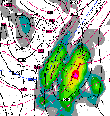
Clouds will increase quickly from west to east this evening. The clouds will be ahead of a fast moving cold front that sweeps in overnight. Widespread showers will be ahead of this and some of the rains will be heavy at times. We could even hear a rumble of thunder earl Saturday. Rainfall amount of a half to one inch will be possible.
Winds will be gusty with temps hanging in the upper 40s to near 50 as some afternoon rays of sun make an appearance. This better weather will carry us into Sunday with temps in the low and mid 40s for highs.
Another system dives in from the northwest late Monday into Monday night and this happens as low pressure develops across the south. This is likely to take this storm toward the Carolinas by Tuesday. A track like that can produce rain and some snow around here. Here’s the Canadian Model…
How much of an impact that has on our weather will depend on the track and if how phased that system can become.
The European Ensembles continue to show a pretty good trough on Tuesday and another toward the end of the week… 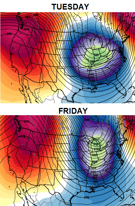 This is a pattern that can crank out a sizeable storm somewhere across the eastern part of the country over the next week to 10 days.
In the longer run… my thoughts about February have changed from my winter outlook. I thought the month would break milder, but I’m not so sure that happens now. The cold shots we’ve been having since October look to continue and I see no reason that stops in February. Throw in an increasing southern jet stream and you could have some wild stuff for the last month of winter.
If you know anything about your friendly weatherdude, you know he isn’t a big fan of late winter and would just as soon hit the spring button by that time. If only mother nature cared what I thought. 🙂
I actually have a rare day off from work today and it looks like I picked a good one. Of course, I also have Monday and Tuesday off and those don’t look as nice. Win some, lose some.
Have a great day and take care.

Thanks for all you do, Chris. I actually get to go to work (school) today for the first time of the new year! Enjoy your day off.
In spite of all the funky monkey extreme winter weather, still not much snow for the usual areas. Crazy even for Darth Bubba to think not even 10″ of snow for Richmond and areas around in three winters (counting this one so far). That is less than 5″ each of the past two and barely 1″ for this one so far.
Past few winters are extreme in everything but the thing that matters most to blog folks here- snow. White gold, Texas tea.
We have had plenty of Clear gold–RAIN!
Cold goes away, count on it-Rain, cold comes back, count on it…Low from the southwest brings rain, then spins some cold in here with 1/4 inch of snow..THAT SUMS IT ALL.
We live in a “Groundhog Day” winter, same thing over and over!
To be honest the lack of snow is what keeps this BLOG HOPING!!! Think about it, why do I keep coming on here to check what “might” happen–its because I’m snow deprived.
If we had a lot of snow, we could careless about coming on here to see what “might” happen, we could just go outside and enjoy the snow!
So I guess until Trend changes, this is what I have…A lack of real snow and a place to come and dream of what might happen. I would trade this site in a heartbeat for some decent snows!!!!!
It is pretty amazing. You have mentioned the trend a lot the past couple of years and I have to agree with you. Last 2 winters we had the rain and now we have had the cold. Maybe we can get the rain and cold to meet up at the same time around here for a love connection and make some snow by Valentines Day.
Bubba – We must measure with the same ruler, one of those small half size ones. Her’s hoping we have to pull out the yard stick, sometime…
Thanks CB for the update.
Storm rolling to the South and up east coast is better than storm going over us and poducing copious amouts of rain. At least if this one phases and deepens it will pull North/West and give us a better chance at wintery precip. Not saying snow just wintery precip. Like to here the cold will stay around for Feb. (if you are correct) as one of these systems will have to come through KY as a snow event. Enjoy the mild up everyone as it doesn’t seem to be around long.
I know there is a long way to go in this winter, but I’m starting to get the feeling that this is going to be another season of wasted opportunities.
when you think about it if we were just batting ten percent. it would be a decent snowfall year.
Enjoy the much deserved days off Chris.I am ready for the warm up too.This cold snap about stressed me out trying to stay warm and keep pipes from freezing,etc.
Thanks for all the long hours spent keeping us informed.
Thanks Chris. Enjoy your day off! Make ti s great one!
Have a GREAT Friday, everyone!
rare day off??? u missed a lot last 2 bmonths, jimmy work for u ALOT
You calling Chris a liar?
that was a kind of rude comment unless there is some joke behind it that i know nothing about……you must remember that most all weather blogs are done by mets on their own time and they don’t get paid a dime for doing it and to think that chris does this 7 days a week, 365 a year at least 1 time a day and sometimes as much as 3 or 4 times a day……..while other mets do well to do it 2 or 3 times a week…..so we are blessed to have a person with so much dedication and knowledge of the weather that we can depend on each and every day of the year…..thank you for your time.
Rolo, no offense but you are not real bright. Keep in mind I said no offense.
It’s always interesting to read this blog and “compare” to what the Paducah NWS office says in their discussion. While Chris tends to emphasize the cold/snow possibilities, the NWS almost always downplays cold and roots for warmer weather. As an example, today’s discussion says nothing about any snow or colder possibilities next week. Chris was describing this past week’s polar vortex ten days before the NWS mentioned it. Like I said, always interesting. Chris is my #1 source for winter weather info.
thank you, Chris! enjoy your break.
let’s get a couple of good snows in here after the warm up.
How about visiting the Mount Washington Observatory this time of year during some time off.
On January 8, I saw a recorded temperature of -19 degrees while west winds were howling at 91 mph for a wind chill of -66 degrees. Winds gusted to 115 mph during the day.
Chris seeing a lot of winter showing up for next week, lets see how long it takes other outlets to play catchup this time!
Thanks for the updates Chris!
He sees a lot of winter showing up every week of winter, I feel like thats all he says.
Neither the Louisville nor Paducah NWS discussions mention any appreciable snow next week. Hopefully, another episode of Chris sniffing it out well before the NWS mets do. Given the Canadian model map Chris shows above, I don’t understand how the NWS doesn’t see it. Oh well.
It looks like the Canadian, Euro and GFS are all showing some sort of winter weather next week throughout Kentucky, however, they vary by how much and the exact locations of course.
On second look though, it looks like the GFS and Euro matchup pretty well based on their snowfall amounts.
Nevermind, scratch that, I was looking at the GFS from two different sites, not the GFS and the Euro, haha. I think it may be time for a nap.
one more and we will call you rolo’s doppelganger 😉
Looks like the heavy snow pack north and west of us will bite the dust tonight with this surge of warm rain going well north this time!
Torch!
We have had one shot of cold air so far. The average temp for this winter is very close to normal. And “the polar vortex” did not break any records in Lexington. The last time Lexington set a record cold max or low min during winter was in 1996. We have been in a warm/less snowy pattern since then. We did have a top 10 snowiest calendar year in 2010, but the last time we had a top 10 coldest winter was 1985–almost 30 years ago.
there were records broke in some places if I remember correctly
ATTENTION:
This is what we are dealing with due to all the waterline breaks from the cold temps! THE CITY OF FLATWOODS WANTS TO NOTIFY ALL FLATWOODS UTILITY CUSTOMERS THAT AT THIS TIME, THE WATER SUPPLY WE RECEIVE FROM THE CITY OF ASHLAND AND THE CITY OF RUSSELL HAS BEEN DISCONTINUED. AT PRESENT (3 PM), THE CITY OF FLATWOODS HAS APPROXIMATELY 4-5 HOURS OF WATER IN THEIR TANKS. WE ARE ASKING ALL RESIDENTS TO PLEASE CONSERVE WATER!
It would be nice to have a spring or well in place for cases just like this.
yes deff, we have a farm and my husband came straight in from work and made sure all the animals had water just incase they did run out, I know they said to conserve but we had to make sure the animals were taken care of!
Plenty of winter left people. Louisville will still get enough snow to call it an average winter. Of course if you just look at the past 15 years we have already hit our average.
Rolo can say what he wants. Just as everyone else on here. Chris know who is being offensive and who is not.
THINK SNOW!!!!