Good Saturday, everyone. Heavy rain, wind and thunder welcome in the weekend as a cold front slips eastward across the state. This is a fast moving system that will zip through here pretty quickly today and that leaves us with a nice afternoon and an even better Sunday.
Here’s regional radar to watch today’s action..

Sunday sees the sun return with temps in the 40s. That’s a nice way to end the weekend you should get out and take full advantage of it. Old man winter starts his comeback next week.
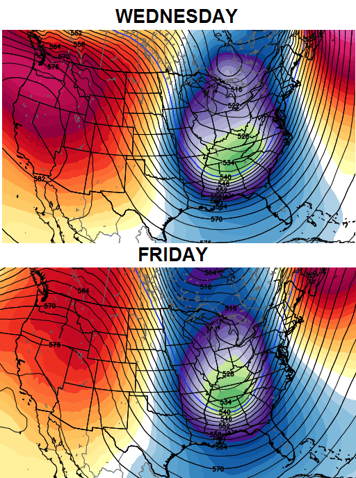
A series of troughs dig into the eastern half of the country over the next week. Each will bring colder air than the one before it and each will have the potential to bring some snow our way. The European Ensembles show the way…
I will talk more about individual snow chances with the week ahead as we go through the weekend.
The week after is when we should start to see true arctic air getting involved in the pattern again. Take a look at the signal coming from the GFS Ensembles…
Getting a sense of what we are dealing with here? Deep troughs targeting the eastern half of the country over the next few weeks. That’s a continuation of the overall pattern we’ve seen since October with plenty of cold air funneling into our region.
Again… enjoy the nice stuff coming later today into Sunday.
Take care.

Wow how intense! Here in Lexington, I saw a huge bright flash out my window and a loud clap of thunder not even a second after!!!!! Weren’t we just below zero a few days ago and now it’s mid-winter and it is storming outside IN THE MIDDLE OF THE NIGHT AND TEMPS NEAR 60!!!!! Now that’s some crazy stuff for ya (definitely a blowtorch out there)
Crazy weather. But its happened before, it will happen again.
Central / eastern/ south east Ky will eventually get a big snow. May not be this winter, or we may get thumping, or partial thumping like feb 2012.. it was a Sunday, started as rain but quickly changed to snow. I think I had 5 half inches here in northern clay co.
yep- some crazy weather for sure!
maybe, just maybe we’ll get a couple of good snows or even a big one in the weeks to come….
take care all and GO CATS!!!
mother nature has put us in a good position to receive some snow.
now let’s see if we can execute it.
Thanks Chris. The old adage about weather in Kentucky still holds true….if you don’t like the weather here, stick around ’cause it will change! Have a great day everyone and GO BIG BLUE!!!!
I’m a heavy sleeper, but a crack of thunder this morning that sounded more like an explosion woke me from a dead sleep!!! Strange weather indeed.
WOW…nothing like a BOOMING thunderstorm to wake you up in the middle of a January night. Pretty exciting. Looking for some more snow chances, that is if we can get some wet snow conducive for snowmen.
We are nearing the midpoint of winter (for record keeping purposes). Lexington is even for temps and 0.6 inches below normal in snowfall. The past two winters were warm with below normal snowfall. The two winters before that were cold with above normal snowfall. Stands to reason this winter would be average.
We are about at midpoint here in Knox Co. and sitting at about 1.5 inches total for the year. A waste of a lot of cold with little snow to show for it. Nearing the halfway point of January and nothing big on the horizon. I know February and March produce some big snows, but once the middle of February average highs start to creep to near 50. I would personally like to get a big snow or two the next two or three weeks and then let the blowtorch take over. It didn’t really warm up until May last year and I don’t want to see a repeat of that.
I hope we can get some good snows before February is over with. After that,then Spring and warm weather is welcome. Thanks CB for all you do. And Barb and Summerbreeze,if your out there,I just wanted to apologize for offending you in any way. Everyone has a right to there opinion,and just because mine may differ at times,doesn’t give me the right to criticize you guys. God bless
Hold your ground! Part of avoiding a “blahg” and having a blog is a little bit saucy action to compensate for another likely snow let-down for winter (for the usual missed places).
Big snow is out and Extreme, Polar Vortex (hey, we see diagrams on TV so it must be real), Ice, Mega Mix, Thunder Snow, and Wall of Snow are in!’ 🙂
Still not big snow threats. We used to at least CB blogging about it and it not happening, but now we do no even get Lucy’s football.
Next week will see the usual mix & ankle biter chance, followed by lots of salt on the road (no offense, BJ) and on cars. Nope the trend is slowly turning the blog into a “blahg” and that is why we need:
The TORCH! To post warm air centric themed posts. Today is your chance! 🙂
The Goat Whisperer… shh.. To post about busts and then old school, sometimes from one post to the next and then a nice pat on the back.
Darth Bubba: Nah, the weather has become so “blah” that even Darth and the Dark Side think things have gone far too darker for snow lovers. Even the Dark Side has a heart, though dark it be.
Fear the Fence! That is my rambling quota for the weekend 🙂
My typing was bad like on a phone, but I am not. I ain’t got no typin’ skills.
Why do you post this stuff? Is it for your own enjoyment?
Because he can!!!
I guess he can. Whatever!
You can too, and did.
Overcompensating to hide his secret love for Nickelback. 😉
That was low too 🙁
What’s with the selective indignation? There have been far more egregious posts by others of various sorts, yet no similar post? Why U B pickin on me? 🙂
*their
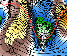
NWS Louisville discussion now seeing what Chris has been for the last few days, much colder and better chances at snow, Wedensday system now looking interesting for a decent snow!
Yeah, quite a discussion without an eminent storm on our doorstep. It’s always fun when there’s not much predicted and then the models all turn toward a big event. Not saying it’s going to happen, but have seen some big snows around here with little fanfare until 36 hours out.
53 and sunny in Lawrenceburg. 60 degree warm up in air temps, 80 degree in “feel like” temps since Tuesday. Time to break out the shorts, flip flops, and fire up the grill.
I think Wed. event is a clipper deal.Of course i could be wrong.
Fear the moisture from the Gulf.
I’ll take my chances with a clipper, the southern fed systems always bring the torch with them!
Atmosphere too warm and energized.
Absolutley beautiful blue skies with fluffy white clouds racing across. Temp is 65 F. Looking outside, you would think it is a windy, March or April afternoon. I consider it a gift, and I am thankful for it.
I was glad the ground finally thawed out enough to get my outside decorations taken down. Now let the snow commence.
My yard was frozen solid as rock two days ago and now it’s squishy like quicksand. My neighbor drove off her driveway just a bit and got her car stuck.
The wind is making my horses run so they are creating huge holes where they could barely walk earlier this week.
The freeze/thaw mud season of winter truly does depress me.
Letting my dogs out and having to spend 20 minutes cleaning the mud off their feet is depresses me.
Oh yes, I have four tiny poodles who leave teensy little paw prints all over the kitchen floor when they come in from the yard. Of course, they were not allowed outside when the temps were frigid. PoochPads were my stylish rugs.
Temp has dropped to the low 40s in frankfort after being in the low 50s this morning, wind picking up also!