Good Sunday, everyone. Our weekend is wrapping up on a nice weather note across the bluegrass state. Make sure to get out and enjoy the nice because a series of cold fronts are on the way for the week ahead. Each of these will bring colder air than the one before and they will have the potential to bring some snow to the region.
Today’s temps will be in the 40s across the central and east with low 50s in the far west. Skies will be mostly sunny with a nice little breeze kicking in. That breeze will turn into gusty winds for Monday as a cold front works into the region from the northwest. A storm system to our south and southeast will throw some moisture northward along that front and that means showers develop as the day wears on.
That front will be followed up by a more vigorous system diving in here late Tuesday into Wednesday. This is a potent clipper that should bring a band of, at least, light snow to the region. Winds will really crank and thermometers will drop quickly behind the boundary.
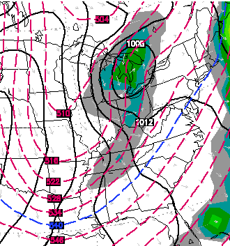
Highs in the 20s and lows in the teens will be a good bet by Wednesday.
Another potent system dives in from the northwest by Friday and should also bring a round of some snow our way. This will also be a big wind maker and will usher in even colder air late Friday into Saturday.

Looking farther down the road, you are likely to start hearing about a possible return of the polar vortex by late in the month or early February. That doesn’t necessarily mean it will give us the exact same conditions as it did the last time, but it’s something on my radar. I’ve talked about this potential for a while and the European Ensembles are picking up on this possibility…
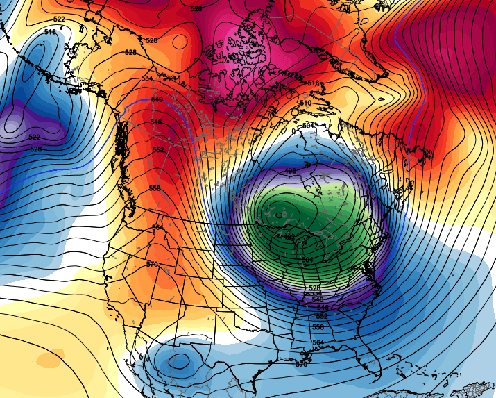
That’s a lot of blocking showing up over the top of the PV and would mean it wouldn’t be as quick to leave as the last one. Again… that’s a couple of weeks down the road, but it’s interesting to see.
Make it a great Sunday and take care.

Chris not hearing much about snow guess we just might get the cold….
Dodger thinks the snow chances this week are weak. No major storms to speak of on the horizon 🙁 Dodger
As usual, thanks CB for keeping us informed!
A little history. It was on this very date way back in 1890 that a tornado outbreak occurred, including an F4 in far western Kentucky. One of the very few times that F4/EF4 twisters have happened in KY/TN in January.
To be sure, that particular winter was insanely warm. But it might seem counter-intuitive that F4s/EF4s can happen in winter within our area, but only twisters of F2/EF2 and weaker have been recorded during July, Aug and Sept in our locale. After all, we get lots of summer t-storms, but only a few t-storms during the winter.
Part of the reason is that winter, like spring, can have a strong jet stream. This can create lots of shear (and thus twisters). However, the jet stream tends to be weaker and farther to the north during the summer.
But for the short term, looks like we will have to be more concerned about wearing parkas than watching for funnel clouds.
the only clouds I want to be watching is snow clouds.
I don’t post often, but I noticed that Lou. NWS has changed their forecast discussion format. Not sure when it changed, but the new format appears to have more information specifically regarding “impact” to our area. Hats off to NWS in Lou.
Looks like nothing big going to hit this week. That will put us past the midway point of January and the dome is still holding strong. I’m really starting to think the “big” one just won’t happen again. We have had warm winters, cold winters, and in between winters, and one thing they have all had in common for over 15 years now is that none of them has produced a good size snow. Wish it would just move on to the tropics and at least give us some weather to get out of the house in.
NWS hinting about some convective type snows Wedensday, that could be fun for some folks, hopefully its widespread enough for all of us to enjoy?