Good Saturday afternoon, everyone. A clipper continues to dive southeastward across the region and will deliver another light snowfall. This snow will be falling on a ground that’s frozen and that means slick travel is a good possibility into Sunday morning.
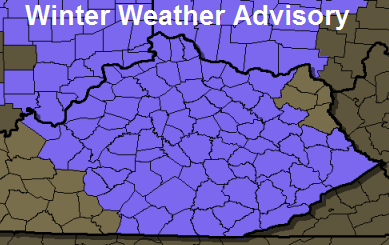
A Winter Weather Advisory is now out for much of central and eastern Kentucky into Sunday morning. Here’s a look…
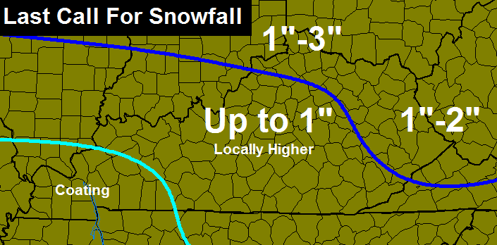
My thoughts on snow amounts remain unchanged from my earlier updates. I did beef up the totals just a tad in northern parts of the state…
Gusty winds will blow the snow around and reduce visibilities from time to time.
After this… it’s full steam ahead toward the return of arctic cold for the week ahead. This will mean additional snow chances with the next one coming late Monday into Tuesday.
Let’s get back to tracking the stuff we have today…

Current temperatures

Winds

I-75 @ Winchester Road Lexington

I-75 @ Iron Works Pike Lexington

I-75 @ Clays Ferry Bridge South Between Lexington and Richmond

US 60 @ US 127 Frankfort

US 127 @ Frankfort Frankfort

I-75 at MP 36 London

I-71/I-75 at Buttermilk Pike Near Covington

I-64 @ 3rd St. Exit Louisville

Downtown Louisville @ 2nd & Broadway Louisville

Have a great rest of the day and take care.

Thanks for the update, Chris! My corner of Harlan County ended up with a trace of snow yesterday. I see we’re in the 1″ or less range for tonight. If this system wanted to be an overachiever, I certainly wouldn’t mind.
Virga party well underway in western Kentucky 🙁 ugh!
Not much better here in central Kentucky. Just cloudy skies for the moment.
But cautiously optimistic about good snows the next few weeks. For all of Kentucky, not just for Louisville and for far northern Kentucky.
Thanks for the update Chris its really getting old being left out of the snow party
Thanks, Chris for all you do for us “weather weenies”. Hope we cash in on some of the snow chances in the weeks ahead.
Looks like NWS backing down for snow potential tonight, careful, you got bit some Friday morning in certain areas, Northern KY again is the sweet spot as usual this winter!
tail there behind main push look to give SE KY s ky little more than expected as it will expand as it drives int5o mountain. I see a general 1-3 area wide.
only thing is we are wasting this DEEP COLD, meaning if we could get a southern storm now we get snow, not mix, this as we go thru next couple weeks as well. wer just need a OKLAHOMAS PAN HANDLER to come thru turn up apps.
I’m in Bowling Green today visiting with my daughter and the radar looks like we having been getting a good snow for the past hour,but not the case. Not a single solitary flake. Virga only thus far. The wind is really howling though. Burr. Thanks CB for all you do for us.
Starting to snow here in NKY, very light, dry snow.
I looked up CVG’s records and yes the airport is at 21.2″ for the season with just over 8″ for January so far.
* looks like we have been getting ( sorry for the bad gramner.Fingers are ffrozen. Lol)
I’m the Absolute Vorticity forum they are talking about pressure falls of -4 into TN, indicating the low may track further south than anticipated.
Anyone out there actually getting any snow from this? And if so,where are you at please? Looks very impressive on the radar….
Radar looks impressive over Frankfort, as well. But nothing falling 😀
What’s impressive is the donut hole over Louisville and surrounding county’s the precip is having nine kinds of trouble get through the dry air in place.
Dodger says we missed again to the north. Will this dance change in coming weeks? Sure hope so! Dodger
Nothing but virga in Casey Co.
Looked at mesonet earlier and my area was showing humidity of 71%. Must have had some dry air move in because it currently shows 53% with the radar showing some good snow over the whole county. Yet, no snow to be seen. Happened yesterday for a long time. We had a lot of snow showing and it took so long to get the humidity levels up it was mostly gone. That resulted in only a light snow. I occasionally saw a flake during that period. Finally it started to snow pretty hard but by that time the majority of the line was gone and we picked up a quick half an inch before the snow blew by.
http://media.graytvinc.com/images/250*100/NEWSevereWxDay1.jpg
http://youtu.be/o9ZgnVb5Q7I
It would be nice to see the lower level dampen up a bit… The ceiling looks to be pretty high still… not a real promising sign for the Lexington area… but a flake is a flake! I’ll take what I can get!
well.-temp at 29 in Lawrenceburg. Whatever falls will stick but I will doubt we get an inch overnight. I did shovel and scrape my driveway just to see what falls overnight 🙂
Virga storm sucks, dry air aloft winning the battle!
haha, severe weather day… nice hype for a dusting
Not a flake has flown in Louisville. Clipper BUST.
Finally starting to snow here in Clarksville.
Er… was snowing.
radar shows snow here but nothing falling yet! : (
Underachiever should have been expected as the last one over achieved in some spots, Oh well, some trends are so hard to bust!
Nothing here in Northern Scott Co. either…
Again, one of KY’s most hated players in winter, Virga storm, we always have to fight some negative snow force of nature in KY!
The dry air is so intense over central kentucky it is entirely possible if not likely that we don’t get anything by tomorrow morning.
The clippers have been very good to Ky in past years but havent done much this year for most of Ky. The air is just too dry right now.
Notta flake in Versailles
Not even so much as a single flake in northern Lincoln. Did anybody actually expect anything else? What a joke.
Versailles the city of dustings!
Salt stands at 900lbs……Not needed for the verga today…..hopefully a few snows this week will allow me to move it.
Thanks CB for the update. Hopefully we have better snow luck once the cold air moves in next week.
Where is BubbaG?
Bubba g is sitting back laughing at everybody getting worked over a dusting that never materialized along with a severe weather day declaration for the same non event. Kentucky weather is what it is, Dissapointing to say the least.
Looks like another MAJOR model BUST, most saying atleast 1 inch tonight, Deck duster is in question now!
yeah busted by 1 whole inch lmbo
Not a flake in knott co, what dusting we had melted with sun today.
I still can’t believe they have a winter weather advisory for 1 inch of snow. I went to Kroger this morning and the sun was shinning but it was a pretty good snow falling. I’m well into my 50’s and I can’t believe the way weather is having an alert for 1 inch of snow. I really like this blog, but lets get real. 1 inch of snow is not worth putting any type of warning or advisory out.
Is there anymore snow coming behind this first wave? Nothing falling in Harrison with the first…
I think that it will be scattered in nature still best… not an educated prediction, but an experienced one! 😉
Regardless of t he lack of snow tonight… My son and I are making the best of a fire in the ole’fireplace and the tent thrown in the family room floor!
*at best
Just saw 3 flakes on the way home in Laurel County. I guess that makes it not a 100% Virga storm. Maybe a deck duster with the remaining bands? Not a big deal, looking forward to some excitement next week in the weather world.
The NWS should cancel the winter weather advisory, this thing has died out as it came into KY, SURPRIZE!
A few deck dusters later if your lucky tonight!
It’s pouring here in greenup
NWS in Louisville had a electrical fire all staff is out according to John Belski. As far as this clipper system goes the dry air won the battle only flurries in Louisville and that was short lived.
Maybe they will bring in some newer more reliable equipment .
About 1″ here in northern KY. Maybe the scattered stuff in IL will give a bit more.
Deck is dusted in Morehead 9:00 p.m. And the snow’s stopped. Oh well.
Can’t help but laugh anymore at Kentucky winter weather.