Good Friday, evening. I wanted to drop by for a quick update on the winter potential for later this weekend. The GFS is finally seeing the system we’ve been talking about for the past few days. Here’s what it shows…
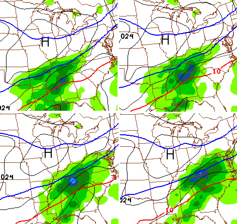
I think it has a little more work to do in coming north and getting wetter, but it’s certainly in the ballpark. Here’s the latest snowfall forecast from the GFS…
The model is also trying to spit out quite a bit of freezing rain in the southeast…
Again… that’s what the model is showing and not my specific forecast. By the way… notice the touch of freezing rain across northern and western ky. That’s from the early Sunday mix.
I will have an update on WKYT-TV tonight at 11 and will have a new post later tonight. Take care.

70 miles shift to the north would be great.
it would put Louisville in a nice spot
without taking a lot of snow from other starved areas.
According to that all the Se gets is freezing rain so a shift further north would take the snow starved even further out of the equation. Its going to be a narrow band of snow you wont have to go far to see bare ground of you are getting snow
Now I’m sure the twc will add it in their forecast..they LOVE the gfs lol
Yikes talk about ground zero for that super slick stuff look at letcher. Yuck no freezing drizzle we got hit with that a couple weeks ago and it was awful
Thanks Chris. Keep us posted.
It seems as if lots of fingers were pointed CB’s way about creating hype about next week. Anyone that read his blogs knew he was just talking possibilities which is what this blog does. However some ran with it and called it a hype machine. Marc Weinberg was positing about hype machine on his blog.
Most knew it was not a forecast but tried to make it bigger then what it was. Over dramatize and point fingers. MW is great at this. Today by coincidence MW has the same storm being discussed that CB was discussing Two days ago. In matter of fact he has some maps posted that show winter storm totals for parts of the state. Is MW starting the hype machine? If a met can throw others under the bus why can’t they give credit where credits due
I have been reading the blog for years and think this may be CB’s best year. I have always been informed of the possibilities and to me that is what this blog is about
Nice job CB and keep doing what your doing. To the others who like to look like Mr. Right or start saying things that just are not true look in the mirror before calling out others
Talk about going from the penthouse to the outhouse. The 06z NAM had far SE KY in heavy snow and now the 18z GFS is showing freezing rain. For what it’s worth though the 18z NAM is still showing snow for far SE KY. I still think the models have some flopping around to do over the next 24 hours.
when in doubt go to the nowcast forecast.(lol)
I put no faith in ANY model until 12 hours or less out……but……the GFS hasn’t nailed hardly anything all winter but the NAM has been “fairly” accurate in the grand scheme. So……I’ll buy into the NAM before the GFS any day.
I agree with you there. It just seems to me that the NAM is mostly on an island by itself right now.
The next two or three model runs will be interesting to see if this becomes a trend.
Less than one inch Sunday on the GFS in central KY, looks like flurries to an inch, then a major rain storm with back side flurries tue/ wed, hoping models are wrong??
Spring is sounding good, as we watch the north get hammered again with snow the next 10 days!
Backside flurries the trend of the last 15 plus years. lol One of these days we will get one. Just wish that my older kids would have gotten a decent snow while they were younger.
My prediction (for what its worth) is this thing shifts North. Same trend as the last few years. Anything looking good two days out ends up missing the forecast area. Have to be on the northern edge of the storm to get it. Already north of Knox Co. according to the GFS, so highly doubt this area will be back in play.
It’s a good bet that this does play out as you stated, but don’t base your conclusion on the GFS, as it has been the most inaccurate model all winter.
Stop being so negative 😉 i mean realisitc
Glad to see that you are turning it around in the right direction Andy. All your negativity and repeated posts about not getting any snow is killing the board. lol
Maybe this summer when you are still following the board and all the others move on to something you can post your negative thoughts in peace. (sarcasm noted)
Not moved anywhere always the realist never the dreamer 🙂
Lots of good ones I miss from the board from years ago. Wish they would just let CB police it. Lots better with the different opinions being stated. Would be boring if it was just an atta boy all the time. lol
I speak to several on FB and they no longer post because of the haters like earlier.
Personally I trust the nam more than the gfs this close in. It seems to be more accurate so far this year.
Chris I miss the old blog when you could get on here and tell us your thoughts not worry about these crazy people taking everything and running with it now you ave to say gusset model not my forecast I really miss the old blog…
you can blame it on Chris popularity:.
Bubba stated a couple years ago that the nam does better with storms or clippers coming from the north.
I think this is true for the most part,
since this storm is coming out of the south I would not rule out the GFS.
NAM has been pretty good less than 48 hours in. The actual result of the model is usually not as important as the directional trend (waffles and all). Will be interesting to see how the GFS pans out for Sunday.
The Tuesday expected event seems a gully washer for us. Bunch of cold rain with the some back-end mix. We always seems to get it in the “back-end” as far as snow 😉
00z NAM looks stronger, still has snow in SE KY, moves some toward Eastern and Central KY too it seems.
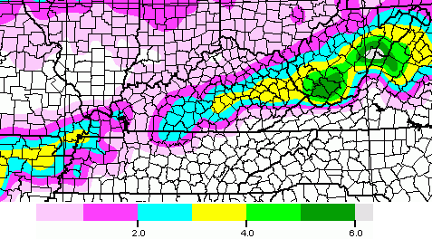
00z NAM actually shifted north some. Shows a fairly large swath of 8-10″ snows roughly on a line from Monticello to Corbin, to Hazard to Pikeville. Snowline ends before it gets to Elizabethtown, Lexington, and Morehead. Of course this is just one run of one model and should probably be taken with a grain of salt.
What about greenup county?
Western KY stands to miss the Sunday night event and see all rain from the Tues/Wed system. Since early December, we’ve been pretty much shut out and I’m growing more and more disenchanted by this winter of extreme possibilities and constant misses 🙁
Chris just tweeted a teaser. AKA tweaser.
He’s smelling it lol
It could be time for a “bam, goes the NAM”!
ok, so it is technically Saturday! we needs an update!
I agree….waiting on that update…..:)
http://blogs.agu.org/wildwildscience/2014/01/31/the-great-facebook-blizzard/