Good Saturday, everyone. All signs continue to point toward a developing winter storm to target parts of the bluegrass state Sunday night into Monday morning. Because of this increasing potential… the blog is now in Winter Storm THREAT mode.
For those who are new to the site… a “Threat” means I’m seeing the potential for 4″ or more of snow or enough ice to cause issues. This does not mean it will happen, but it is to raise awareness to the possibility. If my confidence grows, then I will upgrade to an Alert. If things change toward a lesser system… a downgrade will be necessary.
The NAM and GFS mad the jump north, as expected. Here’s the GFS…
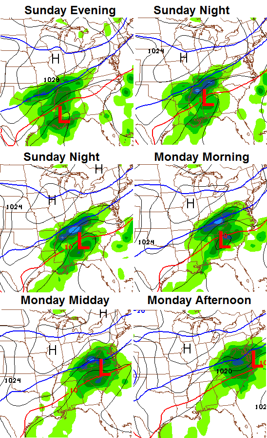
The Canadian Model has more moisture and is a little stronger with the low… 
If the models hold course… where will the heaviest band of snow set up? That will be the question of the day and I will also be watching for the possibility of a band of freezing rain setting up.
Again… we’re inside 48 hours of this event and this is when you usually start to see the models coming in line. I will wait until later today to put out a first call map, so make sure to check back. That should come early this afternoon.
Have a great Saturday and take care.

Hoping this slams southeast ky with snow, and not freezing rain
Why? Same result (widespread long lived power outages)
Go Canucks
C’mon show some love for SW ky.
Sorry SE
Looks like SE ky is right on the line for snow or freezing rain
Good grief! When will this end? I don’t want to have to go without water for another week. The line freeze and burst between where I live and Hazard. Can’t we please have some 60 or 70 degree weather? LOL If it does come another snow, we’ll just enjoy it!
What do you consider the “evening” timeframe?
If this turns out to be a mod/hvy snow event Sun night into Mon morning; what if any effect will this have on the bigger storm coming in Tue/Wed., i.e., a track change, higher risk of flooding if all rain etc.?
This looks like it will be a heavy snow or freezing rain be prepared for the possibility of no power se ky.
Wonder if Tennessee will get anything from this system Sunday night. Anyone please feel free to comment!
Yesterday looked good for East Tenn…Today not so much..Meteogram spitting out some good numbers for Eastern Ky..
http://www.meteor.iastate.edu/~ckarsten/bufkit/image_loader.phtml?site=kjkl&nam=on&gfs=on&rap=on&nam4km=on&ratio=11&max_t=on&cobb=on&compaction=on&mean_mt=on&max_mt=on&mean=on
That”s with 11-1 ratios
Sry,,Meant middle Tenn Looked good yesterday..
so based on models is this looking to be an apps runner?
Thanks Ready4Snow for answering my question. Was hoping to see some beautiful snow!
Don’t know what part of Tenn you live but would like to add that anybody North of 40 and west of Crossville Tenn looks to be in a good spot.. Of course thing’s will change throughout the day..
Watching Weather Nation………..they mentioned lack of snow in Nebraska……I looked and so far this winter season Omaha has only had 5.4 inches of snow………crazy.
Looking at the models, does that put SE KY in line for rain/freezing rain? Can’t tell much about them. Also could this system shift to be the bullseye on SE KY? What are the possibilities?
looks to be freezing rain vs wet snow right now, anything is possible at this point likely a lot of “now casting” with this one.
Looks like central WV could be looking at freezing rain then snow. Thanks Chris, I will be staying alert for your first call later today.
So question… If I have a business trip driving from Central Ky down to Atlanta Monday morning, should I be looking at going Sunday instead?
thanks Chris.
wow, you never know…everybody talking about the mid week storm and here comes this one puffin’ up!
Low will move further north.
They never move north when it means sweet spot for Louisville. At least some in the state will get to enjoy
I don’t think Louisville will be sweet spot. But, southern part of county could get 1-3″ and the areas bordering the river maybe just a dusting or as much as 2″.
Louisville to the Parkway could see a few inches by Monday morning. Bad timing for the kids going to school.
Southern Indiana shouldn’t see too much, as there will be a sharp cutoff.
Southern Jefferson county in Louisville would be the sweet spot this time, Valley Station, Fairdale areas.
Agreed…southern Jeff and bull it, etc should see best chance of 3″.
Ready4Snow I live in Morristown Tennessee. Thanks again!
Morning all. Wow! We are actually in threat mode. Those are few and far between in my part of the state. Looks like we are in for something, hope it’s not ice. Guess we’d better get out and enjoy today. Well, if it does snow, I’ll just enjoy that, too.
Chris, thanks for the update. Anxiously wasting the next one. Have a great Saturday everyone and GO CATS!!!
Hoping for low to shift back to the south a bit, even if it means most of you in northern KY not getting in on the action…. Sorry, but anything that keeps us in the southern tier counties out of the line of ice/freezing rain is a good thing even if the northern tier counties get left out. I’m definitely gonna be selfish in this case. 😉
Sorry Troy lol
As a side note, If there should NOT be any ice/freezing rain involved, I don’t really care where the low heads. In that case, I would be happy to share. 🙂
Haha. Deal
This seems to be more freezing rain for frozen stuff for main impact areas. The irony could be the sweet spot for the most action is also the main freezing rain area. That would be more like being in the sour spot.
Be interesting to see if it pans out and what form of frozen stuff. Snow is the preferred main action. Duh.
12z NAM CRUSHES SOUTHEAST KY, could be overdone in the amounts for Monday.. Guess we shall see
I would expect a little of a northern shift, but due to the potential ice factor, not sure who that is good or bad for. Just a few degree temp gradient in regards to warm air aloft can be the difference for ice, sleet or snow.
We need CB’s interpretation of the mess.
Agree. 12z nam looks bad for ice to set up.
Can you post the 12 nam?
Well, looks like we better get prepared to be without power for a week or two here in southeast ky.. We’re already without water due to the below zero temps. Might as well make it a double whammy. It’s kind of funny how everyone was talking about the midweek system for days, and thats not even the one thats bringing the heavy snow.
Well, on a positive, the post from CB was nine hours ago and CB 101 is if the system is trending more or the same, he tends to tweet or update more. The gap could suggest the system is not looking as thought and he needs more info to confirm.
Either that or he has other stuff to do, but I lean more on the former. Too much behavioral history to discount the gap/outlook factor outright.
Positive in regard to if ice.
I have to sleep sometime! 🙂
Going for a run then will update things. Too nice outside for me to not give the day a little time.
That stuff is so overrated 🙂
Freezing Rain could be a real issue as well, which may undercut snow totals in the south…this would be a heavy wet snow..then to make matters worse, followed by potentially high rainfall totals mid-week falling on top of heavy snow and a frozen ground, certainly a situation that needs to be monitored closely, run-off could be quick and raise river levels fast
When do the next models come out? I live in mercer county and if we are talking ice I need to get things ready. Thanks to Chris for keeping us prepared !
Lexington I’m line for freezing rain?
In
I don’t enjoy the storm situations where we’re on “the line.” Hopefully everyone gets a good wet snow out of this. The kids need a time to build a beefy snowman and not have to endure with powdery snow and such cold temps. NWS says 3-5″ looks good from London to Lexington and points east. We’ll see how that holds up.
A preliminary estimate for snow totals based on the 06z/01 run of the NAM puts part of east and southeast KY in line for a Winter Storm Watch already.
London, Somerset, Pikeville included.
Portions of far southeast KY from Whitley to Letcher counties could get interesting, if not tricky to forecast.
The18z run should be the most accurate part of the NAM runs before resorting to Nowcast.
What does it look like for Mercer county plz?
I live in far Southern Indiana (Corydon) close to Bradenburg do you know what it looks for snow please?
I don’t consider this run to be the most accurate part of the NAM’s runs. But, based on the 06z run, 2″ or less for Mercer County. Stay tuned to CB’s update in a little while because I hear that the 12z run looks even more interesting.
This graphic from NWS Louisville looks good!
http://www.crh.noaa.gov/news/display_cmsstory.php?wfo=lmk&storyid=100081&source=0
Thank you for posting… !!!
Here is a link to some of the models http://coolwx.com/cgi-bin/getptype.cgi?region=us&model=nam&run=12&fhr=02&field=ptype
12z NAM Snowfall
http://forums.accuweather.com/index.php?act=attach&type=post&id=223328
12z GFS Snowfall
http://forums.accuweather.com/index.php?act=attach&type=post&id=223360
the GFS is better 4 cities along the river.(ohio)
this will probably not be settled until after the 0z runs.
my boy Wilson n Owensboro will be routing hard for the GFS.
the man need some snow love.
Distance wise – Lexington is half way between Chicago and Atlanta……
If a low pressure goes through ATL, would Lexington be in the pefect spot for the snow? I’m only saying this because if a low goes through Lexington, Chicago is in the perfect spot for snow…..
I see what you did there
NWS Jackson has posted 4-6 inches for parts of Eastern KY Sunday Night. I’m kinda shocked that were not even under a WWA at this point. Not to mention the ICE that is a possibility… Wonder if everyone has just football on the brain lol
Well, at least thanks to Chris and this blog I get a heads up and can get the generator gased up, tractors in the shed and wood on the porch! Thank you CB!
This storm for some reason doesn’t add up to me. Something doesn’t feel right. I like to always stay positive but I just don’t see this or the mid week storm working out for us snow lovers. Hope I’m wrong.
Tomorrow night is going to add up just fine for many snow lovers.
So Northern Kentucky is completely out of this Sunday night weather adventure?
F Test