Good Saturday, everyone. Today’s weather has your friendly weatherdude longing for spring… that I simply cannot deny. Old Man Winter has other ideas and is going to throw a lot of winter our way this month. That gets started with our developing winter storm moving in late Sunday into Sunday night.
Some thoughts…
– Heavy rain develops overnight into Sunday morning. This will be along a slow moving cold front that sinks in from northwest to southeast.
– Some light freezing precipitation may develop across the far west and north late tonight as low-level cold air settles in.
– Temps Sunday will slowly drop from northwest to southeast as the front inches through. A developing area of low pressure will then work to our southeast Sunday night and Monday morning.
– As this happens, snow and freezing rain will develop Sunday evening into Sunday night.
– We are likely to see a heavy band of snow setting up from southwest to northeast. Figuring out exactly where that develops will be the key to figuring out who gets the most snow. We are also likely to see a decent amount of freezing rain developing in the south and southeast. That should cut into snow totals in those areas, but may create even bigger issues because of ice.
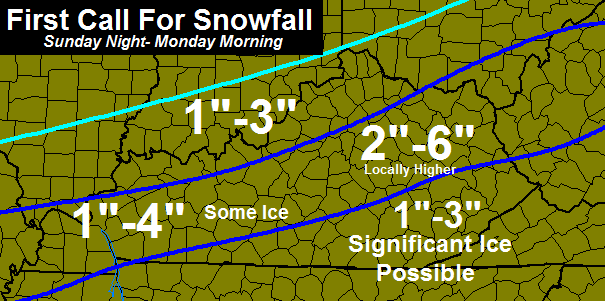
Here is the First Call For Snowfall…
Keep in mind… that will LIKELY change a few times as we get closer to the storm. This is just a very early look at how this may play out.
I would hope Winter Storm Watches are issued to give folks a heads up about the potential nastiness on Super Bowl Evening and night.
I will have updates later today. Take care.

Crud. The dreaded “I” word. Hope it moves a bit south as I do not want ice! Thanks Chris.
To borrow an acronym from another blog… BOTS—-Bring On The Spring!
Thank you Chris for keeping us safe. Tomorrow night there will be a lot of folks on the roads. I sure hope the NWS issues something before it all hits….
Pretty much right on with what I was thinking @ 7 this morning.
I love these sneak up type of systems that only give you a 48 hour window from first time showing up on models, to the time precip starts.
Everyone be on your toes for a wild February.
I know that NWS Charleston WV won’t issue a winter storm watch because they always underestimate the snow. For example, during our last winter event, they called for 1″-3″ of snow in northeastern kentucky. I went out and measured several spots in my yard that made it well past 6″ of snow. Oh well.
I’m with Coffeelady, no ice. As much as I love snow, I hate no power, and ice always means that.
I’m with you too. love the snow hate the ice.I like my electric too much.
another storm with a dusting to 6 inch prediction lol that will get ya right 99% of the time around here
You must have failed Map Reading 101.
Yeah, because his map says dusting to 6 inches for the whole state on it. Bill, is that you? Good try there cowboy.
I don’t know who Bill is, sorry.
So, help me out here. If our state, like it often does, finds itself on a snow/ice/rain boundary line, and different types of precipitation/amounts are likely, what sort of forecast is Chris supposed to give? It seems to me he did exactly what he should have, shown what was most likely depending on what area of the state you’re in.
And I really didn’t come here to argue, but the criticism above just seemed totally unfair to me. Uh..cowboy?
Okay Louis on second reading, I may have misinterpreted your post, if I did, sorry. If I didn’t, well…read what I wrote lol 😀
Seems like the two of your are making the same point..toward the Realist?
I was replying to the other guy, not you John. I guess you misread the way the thread is laid out. 🙂
thanks Chris! you’re always all over this crazy weather.
beautiful out right now – like a spring training day!
settling in to watch the Cats!
The Realist, I would much rather have Chris say there is a possibility of up at 6 inches of snow than to hear the loud mouth on WLEX not say anything until it starts to happen. I’ll take Chris’s batting average over yours any day.
You know, I used to like Bill Meck but over the years, not so much.
Amen! They’re not talking about snow at all right now despite even having the special weather statement issued. People think that because they wait until it happens and THEN forecast it, that means they’re more accurate. Noooo.
And Tom Ackerman is getting even worse than Bill Meck.
Heck, anybody can do what Meck and Ackerman do. Chris actually puts a lot of thought into his forecast. Thats why hes #1 to me.
everybody chill out.(lol)
Your right. I read this blog every day multiple time and enjoy it. My wife teaches and I send her and her co-workers updates on what Chris has to say. I very seldom post, but I just did not like that comment. It is called a forecast for a reason, it’s what you think at the time may happen. Is Chris right all the time, no, but I give him props for at least not going by what someone else has written.
Oh WOW. I’m with Coffee Lady…let us not speak of the “I” word. Would just love to have a big Somerset snow so we could build a snowman in honor of our Most wonderful weather dude. Thanks CB
for keeping us informed.
Very grateful for the update. Even though I am in WV, and Nicholas County is often just off your maps, your forecasts are very helpful to me as there are many times, particularly during storm season, that KY weather ends up in WV anyway or I can extrapolate our weather from what you post here.
Looks like Bowling Green may actually get some snow this time? The most any single event has brought us this year is just a little over an inch.
I am hoping for a continued shift to the north so NKY can get in on the action! Snow from last weekend just now melting away and we need replacement!
If these runs keep this up Walmart will be busy tomorrow. For those of us that looks like ice is possible , make sure you got gas for the generator. Better to be ready and not happen then not to be ready and it does. But I really hope we don’t get ice.
If you don’t care, drop that snow line just a bit farther south so the other half of MAGOFFIN county is out of the “significant ice possible” zone! #NoIcePlease
Where does this put Nelson County? It’s right in between the 1-4 and 2–6 range and also says some ice. Also, no comment about tues/wed system for the last few blog posts so I guess it’s a non-event now.
I think the locals are saying around 3-5″ of snow for us, SHAAK! That’ll be sweet, IF we can get it. Our luck, this time it will all go South of us…not to be a Debbie Downer, but hey…I’m trying to be a realist! Hope for the best, expect the worst, you won’t get disappointed either way!
Thanks for the reply Debbie. I live in Louisville but commute to Bardstown for work. Looks like it will be an interesting drive on Monday.
Here’s what the WPC is thinking
http://www.hpc.ncep.noaa.gov/wwd/day2_psnow_gt_04.gif
Drat. The Weather Prediction Center is for the moment looking at some higher ice chances (of .25 inch or more) by Monday from about Memphis to here in Nashville to especially the area where KY, TN and VA share a common border.
http://www.hpc.ncep.noaa.gov/
Hopefully this will change.
But the power companies are likely getting their contingency plans ready.
LOL, both Chris Mercer and I are thinking WPC, then post at exactly the same time!
And here’s the map for Ice.
http://www.hpc.ncep.noaa.gov/wwd/day2_pice_gt_25.gif
Was it expected to get so warm today? Seems a domino effect like the previous events where the warmer air ruins the snow party to some degree. This convention has not failed yet this winter.
The NWS had 59 forecast for Lawrenceburg. High has been 61–seems pretty close.
Knocking on the door of 70 here in knott co
Thanks for the heads up regarding the precipitation measurements? Its always nice to have Chris on top of each developing system from the beginning throughout the entire storm.
I don’t want ice! I just wanted snow! Oh well, can’t run from that. Let’s hope things do change and everyone is safe from ice.
Thanks so much Chris Bailey!
Winter Weather Advisory now up for late Sunday for much of middle Tennessee, including Nashville and Crossville. At least for now, the WWA is stressing snow and sleet a bit more than ice. Of course, we want as little ice as possible.
And a Winter Storm Watch now up for parts of central Kentucky, including Bowling Green and Lexington.
Winter Storm Watch in Lexington and Frankfort from a possible “snowstorm” that wasn’t even on the maps 2 days ago, but no worries about the tues-wed storm that was possible earlier this week. Probably not even gonna get ANY snow, not even backside snow.
It seems strange to be talking about the potential for snow and ice in the next 48 hours when it’s 60 degrees plus outside. But, that’s weather in Kentucky for you.
Sunny and 64 in London. Laurel is not even mentioned on the winter weather advisory; are we getting anything? I tell ya mix welfare check day and snow warning walmart turns into a nightmare, people get so rude!
So I guess in middlesboro it’s going to be a rain event…. Since the wsw doesn’t include bell and Harlan counties? These storms are tough because of the exact track of storm
Lets hope so James. I’ll gladly take rain instead of ice any day. If it keeps us out of the treat of ice, I hope that low keeps moving north
62 degrees who predicted that, crazy KY weather always throws some unexpected stuff our way, maybe the biggest snow Sunday?
Like our previous events, seems the warmer air ahead of tomorrow will have some form of impact. If the models are wrong on temps today, they could also be for the Sunday solutions.
As strange as this sounds warm air breeds winter storms in KY?
This winter trend has did this several times!
Yep!
Here in Louisville we have a Special Weather Statement for elevated fire risk. Humidity is just 10% with a dew point of just 5 degrees. I haven’t felt dry air like this in a long time. Strange weather weekend…61 right now and up to 4 inches of snow possible tomorrow night and the only advisory is for fire.
hopefully, the storm keep trading north
i Just heard a funny i will share it on Monday
This event seems to have a more Jack Frost vibe rather than Frosty the Snowman. Interesting to see how much precipitation actually accumulates, since no frozen surfaces now and quite a warm up.
Calling snow totals seems like a dice roll, but CB is addicted to snow snow, so is equal to a Vega gambler 🙂 Ice = Snake eyes
Vega, Vegas…. The car was ALSO a gamble that was ALWAYS snake eyes.
Bubba, we have had numerous days the past couple of weeks on below zero temps. Maybe 2 inches down the ground has warmed up and that’s being generous, but the ground temp is more than low enough that it won’t effect the snow totals. My concern is what you have said in the temps today. It very well may mean a bigger ice event than a snow event.
Don’t look now…but, EURO says “what’s up Kentucky” for Tues-Wed.
Remember how one storm can affect another? I would say don’t count out ice d snow just yet for next system.
That’s exactly right! Models are not picking up temperature difference with snow on the ground. First system will impact the second for sure here in WKY. Looking more and more like snow now will equal ice here later. What a dynamic changer this first one could be for the next WKY.
Does it look different for Southern Indiana?
1st system has to materialize and do what the models say. If the 1st system doesn’t pan out the 2nd most likely won’t either.
And if storm #1 does what it most likely will tomorrow night, then storm #2 is gonna take people go WOW! But, but, but…all the “real” meteorologists said this was impossible and don’t believe the hype. They know who they are, and I am most definitely NOT referring to Mr. Bailey. He, and a couple others have always had an open mind to the storm Tues/Wed.
I still don’t get the hype term. It is way over used these days by some MET’s. Excitement, yes. Hype? Not so much.
Keep in mind that models missed the temps with snow on the ground last week. Models were saying highs in the 30s and temps got well into the 50s. Who knows which way it will go? I always thought the same thing about snow on ground=lower temps, but last week was just the opposite.
The temps coming in Tues/Wed aren’t going to be 50’s though. Even without snow figured in, Louisville is supposed to be a very cold upper 30’s rain.
So, the ripple affect of this system Sunday night is much bigger than the last set up. The winds won’t be out of the south either. More ENE
Is that the snowstorm the Euro just brought back to KY for tues-wed? Hmm, im skeptical….
Stay away from my side or be hated on 😉
Y does northeast ky ALWAYS get left on on watches lol…is it just gonna skip over us?? I swear NWS charleston always forgets about us 🙁
I brought that point up on Twitter. I asked Chris his thoughts on us being left out (again) and he said we will be in the watch and that the NWS Charleston doesn’t play well with other offices lol. It’s getting old that we’re left out completely, they wait till the last minute, or we get put under a WWA wen EVERY county us is under a WSW. Not bashing anyone here, but people need to take this event seriously, especially when we’re looking at heavy, wet snow that could cause power issues, and they won’t take it seriously if our nws office keeps us out of everything.
I may be in Bowling Green tomorrow. Does anyone know of any good sledding locations in south central KY?
18z nam says hello to Ky for snowfall. If I was the NWS I would definitely include Louisville in the watch going by the 18z nam. If future runs continue north central Kentucky should be added to the watch.
good news let’s see what the GFS has to say.
I would say that the 0 Z-12z will settle this
myself I prefer the now cast model.
keep trending north my friend.
Which way I think your from Louisville, I live in Corydon flying to Chicago Monday what does it look like for us for both of these systems coming in?
Really looking forward to seeing how this system plays out! Thanks for keeping us up to date on the latest. You da man!:-)
http://www.weatherforkentucky.chatango.com/
come on in and lets chat about this “STORM” and stay updated with Chris Baily.
Chris just commented that a lot of snow was showing up on the NAM. I hope it is showing up for southeast KY. I do not want ICE!!!!!! I hope you update again tonight. I am anxious to see if we are in more snow and less ice. Thanks for all you do for us, I love this blog.