Good Saturday… again. A WINTER STORM WATCH is now out for much of central and eastern Kentucky for late Sunday into Sunday night. Here’s a look…

If your county is not under the watch… some kind of advisory or warning is LIKELY to be issued later tonight or Sunday. It’s frustrating to see so many counties without anything in effect with less than 24 hours to the start of the event. Super Bowl Sunday and the powers that be are dragging their feet!
I fully expect many counties to end up being placed in a Winter Storm Warning. We are likely to see a swath of very heavy snow setting up from southwest to northeast. Exactly where that sets up is yet to be determined, but some areas could get smacked down by heavy, wet snow.
I continue to watch the potential for freezing rain setting up for many areas… especially in the south and southeast. Any freezing rain that occurs where you live would cut down on your snow totals, but create a lot of other issues.
Remember, this is for Sunday evening into Sunday night. Rain will be widespread for most of the daylight hours before the snow and ice take over from northwest to southeast.
This is all part of the wild pattern I’ve been talking about for a while, now. Storm systems will roll our way every few days and the next one will show up Tuesday into Wednesday. As I have said… you have to get through before the models can figure out the next one.
If anyone has been following the models, you will notice a colder trend showing up in them for the next one…
Rain, ice and snow continue to be a possibility with this next storm. That’s the same thing I’ve been telling you from the start, even as others try to create fake drama. I will just keep my nose to the weather grindstone and keep serving you guys with the best weather updates and information I can give you. At some point, though… I will open up on a few about the recent fake drama. Until then… I have work to do. 😉
Take care.

I may be in Bowling Green tomorrow. Does anyone know of any good sledding locations in south central KY?
I’m a WKU grad (now in Nashville TN). On WKU’s campus, the hill in front of Van Meter Hall is a popular spot 🙂 .
Also, I understand the hills where High St goes by the big red white and blue water tower (near downtown Bowling Green) is where kids and the kid at heart often go.
Yeah, that location beneath the red,white, and blue water tower is known as hospital hill or reservoir hill. They have signs up warning you how dangerous it is to sled there because it’s that awesome.
Right behind the Corvette Museum is a great hill. Awesome long hills and ton of fun.
yes at Berea College there is a great place
got the rain boots and umbrellas ready
Just like the cold and other snow events, not seeing how the much warmer than expected temps today do not have some form of impact tomorrow. The higher than expected warm air has had an impact in every next event, may it be arctic surges (I dislike the term PV) or snow.
How can the models not be amiss for tomorrow if they miss something as basic as temperature? The models have been very off on temperature in between and prior to events.
CB, I am not dissing your forecast, since you have been a better outlooker’ than the other local mets. Just asking why the higher than expected temps will not impact tomorrow.
Bubba, Bubba, Bubba,. It is going to rain tomorrow so the temps will have an impact during the day but tomorrow night is when the temps begin to chill and we hook up with another front. Come on now, put some water in that empty jar of optimism. The trend has been bending somewhat from our last 16 years.
Disclaimer: this was not meant to hurt Bubbas or anyone elses feelings. I like to poke fun at Bubba and others when I can. 😉 Go easy on me
I can take it 🙂
I have to say that I was thinking the same thing after we had a higher temperature before the arctic air. And then the temperatures went just as cold really. My area missed by 1 degree and that is pretty darn good for a forecast. And we actually ended up colder than expected the second day. Of course that is just my area.
There were more than a few people I know with water line issues. And they said they thought the warmer temperatures would have effected temperatures more as well here. Of course it ended up almost 70 (way over forecast) and then dropped to 0 (-1 was forecast).
You keep doing what you’re doing. There will always be others who “stir the pot”. Karma always comes through in the end. Now, let’s all have fun tracking this storm! 🙂
Their out will be they were talking about the NEXT event 😉 They really were, so not so lame perhaps.
Huh?
The drama was about the Tuesday event.
Tell’em Chris! Your forecast is more accurate than the ones that are giving you a hard time. Keep up the good work!
I’m usally not optimistic, but I have a feeling about this Sunday-Monday thing.
Snowfall forecast for Sunday night, Lex-Metro. As of 4:45pm 2/1/14
Lest all keep track…
Accuweather: < 1"
NWS: 3"
TWC: 2-4"
Chris Bailey: 2-6" (Lex in this zone)
Weather Underground: 5-8"
Should be interesting…
Not to mention is this total that will fall from the sky, or what is expected to be on the ground at once?
should be very interesting in lex
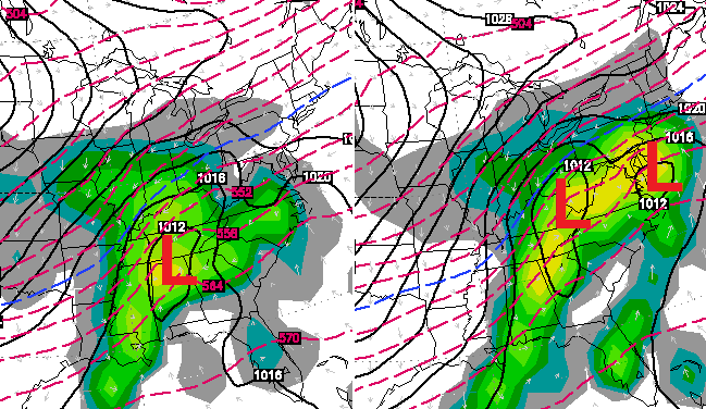
The 18z nam run just painted a real healthy swath of snow for Kentucky if future model runs continue to show this the NWS in Louisville one would think would have to include county’s bordering the south side of the river.
Yea, they are on the ball, aren’t they?
I said last night I fully expected this to trend north….said it again this morning. Guess what each run has done?
The trend is our friend this time around.
NWS in Louisville im guessing wants to see a few more runs and let the evening and overnight shift decide on how they will treat it. My guess WWA and if needed as the storm evolves upgrade then if warranted. Wouldn’t shock me to see WWA criteria for northern Jefferson County while southern Jefferson County meets warning criteria. A real tight precip gradient/cutoff.
for the first time here in Louisville, the northward Trend is in our favor.
we have pulled some upsets this year via overachieving and backside moisture.
some people dream, I say why not.
You go Chris, you are the best, funny how some folks said flurries yesterday are now waking up to what you have seen for days, love it, bring on the snow and will watch others play catch up 🙂
Thanks for providing factual and consistent info Chris!!! I’ve been following you since the ice storm a few years ago and have since found your consistency and honesty to be refreshing and greatly appreciated!!!
I know that your job is a thankless one and your true professionalism is rare…Thank you for your time and all that you do for us:-)
Love it Chris…can’t wait to be around when you open that can of “woop woop” haha.
I know I post every day practically about how fun this month was going to be. But, I can’t help it. February 2014 won’t be soon forgotten.
Have faith all you gloomy raincoat wearers. You will get your snow, your ice ice baby and everything in between.
Just buckle up. This pattern isn’t for the weak. 🙂
COOL POST 🙂
I would think some of that would be directed to MW on WDRB
Haha…hmmm
Chris, don’t worry about drama. Rise above such and leave off your comments to them. Kill with kindness is what my mom always taught me and now I know she learned it by our true leader, God in heaven.
thanks Chris!
nice work and never mind the negativity. you’ve been right more often that the other Lex mets and I appreciate that you explain all the possibilities and do stick your neck out on occasion.
a couple of my Grandaddy’s sayings come to mind:
“Takes All Kinds To Make A World” & “Misery Loves Company”
you’re like old school forecasting instead of just spouting the latest favorite model or trend.
and how ’bout them Cats! nice work young men!
Just noticed wsaz and the weather channel have issued winter storm watches for northeast ky ( and other areas of ky) beginning around 7pm Sunday until 10 am Monday….3-5 inches of heavy wet snow with a possibility of ice. I believe Chris beat them to this. Anyway everyone get ready.
The only entity that can issue weather advisories and/or watches or warnings is the National Weather Service.
The Weather Channel, other private weather firms, TV stations — they can only report what the weather service has issued
Carter county now has winter storm watch issued from Charleston if you followed Chris when he was in Huntington area you should remember his frustration waiting for NWS to issue a watch or warning. Just appreciate Chris and what you gained as a great meteorologist in Lexington. Don’t make a big deal out of forecast. Be grateful or find something else more constructive to do. If you don’t always agree find but no point in always be critical. Say something nice or not at all. You can think a different forecast but its rude to criticize others work. This is only my opinion to several posts but try to do to others as you would like to be done to you
Thanks Chris!! I go to your twitter feed before even looking at the station’s forecast! You are my weather guru!!
Well, NWS Memphis and NWS Charleston WV have finally filled in the gaps with a WWA and WSW (watch) respectively.
Let’s hope there will be no Ice Storm Warnings.
This.
Hopefully not a trend. NWS Tulsa has an Ice Storm Warning out for a few counties in Oklahoma.
Winter Storm Warning now out as far east as north central Arkansas.
With all the rain coming a few inches Sunday night could really amp up the flood concern with run off
More concerned with this
While I do share your concern, I’ll take flooding rain any day of the week over ice/freezing rain which could leave many without power for an extended time.
smooch smooch kiss kiss lol
Looks like Harlan and the other border counties are missing out this time… we’re looking at a mainly rain event. We got our snow earlier this week, though, so I suppose fair is fair.
To those who do get snow: enjoy!
Bubba – I’m with you………..Temps are warmer than forecast today, as they have been warmer than forecast in the past…….so then, wouldn’t it stand to reason by that alone that they would be warmer than forecast for tomorrow based on that alone? Or no? I’m just wondering….not bashing that’s for sure 🙂 It feels so good out right now!
Would like CBs perspective. Each time I have brought this up and each time the concern was correct. Stands to reason should be ditto for this event as well, but a CB slap down of the concern would be respected 🙂
Lol… today has no bearing on tomorrow. Colder air seeps in then crashes in during the evening. Somebody’s gonna get a smackdown snow from this. Will it be you? 😉
I’m sure hope it’s greenup county! Looks like we will be right in the middle of it!
Probably north of Bubba ice on Bubba’s area and rain south 😉
Ooh that’s harsh Andy lol
I’m not wishing it on him LoL
My logic is this Bubba always says the river is the reason he gets just ankle biters so since he is in the hotspot for this system logic would say it would move north and put him in the ice snow in Lexington and rain south of Richmond 😉
I’m pulling for you to get a big snow, Andy.
Thanks Chief i will be waiting
Can’t get over the tremendous northward shift in the axis of heavy snow today according to NAM. I was expecting this run of the NAM 18z to have already figured it out. I don’t know. Overcompensated?
It should have been expected
Please oh mighty weather wizard,send a foot of the white fluffy stuff Andy’s way. Lol….good luck Andy,we are rooting for you buddy.
As long as I get enough for snow cream…I will be happy!!!! 🙂
No the front coming through tomorrow will drop temps.
actually Tuesday I believe the temperature here in Louisville was colder than forecast
anyway prelude have you seen the 18Z GFS forecast snow map.
For tomorrow night snows? I have, not as robust as the nams. But GFS is showing a potential freeze rain issue for SE Kentucky. Some of the Hi-Res models are showing hefty snowfall for Ky for tomorrow night. Alot of model differences on snow amounts 2-6 inches seems fair.
Thanx
Absolutely amazing day to get out. Temps were warmer than forecast, which made for some fun hiking. With the impending storm on Tues/Wed bringing a lot of precip I hope tomorrow’s snow totals do not get too high. It could get really messy with floods later in the week. From the look of things, though, we may be in for a big time snow.
Thanks for all you do, Chris! I appreciate your hard work. 🙂
Appreciate your work Chris. I do check other weather sites but I trust yours the most.
Who knows what we’re gonna get with the Tuesday storm? Models pointing to possible heaving freezing rain event along the Ohio River. Paducah NWS afternoon discussions says to discount freezing rain “due to too much GFS tendency to predict freezing rain” and instead thinks sleet and snow will be more dominant. Long winter of dry cold unpredictability in my neck of the woods.
I pay no attention to the others, Chris! As far as I am concerned, you’re the only weather guy in town!
You Da Man ! Appreciate what you’re doing !!
Even though you left us here in Huntington WV country you still have many followers. No one beats your forecasts. No one. Usually we can get an idea of what will be coming our way better from you. We do miss you.
Thank you for all you do Chris!!
it is greatly – greatly appreciated!!!!!!!!
It was such a nice day today. Was wondering about tomorrow and get on here and see this. A little concerned because these types of events are the type that lead to our big problems here. Ice and power outages followed by the unexpected huge snow.
I am of the mind that the nice temperatures today would help but it did not really the last 2 times. And it really does seem a nice warm-up is what leads us to big events.
Think I may just get some extra fuel for the generator just in case. If I do not use it my husband always needs gas for the mowers and weed-eater.
The other local mets are calling for a mix tomorrow night. Did not see snow maps, but generic “mix” and “some snow” forecasts by them.
Will they look silly again?
No that would be the folks that put out a wsw the say all rain except for 2 hours then a slight chance of snow. LoL
Hard to believe I’m grilling steaks tonight and waiting for snow tomorrow.
Today’s warmth murdered our snowpack today in NKY. Deep drifts and snow piles from all the plowing are all that remain. The rain tonight will be great to get rid of all the salt.
Glad that the rest of KY is finally getting their share of snow, of course we are now on the northern edge of the fun tomorrow! LOL
the southern snow trend is not your friend, you folks up that way have had plenty anyway!
Have had enough, in my opinion. I say let it all pile on rolo’s house if we can’t have an early spring.
yep, Bailey and Rolo told u,. even a blind squirrel finds a nut evernow and then when it comes to me.lol but as I stated few days ago the trend of last decade was being busted as far as winter goes. OLD SCHOOL FEB/MARCH folks.
Let us know when it happens cause it shure hasnt yet ole buddy
Still waiting on that Rolo. lol Less than 3 inches for the year in Knox Co. Dome still holding strong down here at least.
http://www.weatherforkentucky.chatango.com/
come on in and lets chat about this “STORM” and stay updated with Chris Baily.
It won’t let me send a message 🙁
Thanks, Chris, for all you do as our weather guru, providing us with good info to keep us safe.
IF you believe the last couple runs of the NAM that heavy snow band is to far south and east. NAM has the heaviest snows lining up along the river from Paducah to Louisville. Surprised NWS Louisville has not put out some sort of advisory
You said Nam twice ??
It is not like these things have stayed steady 12 hours out, yet alone 24 😉 Track record of models panning out ain’t exactly an A rating.
I am now officially using the CB traffic meter for this expected event. Steady posts and updates, things are on course or even better. Time gaps have a strong correlation with bad news. That is unless you do not like snow, then I guess it would be good news.
Chris has gone silent, But the NWS is on board so who knows!
He isn’t silent on his twitter.
If the 00Z NAM turns out to be correct; who needs the Tuesday storm. We’re going to get pummeled.
southern folks will get rain and northern/central folks will get snow/ice
True that. Wish it could be all snow or rain, but this is Kentucky.
How much snow is the NAM showing for eastern ky?
Michael, can you post a link to that OOz nam run? Thx
Basically the NAM showed Western Kentucky up through Louisville getting about 4-7 inches of snow.
Remember that is just one run of one model.
You are correct sir. Never trust a single run. There are times when you cannot trust a trend.
Yes please!
00Z 2/2/14 NAM — 03 UTC MON 2/3/14
http://mag.ncep.noaa.gov/NCOMAGWEB/appcontroller/Image.php?image=data%2Fnam%2F00%2Fnam_namer_027_850_temp_mslp_precip.gif&model=nam&area=namer&storm=&cycle=00¶m=850_temp_mslp_precip&fhr=027&group=Model+Guidance&imageSize=M&scrollx=0&scrolly=0
NAM 48 HR Precip (Including rain tonight).
http://mag.ncep.noaa.gov/NCOMAGWEB/appcontroller/Image.php?image=data%2Fnam%2F00%2Fnam_namer_027_850_temp_mslp_precip.gif&model=nam&area=namer&storm=&cycle=00¶m=850_temp_mslp_precip&fhr=027&group=Model+Guidance&imageSize=M&scrollx=0&scrolly=0
For those of you wondering where the cold air is while Lou is at 58F, Fort Smith, AR is 37F
Looking more and more like a complete miss for far SE KY. NWS way have made a good call after all by leaving us off the WSW and may not even require an advisory which is fine by me. While it is quite miserable, mostly rain for us means less chance for ice.
Interesting tidbit…forecast low for my area tonight was 38 and it is already 35. Could this be the anti-Bubba and the colder than forecasted temperatures tonight mean colder than forecasted temperatures tomorrow night?
I would be more concerned with the trend of the track. At the rate it is going, it could end up a north KY and points north event and miss most folks with just some scraps. If ICE, I would be very happy with scraps, thank you 🙂
Good point Bubba. Seems the track is shifting northward by 50-60 miles with each run of the NAM. If that continues, it could track into Indiana/Ohio before it hits. Something to consider…..
If the trend is “real”, seems more a shift north rather than an overall expansion of the system. A gain for some would be a loss for others. Unless ice and then vice-versa 😉
One would think that might be a factor, but “usually” the arrival of moisture bumps the temperature higher.
52 in north Richmond ATM, so everything is relative 😉
The National Weather Service in Louisville, KY has added new counties to the Winter Storm Watch.
http://forecast.weather.gov/showsigwx.php?warnzone=KYZ030&warncounty=KYC111&firewxzone=KYZ030&local_place1=&product1=Winter+Storm+Watch
In addition, NWS Paducah now has a Winter Storm Watch for most of its coverage area, including all of western KY as well as parts of southern IN, southern IL and southeastern MO.
North central Kentucky all of the sudden in the sweet spot. Go figure. Louisville looks to get a real nice thumping. NWS in Louisville looks for a change over to snow sometime after 11am.
Question is would this be an expansion, or a general sift to the north, so folks to the south currently in it would get removed from the WOW and get a WWA. Or a WWF, MMA, NBA, NFL or any other acronym that seems fitting.
MLB,NHL,CFL & AEIOU and sometimes Y
They have added Louisville to the WOW and it also appears the storm will be in sooner that sunday night? I was under the impression it was to snow until Monday morning. WDRB just acted like it would be done by midnight tomorrow. The 3-6 circle from them had Louisville at the northern edge with nelson county at the southern edge. Crap I gotta drive through that 3-6 band tomorrow.
WOW should be winter storm watch. I gotta disable auto correct on my phone.
If we build a good snowpack from tomorrow’s storm, could that mean a colder storm for Tuesday/Wednesday? Would much rather get slammed with snow than rain/ice/mix. In Owensboro here.
Snow has a tendency to beget more snow.
Which is more reliable the GFS or Nam?
as of late the NAM
Tough to call. The storm we had before the first episode of the Polar Vortex, the NAM nearly nailed on the head. It was warm, but the actual air temps were warmer than it forecasted, due to a secondary low forming to the nw of Louisville. This produced a surge of warm air from the south. If I had more time, and ink in my printer, I would start keeping track, both during the warm and cold months.
It missed quite a few folks outlooked too, so nailed it on part of the head 😉
Indeed.
Northern Kentucky hogs all the snow. Let’s share the love for crying out loud. 🙂
Brian goodE, reported that the GFs is a little warmer and less moisture.
heaviest snow banDs 40 miles south of Louisville.
No that’s not what he said the heavy snow band looks to be 40 miles wide. Where the band sets up is what needs to be figured out.
I went back and read his update.
you’re correct
sorry about the misinformation
I try to be as truthful or print reliable information on this blog site.
again I apologize to all the readers
Brian Goode never mentioned this snow 24 hours ago, be carefull who you listen to, as stated by Chris, the master 😉
I will believe it when I see it… (when I say this we usually get no snow…) *fingers crossed* 😉
THANK YOU for all your hard work Chris!!!
Chris we need a update on your thoughts, do we have to wait till 1:00 am ??
Yes! 🙂 I like to look at everything before updating. Likely to bump up totals a bit.
You need to add a “like” & “edit” button
I wish I could have liked this comment!
In spite of your ice tweet?
We love ya, I’ll stay up as long it takes;)
Being on high alert mode for milk and bread sucks. Snow/ice sucks 🙁
Tomorrow night gonna be Beer & Wings… It’s Super Bowl Sunday..!
Yummy… Love wings.. Not a drinker, but I do like Corona with a lime from time. I’m making a 7 layer Mexican dip and deep fried banana peppers for our Super Bowl Sunday shindig 🙂
And Barb trumps my Beer & Wings w/a 7 layer Mexican deep & fried banana peppers… We’ll played
*dip
Like I said, an edit button is needed…
but on the positive side , I’ll have a reason to cancel my dreaded Monday dental appointment 🙂
Like! Even though you don’t like snow you are cool in my book 🙂
I try 🙂
Was hoping this was going to be a good one for us in the far south eastern corner but I am beginning to lose faith. Looks like mud and rain
Any chance that this moves further South?
Chris keeps saying the Tuesday storm is getting colder and colder
Rainy days coming to seky
Ugh…staying up to wait for an update. Too many times have gone to sleep hoping the dreaded “trend” shift doesn’t happen only to wake up to see Mother Nature reach down from the north and pull our low away. I want snow. Big snow. The walk out at dawn in soft silence without subzero temps and hurricane winds beautiful kind of snow. It’s been so long.
Southern Jefferson co and about 40 miles south and points east looks to be the bullseye for the heavy snow. I-64 corridor just a sminge south. My best guess.