Good Super Bowl Sunday, everyone. We are now in full blown Winter Weather ALERT mode through early Monday. Significant amounts of snow and ice are likely for many areas during this time. This will have a big impact on Super Bowl parties across the region.
Let’s break down how this system looks to play out…
– Heavy rain will be with us through much of the day. This is along a slow moving cold front moving in from northwest to southeast.
– Some light freezing precipitation may develop across the far west and north late this morning into the afternoon as low-level cold air settles in.
– Temps will slowly drop from northwest to southeast as the front inches through. A developing area of low pressure will then work to our southeast Sunday night and Monday morning.
– Snow and freezing rain will take over this evening and continue into Monday morning. We are likely to see a heavy band of snow setting up from southwest to northeast. We are also likely to see a decent amount of freezing rain developing in the south and southeast. That should cut into snow totals in those areas, but may create even bigger issues because of ice.
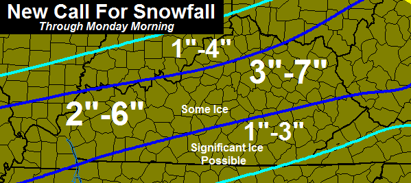
– Here’s my latest map on the possible snowfall…
Looking down the road to the Tuesday storm… I continue to believe we get rain, ice and snow from this. We are seeing a definite trend toward a colder solution with that storm on the latest models. Ice is a real concern for central, northern and western parts of the state especially. Let’s get rid of this storm and see how this thing plays out from there.
Here are the tracking toys for today’s action…

Current temperatures

I-75 @ Winchester Road
Lexington

I-75 @ Iron Works Pike
Lexington

I-75 @ Clays Ferry Bridge South
Between Lexington and Richmond

US 60 @ US 127
Frankfort

US 127 @ Frankfort
Frankfort

I-75 at MP 36
London

I-71/I-75 at Buttermilk Pike
Near Covington

I-64 @ 3rd St. Exit
Louisville

Downtown Louisville @ 2nd & Broadway
Louisville

I-65 @ 234
Near Bowling Green

I-24 MP 4 @ US 60
Paducah

I-24 MP 7 @ US 62
Paducah

Updates through the day, so check back. Take care.

Looks like I’m in the sweet spot 🙂
Chris..do you think we will get above freezing on Monday…a chance to melt whatever Somerset ends up with :-/
I love it when the tracking gQQdies come out. Happy Groundhog Day! Don’t kill Phil if he see’s his shadow. Enjoy the Super Bowl; Go Broncos!
Fun drive coming home from work tomorrow. Thank God for four wheel drive.
Slightly confused on your placement of the heavy snow band given the current model trends, but I still respect your forecast.
He’s the meteorologist, I think he knows what he’s doing
Chris, I am your biggest fan. Thank you for all this snow.. I know this is all you
I am in the 3-7 so I will hope it works for the 7 or close. Even weather.com is now saying snow for my area. It is crazy how much they have changed it so quickly.
And please no ice.
Maybe I overlooked it but I don’t believe CB mentioned anything about the groundhog? I thought this post would definitely have a picture Puxatony Phil. Forgive the spelling
Punxsutawney. You were close. lol
Lol, just a few letters off.
Looks like ice and 1-3 inches of snow for me. Will take the snow but the ice, DON”T WANT THAT!! lol
Be safe everybody!
Hard to believe. This storm may become bigger than the BIG storm, at least for our region.
Snow and ice forecast amounts look to be updated frequently until changeover actually occurs.
06z RAP shows changeover in Louisville by 5pm to at least a rain/snow mix. Accumulation though not until at least 7pm.
850mb freezing line just south of Ohio River near Louisville by 7pm, perhaps cold enough for all snow for Louisville by then.
This is as far out as this model takes me (18 hour).
I’m sure even the short-term models like this one are going to have various differences from hour to hour.
Forgot to mention but by 7pm, 925mb (approx 2,500 feet above the surface) readings are even colder, showing freezing line well into central KY. It’s going to be interesting to see how surface temperatures fare by then for north-central and central KY with precipitation in the region because this run suggests a period of ice before snow for some.
I think its weird that NWS has only given us in Pike Co. an Advisory since we are suppose to be in the area for significant ice. And we all know ice is worse than snow.
The 6z run of the NAM says what snow?
What do you mean?
Overlook them, they cheer for Louisville.
That was unnecessary.
Nothing wrong with what was said. Go have your coffee and turn that torch down 😛 I want my snow
I am used to it. Most of my friends are UK fans. No one could say any worse than what they do.
Thicker skin please, that was obviously a jest…
Upgrade to Winter Storm Warning for Louisville, Lexington, Richmond, E’town, Frankfort, Jackson, Morehead.
This has bust potential as we get closer. Remember a month or so ago when a WSW was issued for the metro and then cancelled a short time after? The NWS giveth, and the NWS taketh away. Model waffle this morning for breakfast.
So far, the short term model, Rapid Refresh, continues to show Louisville in an area of moderate snow for several hours. At least 2-4″ still looks on the table for Louisville, perhaps more.
Mike I hope you are right. I have a new action cam and am ready to use it.
Looks like we’re in a winter storm warning
Looks like us here in Laurel County have been moved from WSW to WWA mostly rain little ice or snow maybe next time
Hello all. Never posted but have watched Chris B’s blog for years. I live in the southern end of Logan Co and it seems like we live under a dome when it comes to winter precip. Hopefully we can get in on some of the snow action before this event is over. Would love to see 3 inches plus. Good luck all you snow lovers and may the freezing rain stay away for us all.
Looks like Southeastern Ky and must of east Kentucky will be shut out of the snow.. I’m thrilled, wasn’t looking forward to any snow.
Payback is coming Barb 😉
lol.. not my fault Southeast ky isn’t getting any snow..haha 🙂
it might be 🙂
This time around, I’ll have to say that I am right there with you Barb. The lesser chance of snow = the lesser chance of freezing rain and ice. I also wouldn’t be surprised to see that division between WWW and WWA move farther north throughout the day. Remember, the track of this thing was looking to be in East Tennessee just over a day ago and has continued to move north by 20-40 miles with each run of the NAM.
Sure hoping we don’t end up with ice.Guess I need to go buy more salt.
Really wish that Laurel County traffic cam was at one of the I-75 exit ramps or near town so there would be some lighting.I can never see any weather in that cam because of darkness.
Just rain for London.
Your right the cam used on I 75 just before the scale house is awful must not be able to access the cams at the exits
Phil didn’t see his shadow this morning.
Yes he did.
Well the groundhog in my backyard didn’t see his shadow.
did you shoot him before he had the chance? LoL
Fail
Phil indeed DID see his shadow.
Wishful thinking.
Phil did see his shadow. FACT
http://www.usatoday.com/story/weather/2014/02/02/groundhog-day-punxsutawney-phil/5101379/
Andy my friend, I think he’s saying “he’s” wishful thinking… Lol
I really hope you get a big snow Andy, you’re starting to scare me…
lol
Was hoping for some snow love in London.
*Yawn* morning
Morning bloggers!! How is it looking this morning?
Depends on where you live. Either way the rich keep getting richer
Again…Laurel County is “the line.” Still good for us school kids…northern part of the county gets slammed, southern gets nothing, but we’re out of school until…… Anyone want to volunteer to take the ice away from KY?
BTW, Bowling Green, Louisville, Fr. Knox, Frankfort, Covington are already behind the front with N or W winds and dropping temps. Would this be an indicator of more cold air moving in faster that once thought? Could that be a state wide trend, kicking the ice south?
The wife and I have to go to Richmond from Lexington around 5:45 until around 8:00. Does anyone have an idea when this stuff is supposed to start in these areas? I would like to give as much notice as I can to cancel our plans. Thanks and everyone be safe.
That looks to be real close to your “transition” time. Temps will be marginal, so interstate will stay clear a bit longer than side roads until the heavier snow bands set up. I would keep up with the trends and movement of snow through the day before you leave. Be safe.
blurrrrrrrrrrrrrrrrrrrrrrrrrrrrrrrrrrrrrrrrrrrrrrr
put your goggles on Rolo
thanks Chris.
dark, rainy morning in Lexington.
temp looks to be 48 degrees out back.
looks like some fun tracking – think SNOW, not ICE.
have a great day all!
Go Broncos!
http://twitter.com/search?q=%23kywx&src=typd
Thanks for the link Barb. How much are they calling for in your neck of the woods?
So here in middlesboro we should expect heavy rain? Then it cooling to 36 in the morning and a col rain? Sorry guys just don’t think it’s the right track for us… We get no where close to 3″ looks like maybe a dusting
Fine by me,,,,better than ice that was predicted earlier, not to mention, had we gotten snow. it would have melted off by Tuesday morning at the latest with highs Monday at 46 and Tuesday at 50 degrees.
Wonder why the temperature map on here isn’t working ?
the code may not have been input correctly when he made the post because the Mesonet site is working
Chris, I know you only forecast it, but I sure wish the weather gods would smile on southern and southeastern Kentucky for a change. We’ve seen so much rain and now it looks lithe more and ice for us. Oh well. Post pictures everyone. Don’t want to forget what snow looks like! ( our luck is so bad we even got taken out of the watch area.)
Maybe next weekend Coffelady.
Balmy 41 degrees on top of the hill @manowar and tates creek. Anyone have any idea when the front is going to move through today? Have an eventful day planned and elderly parents who i dont want travelling in this
Same ole same ole in
Somerset. Would take plain rain over ice though.
I would like to know why every county around Lawrence County
has a Winter storm Warning and Lawrence is under an advisory?!? Can anyone give me an answer for this one?
12z NAM coming out now and it slams central Ky with an old school snow storm tonight and tomorrow. IF it does verify, Chris will have to up his snow accum. forecast. Can’t wait for him to see the NAM and tweet about it.
Given the “someone’s going to get slammed…hit hard…big snow…” sort of language that CB has been throwing around here and on Twitter the last several days, one would expect more than a paltry 3-7″ that’s on the new map. I hope the new NAM provides a bailout to back up those heights of description.
Honestly, as much as I love snow, I’d take all rain to avoid the ice entirely.
Hmm, noticeable little red blob moving across northern Madison. I hope that only looks bad on radar.
James is right. A foot of snow is what was showing. The thing is though 3 straight runs it has been showing something different each time. First the heavy snow moved north to Louisville, the next run showed very little snow for anyone,and finally this run shows a foot of snow. To be honest hard to trust anything it’s showing.
It is a good bet there are going to be some angry Dish and DirecTV customers tonight when their Super Bowl loses connection from the heavy wet snow.
I just hope I’m not one of them…at least until the Super Bowl is over. That’s not being too picky is it?
I already got my ladder out and towel handy.
So, folks are now not only cherry picking models, but specific RUNS of the models 😉
The NAM though when closer to the event has been the more accurate so far. The more data the models have, the more accurate (I mean that loosely) they should be- the closer to the event.
Point being: Model runs from yesterday or many hours earlier should (in theory) be less accurate than runs within ours of the apparent event. Should be- not will be.
I don’t really see any cherry picking going on. He said “If” it verified. I clearly stated it was hard to trust it.
I was referring to posts in general. The Cards should be fine this year, so chill 🙂
You must not have seen UL play much. Not that good.
Same record as last year at this point. On a tangent, got to admit the Duke & Cuse game last night was impressive. I dislike both teams.
It might be better to use short term models like High Resolution Rapid Refresh model or something similar at this time.
I think somewhere between Louisville and Lexington will be the sweet spot.
Could you provide us a link to look at it James?
Tried to copy and paste link, but my phone won’t let me for some reason. Sorry. Can anyone else post it?
Looked at snowfall forecast for 12z NAM and it showed a 12 inch strip from south west of Lex, through Lex, then going north east of Lex. To the Ohio/WV border.
So greenup is in that strip?
Temp down to 35 in Lawrenceburg already. Temp profiles looking good–now just time for the precipitation to play nice.
IF this pans out, a mix of ice and snow is an awful combo for shovel efforts. Half empty view is every time ice is part of the forecast, it tends to cut into totals for a large part of the map and the top third or higher north- gets mainly snow for the totals and less ice.
Better have the ole back brace on.
The Nam sure turned into quite a monster on last run…
Question for Jackson NWS, you mention warm ground temperatures being a factor in accumulations, well, I live in Southern Pike county and my ground is frozen to a depth of around 4 inches, even after the warm temps yesterday, so where are these warm grounds at?
I agree. Here in Phelps I still have snow on the ground from the 8 inches a week ago. Dont see ground temps playing a part in the accumulations tonight
Que sera…..sera. It’s all good.
temps dropped to 40 since last on…Lextown.
this is going to be fun!
whatever happens with this storm-it’s a bonus.
think SNOW
Got a quick question.
since we will have a snow pack on the ground from Louisville to central Ky, will make Tusddays storm track farther south? I had heard someplace the a low will follow along the edge of a snow pack
Please correct me if I am wrong.
sorry for the typo, Tuesdays
So just to show how worthless Accuweather is… We are less than 12 hours from this event beginning. Their forecast for Danville tonight is 0.11 inches of snow with 0.0 inches tomorrow. Maybe Chris or someone can explain how their computers can come up with something so far off base what everyone else is saying. Exactly what model are they using to be so far off almost every other model?
Cracku-Weather is an excellent source of current weather conditions….. lol..totally worthless.
Here’s the latest NAM 12z map just for fun, to 48 hours. Someone correct me if I’m wrong.
http://wxcaster4.com/nam/CONUS1_ETA212_SFC_ACCUMSNOWFALL-KUCHERA_48HR.gif
JUST a model, not a forecast, right? lol
CB mentioned it too. If this run trend holds, expect a total increase from CB, but the catch is the ice factor. A heavy wet snow and ice mix would smack areas hit, real hard. Power issues would be a key concern if pans out.
Will be interesting to see CBs next post and how much would ice be a factor for folks.
So, since we are within 12 hours can we start thinking the models are a “forecast” now? If so, the nam run is insane for mercer county.
The NAM has been the more accurate, but still off for what the results have been. Perhaps a blend of the current GFS and NAM are a more likely solution. Catch there is the GFS has a wicked ice mix for the southern areas.
CB must be on overdrive at the moment trying to nail this down.
I bet smoke is coming out of his ears. Agree on the average of the two but ice anywhere with those totals is bad news, isn’t it!
I bet he will nail it down. I am still amazed at how far out he pegged the last snow system for our area. I know he is skilled, hence why I have been following his blog for years. That was amazing how he pegged it and also the start to February.
12z NAM from Jackson
http://wxcaster.com/gis-snow-overlays.php3?STATIONID=JKL
12z NAM from Louisville
http://wxcaster.com/gis-snow-overlays.php3?STATIONID=LVX
I won’t put my money on the accuracy, but those maps sure are sweet to look at!
I think the NAM has proven before within 24 hours, it has historically, overdone it. Also, you cannot really tell how much snow falls with this system based on the 84 hour map.
GFS not as juiced up as Nam..Gives Eastern and South East a bad ice storm..
This is a good point. Is there enough moisture to produce what the NAM is outputting? Based on CBs current map, a blend of the current GFS and NAM fits.
http://mag.ncep.noaa.gov/data/gfs/12/gfs_namer_021_850_temp_mslp_precip.gif
http://mag.ncep.noaa.gov/data/gfs/12/gfs_namer_024_850_temp_mslp_precip.gif
Holy smokes batman. Just looked at the nam. In mercer we are in 12-14 inches. Anybody got a link to the gfs?
I live in Mercer also… Look out !!!
I know….i know it is just a model run but good grief, even if we got a half of that, six to seven inches with a little ice may cause some power issues.
folks better recheck that freezing line
🙂
YESSSSS Lexington and Central ky is going get hammered … Take that Eastern Ky , Southern Eastern ky and Southern ky. About time we get out big know. Makes me happy that EKY and Southern KY is being left out… I’m only playing guys .. lol
That’s just rude! lol I’ll remember that “if and when” we ever get a 12″ or more Tennessee slider (southern track storm moving from West to East Tennessee, that still throws big snow to southern Kentucky)) that would leave you guys shut out in the cold. lol 😉
Smack talk usually backfires. You probably just jinxed this! Now all we need is Rolo hollering, “Oldschool!” to seal the deal of snow repeal. 😉 🙂 😉
Frankfort seems to be the best spot.
they might not receive the majority of the snow. but it looks like they are going to receive good hit
Central and Northern Kentucky has been the sweet spot for snow this year. Southern and SE Kentucky missed out on everything and this one looks like it will be the same. Hopefully we stay out of the ice. Would much rather see rain. Enjoy your snow. Might be a dome buster for you guys if the NAM proves correct.
I wish it would start now and maybe keep folks off the roads later when it gets bad.
***EVEN THE ACCURATE RAP MODEL*** within 8 hrs of an event always does well and even it puts down over a foot of snow across the area. I GUARANTEE you Chris will have a 8-12″ stripe in his next map update.
which areas
i highly doubt it chris changing his call much at all
I-64 corridor and points south are looking at problems. Southern Jefferson county and points south and due east is all fair game for a big snow.
Love seeing all this data people are posting. Awesome stuff. I am not in the biggest snow area on some of those but close. Some of that looks icy though for farther SE. Not quite as far SE here but still close enough. A little shift and we could be in trouble here. And I do not want that for anyone.
Need a way to pull it to the south. Andy needs a snow bad. And a decent one. I had mine. We had 8 inches at my house from one of the last snows. We had 2 inches left after all those warm days and it finally started really disappearing yesterday.
Also very interested to see Chris’ next update. Hopefully he can give a little insight on the next event as well. How the models are trending and his thoughts so far. If I get a snow and it warms up decently then rains that is not as big a deal as if the next system is trending colder and ends up with more snow and colder.
NWS has my area in the 8-10″ range. That’s highly unusual for them to go over 4-6″ for our area!
where did you see this?
NWS.NOAA.GOV I clicked on the story that says heavy, wet snow expected and it brought up a snow map. Here’s a link; http://www.crh.noaa.gov/jkl/?n=winter_overview
Chris anxious to see your next update. Hope the snow is trending more south and we get snow instead of ICE. We want SNOW too!!!!
Not had a good snow this year in this area. Would hate to waste a cold winter with just a little snow.
http://www.instantweathermaps.com/RAP-php/showmap-conussfc.php?run=2014020215&time=INSTANT&var=SRATEI&hour=014
Latest RAP snowfall rates for hour 14… 2.0+ inches per hour rates in the purple around Louisville
Holy shnikies!
This has potential to be shut down storm.
48 hours ago this bad little boy was in infant stages. Not even thought of by most.
Well, check out how fast it has grown. Those radar returns in Oklahoma, Arkansas, Texas are quite impressive.
I would not buy that for a dollar as far as such a specific area, this far in advance 😉 Question though that needs an answer, is it shifting north, or an expansion of the system overall? Seems it would be more of a shift.
CB is probably working on this right now. Key words probably could be “bands” and “sharp gradients”. Standard Fencetucky words for describing snow events 😉
Given the fact that this was a small inch or less event two days ago and blew up for the models in a day, seems plenty of wiggle room for all the above, almost anywhere in the state.
yes, I saw that too. It has been consistent in showing Louisville in a moderate to heavy band of snow for several hours. I know the model may show some fluctuation, but right now, it’s still showing Louisville to Lexington bearing the brunt of snow totals exceeding 4″. I wouldn’t be surprised by some 8″ amounts in that region if the available moisture is there.
Well of course the storm would trend more north. It just wouldnt be right for us folks in south central Ky to get in on the heavier snow action. Sigh.
Hey guy, I know I seldom post, but I read this thing like every hour when a storm is on the horizon. I just want to say that this thread has been what I think one of the best informative, and idea threads ever posted yet here on CB’s site. The different links to different models, the thoughts & ideas..I truly feel thats why CB started this blog, hang on to this spirit, I’m learning here and so is many more I am sure!!!
Is there a chance this thing could still shift and give South Eastern KY snow ?
I’m wondering the same thing. I am in Manchester and wonder will we see all rain, or ice or mainly snow.
hey there mr. bailey, we need an update….too many wannabe mets out there talking about shifts to the north or south and accumalations as much as a foot if not over a foot……..less than 12 hours until all of this should be in high gear……we need an update even if it is a small one.
This.
Two hours between tweets and counting….. Ruh roh!
So what exactly is this storm track called? Is this an apps runner?
Is there any chance at all that this will shift a little further south?? What is the expectations for the Manchester area, more ice than snow or what? Thanks for any input! 🙂
Well here in Southeast Ky. looked like we on the tail end of the action. But now I notice all of Northern Tennessee has advisories too…some for ice and freezing rain….So hang in there Andy lol things may change 🙂
NWS now has Morehead 6-9… I’m a little nervous of the ice potential.
The Ashland area is having horrid water problems. Thousands without water and even more with boil advisories. Ice and hevy snow have the potential to create further problems –2003 I was without water for 7 days because of power outages at the pumping stations.
Horrible news of more fire deaths this week (again this morning). Power outages also mean people try risky heating sources.
May this be a lightweight snowfall without ice… May we all be safe!
CB,need an update soon buddy. Lol. I’m sure you have had your 2 hours of beauty sleep. You’re the man CB….disclosure…this post was meant solely for light hearted entertainment purposes only. Not intended to offend anyone. No animals were harmed in the making of this. I in no way endorse my own thought. I am simply under the influence of the potential of a major winter storm. The writerof this post is not responsible for this comment….that is all….you rock CB!!!
lol 😛
Little bit of sleet falling in Elizabeth, IN
Nearly impossible to tell where the Freezing line will set up..Of course the more North you live the better chances of snow..My guess and only a guess is North central and North Eastern parts get the heavy stuff..You may live in an area that get’s 4 inches and drive 10 miles and see a foot..A 50 mile shift North or south in modeling would make a huge difference..Of course us snow starved folks in Southeastern Ky can only watch and wonder what we have done to see such misery..
Looks good for greenup county
I hate to be negative, as I often am when I post, but it doesn’t seem like we can catch a break around the Monticello area for good accumulating snows, always a few miles here or just a few more there. I will say this; if it’s a choice between ice or rain……. QUACK QUACK!!
If this won’t be a nowcasting event, I don’t know what is. Anybody and everybody is fair game. Good luck to all!
Here’s a meteogram From JKL..For us folks in Eastern Ky the GFS is our friend..The Nam not so much..Scroll down and look what the Rap is showing for ice..This is 11-1 ratios..Could be a big mess with possible snow and ice..
http://www.meteor.iastate.edu/~ckarsten/bufkit/image_loader.phtml?site=kjkl&nam=on&gfs=on&rap=on&ratio=11&mean_mt=on&max_mt=on&mean=on
rain and sleet here in athens oh temp down to 33.5