Good afternoon, gang. A major winter storm is pushing into the state this afternoon and will deliver a significant snowstorm to many. Ice will also be a problem for several areas across the south and southeast. Let’s get after it…
– Precipitation will continue to expand this afternoon as the cold air presses south and east. Snow will begin to break out in the west and that’s a trend that quickly collapses eastward into the evening hours.
– This storm has tremendous potential to produce heavy bands of snow that can put down snowfall of 1″-3″ per hour.
– A widespread swath of heavy, wet snow will be noted across the state. There could be a sharp cutoff to on the northern and southern edges of this and I won’t be able to tell exactly where those set up until we are in the middle of this thing.
– Here’s what I’m thinking…
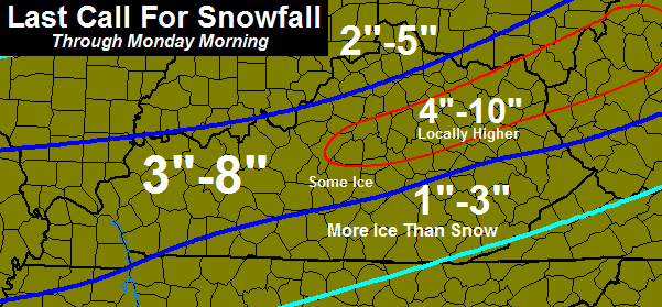
– My worry is some areas will exceed those numbers… I just can’t pinpoint where. Also, don’t just focus on the highest number. It’s called a range for a reason. 😉 I will try to tighten that up to account for the sharp cutoffs as we get into the event.
– This will be a heavy, wet snow that can create a lot of issues. Areas that wind up with 6″ or more COULD deal with some issues with trees and power.
– Travel will become terrible later this evening into Monday morning.
On a related note… Tuesday keeps looking uglier and uglier as we get closer.
I will have updates as needed and will be on WKYT-TV this evening. Take care.

Well Pike is still in the 1 – 3 range. Sure was hoping for more.
It all depends on hour much ice you get
Yeah still havent seen anyone say how much ice we might get
HPC says we have about a 35% chance of half inch or greater
http://www.weatherforkentucky.chatango.com/
CHatroom open come join me.
COLD RAIN here in Keavy with a temp pf 37.
Well, just pull it South about 30 miles and put the ice in Tennessee lol
Tennessee is already expecting ice and some snow.
“Tuesday keeps looking uglier and uglier as we get closer”
That’s in the eye of the beholder, please elaborate… 😉
Ice!
Please reconsider your answer…
Now that was funny! Ice, however, isn’t. Chris, maybe you can answer this: If we (Lex and surrounding counties) get a big snow tonight and end up on the higher end of your map, how can that impact the Tuesday system? I’m sure it’s too early to tell, but with a cold surface due to a large snowpack, wouldn’t that really ramp up the chance for freezing rain and ice? I’m not the expert, that’s why I turn here, but how much influence can a deep snow tonight have on the Tuesday system?
Vinny and Chris, those two comments made me completely laugh out loud!!!
I’m with you, Vinny. CB needs to wave his magic weather wand and bring more snow, NOT ice. Do not want to see the ice ANYWHERE! :/
I expected ice before this current system morphed into a potential mutant. That is a mega smack down combo. Ice on top of ice, and ice on top of heavy snow. A lot of us might be knocked into the dark ages for a week (on average).
Boo! to the lack of underground residential power lines.
One reason I bought this house in 2010 was the buried utilities. I did not want to go through another January of 2009 or February of 2003.
🙁
My neighborhood has buried utilities as well. Only problem is it’s fed by above ground wires. We were without juice for a Week during the ice storm 10 or so years back.
MikeM…It sure is sleeting out there now. Wish the snow would start! I fear icing!!
We have underground utilities also but have still lost power twice during storms in the past few months. Your only as good as the lines that feed you and, unfortunately, most of them are ABOVE ground. 🙁
Our underground utilities once were taken out by a tree hitting the line going into the ground.
Thanks Chris. Please move the snow further south. Don’t wNt ice! Stay safe everyone.
Thanks Chris! Your dedication to keeping us informed is second to NONE!
hey Joey are you guys receiving any frozen precipitation out there in Owensboro.
radar showing frozen moisture in the clouds
Yes, some sleet and snow falling
So Chris thinks we are in the 4-10 while NWS Charleston only has us in a WWA with everyone else around us in WSW.
Where r u?
Lawrence
Yeah I’m in greenup, they always leave us poor northeastern counties out lol
Always have always will.
NWS in charleston had a winter storm watch last night changed to a wwa this morning and now this afternoon a winter storm warning. Thankfully Chris doesn’t serve as many waffles as they do. Lol keep up the great job.
I really don’t need this winter weather right now, trying to go to EKU, I commute so I really don’t need to battle 5-8 inches.
They will probably cancel it because of the weather
How much ice are we talking about here in southern Kentucky, last year they said it wouldn’t amount to much and then we had an ice storm warning issued! Need to know how prepared we down here should be!!
Yeah It he keeps putting us in the 1 – 3 in of snow but still havent heard any amount for the ice.
Very little i would say. iF you look at our possible snow total mostly a cold rain with a little ice on the tail end.
I,too would like to know about the “I” word…like WKYT reported a day or so….Pulaski Co has enough road salt to fill JUST 3 trucks…..ooooohhh noooo :-/
Waste not, want not.
I bet nothing for Whitley. We can’t get a good snow.
Appears to be a blend of the GFS, NAM and obvious CB skills.
I would not be surprised by some 8″ amounts between Louisville and Lexington.
That’s the ticket! A nice snow pack to help thwart warm air aloft for Tuesday 🙂 Then again, the extra chill in the air may be what the surface “needs” to build the ice…..
Would be nice to see some scenarios from CB that factor in today’s event with the ice potential Tuesday.
Just need this sucker to push North about 10 – 20 miles and The Ville is going to get hammered. Getting excited… it’s trended exactly how it’s needed to all week, now it’s just gotta finish the job.
No ice please!
you got your wish of no snow so this is what we get THANKS BARB 😉 j/k
NWS louisville says this storm has great bust potential, meaning more snow or less or area of snow location?? Nowcaster!
That would be the cut offs that CB is not sure about. That said, if ice is the main player Tuesday, a bust would not be so bad.
I’m heading to Kroger and Rite Aid in a few. Should be interesting.
I hit Kroger at 12 and it was busy…but getting crazier by the minute…I went early to miss the after lunch church crowd.
If you’re in Louisville, WAVE3 Blog is live-updating the NWS conference call. Good info.
3-8 inch range in Butler County!!! Yet, still an advisory
Now a Winter Storm Warning for Butler County
Posted in other thread by mistake so I’ll repost..
Here’s a meteogram From JKL..If i understand it correctly for us folks in Eastern Ky the GFS is our friend..The Nam not so much..Scroll down and look what the Rap is showing for ice..This is 11-1 ratios for snow ..Could be a big mess with possible snow and ice..
http://www.meteor.iastate.edu/~ckarsten/bufkit/image_loader.phtml?site=kjkl&nam=on&gfs=on&rap=on&ratio=11&mean_mt=on&max_mt=on&mean=on
Wow…..this turned ugly really fast……..amazing how many other local mets have come around to what CB has been calling pretty much all week. Wonder what DarthBubba’s thoughts are today?!
Nobody called the one for tonight as it appears now. The drama was over the Tuesday event, since tonight’s was expected to not be a biggie. CB has always stated Tuesday could be ice, rain or snow (or all between). Now CB is currently leaning ICE 🙁
As far as DarthBubba, emergency maneuvers are being prepared to position the Death Snow Star away from a potential Snow Rebel force attack.
Also CB has more ice than snow in the Southeastern parts..Has 1-3 for snow..So if we get more ice than snow would we be looking at 1-3 inches of ice since we will be getting more ice than snow..Hope you’re not as confused as i’m am now..lol
LoL your funny but 1-3 inches of ice isn’t that might even stop me.
Fortunately, in the case of ice, you do not receive equal amounts of ice that you would snow. Consider that if a system puts down a total of 1″ of moisture, snow ratios are usually around 10:1, so 1″ of moisture would be 10″ of snow, while it would still only be 1″ of ice. 3″ of ice would be pretty unheard of 🙂
Hope you are wrong about the heaviest and it ends up being more in se ky. That 1-3 will probably end up being ice and rain for us. You can keep the ice.
56 degrees here in my part of Knott County. Hoping for all rain or snow…NO ICE!
You know some of these other local Meteorologists out there are stressing about Tuesdays system becoming a major winter event. I so hope it does. Hope they love the taste of egg on their faces. Lol. We be a big smack down to some even bigger egos…you go CB!!!!
Plenty of eggs to eat in Lexington with Wild Eggs coming soon.
Good eatin…really like the Fosters’ Banana waffle
Yes its very tasty!
I know someone probably already asked, but i m not a meteorologist. How can it snow that much when it is 50 degrees right now? I want to know out of genuine curiosity, I like to learn more about the weather and how it works. Thanks Chris always.
WSAZ said the storm system for Tuesday and Wednesday will be (and I quote) “All rain as predicted.”
Look at the source.
does it all the time during the spring.
it happens all the time in Denver.
I have seen it snow last Saturday and the next day it was in the upper 50’s.
the radar looks good snow line north of St Louis.
snow feeling up out west.
who exactly is the snow feeling up?
southern Illinois north of the Ohio River
Laughed out loud….
The ice/snow line is going right through Warren County and has for the last couple of maps. Does that mean that if we get ice, we will get heavier ice than the counties just south of us, or less ice and maybe a little more snow…
My 10 year old got a snow sled for his 5th Christmas and it has only been used in the mud. lol
If you are referring to CB’s map, that dark blue line through Warren County is more of a boundry between different amounts of snow than anything else, although it also indicates an increase of ice as you go south.
But the Weather Prediction Center is currently showing that the heaviest of any ice will be between Bowling Green and Nashville (roughly on the KY-TN line), so hopefully Bowling Green will get mostly snow and relatively little ice.
BTW, I’m a WKU grad, now living just down the road from you in Nashville. When I was a student, I and others once got pieces of cardboard and slid down the snow below Van Meter Hall 🙂 . Also, my wife grew up in Bowling Green.
12Z NAM Cobb Data #s for KLEX (Lexington). Snowfall 14.7″ (water QPF 1.38″ after .24″ of rain). 12Z GFS Cobb Data #s for KLEX; Snowfall 7.6″ (water QPF .76″ after .24″ of rain). If you blend the NAM/GFS, you are talking about .24″ of rain, and approx. 11″ of snow for Lexington. This is on top of any rain received prior to 2 p.m.
For anyone reading this post; these numbers are from the Cobb Data Table page, and in no-way are they to be taken as a forecast. This is to give everyone and idea of how explosive the models have become with there reasoning so close to the event starting. The above numbers are for tonight’s event only. Any precip from the mid-week storm is not included.
Chris, I monitor your blog, even though we live in Wayne county, WV. Since you left our area, we have not had near the good blogs and updates, nor have the forecasts been as accurate. You are sorely missed! Good thing about your blog is that your calls for severe weather usually expand into our area, which gives us a little more detail about what is headed our way. Glad to see your still keeping up the good work!
And while we are on the subject of WV…can you possibly give me an inkling as to when it will hit Wayne county??? Just any little tid-bit you can throw our way would be appreciated for sure! Our weather forecasters are treating this storm very mildly…and I’m not sure what to think here.
Looks as though the same area of the state that has gotten all the snow this year is once again going to be in the sweet spot. Congratulations. Hoping for warmer temps and dry weather here in SE Kentucky. Not much to talk about as far as snow down in this region this year. Time is running out and nothing promising this week. Have about three or four more weeks left and then the chances go way down.
It’s gonna get ugly tonight.
Could someone enlighten me on the arrival time for Winchester. I’m traveling from Winchester to Jackson and hopefully back to Winchester, depending on the arrival time of the storm.
this storm has nowcasting written all over it ,maybe as much or more than any storm this winter yet
this as a whole going to be a bust,
Why are you thinking that rolo??
Reverse psychology
Ahh ok!
It’s snowing in Evansville, not KY but right across the Obio from Henderson.
Now the Louisville area mets are on board with what CB has been predicting all along. I haven’t commented this season, but have been reading faithfully. Many thanks to Bubba, Andy, Todd, and others for posting often about the weather AND the witty comments! You guys make me chuckle often! Especially thanks to Chris for his relentless thoughts/forecasts!
Sleeting in new Albany Indiana and northwestern Jefferson county.
Sleeting in Louisville.
Have to say I’m on board with cb. Looking at many of the models there is going to be a small to moderate size area that is going to get the smack down. By smack down I’m thinking 10″ plus. I’m banking on a portion of eastern ky and west central wv being the prime spot. Either way this ones going to be fun to watch!
Anyone find it interesting that nobody really talked about this storm all week except CB. Everybody was mentioning the storms for next week and as it got closer CB kept reiterating his point!
People on here were mentioning that sometimes this big storms with the biggest snow amounts pop up kinda late and over achieve big time. This storm sounds exactly like that. Just interesting to me!
Thanks Mr. Bailey!!!!!
Radar looking juicy, this might be an old school Bubba Buster for some folks tonight 🙂
I agree…..dare I say both bubba buster and old school in the same sentence? Isn’t the change over happening a little earlier than initially predicted also?
I live just across the river from Louisville, Sellersburg, IN. Local guys are saying 1-3, maybe 4 for our location. Lookin at the radar trends, things are lining up well for areas north of the river. I would think they would have to increase the totals for Southern Indiana.. Anyone care to comment??
The HRRR has been trying to sneak a portion of the southern tier of counties bordering the Ohio River. NWS may just have to do a case by case basis as to warnings. Southern Harrison, Floyd may be upgraded, maybe the southern part of Clark.
It has already changed to snow for us here in Floyds Knobs, IN just across the river from Louisville…
Thanks Mike S, yeah that’s what I was thinking as well. Lookin like heavy snow starting to set up right along the river..In time that will shift more east instead of northeast, but still looks like heavy snow for all counties just north of the Ohio…
Mike S I am in Harrison county IN and nothing but an advisory at this point I wonder when they will update.
NWS Louisville is closely monitoring the situation and will have to wait and see where specific bands may set up to issue a warning for any one location that is currently under an advisory.
Looks like Nam may be coming in colder a little quicker…really laying a smack down for a good portion of ky..
Now, if we can get this thing to shift another 30-40 miles north, that will take me completely out of any risk of ice and give us rain only! Storm….move north!!!!
Just checked NWS….just changed our forecast to all rain….no ice! Music to my ears.
I can see some of the south central counties going a little farther east getting more than the 1-3..
Nam says Bam!!!!! By the way, did that originate here two winters ago? Trying to remember!
if i am not mistaken those are mr. baileys words…..from a few years ago…..nam goes bam!!!! wish someone would put the latest nam snow fall map up….please!!!!!!
Yes, I knew it was his title for one of his blog posts. I remember laughing a long time after seeing it. I think it was from two winters ago. Would love to see it pop up here again after i read his tweet about the latest nam run. Trying to find the link for it.
Nothing but a cold rain here in the eastern portion of Louisville.
Sleet is now mixing in around eastern Louisville.
We now have a mix of sleet and snow in eastern Louisville.
It is now all snow in eastern Louisville.
I’m in Manchester and the temp has dropped by 9* in less than 3 hrs. I don’t know, but seems to me we’re cooling down quicker than expected..or am I wishful thinking? LOL! Here’s to hoping Manchester gets the thumper! 😀
The RAP model is not backing down. At least 5″ for Metro Louisville puts it in a range of 4-6″ now. Lexington could get 5-9″. This looks to have bust potential, depending on how fast the system moves out. RAP has 5 am for Louisville, others say 3 am.
My sense is the bust may well be a delayed changeover from rain to snow. Nothing but rain in eastern Louisville, although there are reports of snow in the southern Indiana counties.
we are fine here in Louisville Robbie
look at the radar out west north of the Ohio.
I become more impressive evry time I look at .
I am NOT saying Louisville will get the most accumulation. but we are not in a bad spot
I’m not worried about accumulations, we just have a history of changeovers taking more time than expected. As I type though, it’s now all snow.
Hey mike, what site do you use to view the rap model? The one I am viewing shows quite a bit more for Louisville.
http://rapidrefresh.noaa.gov/RAP/displayMapLocalDiskDateDomainZip.cgi?keys=rap_jet:&runtime=2014020218&plot_type=acsnw_t7sfc&fcst=18&time_inc=60&num_times=19&model=rr&ptitle=RAP%20Model%20Fields%20-%20Experimental&maxFcstLen=18&fcstStrLen=-1&domain=t7&adtfn=1
I don’t trust the total accumulation part. I add up all of the 1 hour snowfall amounts and make a guesstimate as to how much sounds reasonable for one location.
Mike, snowing pretty good near Iroquois Park. Its blowing around. I’ve been out and about and haven’t seen any new guidance.
Wet pavements & cold air. No precip at this moment in Spencer Co.
Andy may have to take over the keys to the dome after this one gets done. Central Kentucky may get an old school snow storm. Dome looks to still hold strong in the SE part of the state. Been the low end all winter and according to CBs map, this one going to be no different.
I just got an email from TWC…I thought the “no significant accumulation” line was interesting. Is that really what they are thinking?
SNOW ALERT
Forecast for Feb 03
GEORGETOWN, KY
AM Snow Showers
High: 36°F
Low: 26°F
Chance of Precipitation 30%
No significant accumulation
Wind NNE 10 mph
Humidity 68%
That’s for tomorrow. If I read right this thing should be done by sunup tomorrow.
Rain and temp at 32.8 in frankfort, so close but yet no frozen stuff coming down!
Todd’s going get snow 🙂
I hope so barb, send any unwanted snow you get my way 🙂
32 in Lawrenceburg with rain. That’s as miserable as it gets!
Sleeting and 32 in Hopkinsville, sticking to the deck pretty well, here we go…
Okay here in Corbin it’s dropped from 52 to 42 in a couple hours. The question I have: Is this cold air slipping in faster than expected?
AND NWS forecasting a chance of thunderstorms tonight 🙂 This baby must be cranking up!
Thunderstorms or thundersnow or same thing? I bet this system has all mets covering Ky working hard about right now.
We have officially made the transition to all snow here at my house near the Highlands in Louisville!
Send it to frankfort, still rain here 🙁
Chris we need an update, lots of crazy snow numbers being discussed right now, don’t eat to many chicken wings during the Super Bowl game we need you on your toes tonight 🙂
Snowing pretty good here in Jtown! East Louisville.
Absolutely huge snowflakes falling!!!!
Just wanna say this has been a fun and cold winter with this week shaping up to be the best one! Today/tonight’s event, big potential event Tues/Wed and maybe another by Friday. It don’t get much better than that for winter lovers like most of us on here.
Depends on where you live. Less than 3 inches for the year in Knox Co. and looking to miss out on this one too. 🙁
I’ve missed all but one storm this winter too (Had 6″ on Dec 7th) but at least we’ve had possibilities this year. I know it hurts when they miss, BUT I’d rather have chances than some of the non-event winters we’ve had in recent years.
Maybe a 1/4 inch in St. Mathews (Louisville). Bring it on!
Still cold and no sign of flakes. I am about 15 minutes from J-Town (Louisville).
Wait…now I see flakes! Whoo-hoo!!
Sleeting in Frankfort.
What’s scary is places are running short on salt. And with all the rain they can’t pretreat the roads. Looks like i will be heading to work in the morning sideways 🙁
Persistant Dry slot in Frankfort area, great, always a snow killing factor of some sort to deal with??
Sleet and snow in western Hardin county near Meade county line. If this keeps up we’ll have a slippery layer of icy sleet under the snow. Happened fast and coming down quickly. My BF is awesome (he wanted me to add that irrelevant but accurate statement). He and the rest of the KSP will be busy tonight.
Thanks to all the comedians on here today. Nearly choked on my candy bar over the “feeling up” post. : ) And man do I hope Andy and Bubba get a big pile of snow!!!
WLKY TV in Louisville (Jay C.); just went on the air with a map of 8 – 12″ from south of Louisville, through Bullitt and Spencer Co. KY up toward Lexington; with 4 – 8 inch amounts for Louisville. There is a map posted on the WLKY website.
I am still in “believe it when I see it” mode with this storm. Mets really sticking their necks out with this one. 33 degree cold rain in Versailles right now.
May be mixing with sleet now…
Big flakes in Owensboro with 1/2 inch. We have missed the storms this year….this one has its sights on us.
Yeah, it has almost stopped here in Louisville, not even covering the roads.
radar trends seem to be shifting this further south, that sharp gradient Chris talked about is going to disappoint some folks north of I-64!
There is a ton of precipitation back in Missouri, Tennessee, Western Ky. lol – step away from the ledge!
Actually Todd is right. Look at the radar. Moving west to east.
Whaaa??? Looks southwest-northeast right up the BG pipeline.
Yeah that’s what I am saying. Staying south of Louisville, the heavier stuff.
Ok…I see what you mean
Just curious.. With clippers from the Northwest there is always talk of “upslope” snows in the foothills.
Does “upslope” enhance southeastern (moisture rich) storms as well?
No, the circulation of the storm is the opposite of upslope, I would think.
Ah.. I knew it was never mentioned from southern storms.. Thanks..
That is no true all low pressure systems rotate the same way. Does not matter if a clipper or southern storm.
39 in Corbin and a Cold rain……
31 with a sleet/freezing rain mix in Lawrenceburg. Hope this changes over soon–already have some ice accumulation on my deck.
What’s the chances of CB giving us a little update before the big game?? lol .. My wife said she’s about to take my computer and hit me over the head with it..that I spend more time reading this blog and watching the weather than paying attention to her..(sad part is, she’s prolly right) lol
my husband accuses me of the same thing! lol
Finally, a little sleet and snow falling in frankfort, hopefully radar trends move more north soon?
A bit of sleet now being mixed in with the rain as far south as Memphis TN.
Roads are starting to become treacherous in parts of northwestern Tennessee as there is somewhat of a sleet/ice mix.
Some good news is that there will be a relatively warm rain on Tuesday for much of KY/TN which could melt most or all of the ice/sleet/snow.
Although not-so-good if all that water later re-freezes.
Chris keeps saying the models are getting colder, could be some ice in kentucky
Yes. There still could be some good rains anyway depending on where you are, then ice/snow.
There are still a few days for the models to sort things out.
I’ve been following you ever since I learned about your blog last week. Just want to say a quick and huge thank you! Because of you, I knew there was a chance of nasty weather, so I stocked the cabinets yesterday. No crazy last minute grocery shopping for this momma! Thank you for sharing your worst case scenario so that we could be prepared. 🙂
Meanwhile, Winter Storm Watches are already going up in Kansas and Missouri for the next storm that could effect us by mid-week.
That one looks to cutting sharply north, then east as it approaches. Looking to slide right over Kentucky.
Over as in north if us? Or over as in directly over?
north, into Indiana and Ohio…..the usual track
Hey bloggers- what
Had snow coming down earlier in the Highview area, now hearing more sleet. Mixing in with snow again. :o)
What do u bloggers now think about the London area? Most seem to be thinking just rain but I’m wondering if you have any newer thoughts or concerns for our area– thanks guys
I would say you have a good handle on it Kandy
Andy Rose– what do u mean? All rain you think– I trust you with all my heart!
Ice will be a bigger issue than snow for is Kandy
LOL! Now you are going to give Andy a big head.
One thing for sure, with all the smack talk going around, this event had better pan out! Else the “The Others”, will smell blood and pounce like shoppers on a hot item at a Black Friday sale. Think Walmart…. Shiver to think about it.
WOWK in Huntington is already hard at work doing that! Here in our viewing area, they have already counted out any snow and ice…they are calling it all rain.
Wsaz is calling for 4-6 inches here in northeastern ky
That was the original forecast, even for WOWK earlier, but they just updated to all rain. Waiting to see what, if anything, Chris has to say. Y’all are lucky to have him. He is dedicated, and usually spot on with what he calls.
Yeah the must be on something lol
That would be a complete opposite. What are they seeing to compel such different forecast?
Good question! First we were in the 3-8″ of snowfall, now they say all rain. I promise you, things here in our area have went nuts since we lost Chris! 🙁
Agreed!
Heavy sleet, not snow, is falling in the eastern portion of Louisville. What gives?
here in hikes point it has switch back to snow.
the dogs are anxious, chewing on their bones, waiting for the snowpocalpyse…current conditions in Lexington seem to have a multiple personality disorder…
Just got home and temperatures here in Clay County are 35 at my house in northern Clay. Which is a lot colder than it was suppose to be at this time. So, I’m thinking surely we will get SNOW!!!!! Need 3 more degrees drop in temperatures!!!!
My place in Morgan County was showing 34 when I arrived home. Was 35 for a while showing in the vehicle. Colder than expect at this point.
Enjoy CC
What do you see for Clay County, Andy?
Now nothing is coming down in my part of Hardin county. I thought the atmosphere was saturated enough to not worry about virga. Plenty of precip on radar just evaporating into the great unknown.
Alternatively, *someone* pushed the dome a little northwest. Now stomping my feet and pouting like a 2 year old. Give me back my snow waaaahhhh!
This is the big one I’ve been waiting 3 years for.
We shall see…
Sorry…I really am trying to be positive for snow lovers….I hope all the snow lovers get the snow smack down they have been waiting for. Stay safe, all!
Thanks for the thoughts but the south east will be left out again but one day maybe
Well who knows? Chris just said on 27 London could see up to a quarter inch of ice so I guess we’re still in the zone. As a teacher, even though I know we should get in every school day we can, it still makes me crazy to think there may not be school– just hate not knowing! Let’s just all watch the game and forget the weather! Yeah right! Us window watchers just can’t do it.
What did she say about northeastern ky?
Sleeting here for the last hour.
rain and sleet in Lextown.
33 degrees
Super Bowl…Super Snow?
Uh oh 🙁 .
Freezing rain now being reported in both Hopkinsville KY and Clarksville TN.
In other news…. GO SEATTLE!!!!
UT is my alma mater, so of course I should pull for Peyton…..wrong…..I hate Denver and I’m so sick of hearing Peyton Manning’s name it makes me want to vomit!
Husband stepped outside few minutes ago….noticed driveway getting slippery with sleet.
34 degrees and rain in London as of right now.
SLEET in frankfort, this will cut snowfall totals way down, warm air aloft winning as usual !
Chill lol
That’s what we need is more Chill aloft 🙂
Richmond is cold rain right now. A person tweeted up above it was snowing in Richmond, but think that tweeter might have started Super Bowl festivities a bit early 😉
Freezing precipitation wasn’t forecast to start until about now…
3 day precip: http://www.hpc.ncep.noaa.gov/qpf/d13_fill.gif
Wow.
32 and sleeting in greenup
Well on the positive side at least the SE folks can watch the superbowl without worrying about the weather
Not if CBs forecast pans out.
Dodger seeing some forecast busts! Not as bad as the Super Bowl commercials though. Disappointed so far. Dodger!
Me too Roger. Pretty lame. Best laugh was the coin toss. Lol
Yea..Hall of Famer trying to toss before the call..very professional…NOT!
IF that were to happen, rain bust good- ice bad. Either case, will need to change his name to Chip Barley. The smack would slap back!
The smacked mets would swarm.
Snowing in frankfort, after sleeting a while, nothing heavy yet, will we get to the higher end totals is very questionable at this point!
If the rain would’ve transitioned to snow earlier as forecasted, a good inch or two would’ve been down by now.
Looking like a major underachiever here in Louisville. Light snow falling but only about a quarter of an inch so far. Roads are just wet. Brian Goode said northern Louisville suburbs will be lucky to get an inch out of this.
Haven’t seen a flake of snow in Murray, KY yet. All freezing rain so far. Power lines and trees are starting to sag. For some reason the snow line just can’t make it here. Its been snowing in Paducah since early afternoon.
Wow, that rain-sleet-snow line is moving south VERY slowly, its been sleeting here in Lextown for over an hour around two.
Snowing in greenup
Its 30 degrees here and of course its doing what, why raining naturally. Only in Ky.
All rain in Nicholasville
Radar trends not looking that great compared to short term model runs for Louisville. However, snow intensity picking up a bit to our west. But, the cutoff line is disturbing. Louisville should be seeing its heaviest snow between 8pm and 1am.
I’ve only measured 0.4″ snow and sleet here in Valley Station thus far.
Anyone out there who lives in London? What is the temperature there? Looking at 34 in northern Clay. Wishing for snow here too!!!!
Huge bust potential for this one. Over the last few years, change-over type events have always failed to deliver snow.
These models in KY never see the warm air aloft, can these things ever get it right here, I guess NOT???
I’ll gladly take 4-5 inches of snow in Louisville and be very happy.
5″ so far in WKY