Good Monday, folks. Your friendly weatherdude continues to plug away with my TV duties as of this writing. Heavy snow is flying across many areas, but the southern extent of the storm isn’t living up to the billing. Sleet and ice lasted much longer than I thought and that cut down on the snow totals. Areas from the bluegrass region north and west can’t really complain. Several spots will top out at better than 5″.
The next system rolls in Tuesday into Wednesday and could bring significant ice to parts of the region. The GFS is showing a lot of freezing rain…
 This has the potential to be an out and out ice storm for parts of western, central and northern parts of the state. The Freezing rain looks to switch to light snow and snow showers on Wednesday as temps dive. Lows by Thursday will be in the single digits with highs hitting the teens.
Light snow will be possible on Friday and that will give way to a bigger system rolling in for the weekend. Check this bad boy out…
 That’s another big storm system we will have to deal with!
.Let’s get back to tracking today’s system out of town…

I-75 @ Winchester Road Lexington

I-75 @ Iron Works Pike Lexington

I-75 @ Clays Ferry Bridge South Between Lexington and Richmond

US 60 @ US 127 Frankfort

US 127 @ Frankfort Frankfort

I-75 at MP 36 London

I-71/I-75 at Buttermilk Pike Near Covington

I-64 @ 3rd St. Exit Louisville

Downtown Louisville @ 2nd & Broadway Louisville

I-65 @ 234 Near Bowling Green

I will update things later in the day. I have got to rest for a few hours before coming BACK to work. Take care.

Looking forward to Friday, still looking for snow in southeast ky
Great job as always! Thanks for keeping us informed.
Pretty much what was forecast for us.The rain is very cold but I am thankful not to have gotten ice.Personally I am about wintered out so I am not disappointed at all to have no snow.Ready for my bank account to breathe a sign of relief from the heating bills.But if we get a nice snow before winter is over I would manage to enjoy it.
Thank you Chris for the countless hours you spend to inform us all.
Big ole BUST in Winchester. Really got my hopes up for this one today. Jokes on me I guess because I should know better. Not even an inch of snow. Mostly sleet and freezing rain. Sucks. Guess we can’t trust the models even 12 hours out lol what a joke this was for most that were in the “bullseye” on the prediction maps…
I know how you feel Josh! Not even a trace of snow here in Bowling Green, and the NWS still has us under a Winter Storm Warning. The joke is on us brother. I thought it was supposed to snow all night? The rain turned to sleet briefly and then stopped all together around midnight…
Nice snow for us here Louisville. Plowed from 1100 til 200. Going back out at 600. Will need to pick up more salt after tomorrow.
Sorry for the busted totals for some. Really looking forward to the next two systems. Looks to be an interesting week ahead of us.
Thanks CB for the update.
Yes Chris it was mostly a sleet/freezing rain event in nelson county.
All rain in Martin County. It’s a far cry from 4-8 inches of snow.
Thank you Chris ! Get some much needed rest today. Great job !!!!
Well, everything is snow white in Lexington………But another ankle biter……Gosh, I dunno………maybe 2 inches? or 3. Not sure. At least we ended up getting something. Anyone notice how the precip is always VERY FAST to move out of here, even though it looked earlier as it would last until at least 6 am!
The dome lives to see another day. 🙂 Just not going to happen folks. When CB sees a dome buster and it still won’t snow then maybe it just isn’t meant to be. Everything was supposedly in place and even now casting couldn’t get it right. At least my forecast was on the low end of cbs map. Would really be upset if I was sitting in the 10 inch parts of state.
4.4″ in Valley Station in sw Jefferson
I have read widespread reports of snow amounts in excess of 4″ across the county.
Shelby County reports of 6-7″
Final tallies later this morning.
So far, I’m being left out of this developing band across parts of Jefferson County
Looking for the big win here in central and eastern KY? Won’t ever happen, folks. Hopefully the folks in the areas in abd around Lville will quit crying about snow, because Lord knows they’ve had it all this year.
Back to bed, nothing but two more depressing rain storms headed towards KY, despite what man or model may suggest
Torch!
Never ever doubt the power of the warm air. It loves it some fence in this state.
Maybe next time Bryant? Yes we will gladly hog all of your snow here in Louisville.
Next time! Riiiiiigghtt.
Still just a cold rain in Southern Breathitt Co. 34 degrees right not (440am) has been 34 since around 11 last night.
I was in the 5-10 band. Just looked out and we got zero.
Looks like this one was bust central for a lot of folks. We have ice and sleet and not a sign of snow in north Richmond. Warm air won this one yet again and appears to add a lot of salt on the wound (along with the roads) for the next system.
Fencetucky holds firm and that is just the it is going to be it appears. I posted concerns about this but held on to one tweet as hope of being wrong yesterday. Nope, the fence of 1998 holds very, very firm.
Sorry, but ice makes me cranky.
Just the WAY it is going to be. Whatever. The only known is models truly suck for a lot of areas in our state and that is even when the event is happening. Epic bustola and for snow, I now trust models as far as I can throw them. Since they are not physical entities, that is not very far.
Chris got a little testy a month ago when the models were called to question. Said he was going to flood the blog with models in retaliation. I guess the models can show the moisture content of a system but as for the frozen vs unfrozen type doesn’t have a clue. This one was a major dissapointment. 2 inches of snow in Versailles.
I should say the models don’t have a clue unless it’s ice. I have no doubt we will see that Tuesday night.
This.
Bubba if you remember I said don’t much stock into what the NAM was showing. It waffled too much to be trusted and yet everyone was buying in.
*put
I did not buy in as much as trust the experts. I let my guard down and did not check my own parachute for this one. Not again as far as snow and these types of systems. Never ever.
Not a bust in Cynthiana. Starting sleeting around 5:00pm and changed over later in the evening. Measured 7inches on my back deck. No wind so that is an actual total.
No snow in north richmond? Wow
I’m guessing a good three inches here on top of what sleep feel for hours……..It’s actually snowing right now still……
We got maybe .25″ of snow since then. Light stuff on top of sleet and ice. There might possibly be 1″ and that is rounding up.
As usual for these systems, north of the river is key. Less than an inch at home and 16 miles away at work, about four inches. Nothing has changed on the behavior of these systems since 98. Uncanny.
4″-5″ on the Indiana side of the muddy Ohio near Louisville.
rolo, I should’ve believed you in the first place, you were right about this being a big ol’ bust! I had SOOO much hope, and have lost it all, now ice on top of a layer of ice on top of layer of snow on top of a layer of sleet and ice. Then snow on top of that? C’mon, its gonna be another week off school! I thought this would’ve been my biggest snowstorm thus far in my life, but stuck with UNDER 4″ in Lextown. But yea, the dome was cracking but is now sealed again for years to come…
I told u early afternoon this was going to be a bust as a WHOLE..
that don’t count 😉
BUST is putting it mildly ….. did anybody in state get anywhere near 10 inches ? the map last night on kyt tv right before the super bowl had a pretty big area getting 10 inches and cb even said some areas would get even more, WOW glad no money was involved with that bet ……. we got absolutely nothing in London … put this chapter down as CLOSED and soon forgotten …..
I guess we should not drink the Kool-Aid?
Nothing here in my part of Knott Co. but 34 and rain. Micah Harris keeps saying freezing rain and bad travel in southeast Kentucky but I have no ideal where.
thanks Chris!
another nice band of moderate snow falling here in Lexington.
looks like 3-4 inches and if this blast hangs awhile maybe add another 1″ or so? plenty of ice underneath.
not the mega SNOW everybody wanted but not too shabby for something that was an afterthought a couple of days ago…
should be a fun week-who knows what’s in store?
I’ll go ahead & tell you what’s in store…….nothing. Hype, hype, hype, then absolutely nothing but cold rain.
Why do you come here if you hate it so much? Make your own blog and predict your own weather if you think you can do better!
Your troll act is old dude. Every post you make is bashing CB or saying I told you so. Considering you are wrong 99% of the time, either you are not a very bright person or you are a cousin of someone from WLEX. Get a life.
Have to say these events for our area are so hard to pin point. I’ve seen them go both ways. At least cb is willing to go out on a limb and try to predict them other mets just now cast. Btw it’s snowing decent here in charleston now we might pull 2″ out of this.
I have this vision of some news guy street fight ala Ron Burgundy
Worked out as expected 100% rain for the SE
Nope, sleet than snow. Started at 7 am and snow still coming down in Prestonsburg
The rolocoaster didn’t waffle with this one. Made one call and it was for a bust and he got it right. Good job rolo.
It seems the best way to get a heavy snow around Kentucky is a strong UPPER level low that can cool the atmospheric column enough to prevent sleet and freezing rain. These “overrunning” type events don’t seem to pan out as forecast most of the time due to too much warm air aloft. A cold-core low is the way to go…
After 10 hour of sleet and freezing rain, it just started snowing in Berea at about 6 AM. Looks like 1/2 an inch to 3/4/. Roads are going to be even worse now. Just had to spit out a little snow right at the very end.
Absolutely laughable. The Mets ought to be on air apologizing for their latest “forecast” disaster, not patting themselves on the back.
good point but will never ever happen
So instead of everyone here attempting to understand meteorology and asking what happened to the forecast, we ridicule them? Please show some respect. This is a wonderful opportunity to become engaged in an educational discussion. My sister is a meteorologist (not local) and believe me when I tell you, I hear everything when a forecast is bust. Everything from jokes to very derogatory remarks. Again, they are highly educated and forecasting is extremely involved.
This is a great site and Chris does an outstanding job. Forecasting in the ohio Valley area is very difficult compared to other areas.
I agree. I don’t comment much, but follow closely. My dad was a meteorologist for 30 years. Chris does a great job.
Baloney! Forecasting is no more difficult here than anywhere else. If it’s that hard, then just throw your hands up & tell everybody they’re on their own, which we actually are.
And with your attitude, you should be.
That is so not true. The Ohio Valley is difficult due to the topography. Ask any meteorologist who has lived and/or worked here and they will tell you it is difficult. The hills/river make it difficult. Don’t believe me, ask Chris to explain it to you in more detail.
And I am referring to Snow Devils comment above.
I’m not sure why you are so agitated. The National Weather Service frequently will cite this as a difficult place to forecast winter weather in their forecast discussions. The office in Louisville is one of the best in the country and they admit this is the case.
+1 Good comment. Easy to criticize from the sidelines. I wanted to become a “weatherman” in my youth, but after reading the comments here, and on other sites, such as James Spann’s, when a forecast goes wrong (AS THEY ALWAYS WILL from time to time), I’m glad I didn’t. People can be jerks, plain and simple.
finally getting some freezing drizzle here is Southern Breathit.
County school systems are open today on 1 hour delay. Ever other school around here is closed however.
I have 4″ in Cloverleaf near Iroquois Park. We have had a great season in the metro but the sun comes out and it’s gone. O Sole Mio, go back in for another day.
About 3 inches of a sleet/snow mix in Lawrenceburg. Another little band moving through now might drop another 1/2 inch. My seasonal total is now 14-15 inches.
Even a bust for your area. This could be one of the epic busts of all time. Too bad the mets and models do not fair the same with ice. They get that pretty darn accurately- if the system is supposed to be ice.
After all this time, there still is not enough respect for the Torch. Models are like a box of chocolates.
At least you got 3X+ what we got. Using the .5″ rounding up rule, we got 1″.
I didn’t mean to jinx ya Bubba its just what i thought would happen 🙁
Warm air did all the jinxing, along with models and their usual awful snowcasts for the usual areas of the state.
Nothing but good ole cold rain here in knott co
Snowing in Clay County. It started sleeting around 6:40 this morning. We were up and ready for school. They called at 7:00 and called off school for today. The northern end of Clay Co. is very slick and the roads are already white.
Everything at my house is covered in ice and sleet and its coming down pretty hard and that makes me unhappy 🙁 But on the brighter side, I may need to cancel my dreaded dental appointment this morning 🙂
The real concern with this is not the busted forecast. So 4-10 was predicted and you got 2.5…big deal. The real concern is that the next time people hear the words “winter storm warning” they’ll just tune out, and that could be dangerous.
Still slick out, but let us just say folks will not run out and buy shovels or plan any snowmen or snow fort designs based on the forecasts. They (and the models) do a good job with ice. It is the white fluffy stuff that tends to not go too well for big precipitation systems. That is being polite.
We have about 5-6 inches in Greenup and it is still snowing….we got about 1/2 inch of sleet last night before the snow started to fall. The roads are treacherous!!
Was not around to post all weekend, but just wanted to throw in an after thought. The models never and I mean NEVER show the actual amount of moisture that will fall and they all move northwest. Put them two together and you have exactly what we got. No complaining here in the Ville As it is a winter wonderland. Sorry to all my friends to the south and east who had their hopes up for a big snow. At least you All won’t have to deal with 2″ of rain on 7 inches of snow Tue/Wed. Them ice maps look terrible and I am not looking forward to the mess we are going it have around here on Wed morning.
Have a great day everyone. Out to clear some parking lots!!!
Right on Bailey ! 8 inches Jackson ohio. Cutoff line close to Columbus. They have nothing !
Thank you Chris for all you do to keep us informed…you are very dedicated to your job. Always check the blog when we are having nasty weather…love the updates! ! Thank you from Clay County!!
– I can’t take it anymore. The weather in Nashville is simply too lame to really care. It’s hard to love the science when it has seemingly turned its back on you. Granted, this probably doesn’t make much sense apart from the fact this winter has been truly frustrating and for once, I’m ready for spring at winter’s intermission just so the heartache can be over. At this point, I’m truly looking forward to the day my journey alters course in more northerly direction. Okay, vent over 😉 Carry on.
Can’t complain in the Lexington Metro area… I had about 4″ in the back and front yard (Marehaven/McConnell’s Trace) this morning at 0600, and it is still snowing lightly. The roads looked fairly untouched on the ride in… uncertain as to what happened to the snow removal plan? Metro got on the bigger event in January much better than last night. Not sure if the sleet iced the base layer up and caused the plows to bounce… the two trucks I saw over the course of my seven mile ride in were dropping salt like mad though. The city was beautiful!
The Ville is beautiful this morning! Can’t wait to get out and play with my daughter. Thanks CB for all of your hard work! Not looking forward to the ice potential over the next couple of days.
Looks like Jefferson Bullitt Shelbyville county’s were the winners anywhere between 4-7 inches fell in those county’s.
I would say that anywhere west between NW Fayette and the Ohio River made out fairly decently… I had 4″ in NW Lexington and my parents in South Lexington had 2″.
I have never mentioned this on the blog before, but I think that this statement might add some perspective for my fellow snow-starved bloggers in the lower Ohio Valley…
My wife moved from Chicago to Lexington so that she could get away from the snow…
Hey, here below Hall’s Gap in Lincoln County, they got it right! Supposed to get 4-8 inches of snow & we got 1/4-1/8 inch. They must have left the ones & slashes off the forecast last night, I guess.
Now I can’t wait for the ice storm on Tuesday-Wednesday. That’s code for catch the rain in a bucket, put it in the freezer & watch it turn to ice!
1/4 inch in Richmond. I don’t round, I’ hard core or old school, you chose. To repeat my mantra from early in the season:
1. Fear the trend
2. Doubt the models, believe what you see.
3. Respect Chris for his time and effort.
I’d add, watch the radar, but always doubt what it shows. Mostly, listen to what the blog comments are saying, not the models. If the radar says it’s been snowing for 2 hours, but all you’ve got is a cold rain, guess what, somethings going wrong with the forecast!
The Portsmouth, Ohio area got exactly what was expected. Looked like 7 or 8 inches out there this morning and it’s still snowing. Not a bust for northern Kentucky and southern ohio!
The forecast was not a bust. Many places got a lot of snow, ice, and freezing rain. It is snowing here now in Johnson and Floyd County. Johnson was smart enough to call school off but we have kids in Floyd stranded at school. Praying for their safe return home.
Mr. Bailey, when you have time could you explain about that storm coming in Friday and what it means for Kentucky? I can’t read the maps so I don’t know if it means snow or rain. Thanks!
If we cherry pick what was in the ballpark I guess that is correct 😉
BubbaG, what time is this one tomorrow supposed to start? Is the map for ice only or for snow? Cause if it’s for ice I hope it is WRONG!
I think the same convention as this event. Folks that got a good snow could likely be the places with the most ice. A possible 2003 set up. That event, like the type of snow event that just happened, tend to follow the same pattern of frozen coverage.
Hope people don’t bash the mets after this one. Very difficult forecast for this storm. Very narrow band of snow and change over events are always hard to forecast. Near Huntington, WV we got about .1 inch of ice and maybe .5 inches of snow. Warmer air seems to always prevail in these over running events especially in the Kanawha Valley. Still looking for a southern storm to deliver the goods this year. I see we are going to be teased by another one this weekend.
not bashing any met, I just wish they wouldn’t throw accumulation totals around like they do ….. sticking your neck out and saying 10″ and then saying some areas will get even more, close to a foot, that could be crying wolf in a sense and that leads to nobody listening and getting caught in a bad position.
We have 10 inches in Fleming County, some parts of Lewis and Mason have 11 inches. We are not at all happy with it, since you are so upset over the forecast maybe you should take up a job in meteorology. Chris Bailey predicted the rain, then sleet, then SOME areas to receive huge amounts of snow and some areas not so much…..guess he done his job……
Not a bust for me! Just shoveled 4inches of snow from my sidewalk, then scraped 1″ of sleet/ice. CB had Morehead in the 5-10 .. I stand at 5″ total! Spot on! Thanks (although I know just to the south of Rowan it’s been all sleet)!
Good Morning…wish we had more in Laurel County, BUT it’s actually snowing after an all night 33 degree rain. Got here just in time to cancel school. Do we think the 540 line will actually stay south of all of us Friday? Thoughts?
So the high end of the totals didn’t work out exactly, big deal! The bottom line is that the roads are horrible and colleges, businesses, and schools had to be called off. What I didn’t get in snow here was more than made up for by sleet and freezing rain in terms of travel impact. Funny how the same Monday morning quarterbacks are on here acting like clowns and as if the forecast was a total bust. Yeah, you guys are about as effective as Manning was in the Super Bowl.
1/8 inch when you were forecast 4-8 inches is a bust, no matter how you parse it. It’s like saying, well, we only had an F-3 tornado although the forecast was sunny and 70….it was weather after all……..Roads are fine here, BTW & some were called off based on the forecast, not the actual weather, big difference.
Haha. Ask most people in the forecast area how their roads were this morning and I think you will find the answer is bad. Getting the forecast right for the majority of the area is pretty doggone good with a system like this one. No need to whine like a baby when your area doesn’t get what it was supposed to. I apologize if you are just a kid and don’t know any better.
Greetings from Menifee County! The big snow was a bust here as well, but that’s the way it goes sometimes. The roads are still slippery and nasty with secondary roads snow-covered but with some ice underneath. Makes for a long drive to work:(
Right on cue, the gfs shows a historical east coast storm for this weekend. I believe it has been consistent in showing a storm during this time frame so we have another one to track. Too bad it is one week away. However, one of these southern storms has to pan out for us eventually. Not gonna get my hopes up. Hopefully Chris will spend some time discussing the potential and the set up for this weekend storm. I really like the in depth met. discussions and would like to see Chris do this more. Would love to learn more!
It has actually been a snowy winter across most of Kentucky.
Here are the snow totals for the official reporting stations in Kentucky, with departures from normal for season to date (This is as of 7:00 this morning)
Lexington (LEX) 13.6; Normal 7.1; 192% of normal.
Louisville (SDF) 19.3; Normal 6.9; 280% of normal.
Bowling Green (BWG) 3.4; Normal 4.8; 71 % of normal.
Jackson (JKL) 18.3; Normal 13.2; 139% of normal.
Paducah (PAD) 12.5; Normal 5.6; 223% of normal.
Covington (CVG) 33.3; Normal 12.1; 275% of normal.
Thank you for the post Chris…
It has been a great winter for many areas, and obviously not for areas in the south and east parts of Kentucky.
We received 5″ exactly from the most recent snow last night. That puts Worthington Hills in NE Louisville right at 24.5″ for the season. That is pretty awesome, if you ask me.
With all of February and March still to come, I am beginning to wonder if Louisville has a chance to break in to the top 10 snowiest winters? Just one be whopper in the next two months or about 3 more of these 5″ snows, would do just that.
Louisville needs about 12 more inches (at SDF) to crack the Top 10.
Two things. That is half the state and “normal is based on a rolling average” so is relative to the trend as time progresses.
Maybe we need to go Dakota. North Kentucky and South Kentucky, but with a more diagonal cut off point 😉
Awesome points, Bubba. The counties bordering the Ohio River and, really, most of north central KY have ZERO to complain about this year. Central and most of eastern Kentucky will nickel and dime it’s way to average numbers. But some areas like far southeast KY (Knox, Bell, Harlan) have been hosed all winter long.
Going Dakota? I admit, that is pretty funny, Bubba.
I feel for you guys over that way. I would be just as upset if we were getting miss after miss, while others (me) probably throw salt of the wound, reporting decent snows. Hope you don’t think that is our intention in Louisville, though. We are just happy to get in on some snow love this year.
I really do hope you guys get at least one good snow this year (6″+).
Probably wont’ happen this year. The trend seems to be etched in stone, and as we head into mid February, the window for any kind of change is rapidly closing. There always seems to be some sort of applachian storm or nor’easter that gets cranking in late Feb or March. Maybe that will be the proverbial jackpot for eastern Kentucky, but it looks doubtful.
Measured in Lawrenceburg after the last band went through and am up to 4.5 inches. Largest snow here since a clipper in March of 2012. The Mets missed this one by about 40 miles. Look at the actually report of snow from last night compared to the forecast map. The sharp cut-off was 40 miles north of where it was forecasted–and that’s why southern Kentucky was left out. http://www.crh.noaa.gov/news/display_cmsstory.php?wfo=lmk&storyid=100129&source=0
Like I said before, exit 127 might as well be Canada, in relative comparison to the river 🙂 That said, 127 might not be the best place to be for the next system. The river might be the south’s friend like during the 2003 event.
On the bright side, any snow that fell won’t be around long. Unlike in January, when we decent stretches of subfreezing weather, temps will hit the freezing point and beyond the next several days. So whatever snow fell will take a major hit the next day or two.
Last snow band moving thru carter co. Here in the eastern part we have around 2 or so inches of snow & ice. However we did have about 11/3 inches of precip. since this storm started….would that be about 13 inches of snow had the temps been cold enough?
In terms of travel impact, it was not a bust. But if you look at snowfall totals, placement etc, it was one of the bigger busts I’ve seen in a LONG time.
Once again, way too much warm air that once again cut into totals with freezing rain, sleet, and plain ole rain. Seems like the future of our snowfalls will depend on clippers or other systems originating from up north. Moisture transported from the gulf rarely works out anymore. Climate change?
I never put any stock in this storm was always positive it would be rain for my area i don’t have much if any in the midweek storm but i am all in for next weekend if that fails I’m ready for spring.
Yeah the midweek deal looks like it has bust all over it, or perhaps, will flame out before anyone gets excited about it. This weekend looks interesting, if for nothing else, it could take a track along the apps that traditionally means a good snow for eastern and southeastern Kentucky.
1/2″ of snow but mostly rain, sleet, a little freezing rain. 4-8 inches forecast per the “no changes” forecast map at the 11 newscasts. 5-10 for the northern half of Madison. That’s a pretty huge miss by any standard. You can’t use the escape clause of the sleet/ice bringing down totals because we received a minimal amount of both over the whole event.
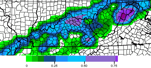
kyweathercenter.com/wp-content/uploads/2014/02/SPECIAL-2.png
However, I was more than happy to trade the snow for minimizing the ice and that’s how it turned out. Thus, I am quite pleased with this bust. In fact, I hope CB keeps busting in our favor all week when it comes to anything ice related.
Best comment so far…..
6 inches in western Franklin county.
Moving on……..after last night’s bust (and I don’t mean the Super Bowl), what’s on tap for tomorrow night?
Super Bowl, Super Dome, or Super Snow?
I am now jaded a little more due to disappointment so I will quote one of our most quoted presidents, George W. Bush:
“Burn me once, shame on you…burn me twice, shame on…shame on…ain’t gonna git burned again!”
Well, not sure why so many people are crying bust. Every met I listened to including Chris mentioned somewhere that the lines would be hard to predict. We got at least an inch or more of sleet in Raceland and it is STILL snowing on top of that and has been since the early morning hours! The lines moved a little north but at least we were all warned and prepared. I think that makes for a good met! 🙂
It’s because there was a fairly broad area that was advertised for 5-10″ Only places that even came close to verifying were scattered 7″ reports in and around the Louisville metro area.
Mason, WV has 8 to 9” and we were in the 5-10” range. Appears to have had some sharp cutoffs. Charleston, WV was getting rain and we are about 60 miles apart.
Come to Fleming, Mason, and Lewis Counties…..but be careful….We have 10 inches and some places in Lewis/Mason have over 11′. Nowhere close to Louisville…
I agree Snowlover. I like to know the “possibilities” so we can prepare. When you live on a farm and have animals of all sizes to care for, it’s best to anticipate what might occur and be ready than to be blindsided by a big storm system. The fact that Chris forecasts the possibilities way in advance is one reason I follow his blog posts. The other reason is that I enjoy meteorology and learn a lot from him. 🙂
The track for Tuesday storm seems to be ideal but yet appears too much warm air in play again. So frustating
7-8 inches in Mt. Washington
Another thought, not only did CB remain bullish on snowfall totals at the 11 newscast, but the HPC issued a product for very heavy snowfall rates in central and east Kentucky.
I was a bit surprised that snowfall totals weren’t reduced because 1. the back edge of the system was making decent progress into western KY and TN. 2. observer reports during the storm were mostly rain and sleet, even with 32 degree temps. I drove from Louisville to London yesterday evening. The drive home and road conditions pretty much matched up with snowfall totals. Shelby county to about somewhere between exit 62 on exit 75 on I-64 were treacherous. Once I was in Fayette County, the snow switched to sleet and rain. From Clays Ferry to the Rockcastle line it was just plain ole rain, at 32 degrees.
I measured 3″ of snow at my house in NW Lexington.
What do you folks think about ice chance tomorrow around Bowling Green? I am hearing RAIN, but Chris says ice… What do you folks think?
Rain for sure for southern and most of central KY. North central KY will get in on the fun, one again. That is, if you consider ice “fun.”
I live in the western part of Lawrence County, Ky. Can someone explain the geographical reason we stay in a warm air bubble during these rain /snow events? We have creeks running to the tops of their banks but only about an inch of snow. We were in the 5-10 inchessof snow forecasted area. 🙁
Lexington actually set a record snowfall for this date of 3.7 inches. “Busting” the old record of 3.6 from 2009 🙂
Progress
main roads clearing up in Lexington. Side roads are still bad-little traction- please slow down folks!
we ended up with 5″….not a bust for us….beautiful SNOW for sure!
plenty of angst from the Monday Morning quarterhacks…yikes!
You must be in northern Lexington, here in south, we have 2 inches. A bust here!
My 2 cents here….Someone posted earlier that forecasting in this state was as easy as forecasting anywhere else. B.S.! Kentucky ,Tennessee, Virginia, and North Carolina are among the hardest states in the nation to give an accurate forecast. There are so many more variables in play here that can effect the weather outcome accordingly as opposed to other states/areas. Haven said that, for most of you guys, this storm was indeed a bust, but I do believe Chris is doing a great job in general. Does he rely a bit too much on models….yes, and so does almost every other met. You win some, you loose some. Bring a met here from say Dallas, Detroit, or even Minneapolis and I will guarantee they would get your forecast wrong 90% of the time…..
Wow…you “guarantee” that last sentence? Don’t label this guy as a forecaster.
Keep on doing what you are doing Chris. There appears to be quite a few regular commenters on here that should consider adding another hobby to their repertoire. So much anger and frustration over a prediction…so sad. I do feel bad for some folks, maybe that is all they really have to do in the winter…its awfully quiet in the summer. Maybe these people actually enjoy life then. Winter weather systems in this area are predictions, using the tools you have at hand…It’s hilarious how bent out of shape the armchair “meteorologists” here get when you don’t nail down the exact conditions right where they are standing. Its weather folks, don’t let it ruin your day…breath, chill out and live a little.
the sleet really took a toll on our snow totals, but we still have between 4 and 5 inches out there, it is a layer of ice, then sleet then snow then sleet then snow, You get the pic, LOL Still very pretty! We have now missed 11 days of school this winter, 4 of those days are due to the water issues but our city school never misses school so this is a CRAZY winter for us. Wondering what these next systems will bring our way.
I just noticed there are two Lori’s here! I’m Lori B and live in Cincy. I’m relatively new to Chris’s site and use to blog a lot with the Local12 storm boards before they were discontinued. I came here hoping to be engaged with all things weather and learn a thing or two. While there are many here who do educate and post with respect, I see there are some who don’t. This can be a wealth of info for us and a place where we can learn and appreciate the weather. I appreciate all mets whether they are degreed or of the armchair variety and learn from both. So thank you to those who make this page engaging, including Chris.
What was the “OFFICIAL” total for Lexington? Looking outside my door in northwest Lex, it’s beautiful and completely covered. I’m not sure how much we received but this looks about the same as the last storm where the official was 4.1 believe.
4.0. 0.3 yesterday and 3.7 today. That was as of 7:00 A.M. A bit more might have fallen since then.
Here in south Lexington, we ended up with 2 inches, which is what I measured on my deck. I can definitely tell in my area that this is less than the last storm. Snowfall map here http://www.crh.noaa.gov/news/display_cmsstory.php?wfo=lmk&storyid=100129&source=0
We ended up with almost an inch in Knox
Of Rain
Well he did say 1″ to 3″.
question…will the snow cover help lower temps for tomorrow night/Wednesdays system? Or is that warm upper air that seemed to derail last nights event more in play? Lexington is consistently on that 30-35 degree temp variation lately, doesn’t take much shift to go from rain to ice it seems.
Just goes to show don’t take the Nam and GFS as the gospel..There pretty to look at when showing eye candy but seem’s like lately when it come’s to winter in Ky there wrong 90% of the time… I wonder what other short range modeling were showing yesterday…When looking at the Rap yesterday it was showing more sleet than anything for my area..I received no sleet but obviously a lot of other’s did..
Sighed..
Cold Rain
So guys, what are the runs saying for the next system. I heard the local guy say rain the rest of the week with no chance of snow or ice. Is that the new consensus?
8″ in Gallia County Ohio. On the Gallia/Jackson County line (Thurman).
Also i think CB done a wonderful job on his forecast yesterday..Just think about it..If forecasting is as easy as some of us think it is then obviously we wouldn’t need any met’s..A whole lot of stuff goes on in the upper Atmosphere than my tiny brain can comprehend..
Watch for once something shift South and put KY in the ice.
http://www.crh.noaa.gov/news/display_cmsstory.php?wfo=lmk&storyid=100127&source=0
Mostly rain with a little snow/sleet down here in good ole’ Pulaski County. We never get the snow, but I’m glad we didn’t get the ice like Chris was forecasting. I appreciate you, Chris, and your constant updates when things are looking ugly. I’m hoping before the winter is over, us snow starved people in Southern Kentucky will get some much wanted snow. If not, that’s fine, too. Bring on Spring! 🙂 Everyone have a blessed day, and be safe if you have to be out and about in the covered areas!
Folks sitting along the Ohio river I-64 corridor good luck tomorrow night looks to be a disruptive ice storm.
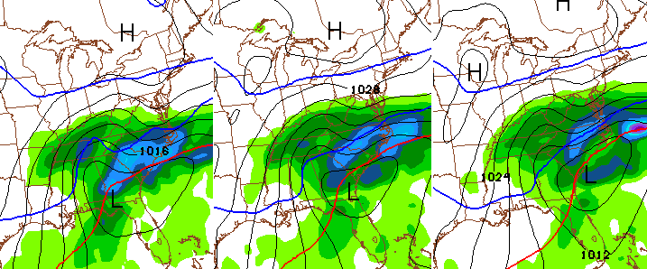
The latest run of the GFS is a potential disaster for Louisville. It paints almost the entire event on Tuesday and Wednesday as ice with snow just 20-30 miles north. The track of the low is through southeast Kentucky, normally a great track for snow in Louisville, but we all know this is Kentucky.
I expect the general pattern of frozen coverage to be generally similar to the snow from the current event. Simply put, the areas that got the snow, likely could also get the most ice for the next event.
Can anyone post the new GFS Chris Bailey mentions? Says Ice even worse that this mornings run. Which model does the best for thermal profiles at different layers of atmosphere/surface?
I don’t have a public link I can share because I use WxBell. Regardless, the track on the GFS and the Canadian are pretty similar. They take the low through southeast Kentucky and keep the freezing line well south of Louisville. The 0Z Euro is further north, but we haven’t seen the 12Z run from that model yet. It should be out around 2 or 3.
All rain with barely a dusting here in Somerset out of this one. Don’t mind that this one missed us as we were in the ice zone. Looks like we might be out of danger for the next one too, by the look of the current print out. I know, I know that can and will likely change. But as of now, we might get lucky again. Be careful out there you guys that got the hammer on this one. Have a great Monday! Thyanks again Chris for all you do for your followers. Now get some rest. Looks like you may need it from your blog post! 😉
Yes, being in a southern county for this Tues-Wed go around is definitely a very good thing. Unless things change, this should be purely rain for us.
When it was 29 degrees and it was still raining and sleeting I knew we were gonna miss out on the snow here. All we got was a skiff of snow. I’m hoping this weekends storm will come further south this time. Ha Ha, right!
Still world’s apart from model’s regarding next system…Nam has the low going through SE Ohio and the GFS going through southern Virginia..Other Model’s have the low more northwest..Would say the GFS is on an island right now..Not to be trusted..
The storm last night dumped about 5 inches of sleet and snow on the suburbs of Millville in Northern Woodford Co., which was in the forecasted range for our area. Great job at forecasting where the higher amounts of snow could fall, Chris! Don’t let the critics get you down!
Dont bite for any one model, just look at the patterN..which is LOADED!