Good Monday, everyone. The next winter storm is taking aim at the bluegrass state and will arrive on Tuesday. This looks to bring a messy mix of rain, freezing rain and snow our way. The blog is back in Winter Storm THREAT mode for this system. This is mainly for central, western and northern parts of the state.
That is where the latest models are hitting for the potential for decent amounts of freezing rain and some snow. The GFS continues to be the most aggressive…
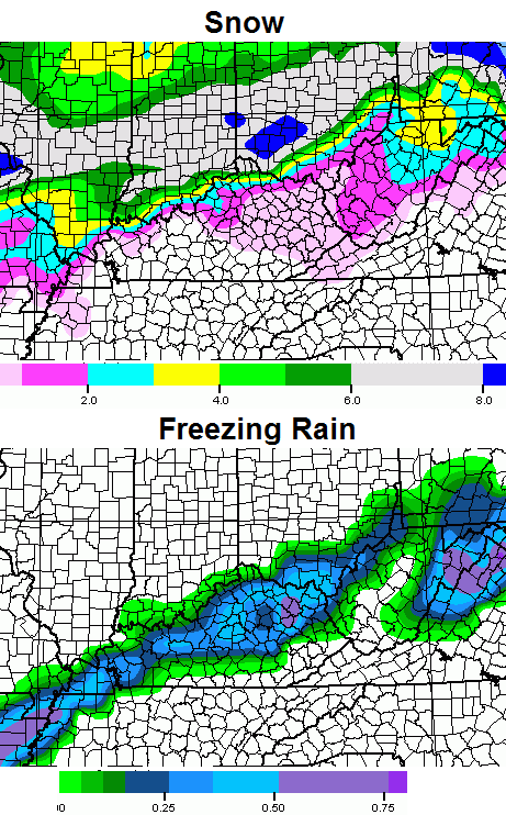
With as much as 3″-10″ of snow on the ground from this last storm… freezing rain on top of that could get ugly in a hurry. That is the biggest concern going forward and something I will be watching very closely.
A shot of very cold air comes in behind this with temps Wednesday falling through the 20s with snow showers and squalls around. Highs by Thursday may not get out of the teens as lows try to head toward single digits.
The storm coming this weekend could run from the Gulf of Mexico to the New England. This has the look of being the biggest and baddest of the winter.
I will update later this evening. After a short nap this morning… it’s back to work I go. Take care.

another non event for the SE outside of heavy rain and since ice is the main player could care less
Andy I am so surprised to read this from you.
I do hope you and all the other snow starved people get the big one. I am sure you want snow and it isn’t like this is not the season for it. I am sure eventually you get it and probably much more than you want. Seems to be the nature of it.
I should have clarified lol could care less about this 1 event this coming weekend is the money maker
Well, we can at least HOPE it is, Andy. I am tired of wading mud and looking at rain, too. Guess we are in this thing together.
No doubt about the mud. Every winter. Mud everywhere. And the river is at the banks so the creeks should stay up decently well for tomorrow. If it is heavy rain and freezing rain may just need a boat.
And Andy, I want the one this weekend to be good. Just wish we could skip the heavy rain and ice events. These big pine trees are sagging here so if it stays cold , currently 30, we could be in for a very rough go of it with this next one.
freezing and thawing of ground plus all the water also makes for hill slides
Andy, I hope the trend busts and you get a foot of snow for you and your kids to play in. I’m in Flatwoods, KY, way up N.E. KY and its been pretty decent here this year. Well over a foot has fallen here so far. Only about 4″ with this last one. Good Luck!!!
Many year reader but rarely post…..
Where is winter for Southeast Kentucky? Are we supposed to have just a rain year after year after year and very little if any snow. We are snow starved down here but we definitely in a no drought mode. I just hope one day before I’m dead I get to see an old fashioned snow. I agree with you Andy. I care less about this next storm coming through. All it is going to do is cause floodings and muddy conditions.
Me too Andy……guess we are not getting anymore snow cream this year!!! 🙁
I have a simple but yet probably effective idea for those in southern and eastern parts of KY who complain about their lack of snow. MOVE NORTH! Geez people, Chris can only report what he sees!!
LOL…Exactly. If the track moves south, great. If it doesn’t well spring is close 🙂
That’s funny, if you were here a couple of winters ago, folks in the Louisville area were moaning and groaning about the east getting snow. How times change LOL
I never could understand complaining about the weather. It just happens and not much anyone can do about it. And I am convinced even the weather has no idea what it will do next. It may bring a small storm that changes the dynamics and totally changes the next system.
So many variables that change so much. And especially in Kentucky. It also amazes me how we can go from almost 70 (forecast 56) to 0 so fast here. As well as rain to ice to snow. And maybe back and forth. Yeah, CB and his colleagues have such and easy job.
They’re STILL throwing a hissy about how they “never get any snow”, but I think it’s already up to about 20″ for the winter in the Ville w/ the snow last night. I am in Nelson Co. and we got around 4 hrs or so of sleet/Frz. Rn., plenty of icing awakening to about 3″ of snow on top. Tomorrows’ system will likely bring us here the usual Ice Storm (we can never escape them, it seems, here in Bardstown..we attract them like trailers do twisters…) while anyone 12-15+ miles to our North (Bullitt/Jeff. Co’s) will probably end up with more SNOW. That’s how it rolls here. :/
Geez..I will remember these word’s when the Eastern part’s get buried this weekend while flurries fly around for the rest..Rolo say’s “Old School” coming for the East and it knot gona be purty..
Oh. that;s a good idea Joey. I think I’ll pack the moving van this afternoon! hehehe 😉
On this one, I’m all for the Northward trend. Trend this run of the GFS about 75-100 miles North. You just know it is not going to trend South! 🙂
Ironically, areas that got snow from the current event appear to also have the chance to get more ice. Not just due to the current snow, but the same cold air patten over the state that helped for snow, might make ice more of an issue as well.
What time Tuesday is this expected to come in? Tuesday morning? Tuesday around lunch time? Or late in the day Tuesday? Just trying to figure out if it’s worth driving in to work or not.
Tuesday evening into Wednesday morning for the next event, so if you have a 9-5 job you should be just fine tomorrow.
Fencetucky is holding up strong in this run of the GFS. No snow south of river while north gets pounded, again! I mean, look how the snow follows the KY-IN/KY-IL border, EXACTLY!!!
No!!!! Not the ice word!!!! Here on Rush we got about 3 inches of sleet/ice and another 2-3 inches of snow of snow on top of it 🙁
dangit if you don’t make the forecast that I want for my area I’m gonna be grumpy and complain!
Well you could move North as Joey Suggest’s..
sarcasm…just poking fun 🙂
I believe I mentioned over a week ago that the Tue/Wed system would produce a ICE storm for areas along the parkways with heavy snow to the north. Add the North West shift and that puts most all of KY in heavy rain. Not going to be good on top of the current snow pack. Weekend event has a very good feel to it. Especially for the Ohio River Counties.
How would the Ohio river counties benefit from an apps runner/nor’easter? They usually don’t. These type of systems, depending how far west they track, affect eastern Kentucky.
Depends on the track of the low
Well folks, I’m from Hazard. You won’t hear me complaining that we got mostly rain last night. I don’t want my electricity to go off. It went off last winter for about a week, and I can tell you that it got cold in my house.
How much freezing rain does it take to start causing power issues?
We got what we got and life goes on. Glad that Char was spared. 🙂
Look for watches and warnings to start getting issued for the 1-64 corridor. Anywhere from a winter storm watch to ice storm warning to freezing rain advisory to winter weather advisory. Got be concerned for the folks on the I-64 corridor maybe a county or two south with decent snowpack clear sky’s tonight radiational cooling should take place low’s in the lower 20’s. With clouds on the increase overnight but not before the radiational cooling takes place and temps in the lower 20’s to start Tuesday temps will struggle in the I-64 corridor to bust the freezing mark at the surface. That’s spells big time troubles. If this scenario plays out with most people on the I-64 corridor sitting at 4-7 inches of snow and then throw in a significant ice event no doubt there will be big problems. Once that system leaves it might not get above freezing again till maybe Monday, and by then system number 3 will be here. That to has problems written all over it.
I shoveled every surface I could on my property today in anticipation of an ice event. Hoping to at least have a head start on getting out! Not much melting today here–though the sun is trying to come out. 1-2 inches of rain on top of this wouldn’t be pretty either.
Hello Tom.
Hello There.
Freezing rain on top of the 4-5 inches of snow we have now does not sound like fun. I’ll be glad to let a snow-starved weather critic shovel my driveway while I check on flights to Jamaica …
Everyone has to be a smarty pants on here, I think some thrive off it and live for it 🙂
I bet snow will not be an issue this time for any location in Kentucky. Winter storm watches hoisted for central and northern Indiana and Ohio. Those places look to get rocked by 6-9″ of snow. Hopefully the ice will remain north of the river. For the rest of us here in Kentucky, more rain.
Rain or ice would be bad here right now. The ground is frozen–plus rain over this snowpack would lead to some flooding issues I would think? But I will take rain over ice.
Yes..I see nothing for the entire state except Rain,Rain,Rain…Sry Northern Counties and Western counties and Louisville Metro…Now this weekend Lookout Eastern Ky…Everything is sitting exactly where we want it right now..This is the one we all have been waiting for..
Ready4Snow-
I can’t tell if you’re being sarcastic re: this weekend’s storm. If not, where are you seeing model runs/data for this system? What kind of impact will it have, if any, on eastern/southeastern KY?
Appears that the current snow envy might change to both relief and empathy to those same areas. In general, the snow today could have a big prICE to pay tomorrow.
I’m in Wayne County, and it looks like we are missing out on all the action! We had a little ice this morning, and tiny little touch of snow. According to this, we aren’t expected to be in on this event either.
I have tickets for the UK game tomorrow night. I would be coming from London & coming back after the game. Should I go?
Moving to Vermont where I’m sure to get snow 😉 Just joking. Weather here this winter has been good. Enough cold and snow to keep the bugs down this year and keep the ground in good shape for the farmers.
I agree !
Thanks Chris. Once again, we are on the freezing rain side of things. Hopefully we can luck out again and not get ice. (
tired of rain, too, but, would rather have that than ice. Guess we wioll see how it all plays out. Looking toward the weekend, please, Chris, if it is a big snow maker, please tell it to give some love to us folks in the southern parts of the state. 😉 have a great afternoon, everyone.
I was looking at accuweather to see what they were saying about the ice and one of their guys, Henry Margusity, has a map showing another 6 to 12 inches of snow for KY for Tuesday to Wednesday. I wonder why he thinks we’re going to get that much snow again?
Yeah, saw that and some other mets on another page I’m following are saying Henry is “out to lunch” with that map. I’d love to see it happen though. I am really excited about the next week of weather; best chances of some serious snow/ice I’ve seen in awhile.
I haven’t seen that map. But it’s Henry that doesn’t surprise me.
Henry has been out to lunch for years 🙂
I have tickets to the UK game tomorrow night. I would be coming from London. I would probably stay the night. Would I be ok?
Should I go or stay home?
When will the next maps come out? Thank you.
Just saw Henry’s map I think is map is backwards the map for tomorrow’s storm is on the Saturday- Sunday map. Saturday-Sunday map looks like it should be tomorrow’s storm. That’s my best guess. If his map is right for tomorrow which its not he would be the only met predicting that scenario for tomorrow’s storm. What he’s seeing is well beyond me.
The Euro Model at 5-6 days out showed a rain setup for most of KY and possible wintry mix along the Ohio River.
Still not sure if it will work out that way, but the NWS Louisville is throwing it out there.
This is a setup I’m glad to miss out on, ice no thanks
I sure hope Burgin misses the ice!!!
No snow in Adair county again!!!! Hate living under the snow dome:(
The 12Z Euro says pretty much the same thing the GFS says. The freezing line stays south of Louisville for the entire event. I know it’s not a forecast, just a tool, but that would indicate a serious ice storm for Louisville. Not good.
LMK not too impressed with the icing potential for most of Kentucky in the afternoon forecast discussion. Says perhaps 1/4 inch in the Indiana counties and maybe some potential in counties along the Ohio River. Looks they are thinking rain for most of Central Kentucky.
The supa’ powa’ of the warm air with winter precipitation in Fencetucky can not be denied. It is almost an entity. All hail the mighty Torch!
Its a showdown between the GFS and the NAM. GFS says ice storm for I-64 corridor. NAM says not so much but the NAM has trended the freezing rain ever so slightly south the last few runs. My gut tells me if temps drop into the lower 20’s tonight and then clouds build in with no sun tomorrow and the warm front not forecast to make it to the I-64 corridor one would think with the snow cover and clouds temps would struggle to hit the freezing mark especially where the snowpack resides.
NWS downplaying a system? never lol.
They also said 1-2″ just 24 hours before this last system. oops
Which was too high actually for most areas except the north. That means they were right for 2/3 of the state, so that seems pretty spot on if we consider average coverage. A lot of areas got nothing to an inch. Seems just as misleading though as cherry picking the results today and calling it a good forecast. Neither appears correct from that perspective 😉
Warm air is a force STILL not respected for winter precipitation in Kentucky overall.
I was talking about NWS calling for 1-2″ in the area that received 4-7″ Bubba 😉
I will never cherry pick, either. I don’t like them. haha
to be more specific…Louisville NWS, since that was the NWS Chris Mercer was referring to.
Test…
Love it when I post something and it vanishes. I bet this post will appear though!
You are correct, sir.
figures
The NWS in Wilmington going with a FLOOD WATCH for Lewis, Mason and Robertson Counties. I have a Winter Storm Watch for precip types and amounts that would warrant an advisory if no changes are made to the forecast. Interesting.
Where are you located Shawon? I’m in Cincy and are now under a winter storm watch and I’m wondering the same thing. Perhaps it is due to the 1-2 tenths of an inch of ice?
I will likely be in Cold Spring, Campbell County while the event is happening.
I believe 0.1 – 0.2″ of ice is not Winter Storm Warning criteria in our neck of the woods. That would be a Freezing Rain Advisory, however. A noteworthy event nonetheless.
It currently is 30 here. Some of these big pine trees have sagging branches from the weight of the snow sticking to them. Tomorrow may get very interesting. Not to mention the creeks and river being way up and at or near the banks. And then there is a system this weekend and then…. I really do like snow. I really do, but I also really dislike this mud. And I think I dislike this mud more.
Jackson NWS , in their AFD, is already discussing the possibility that Saturday’s low will trend northwest, leaving eastern and SE KY with, are you guys ready, RAIN!
Some latest models show the weekend low scooting through Georgia….And Jackson is still not certain on precip type tomorrow night…
Test
Got about 5 inches of snow here in greenup, with a sheet of Ice under it…it hadn’t let me post all day! Lol
Biggest snow of the season to come says Chris Bailey i sure hope it can beat 2 inches before all said and done 🙂
This weekend storm is looking very interesting
I hope it’s interesting for us folks around Lake Cumberland!
Storm this weekend starting to look like a northeastern US event. Hopefully that changes and we can get the bigger totals down here as well. Still plenty of time.
Storm this weekend starting to look like a northeastern US event. Hopefully that changes and we can get the bigger totals down here as well. Still plenty of time.
That is a relative term 😉 Some have had none are an ankle biter, so not hard to do. Counting our .75″ total today, we in Richmond are at 11″ for the total. Will we breach a foot?! Seems likely we will see a one incher to make it so! WooooHoooooo! Winning!!! Of course, most was gone in 24 hours, but is what it is 🙂
For perspective, this event was not supposed to get cut short on the map, but was by warm air and that was while the event was happening (the models were amiss). Considering this, how do we take a system that is nearly five days out?
Honest question and not a baited one. Warm air has not lost in years with this type of system flow. Betting against warm air for a lot of the state seems as harsh as betting against Tyson verses Urkel 🙂
Man we are so close to a biggin back here in the hill’s for this weekend…Keep the faith people..Were right where we wanna be at this time frame..Meanwhile first we have to get by the flooding rain’s Wed..lol..Sry Andy and Bryant..
Hoping for a snow to remember this weekend but I am cautiously, somewhat optimistic. Deep down, I believe it won’t materialize, but hopeful just the same.
You obviously must be somewhere north of the Kentucky river to be optimistic 🙂
lol. No, Middlesboro. If that low tracks across northern Georgia, we could be in for a BIG snow here, however, I do believe it will take a different track…much further north. trends, trends, trends…
The 18Z GFS seems to be showing a bit more snow for Central and Eastern KY than the 06z and 12z did for the weekend storm. Of course it’s the dreaded rain to snow event so take it for what it’s worth.
Keeping fingers crossed!
The north can keep their Winter weather, Im done with it all, Im looking ahead to warm sunny weather highs in the mid and upper 70s and storms.
Well, Whas-11 has high of 37 tomorrow, Wave-3 all the way up to 38, and Wlky-32 (which hit last night’s storm better than anyone else in Louisville) only up to 34.
All 3 stations have Louisville in the clear from the heavy icing. All saying a brief start of sleet, snow, freezing rain mix, changing to all rain.
So, as of now, Chris Bailey is the only one concerned with areas south and east of the Ohio river. Another interesting night ahead of us tomorrow.
This is of course for tomorrow (the highs and precip type)
Lol Wlky was calling for 8-12″ in nelson county up until 7pm last night. 1″ in southern NC and 2-3″ in Bardstown. Would hardly call that “hitting it”.
You are right….they didn’t hit the southern counties. NOBODY did. But, WLKY did hit the 4-8″ area they had highlighted, perfectly. Others, had that area at 2-4″ and 2-5″. I should have been more specific.
Definitely disappointed with our snowfall in Burgin overnight, but it was enough for a snowball fight. Wondering if we might get something out of this one.
The latest WPC has the low moving further south AND east. Pretty much taking it right over fast south and east Kentucky.
If this truly is the track, then Chris Bailey looks like a genius right now with his new weather map he released on air this evening.
fast=far
Still looks like that track would hug Ohio River counties with most ice?
http://www.hpc.ncep.noaa.gov/wwd/day1_pice_gt_25.gif
http://www.hpc.ncep.noaa.gov/wwd/day2_pice_gt_25.gif
Those track clusters on the low are also interesting. Say that thing swings through West-Central Georgia and then rides up the apps into West Virginia–something they are showing as a possibility. What happens then?
Sorry–meant West-Central Alabama
Hello everyone! A quick question for you, please, in anticipation of the next event to come our way. I just focus my attention here for my information but I see that several of you make mention of following Twitter comments, too. Who are some of the people or sites that you follow? I of course follow Chris, but are there others? I also saw someone mention seeing MJ on Twitter. Does anyone know what his name is there? I really appreciate all of your help with my questions! Thanks so much! Stay warm and safe, everyone!
Your local mets should have twitter as well. What part if the state are you in & I might can tell you some. MJ is @MJ33Wx
Carla, thank you so very much for the information! I am in Lexington, but only recently started Twitter, so I have some catching up to do! 🙂 I really would appreciate any suggestions that you have! Thanks so much!
MJ is Mark Jarvis from the NWS Louisville. He posts on here from time to time and always gives good analysis. I don’t “tweet” 🙂 but that is who that is.
Chris, thank you so very much about the information regarding MJ! I really appreciate your help! You and Carla both came to my rescue and I do appreciate your taking the time to help me out more than you know. That’s one of the big reasons why this is the best weather “family” – the way folks help out! I really appreciate it!
There is moisture of some sort, not sure if it is freezing drizzle or fog!!! Nothing showing on radar, in Whitley County! Anyone else getting this?
Once next week is over I’m ready to move on to spring. Average highs in my part of the state hit 50 on February 15 and with a little sunshine that’s warm enough to start enjoying the outdoors. With less than three inches snow for the year, this cold and snow less winter is getting old. Every promising system this year has ended up as a cold rain. I will give it a couple of more weeks 🙂 and then I’m searching the blog looking for warm, dry days.
6 inches in frankfort last night, pretty good winter in these parts so far!
can we call this winter storm from Saturday to Saturday winter storm missy after my girlfriend