Good Monday evening, all. I’m short on time, so I will get straight into it all. We have another messy winter storm that moves into the region on Tuesday. This will likely bring a nasty mix of precipitation our way. Freezing rain, sleet, snow and heavy rain will all be likely.
What you get depends on where you live and I’m still trying to figure all that out. The GFS continues to show the nasty mix farther south and east than it’s American counterpart, the Nam. Here’s what the GFS is cooking…
 As you can see, that’s a pretty significant winter storm look from the GFS with ice and even snow. The European Model actually gives the GFS some confidence with a similar temperature profile.
Southeastern Kentucky… watch for heavy rain that could cause some local high water concerns.
Looking down the road toward the weekend…
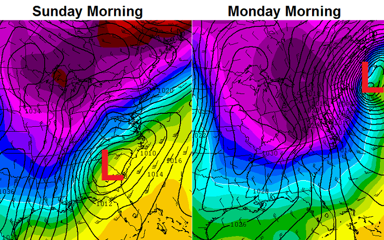
Every model has a similar look to what you see above. A storm moving from the Gulf and then up the east coast. That. Is. Interesting!
Take care.

drizzling precipitation of some type in London. May get slick.
Northern Knox too.
just got home…London is getting glazed over…icicles on everything, roads are wet. be careful!
Clay County too. It is very light.
Wow just found your site about a week ago(where have I been?!?!)
Anyways your expert analysis has been right on these past few storms,
Keep up the good work. Looks like you will be busy for awhile!
We dont expect anything but flooding rains anymore
I have a friend who works at Ober Gatlinburg, maybe she can sneak a snowmaker out for the weekend. Throw some snow in my yard and then I’ll bring it your way. 🙂
Sweet
This for both.
I’m sorry Andy. Just getting more rediculous down your way. Not sure what it is going to take to break the trend. Eventually your number will come up buddy. I’m rooting for you my friend.
The weekend looks interesting. At the very least, it gives us something to track!
I read your weather everyday and enjoy it. I live in east tn. and we all really need a good snowstorm before winters end. What do u think about this weekends storm? And oh by the way this is my first comment ever on your site
The razor-sharp snow line along the Ohio river is interesting. I’m curious: is that due to topography or the presence of the river itself?
Neither…..Has to do with upper atomoshphere and how far the cold air penetrates the layers among it. Colder air always to the north with the southern gulf air over running it. Melts the snow as it falls if the colder layer below Is cold enough the now rain drop will turn in to sleet if the layer is warmer and the surface temp is freezing or below you get freezing rain. If the column is cold all the way down you get snow.
I think you are on to something Jimmie. I’ve always noticed the same thing. I lived in Henderson for a few years and I’ve lived in Bowling Green and Glasgow for many years and a few points around Western and SouthCentral Kentucky. I think the Ohio, Mississippi, and Green Rivers do effect the weather and I think the topography plays a role, too!
I’m going with a different angle. I say that the river and topography are caused by the weather, not the other way around. I’m thinking that, over the long term, weather patterns have traditionally gone the same ways with the northern side seeing more snow and such and the southern side being warmer, and that the river is a result of that — well that and it also marked the edge of the glaciers during the last ice age.
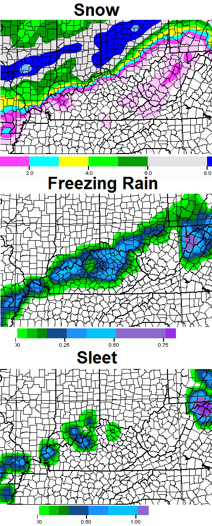
I’m illiterate to what some of the colors mean on weather maps. Could someone please explain the above maps to me?
On the upper maps you just have to read the legends below each map. Amount of precip. On the lower map the deep purple and blues represents colder air. The lighter the color the warmer. Then freezing line is generally along the dark and light blue. Green, yellow and orange are all above freezing.
Also on the lower map, the black lines are isobars (lines of equal pressure, in millibars). Note how close the isobars are around that low, an indication of how wound up this storm could become!
Which is why I believe it will pull northwest of the current track.
Bryant you out there? Weekend system is showing East of the apps. Means southern and eastern parts of the state should see a decent snow as this heads up the east coast. Western, central and southern IN. Will be in cold weather with little precip. I like the placement this far out. Remember the NorthWest shift will happen. If this can go up the west side of then apps then all of Ky will have a decent snow storm. Oh except eastern Ky, could end up rain,
Soooo, we definitely don’t want it going up the west side….
He has no clue like everybody else what’s in store for late weekend..I’ll take my chance’s the way thing’s things are at the moment..Old man winter is saving the best for last and Eastern Ky will get pummeled…We don’t want the ankle biter’s..Old School baby,Old School..
C’mon Jenks, was that necessary? Rubbing more salt in the wound, huh?
Actually the saturday low has many different outcomes at this point. It could along the east of the apps which could mean a significant snow for eastern KY. it could track west which would mean a wider swath of snow, but also the possibility of a heavy rain to wet snow event. Or, it could never phase, head out to sea etc. But as for the current storm to be, not seeing where this will be a major snow maker, unless one lives in central Indiana. And I still would bet that the ice remains north of the river, which is a good thing, i would think.
Good thing except flooding rains on top of the 4 inches of snow we got last night. Not wanting ice though.
I see where Winter storm warnings are posted for central Indiana and Ohio. Those places will get hammered with snow. Really not seeing why CB is bullish on winter weather affecting our corner of the world.
What happened to the one on Friday? Just curious.
Im starting to lose count here. I don’t recall hearing about a storm for Friday. Then again last Thursday I didnt recall hearing about a significant snow till Saturday which happen yesterday.
I thought I read earlier that there was one coming in Friday evening…of course I could have read it wrong 🙂
Two big systems. Two big questions. Thanks Chris!
Sadly a lot of us have already gotten a lot of answers we do not like and same as previous years. The positive though is perhaps the areas not impacted by snow will also miss the main ice if it hits. You know things are rough if CB is having a hard time with ice- those systems are usually slam dunks.
My grill outside is covered in ice ????
I have a dumb question, so I apologize in advance. On the latest model run above, if my county is completely covered in light green under freezing rain, does that mean little accumulation of freezing rain or none?
Close to none.
Thanks Chris.
One tenth of an inch. Nothing major for you in terms of icing, but watch where you walk as it will still be very very slippery. Now if you are under the dark blue or purple that is a different story.
Well, some areas will briefly go from winter to spring just like that, but that’s fairly normal for us 😉 . According to the SPC, Tuesday may have a thunderstorm or two as far north as western and south-central Kentucky. But what little chance there will be of severe t-storms will hopefully be confined to Mississippi and other parts of the Deep South.
Hard to believe that it will soon be exactly six years since the 2008 Super Tuesday outbreak of tornadoes. Both KY and TN were hard hit.
http://en.wikipedia.org/wiki/2008_Super_Tuesday_tornado_outbreak
Still seems like the areas that got snow have the most chance for ice- if it pans out (hope not). Due in part to the snow on the ground, but more to do with the patter for cold air that has played out steadily this winter. it helped for the snow and could also provide the air foundation for ice. Likely a little too warm to impact the areas that did not get the snow.
Will be interesting to see if it plays out this way. If close, rinse and repeat for the weekend system. Southern fed systems have a batting average of 0% for the areas that were missed today- over half the state.
And the new NAM comes in colder for tomorrow’s system I-64 corridor looks to have problems
also rather interesting that CB says he thinks the Watches should be further east and south of the Ohio. Then Mark W from Fox-41 (who has been saying for nearly a week, don’t believe the hype, this a rainmaker only for everyone) comes on and says “I think the watches are beautifully placed by the NWS.” haha….you think that was meant for anyone?
Last night up here in NKY one of the Cincinnati weather guys said this week’s system would be all rain. Now less than 24 hours later they are on board with snow, ice, and freezing rain. Maybe a little too much emotion in the forecasts.
Mark Whineberg…hmmm…I used to like him & his forecasts, but lately….??! :/ My aunt in OK has icing & snow right now near Tulsa (just spoke w/her) and THEIR wx-ppl are saying it’s hitting right through KY…which is what their last system did last night….except it missed Bardstown…lol! 😉
I am a winter lover, whether it be cold, snow, ice, etc….I am prepared for the ice, which I think might slide a little farther south than what is the current thinking…..we’ll see?! 😉
I have an Aunt in Tulsa too! LOL
Of course they do…now let’s all hear the whiney-butt’s from those in Jeff. Co and along the river & on North….. “We NEEEVVVER get any SNOW (ice, whateva…)!!!”…..You’re already about 18” ahead of me in snowfall in Nelson Co. this year….and last year. Just once, I’d like to see us down here get something besides a “paw-biter” (as my Border Terrier says….) I know you’re talking about ice, but hey…we’re “Ice Storm Central” down here! It can’t snow, but we sure know how to do without cable for 9 days and fall and break a clavicle bone! 🙂
Tell em’ Deb! 🙂
This might be opposite and the areas that got snow might end up paying the prICE for it tomorrow. If it does happen, let us hope the ice is not too much. Plain rain for the win!
Once again I’ll ask who is whining in Louisville? Sorry you didn’t get any snow but the comments are getting old.
We keep getting footers running along the bottom of our local tv station, from the NWS, about areal flooding, but it doesn’t give the timeline. Is that Tuesday’s storm?
I’ve seen a couple different forecasts for tomorrow night…we have about 5 inches on the ground here in northeastern ky..about 25 miles north of i64
c-BIV, you hit the nail on the head regarding mw and cb! Funny how mc thought the watches/warnings were perfectly placed……except for those two KENTUCKY counties!
Debbie, settle down
c-BIV, you hit the nail on the head regarding mw and cb! Funny how mw thought the watches/warnings were perfectly placed……except for those two KENTUCKY counties!
Debbie, settle down
You let Deb fire away! 😉
I don’t know where you live, Bubba, but we’re on straddling the fence HERE, too….kinda hurts when you get snagged in the crotch every time, huh?? :/
North Richmond. The true belly of the beast known as the place where snow doth not dwell. Well, not much and if over a few inches, it lasts about 24 hours. Kind of like a quick flu bug.
Don’t back me in a corner when it comes to winter wx…lol! My collarbone still hurts from ’09, (that was due to the dogs, not the ice…the ice had melted, but the backyard mud & 8 muddy paws on the kitchen floor = mama slams into the fridge real hard!), but I am all for anything we can get here in Bardstown. Sux to live here….they call for a big snow, well, you have to drive on a skating rink to see THAT, some 12+ miles to the north…..if it ices, it ices..if it snows, it snows…if everyone all around me gets snow and I get nada, then bring out the Xanax!!!! lol 😉
Fire away, Sweet Momma! I see no corners for you.
All you weather watchers help me out. Most maps mean little to me because I don’t understand many of them. But these upcoming storms, does it look like anything for south central ky like adair county???
Think it’s safe to say you will stay all rain
I’ve wondered about the Ohio river theory…………but, that theory gets smashed since Covington and northern KY get good snows.
It is the Kentucky River SynDrOME and it ain’t a theory. It is scientific fact. Bigfoot, ghosts and UFOs need to take a back seat to some real science!
All hail the mighty Torch!
My subconscious mind read DOME and alerted me immediately! False statement, it’s the dome, it insulates the heat from the Blowtorch, right across the fence.
It is on the freezing mark here and there doesn’t seem to be any rain but there is a mist feel to the air.I went on the porch and the rails and the steps have a very thin layer of ice and its slick.Hopefully its not enough to make the roads that way.
20 here in greenup
I live near huntington wv and still follow CBs blog. Im glad that sometimes his weather report extends to cover our area some. Miss having him here, no one else compares. God bless you and all of your hard work you do for us
17 in frankfort, getting colder than predicted??
Interesting update made about 10 minutes ago by the Louisville NWS, and at the very least, it has a more concerned tone than was present in the afternoon discussion. Worth a read for those under a snowpack. (Note: I’ve edited out a paragraph related to fog to reduce length, full discussion @ http://www.crh.noaa.gov/lmk/)
…Forecast Update…
Issued at 1156 AM EST Tue Feb 4 2014
…Concerns about Existing Snowpack and Temperatures Tomorrow…
Of bigger concern regarding current temperatures over the snowpack
is how it plays into the onset of our winter event later Tuesday.
With upper level clouds already streaming overhead and a notoriously
cold steady northeast wind expected for tomorrow. Having trouble
seeing how we will get to the current forecast highs (mid 30s)
across the snowpack. Furthermore, certain higher res models that
performed very well with Monday`s high temperature are painting
highs only in the upper 20s across the snowpack for Tuesday. This
would make sense meteorologically based on all the factors mentioned
above. With the QPF values forecast for tomorrow, am very concerned
about what upper 20 surface temps would mean to ice accumulation
compared to 30-32. Complicating the problem even more is how hard it
might rain at times and the negative impact that could have on ice
accretion. Will be working the forecast over the next few hours, and
expect a decision to be made on the current Winter Storm Watch in
the pre-dawn hours.
Oh dear sweet Jesus! Could the snow pack we have NOW complicate temps tomorrow? I wondered this………..But I also thought the same thing when we had the saturday morning blizzard, only the end up really warm the next day……….The snow pack THEN didn’t have any problems keeping the atmosphere colder, so why would it now? I guess there are a lot of variables I just don’t understand…….:(…….. I mean, NO NO! Not temps in the upper 20s with heavy rain!! That would be crazy