Good Tuesday, everybody. Here we go again. Another winter storm is taking aim at the region and will bring a little bit of everything to the bluegrass state. As always, location is the key to what kind of precipitation type you see. Is anyone else shocked by that statement? I didn’t think so.
Here we go…
– Precipitation moves in from southwest to northeast today as low pressure approaches the region. The timing on this appears to be late morning and early afternoon in the west then late day into the early evening across much of central and eastern Kentucky.
– The snow pack is going to play a roll in what kind of precipitation falls today. Areas with the deepest snow will see colder temps. That means a greater threat for a wintry mix developing.
– Areas without snow will be dealing with mostly rain from start to finish. Heavy rainfall of more than one inch will be possible. That could lead to some local high water issues.
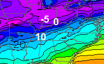
Here’s the first look at how things may play out later today into tonight:

Just the slightest deviation in temperatures could mean the difference between rain, ice and snow. Again… the greatest winter threat is across the northern parts of the state and those areas closest to the Ohio River. This is a textbook nowcasting storm for the areas with the chance for wintry weather.
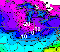
Colder air takes over tonight with a switch to snow showers and flurries for Wednesday. Check out the shot of cold coming behind that…
That’s the GFS forecast low by Friday morning. You can clearly see the influence of the snow pack at work. Speaking of… the models are trying to develop another storm this weekend. We will wait to tackle that one in the coming days. The GFS says it IF that storm is real and puts snow down around here… temps tank behind it…
That’s just for entertainment purposes at the moment.
Let’s take em one at a time and get back to tracking today’s storm…

I-75 @ Winchester Road Lexington

I-75 @ Iron Works Pike Lexington

I-75 @ Clays Ferry Bridge South Between Lexington and Richmond

US 60 @ US 127 Frankfort

US 127 @ Frankfort Frankfort

I-75 at MP 36 London

I-71/I-75 at Buttermilk Pike Near Covington

I-64 @ 3rd St. Exit Louisville

Downtown Louisville @ 2nd & Broadway Louisville

I-65 @ 234 Near Bowling Green

I will update things later today. Take care.

Live in Louisville. Will be an interesting evening. Thanks Chris.
Playing a “roll” is awesome.
I reall can’t understand your need to point out a rare error made by Chris. Congrats. You really have shown you know your third grade language arts.
So is playing a troll, right?
I am pretty sure he meant role. Just chalk it up to the stress of forecasting weather here.
Wow –
Boy did they drop the forecast high temp in Lex tomorrow by a mile………Was 36, then 35, now 26……
Funny how this is now 2 times this week that a storm turns wintery at the very last minute.
The NWS is forecasting temps 7-9 degrees lower than any of the local tv mets in Louisville for today. Every met I watched said between 34-37 degrees today. Someone will bust on their forecast that is for sure.
thanks Chris.
wow- what a mess. stay safe all!
Wilmington NWS in their discussion page suggests the possibility of an upgrade to Ice Storm Warning for all and/or part of forecast area, which is Cincy Metro including NKY. Looks like at this point, we are going to get a wicked bout of mother natures fury. Keep it safe everyone.
So much for the all rain theory, alot of METS playing catchup, Chris is the best, saw this coming way before others would play along 🙂
All rain will be a fact here
Surprised though this did not follow the same coverage area as the snow event. Expected it to be more south, so some in Lexington area too. Good for them! 🙂
BTW, never doubt the power of the Torch!
I for one am very thankful for an all rain event; the north can have all the ice they want …. i’ll take the rains today 🙂
Thanks CB for keeping us all informed. I really never second guess what you have to say, but I really believe the those line need to be shifted about 20 – 30 miles to the North. Especially for Jefferson county. We will see temps rise above freezing and get cold rain for this system despite the snow pack. Louisville is always warmer than the rest of the river counties. Will now cast to see if I need to throw salt later this morning. Have a great day everyone a be safe.
Wow, NWS forecast went from rain/frz rain to heavy snow for me near Henderson!! Rare to see that trend but loving it!
Rain and pockets of sleet look to be primary precipitation types from 5pm through 10pm for Louisville, according to the latest run of the Rapid Refresh model (09z/04). Surface temperatures will be critical, as they will be near the 32 degree mark. Although most main roads should be fine during that time as long as precipitation is light, accumulation of ice on everything else will be ongoing, at least 0.1″ through 10pm.
Thanks Chris. You guys in the ice/snow area stay safe. We here in the tropical region will get the ark ready. ;). I have ordered palm trees and sand for my back yard.
Hope you all can get a least one more nice wintry event down in southern KY before the season is over with Coffeelady.
Us Central and Northern KY folks will be glad to send this stuff in another direction. Today marks the 11th school day cancelled for the district I teach in (Franklin). My summer is quickly disappearing and replaced with make-up days
Sounds like CB is not sold on this weekend. Figures the one storm that might develop and take a favorable track for southeast Kentucky goes immediately on life support.
Oh well, you guys up north have fun with the ice. I’ll take my global warming rains any day and anytime over a crippling ice storm.
interesting thing a guy at accuweather Alex Sosnowski was saying about mid Feb ….. showed KY/TN starting Feb 20th warming up and said early spring and talked about temps in 50/60s the rest of the month and into March. Don’t know how accurate he is, but was interesting hearing him talk about KY.
Yeah, if this storm over the weekend fails to develop (which will probably be the case), I’m officially in spring mode. Its’ been a frustrating year, and I can’t imagine how frustrating it would be for a snow lover in far southeast Kentucky. At least we’ve had a couple of ankle biters here in London.
We here in Middlesboro have had a little more snow than you in London, but I’m right there with you Bryant….no show for snow this weekend = full blown spring mode for me as well.
Things look a little scary now, highs in the upper 20’s forecasted with thunderstorms in Lex! Now the RAP model (Rapid Refresh Model) is jumping on board the ice train with more than 1″ of ice! Nam still the outlier though. The only thing that could save all of us is if the WAA (warm air advection) is stronger than anticipated, in rhis case, we want the waa to overachieve unlike the last time when we didn’t wanr that and all snow melted.
*this
*want
The rrm was also showing 1-3 inches an hour during the last storm. That never materialized so the 1″ ice is more than likely not going to happen. The NAM is going to win out on this one and all of Ky will see rain with little icing along the Ohio River. Heavy icing will occur north of the river with heavy snow through central IN. The weekend system will be the ones to watch for KY.
Lets hope though, some strange things have happened in meteorology before (that defy the trend.) And always be prepared for worst-case scenario.
I agree! I would much rather have an ice storm warning go to all rain than the other way around. Have to prepare for the worst.
Bjenks if your on the I-64 corridor im thinking the ice will materialize. Here’s the thought process I-64 corridor is way below freezing no real sun today to help warm-up temps might make it to 34 degrees before the onset of the precipitation falls which cools the atmosphere another 3-5 degrees which puts the I-64 corridor around 30 degrees. Secondly winds at the surface are coming in from the NE which should keep temps right at or below freezing. Roads I think will be ok because temps will not fall to much below freezing but the trees and power lines are the main concern. Now the only way I can see the I-64 staying all rain is to get decent sun breaks to help warm surface temps. If that happens then yes primarily a cold rain.
Warm air convection will not be a issue at the surface because winds are coming from the NE. In the upper levels over the atmosphere warm air convection will happen but shouldn’t come down to the surface if your along the I-64 corridor. Warm air convection in the upper atmosphere is playing a big time roll thus the likelihood of freezing rain
It really seems like the NWS is more bullish on the ice threat for the Frankfort, Georgetown and Lexington areas than the local mets. Micah Harris basically showed the highest freezing rain threat across southern Indiana, and far northern KY this morning.
The NWS is saying those areas get more snow/sleet while freezing rain is more toward I-64 between the Lex and Lou metro areas. This seems to be more in the line of thinking with Chris’s map. I have a feeling that Chris will line his thinking more with the NWS as the day progresses.
Weekend system is trending more east and less of a threat for KY 🙁
EXACTLY what we want this far out
Oh really…5-6 days out and a trend is developing..
Winter Storm Warning for I-64 and areas north. Seems a little drastic to me.
It’s for significant ice accumulation
I just figured it would be more of a Winter Wx Advisory event rather than Winter Storm Warning. Especially for the Lexington area where it seems temps might be a little high for significant icing. Guess this will be an ultimate “nowcast” event because we won’t know until it gets here.
Is that pink patch on the radar hitting the ground? Anyone here live in that area?
There’s nothing hitting the ground in Danville. Just a little fog!
Spring is just around the corner and I can’t wait 🙂 Have a great day boy and girls!
Hey Barb, just curious as to why you follow this blog if you dislike snow. Most of us on here are snow fans. No problem that you’re not but just curious why you still follow/post here 🙂
Look, it’s not “Kentucky Winter Weather Center”; this blog is year-round. I bet some on here don’t even know Mr. Bailey posts on every one of the 365 days of the year. In fact, I can’t honestly remember the last time he missed a day. Can’t we show some love to the folks on here who don’t like winter?
I’ve shoveled twice now this winter. Had my fill. I am with Barb. Bring on Spring.
well said Jamie..lol btw.. just because I don’t like snow doesn’t mean Im not interested in weather..haha
i’m with Barb ….. not a snow lover but feel I have about as much right to post as you do. Chris lets it be known he loves snow but he never casts stones at the ones who don’t .. like some on here
Well since Joy told’s us snow lover’s to move North i guess he will be telling non-snow lover’s to move South…
I’m more of a warm wx fan.
But I still like the dynamics on how snowstorms form. I’m even fine with an occasional short-live snow cover (especially around Christmas if possible like in 2010), but then I want the sun and warmth back 😉 .
hmmm, last time I checked , CB reports on all types of Weather not just snow! KY weather center is the blog name. Weather doesn’t just consist of SNOW.
I have to admit I am ready too Barb. I sure hope it warms up March this year and does not remain cold until May again. Have a good day. 🙂
Have a nice day Ben
WAVE 3 here in Louisville is saying a quarter of an inch of ice and less than 1 inch of snow for us here in the Metro.
I think they are just going with nws.
Help! I can’t tell from all the different sources exactly WHAT is coming at us here in the Capitol City. I got an alarming winter storm warning alert this morning saying we will have significant icing??? Chris, what are your thoughts on this warning? Looks like our temps will only support rain so if icing is a definite probability, I need to prepare for long term power outage out here in the country…
Temps per NWS forecasted to be around 30. This is a NE wind. Won’t turn South till late tonight, and it won’t do much when that happens. But root for the heat!!! Blow torch us!
Hope you folks in the potential icing areas stay safe a don’t loose your power…and hopefully we here in southern KY won’t need a boat to get to work.
Hey Chris! Followed you all the time when you were in Huntington. I have a question. I live in Olive Hill, Ky. We currently have a sandwich of snow plus ice with snow on top of about 3 inches. It didn’t get to freezing yesterday. We get grouped in with the NWS out of Charleston, WV. No one here is calling for any ice. What are your thoughts for us in this lost area?? Thanks
Looks like my area will just miss out on this one. Thank goodness. This storm is going to be really bad for some folks.
I sure hope Burgin gets nothing out of this one….
I am sticking with my belief this system should have ice coverage that is similar for the areas that got the snow. My convention of thought was correct for the snow (though I hoped CB was correct) and will stick with it for the ice. Areas that got good snow coverage might want to watch out.
I received about 2 inches here in Burgin. So your thoughts are we will receive some ice?
Agreed
So you are saying the 5″ of snow we have in Louisville is a bad thing tonight?
Yes because the snow keeps temps in check. Which ultimately its much harder for temps to respond especially with limited or no sunshine. Temps are going to be real crucial for the I-64 corridor if the I-64 corridor can warm to 38 degrees the I-64 corridor should be fine but if temps only get to 35 degrees before precip hit then the chances for ice goes way just because there will be cooling that develops and that will drop temps below freezing.
Goes way up, sorry about that
Yea, it was my attempt at sarcasm.
Wave 3 has us at 30° for 10am. It is currently 25°… probably not a good sign so far.
In Louisville I only see us getting up to 32 or 33. 38 is way overdoing it. We have 6 inches in Mt Washington and the clouds are going to keep the temperatures in check.
With the way it looks and feels outside here in Frankfort I don’t think we will even get to 32 today. It’s 23 at 10am and a lot of snow on the ground. Still very foggy.
If we stay below freezing does that bode better for a snow event?
Everyone wanting rain north of 64 might want to think again, 25 in frankfort and not rising very fast, clouds and 5 inch snow cover will make above freezing a challenge today in this area!
Well hopefully the warm air will win like it always has in the past……….but it’s overcast and a good layer of snow here………
What I don’t understand is the ice accumulation forecast……..If the precip is supposed to be heavy and around an inch, who could that equate to .25 of ice with temps at freezing or below?
Mark that’s just it the precip will be coming down so hard that unlike snow it will be hard for the freezing rain to accumulate alot of it will be run-off which is a good thing.
how…..not who
It’s starting. Freezing rain now being reported in both Memphis and Jackson TN.
It’s freezing rain as far south as northern Alabama! NWS in Louisville has a good read why temps won’t respond like they have lately, different setup is making ICE much more likely northern half of KY!
Holding just above freezing here in Nashville. Should stay mainly rain, thankfully. But still not looking foward to catching my flight later today.
Not good in Little Rock; they’re reporting thunder and freezing rain. Much of Arkansas is under an Ice Storm Warning 🙁 .
If Danville gets nothing but soaking rain, then at least the salt gets washed away. #winning 🙂
Here is a link to the SPIA Ice Storm Damage Scale.
http://www.spia-index.com/SPIAIndexDescription.png
Sounds like the NWS now backing off a little around Lex and Frankfort area saying it should warm up just enough for plain rain this evening, we shall see, likely a good thing if it does?
At 28 degrees already..I think Lex will break 32.
You very well could but once precip starts you will fall below freezing
Someone ask this the the other day but I never saw an answer. What happened to the me Mesonet temps?
Brand new Mesoscale Discussion by the Storm Prediction Center about the ice:
http://www.spc.noaa.gov/products/md/md0064.html
And as CB just Tweeted, there is now an Ice Storm Warning out for northern KY.
Temps here are not climbing. We are at 29 currently. Guessing warm air will surge in or at least I hope it warms enough. We are south of 64. Had 2 inches of snow Monday morning early and we still have about 1 to 1.5 inches left. Should help add to the flooding as it melts.
I think we will see all p types in Louisville.
IMO Speed Skating is the best winter Olympic sport to watch on TV.
Yo
28
Here in greenup with a 5 inch snow pack…so this could be a bad thing? My dad said it’s awfully cold out
If so, I think charleston wv is leaving us poor northeastern counties out of warning area
I agree!!!
From what I’ve seen so far we’ll get some mixed precip but not supposed to be that bad. It could all change though.
In the 40s here in knott co
Looks like a nose of warm air with rain in Tennessee will save east central KY from a major Ice event, temp. Now 30 in Frankfort!
Currently 49 degrees and sunny here. NWS has already missed today’s high by 6 degrees. Maybe warmer temps will translate to some of you to our north not getting as much ice as forecast…
Love seeing all the of the opinions today, but it’s confusing me quite a bit. Some are saying rain only for Lex area, others are saying lots of ice. I need an update from CB!
I agree! I am a newbie to this blog and I can’t decipher all of the data people are citing!
In Nicholasville truck temp gauge says 28. Felt like a very cold wind bliwing just a few min ago. Either snow or rain. Dont care just not ice. Live in North East Garrard.
I sure wish Southern counties could get in on the action!!
Just a friendly suggestion…When you tell the temp and conditions where u live….TELL US WHERE YOU ARE LOL 🙂
We’re holding steady at 27 in western Hardin county with 4 or so inches on the ground. Forecast high was 38 this morning now lowered to 36. We were supposed to hit 30 by 11 am and 32 by 1 pm. I read the SPC mesoscale discussion and most of it went right over my head! Is the warmer air coming in with the rain from the south? Is the cold air already in place or is there also colder air coming down from the north? I’m so confused! Lol. Why can’t it be as simple as 32 means rain!
NWS sounds tempted to down grade the WSWarning to a advisory from Louisville to Lexington?
Things are trending warmer now I guess, Chris?
Okay….quick question. I’m in Covington. I’ve stopped preparing for these winter storms because they so rarely pan out and so often end up just being an inch or two that’s easily cleared from roads in a couple hours. Do I brave Kroger for this one?
I’m in Cincinnati and yep….it’s a Kroger run.
Per the WKYT morning show segment this morning, the transition was to start for the Lexington area around 6 PM. Looking at the radar right now to the west, that seems very unlikely.