Good afternoon, gang. Our winter storm continues to surge in from the southwest and will bring nasty weather to the areas I’ve outlined over the past few days. Significant ice is likely across much of northern Kentucky and that can lead to some serious issues.
Here’s a look at the latest warnings and advisories…
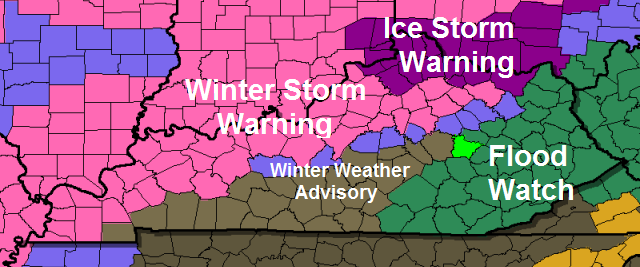
The snow pack will continue to play a major role in keeping temps down. Throw in a northeasterly wind and you have the makings of a ice storm in the north. The southern side of the wintry mess will be dealing more with a mix with some plain old rain…
I will also be watching the heavy rain threat across southeastern parts of the state. That could lead to high water issues.
The only thing left to do is watch to see how things play out. Keep tracking…

I-75 @ Winchester Road Lexington

I-75 @ Iron Works Pike Lexington

I-75 @ Clays Ferry Bridge South Between Lexington and Richmond

US 60 @ US 127 Frankfort

US 127 @ Frankfort Frankfort

I-75 at MP 36 London

I-71/I-75 at Buttermilk Pike Near Covington

I-64 @ 3rd St. Exit Louisville

Downtown Louisville @ 2nd & Broadway Louisville

I-65 @ 234 Near Bowling Green

Post the weather conditions from you live and take care.

Funny how you see snow in northern Mississippi in the radar loop and we are just suppose to get rain in EKY. We have the boats ready for this one.
Thanks Chris. Got my waders out! ;). You guys in the warned area stay safe.
Try a boat Coffee
Andy, working on that, but the wood is so wet I don’t know if it will hold together! 😉
yeah might be a bit of a problem 🙂
I know this is not going to happen, but I believe ’94 storm was suppose to be a ice event for metro Lou. With dusting of snow at the end. Hhhhhmmmmm…..see current forecast…….would love to see this all change to snow this evening. I know it won’t and we have a better chance of it turning to COLD RAIN!!!
THINK RAIN!!,
I don’t want a bad ice storm in frankfort, but 33 and rain is the worst weather on earth in my book, like Chris says, will just have to see what happens, have noticed dew points still in the mid 20s so temps might fall even if some areas go above freezing for a while!
Central Ky weather fact. 33 = rain 32 =dry 99.9% of the time.
This is such a now casting event to a tee. I-64 corridor could have rain,freezing rain,snow,sleet, thunder and lightning all at the same time very dynamic system. Watch out for dynamic cooling which could affect precip types. Example: You could be sitting at 30-31 degrees with freezing rain thunder and lightning develops temps drop by 5 degrees and your freezing rain becomes a heavy snow or sleet. Possibility is there.
What you think about us here in greenup county prelude!? We have about 5 inches on ground..I’m about 25 miles north of I64
Snow sleet on the onset maybe 1-3 inch should transition to freezing rain with a decent icing for your neck of the woods
How about us here in frankfort, prelude?
ARMAGEDDON!
That storm was very VERY powerful and dynamic. During the storm, Kansas City was at 11 degrees with FREEZING RAIN. The amount of moisture with that system was crazy. I don’t see anything like that happening anytime soon.
Now the NWS has moved the sleet/freezing rain line southeast into Lee and nearby counties. Aren’t we happy? 🙁
Just so I understand, for those of us here in Fayette County, the difference between rain, ice or snow is about a 5 to 10 degree differential?
Looks like a kid took a whole box of crayons to that map! So many different warnings and watches in one region, and they could all move north or south.
Flood watch will only move north it doesn’t know how to move south 😉
Just FYI, the forecast.io web app, which I have found to be scary accurate (down to the minute) for when rain will start and stop, is now forecasting 4-6 inches of snow for Fayette county.
I guess we just gotta wait and see with this storm
Temperatures better rise for rain in southeastern, Ky. Clay County is 30 degrees right now.
Yep. They may rise but they better hurry. We have gained 1 degree in the last 2 hours. And we are below freezing and the snow on the ground is holding. I live in Morgan County (southern part) and we set at 30 degrees at my place. If any cooling happens we could be in trouble even if it does go a little above freezing for a while.
When I went to lunch, temps said 36 where I am in Somerset. I know one thing…its is a VERY chilly, damp 36. Our local weather says todays high 34, tonight’s low 36, and tomorrow high 38. Kind of sounds wacky, doesn’t it? Just like the weather. Ha!
sitting in the low to mid 40s in Knox
I know our rain is not supposed to start until later tonight but on the radar it seems to be getting pretty close. Chris could that men we see even more rain than first thought? Just wondering.
Temperature currently sitting at 29° in Louisville according to my phone.
I have a question for any of you very knowledgable weather peeps out there.. I’m in between morehead and ashland and we’re under a flood watch; however, our temp has been holding steady at 30 degrees all morning. Should we be worried about ice? One county north of us is under an Ice storm warning.
I’m here with you Megan. Wondering the exact same thing!!
Yes I would till temps get above freezing
Any news on the weekend storm. 12z GFS still puts E ky in line for some snow. What is the Euro and the Canadian saying. never can find them.
I didn’t even bother attempting to look for the Euro, Jackson NWS is basically writing this one off per their lastest discussion. I think we have took the best of what winter has to punch.
Seems the ice will be more an issue South to where the map shows now rather than mix. Especially an issue if you have snow. Hoping my thoughts are wrong.
Thats what worries me. I am afraid more people get ice than whats anticipated. No science to prove it. Just feel it. Hope I am wrong
Bubba, I’m in between morehead and ashland and I am currently under a flood watch, but our temp is holding steady at 30 degrees (has been all morning) and we have snow and ice on the ground. What are your thoughts for this area?
Yep Bubba- fully agree. I just posted below. Looked at radar returns- the ice blob on radar looks much further south than the advisory in my county (Mercer). I am wondering if the ice is going to hit a lot further south than the warnings. Not good, not good at all. Unless current radar is Virga or shifts N/E it looks suspicious doesn’t it?
I really can’t imagine any significant ice getting more than a county or two south of the current tier included. Mets have been saying that winds should switch over from the NE to winds from the SW which should boost temperatures a bit as the low tracks through Kentucky, and ensure that even if a southern county starts as fr rain, it should end as a cold rain.
I am not saying South of the current map, but possibly more ice for the areas in the pink and blue. Especially the snow covered areas. As CB said, we are in Nowcast mode and the models are secondary now.
Richmond is right on the edge…. Think rain 🙂
The river won’t hold back ice. Snow maybe but not ice. That’s one of those Kentucky weather phenomena things.
Case in point, we have an ice mix right now at 32 degrees. Boo!
People to the north might get smacked, but Rolo says folks here are crazy and the rain is going to wash it all away for you guys. Winning!
Up to this point, we just gotta take a wait and see approach on this one along I-64.
I just see a typical winter weather to rain type of event for central and northeast KY. If you guys want heavy snow, go north
If you want balmy warmth with tropical rains and minus the hyped winter storms that never occur here anymore, come on down to southeast Kentucky. I’ll fire up the grill. Steaks and drinks to be served at 5, and we’ll have the pool and hot tub open this evening.
Now that’s what i’m talking about..yes sir…Any nice Babe’s around..
LOL, yeah, we’ll all being sporting our summer swimwear, since we don’t get winter in these parts lol
Mark my words…..Ice accum will reach 0.5 or higher along the parkways were they say rain/sleet/frz rain. Dynamic cooling will keep this stuff from changing to rain. This one is going to catch a lot of people off guard.
NWS in Louisville not so confident. They believe that temps from Lou to Lex might nose about freezing and that icing may only reach advisory levels.
Maybe at the two airports it might get above freezing. Go 500 yards in each direction of the two airports and its below freezing
We are still around 26° here in Nelson Co/Bardstown, with snow cover. I call our area “Ice Storm Central” because if it’s a difference between ice/snow/rain, we get the ice, no matter the forecast, esp if we’re on the borderline as we are now w/ the WSW. In ’04, we were expecting snow, but got a crippling ice storm while just 12-15 miles to our north, they got almost a foot of snow.There have been a few other “minor” times since then where we’ve had Frz. Rn. and it snowed just up the road a few miles…I’m prepared for this to include us even tho the maps don’t.
That’s my thoughts exactly. Too much snow on the ground!!
Chris Dynamic cooling will not be a factor at all. Dynamic cooling only occurs when their is very heavy precipitation. IF you have freezing rain falling at that rate, nothing will freeze because the water will pond too fast, making it harder to freeze over. IF you want freezing rain you need a steady, light rain, especially when temps are as close to the 32 degree mark as they are today.
Pretty hard to dynamically cool due to evaporation when the moisture profile in the atmosphere is so high.
I hope it warms really soon here in Murray. Currently is 31.5 degrees with heavy rain and sleet.
I keep watching the radar and looks like the freezing rain keeps pushing the rain to the south. I hope km wrong and I’m definitely no meteorologist, but it looks like a lot of people are going to get caught off guard with this one. Our temp is holding at 30 degrees and we have snow and ice on the ground.. Doesn’t look good at all :/
I always take precautions myself. As much as I believe the forecasts, and CB does an excellent job, there is no substitute for looking at the radar. My county is in the flood but our temperatures are lower than any forecast I have saw. 1:15 and still 30. And the radar does not look good. Considering the possibility of some dynamic cooling I am starting to think that ice may be an issue. Guess we will see.
No doubt- just posted same thing above and below the comments. Radar looks wicked and a lot further south for the ice track than the warned area. But, I am definitely not a meteorologist.
The radar looks that way for now, but once the wind direction switches from NE to SW, the warm air will start surging over our heads. The mets know what they are doing.
Looks like we’re on the snow/ice line here in New Albany. I’m hoping the snow cover will keep us cool enough to push that ice south (sorry guys) and keep us mostly snow for tonight. Here’s to wishful thinking.
Temp went from 28 on the south end of Nicholasville to 30 on the north end and has now dropped to 29 on north end.
Mid40s here in knott co
The weather less channel still says heavy rain for frankfort with temps rising to 36 tonight, they might be right this time but doubt it!
Soooo….I am in Mercer County in the WWA area just off the warning so was not too worked up about ice problem. Unfortunately, I just checked the radar and good grief- look at the pink blob coming. Now, sometimes we “see” snow on radar and it is the virga monster. How does that work with ice? In other words, radar looks horrible with ice right now with the pink blob headed what appears to be further south than the advisory area. Any thoughts?
A decent amount of the precip moving into Central KY is virga at the moment (can have virga rain the same as snow), I believe only Western KY really has significant precip right now. I think its supposed to start picking up for central KY around 4pm.
It is only 29 in Burgin right now . Just drove in from town and it is very a wet cold feel.
So, this might be a stupid question (no, this is most def. a stupid question) but is Eastern Kentucky pretty much going to go winter weather free for a bit? I have a baby due in the next two weeks. I just want to know what my weather plan should be. lol
Any responses would be nice.
This Sun/Mon looks promising for winter weather.
Thanks!
Won’t happen Mr Rose, we’ll either be breaking out the wet weather gear or watching a system that fails to phase and become anything meaningful
Bryant, there is no way you can tell that for sure this far out. Snowman Jones, definitely start making plans for winter weather for Sunday and Monday. Past few GFS model runs show some snow for Eastern and especially southeastern Kentucky for Sunday/Monday. At this time it doesn’t look to be a huge deal, but with a baby on the way I’d rather be safe than sorry.
Thanks! I’m in Floyd County so I’m thinking we’ll get something. Maybe nothing major, but something.
I wasn’t asking i was giving my opinion
Just got a call from my daycare in Hopkinsville asking kids to be picked up. Looked outside my office window and it is sleeting out there like nobody’s business. A few seconds later, a WWA alert comes on my phone until 5 p.m. I was expecting mostly rain, but I guess it got colder than expected with the ice cover on the ground (Had about .25-.5 of ice from Sunday storm. Many of the roads are still skating rinks.) Anyway, just wanted to mention it is sleeting further south than originally forecast. This morning, we were clearly in the rain zone.
Something else to remember just in case this happens and it more likely will just because Lexington and Louisville might report a temp of 33 or 34 with rain that temp most of the time doesn’t reflect a true temp once your outside the airport limits. In reality it very well could be at or below freezing were your at. Dumbest thing to take a actual air temp at a busy airport. I know that half of Louisville records a few years ago were broken during the summer heat wave I promise you that some not all would still be standing today if those temps were taken at the NWS office and not the airport.
Hey prelude, what do you think will happen here in Frankfort? Thanks. Just trying to prepare for long term power outage if necessary
I don’t think there will be widespread power outages maybe sporatic but nothing widespread dynamic system but it’s quick hitting. Like I said the I-64 corridor could see every sort of precip except for hail. We’ve been through worse.
Thank you!
Someone else agrees with me. I’ve been saying this for years.
Still sitting at 30 here in greenup
KY Mesonet says bowling green is 101% humidity. I don’t know what that means.
Your really underwater 😉
Been sitting at 30 here at the Boyle/Garrard border for several hours now. Hourly forecast said we would be at 38 midday and currently. Does this mean the freezing precip will hit us instead of rain? hmmm
Sure looks like a loaded sky right now over carter co. Temps are around 31 and not much has melted. We still have ice coating everything from branches to roadways….big ol’ pink blob on the radar headin our way. Snowman Jones please be careful and plan for any and everything.
Thanks! I will try. Winter weather is so unpredictable!
Mr. Goode from wave3 in Lou holding to a southwest flow really coming in from Louisville east to Lexington and changing most areas to plain rain, radar says it better or some METS headed for BUSTville with this one?
Are there any readers in Paducah area that can confirm precip type?
Hopkins County
Sleet/freezing rain
31.5 degrees with heavy rain and sleet in Murray. We were supposed to warm to 37 but it hasn’t happened. NWS Paducah just put us under WWA finally.
I’m no meteorologist (disclaimer: I did study meteorology in college for 3 years before switching my major, and this gives me NO more credibility whatsoever!) I for one am not too worried with this one for the LEX area. You all have to remember that the center of low pressure is moving northeast, which if you look at the radar returns and move it straight northeast, that will bring the low right over LEX, keeping us warm enough to avoid most if not all of the ice. I think intially we will have a bit of sleet and freezing rain, however, I wouldn’t think it will last long, even with a snowpack. That warm air will overrun in a hurry. Even if we sit at 31 degrees, the rain will be coming down so hard it won’t have time to gather a big ice accumulation on trees and powerlines. This setup is just not condusive for LEX to get a big ice storm. Nothern KY, southern Ohio on the other hand, won’t be so lucky. If I lived there, I would be making preperations for at least scattered power outages and terrible road conditions. Here, I think the biggest concerns will be a few high water issues where it commonly floods. If we can’t have SNOW, bring on the COLD rain! No ICE!!! As far as the weekend system goes: ????????????????????????? It’s amazing all the technology we have and you still can’t trust a model in winter!
Carter county is now under a winter weather advisory. This is a change from earlier.
In Etown. Ft Knox has already put all workers on a 2 hour delay for morning. They must think something is going to happen! We are still snow covered here.
I’m really trying to understand the temps vs NE flow vs SW flow. I get the concept as a whole, but how does dynamic cooling fit into that? Prelude? Anyone?
Western Hardin county holding steady at 28. Supposed to be at 34 now. BUT that shouldn’t matter right? If I understand the theory behind placement of warnings/advisories, then by later this evening, warm air will take over and ground temps will rise.
The way I understand it, regarding this storm, is that warm air advection will be the main player in temperatures being marginal . As it stands, this side of the Ohio river seems to be really on the fence in regards to precip types. I know CB is really hitting hard on the snow pack idea, but the NWS and other pro mets are suggesting that this will turn into all rain event, with the exception for far northern kentucky, where an Ice Storm Warning is in place. Also, current modeling suggests an an ice to rain event unfolding.
The reason for bringing the warning more south was to cover the snow pack areas that were not expected to warm up all that much this afternoon. We did not have any sunshine, and the snow on the ground would delay warm ups. The RAP model strongly showed this and that is exactly what we’re seeing this afternoon (temps over the snow pack are cooler than in areas without snowpack). If those near surface temperatures remain below 32, then we will see more freezing rain with the chances of getting 0.25 of an inch. It is possible that the warmer air aloft may work down enough to warm things in the snowpack above 32. That still remains to be seen…but it will probably be close.
Just started snowing here.
29 Degrees on New Circle across from Sams Club according to my car temp gauge. Dont know what that means, just letting you know!
Just curious. Which is more accurate, the radar on channel 27 or the radar on here? Both are showing different rain snow ice lines.
I was just getting ready to ask a very similar question. I have my opinion about which radar does the best job disregarding virga, but I’d be interested in what you more experienced weatherheads think.
Don’t hold me to this, but the WKYT radar is dual-pol, which should make it more accurate at distinguishing precipitation types. I don’t think the radar displayed on here has that upgrade.
Understand. Thank you.
Hey Nancy! Just saw the WWA for Carter Co. I was afraid of this.
temps in western KY dropping slowly.
calm down, no bust the warm air is coming northeast..geesh some u are crazyyyyyyyyyyyyyyyyyyy
ROFL…. I just had to post that….
You shared it 😉
Just heard a rumble of thunder here in Harrison County, IN
appreciate ya cris followed you when you were with wsaz, I travel from Pikeville to Lexington to work as a nurse at the va hospital . I can always depend on your predictions to get me to and from safely .
Same as Robby. Just heard a few rumbles of thunder, but in Oldham County!
http://forecast.weather.gov/product.php?site=LMK&issuedby=LMK&product=AFD&format=CI&version=1&glossary=1
Uh oh, the dreaded dry slot is being mentioned. Unless you want ice, and it looks like some of you do, this is a good thing.
are you in the Louisville area?
Nope Andy, London. Have family there and spent my first 30 years there, so I have an interest.
The weather channel has the storm for this weekend going to far east to affect Kentucky.
that’s because the GFS has the storm suppressed it will correct we are 5 days away
I feel for everybody that gets hammered with ice. It sucks I know. I am in North East Garrard county and have around a couple inches of snow on the ground and quite a bit of ice in the trees and on the fences. I hope it does warm enough not to have to worry. Good Luck all.
Seems like this this is blowing up, and in a hurry!!?? I ‘ve been watching the radar trends from OK/AR all day, and I think this is going to be a booger for even those not in watch/warning areas?!
For all the radar trends that seem to indicate more icing, it seems like the NWS and local stations are actually hinting at less to worry about. As someone said, NWS mentioned a dry slot working in later, along with marginal temps and heavy rainfall limiting ice accretion. WLKY also just switched their forecast to light icing for the metro area (down from .25″ I believe), with more north of Louisville. Will definitely be interesting to see how this all plays out, as CB seems more concerned.
I just noticed how it was building in and back as the afternoon went on…reports recently of ‘thundersnow/sleet” west of L-Ville and just west of me-I live in Nelson)
Still below freezing here in greenup
Looks like the show is over folks. (at least according to most)
Ya ain’t gotta go home but ya can’t stay here.
Hope it is as far as ice is concerned. Nobody needs that.
I think NKY will still get something significant, but most of Kentucky should be in the clear regarding anything too crazy.
The Cincinnati traffic cams should be fascinating to watch with this storm because the frz rain/snow transition line will go right through the city.
Several inches of snow are expected north of the OH river, not so much south of the river.
See the cameras here at this link.
http://www.ohgo.com/dashboard/cincinnati
Guys live in Ashland,KY and work in Huntington,WV. They have been calling for rain but the temps seem to be staying around 30 to 32 degrees. Has the forcast changed for this area? Chris miss you around here. Just wanted to feedback.
Thanks
Temp creeping up to 32 in Frankfort, unless temps fall some after precip starts this one shouldn’t be much to worry about atleast in this area!
Been seeing pink on radar for an hour in Louisville, nothing coming down. Temp 30 on my phone.
It will start soon. Snowing in Harrison county, in now. Has been for the last half hour
Thanks. Stay safe!
Lexington (or at least my area of Lexington) seems to be holding steady at 29/30 degrees (it has gone up and down between the two all day). I’m not buying into a big temperature increase with all the snow and ice still on the ground and daylight heading out very soon. Will be very interesting to see what we end up with.
Clays Ferry Bridge (over KY River on I75) Fayette/Madison Co line:
air-31.4 pavement 34.8 subsurface 34.9 humidity at 88%
Could be an interesting commute home for many folks.
Sounds like western KY getting more snow than anything else so far, interesting, may this low is heading a little farther east?
I’m currently in Ashland and it’s 34 here..my dad said it’s still below freezing at hour house in greenup
31 in Marion Co. with precip closing in. I don’t think we’re reaching the forecast high of 36.
WAVE 3 said that thunder sleet is being reported in Western Kentucky.
Near Henderson KY. We had about 90 minutes of moderate/heavy snow that covered the ground. Has now switched over to sleet and frz rain. Ugh! Was hoping for a much bigger snow!
Louisville just hit 32 degrees, and it looks like the freezing line is finally starting to creep North, if radar is to be believed.
Chris upped his Ice totals for Frankfort now up to .50 ouch!
Our temp here just outside of BardstownKY has gone from 32 to 29 in the past hour. Nothing coming down yet but we do have existing 3″ snow pack from a couple days ago.
32 degrees in Perryville. Boyle County is surrounded by WWA and flood watch, but nothing for us. The air is so moist, I think I might drown if I took a deep breath! Here’s hoping for one more snow day!
Sleet and freezing rain in western Hardin county with a little snow mixing in as I’m typing. My car is already glazed in ice. Coming down at a good clip. Temp still holding at 28. Here’s hoping warm air advection comes through. I was without power for 9 or 10 days in 2009.
33 in North Madison and Richmond town. Come on Torch! You robbed us from a good snow and now must protect us from ice 🙂
Kind of a quid pro quo 🙂
I am so sick of Somerset only getting rain! I know no one can do anything about it, but for goodness sakes, why can’t it snow just a little bit here?
Temp dropped back to 30 in east frankfort, made it to 32 earlier, something should be falling soon!
Temp has dropped from 33 to 31 at my house in Garrard County in the last 2 hours.
If anybody caught CB’s forecast I’d love to hear if he’s still keeping roughly the same snow/ice/mix lines that he’s forecast. Bout to head into work and live in Louisville so would love to know what to expect tonight even if I can’t catch him on tv. Thanks in advance.
He brought the advisory area a little farther to the south.
He didn’t seem to make any changes to what he has indicated here, but did say that he thought Madison County should be included in the Winter Weather Advisory.
Sleeting now
A few flakes flying around now. Outdoor thermometer showing about 32*.
Light snow in Louisville at the moment.
Light snow falling in Jtown.
That light snow is now a a pretty darn heavy snow.
I work in Fern Creek–the snow is coming down steady!
Ok it is absolutely crazy outside heavy snow and ice. Wind blowing snow and ice everywhere.
Currently snowing the best looking snow I’ve seen all season near the Highlands in Louisville.
And all we have is cold rain and ice mix in Richmond, so all is “normal”. 😉
Light snow in Shelbyville.
Yep…here we go.
Heavy snow now starting to fall in NE Louisville (Worthington Hills).
That hi temp of 38 that Wave-3 stuck with just didn’t happen. Neither did the 34 by the other stations.
It was 31.1 degrees when the snow started just 10 minutes ago. It was dropped to 30.2
It has happened before (Chris Bailey being the only one right) and it may just happen again.
temp down to 27.9 now at Westport Rd/Gene Snyder exit NE Louisville. 3.2 degree drop in 30 minutes.
Lots of ice combined with the heavy snow, you can hear it pinging off of everything! Road is covered in about 10 minutes.
Now a real thin sleet coming down. These roads are going to be terrible.
Looks like the rain just about ready to get here (Knox). Some high water issues likely after a soaking rain super bowl Sunday and now another big rain tonight.
I’m giving winter one more weekend to give some snow starved people in Southern an SE Kentucky a little snow. After this weekend (not that it matters though) I am officially finished with the cold and winter. Less than three inches for the year in one of the coldest winters in years. Would much rather see warm and sunshine. At least you can get out and enjoy the outdoors (beats the rain). On a side note, when is meteorological winter over?
March 1st
Where i live in se ky we have had at least 5-6 inches and several dusting
Nothing but freezing rain here in Ohio Co, can see accumulation on power lines n trees already.
Wow…really snowing outside! Some sleet mixed in with it.
wind is howling and freezing rain coming down hard. definetly freezing rain in etown. temp has held solid at 28 for hours. courious to why temp has not risen?? anyone ?
So i suppose flooding is no longer a concern no green paint on the map
I was wondering that as well. River is out of the banks and creeks way up. We had been in the flood watch but are now in the winter weather advisory.
Was there ever anything called for on the backside of this for tomorrow? Do not really remember.
Heavy sleet blowing around near Iroquois Park in the metro.
Now heavy snow is falling with some sleet mixed in.
And when I say heavy snow, it is REALLY coming down hard. Roads are covering over quickly and the wind has picked up. It’s nasty out.
In Bardstown (city)…had a brief period of heavy sleet, now it’s a mix of moderate/heavy mixed snow/Frz. Rn…..coming down pretty good! This might be a “booger”??!
We made the switch to all sleet very quickly here in Louisville and it’s coming down heavy. It’s going to get pretty nasty here REAL quick!
Just started sleeting in a fairly determined manner!
At Clays Ferry
Freezing rain in NE Garrard Coubty. Thought it was interesting when CB said we may have a hard time changing it over to all rain. This is one time I hope he is wrong about that.
Dry layer around frankfort, radar is juiced but nothing reaching the ground?
A few sleet pellets starting!
Transitioned over to all freezing rain now, coming down slow and methodical. Isn’t that the kind that CB said we didn’t want?
30 degrees here with a sleet/freezing rain mix.
In the last hour, we have had snow, sleet & rain here in south Lincoln Co. We still have quite a bit of ice still on the trees and power lines from Sunday night. I’m quite concerned about how that is going to affect things.
Sitting here on this dark miserable day watching it rain. I am sooooooo glad that I did not buy a shovel or snow blower this year. That would be a waste of money. However…….I looked out my back window just in time to see Noah gathering the animals onto the ark. Time to move to the roof. I will just keep wishing and praying…..”Maybe next winter”. Have a good evening e1 and be safe out there. I might hit a puddle of water and hydroplane and make me think I am sliding on snow……hmmmm sounds like fun. Wanna go hydroplaning with me Andy. LOL
Jay Cardosi on WLKY just said the snow is over for the night in Louisville. Just freezing rain and a bit of sleet here on out.
I respectfully disagree. It will go back and forth between snow, sleet, and freezing rain. He did say Louisville and counties bordering the river could see as much as 3/4″ of ice! ouch…
well in etown it is still 28 degrees and coming down hard! sticking to everything!
Ice pellets coming down with a vengeance accumulating rapidly in west Frankfort. Nasty stuff.
Big snow flakes mixing in Frankfort, would not trust Louisville METS they are struggling, Chris is the man again!
I think Belski has been pretty spot on these past few days.
Well, southeast Kentuckians, the news gets worse. Jackson has very little confidence on this weekend. System is disorganized, model runs all over the place. And, big time warming trend next week. I’d say this is the last of winter.
Not entirely.
MODELS REMAIN IN DISAGREEMENT REGARDING THE NEXT WEATHER SYSTEM TO
IMPACT THE AREA THIS WEEKEND. WITH THAT WILL PLAN TO STICK WITH A
BLEND OF THE MODELS WITH A MIX OF RAIN AND SNOW AT TIMES. DEPENDING
ON THE TRACK WE COULD SEE A BIT BETTER SNOWFALL…BUT OVERALL SYSTEM
SEEMS RATHER DISORGANIZED AS IT CROSSES THE AREA THIS WEEKEND…SO
HEAVIER AMOUNTS SEEM IN QUESTION.
Yeah so what you said is true but you forgot to include the rest.
Well done CoalMinerD….a good way to squash yet another negative comment.
So, back half of February and all of March we will finally see blowtorch warmth.
Sure–just like we did in January 🙂
Freezing rain in Lexington! No sleet, or snow in sight. My deck is now glazed over, its VERY slippery, let’s hope things don’t keep going this way. But roads are fine though.
Enough snow to coat the road and then switched over to freezing rain here at Westport Rd/ Watterson x-way. Everything glazed over now.
Appears to be just rain in Lansdowne area of Lexington..
I live in Cincinnati/Northern Kentucky area and looking at the radar above we should be getting pounded with snow. Nada. Temps never made it above freezing and is currently at 31. None of our met’s have backed off on the ice accumulations for our area. Up to 1/2″ with 3″ snow beforehand. Turned the furnace up to extend the warmth for a bit if we lose power. Wine…ready. Pizza in oven. Grille by back door and covered. Ready. 🙂
Appears to be falling as rain here too in this area of Lexington but I think it’s deceiving as it is freezing fast to everything. Our porch is already a sheet of ice!
Had a VERY brief period of sleet/snow in Lawrenceburg now nothing and nothing on the radar. Good–keep the ice away.
Arrgh!!!!!!! Raining in Lou metro melting my 4″ of beautiful snow.
it isn’t melting any of our 5″ over here on the NE side…
All it is doing is creating a coating of ice on top of it all, along with sleet pellets.
We are getting rain. It’s freezing metal surfaces but slush on other surfaces.
Sleet just starting here in Carter County!!
29 in Lawrenceburg still with 4 inches of snow on the ground. We had a small burst of sleet/snow and now nothing. Radar returns keep a dry slot/light precipitation over this area for the next several hours. I am all for that. Don’t need any ice.
I think I’ll watch the ‘Cats play and then check back in on the radar at half-time…nothing to see here for awhile!
Sleet is pouring down here in southern IN just north of Louisville. We will be able to measure our sleet in inches if this keeps up! I love to follow this blog. Thanks to Chris and all who post here.
Seems like more of a cold rain here in Jtown now. We have seen all of the different types of precipitation so far! CB was spot on with that one too.
Still freezing rain in western Hardin county. Trees and power lines covered and icicles forming. On a positive note, temp has gone up to 30. Never thought I’d say this in a winter weather event but keep the warm air coming.
Snowing in Boone County!
Waa expanded south.
I think I’m going to head to sonic and get a large dynamic cooling and a side of fries and watch it pour the rain.
I definitely learned something today!
I did NOT know that rainfall rate had anything to do with Ice accumulation…..I guess I just thought freezing rain has always been coined “rain that freezes on contact” (instantly)……..Never thought about it needing a few (moments to freeze)
I do remember the bad ice storms we have had in the past in Lexington and the radar. The radar was stretched REALLY far both times. It looked like a constant stream of moisture from the southwest to northeast almost stalled moving over the same areas (unlike this storm)
And about the MESONET! Can you believe it? Another event and it’s not working! Watch during our boring weather with temps no one cares about (in the 50’s or something) and it will be working flawlessly!
Same here, thought the same thing.
Freezing rain is now falling steadily here in Olive Hill.
Wet snow beginning in Cincy/NKY area. The fun begins!
Quick burst of snow has given way to sleet now in Union, KY
I don’t know Rolo, looks like a lot of “crazyyyyy” people are getting covered in ice. That there warm air you stated so absolutely, had better absolutely show up……………… Nope, still not there.
I’m doing alright in the ice zone. 28 in Lawrenceburg but a persistent area of light precipitation/dry slot keeps coming over my area…looks to last for awhile. I’m not complaining!
One of the few times a dry slot is a good thing for winter 🙂
I thought Bill Meck said this would an all rain event. Reminds me of that song,”Things That Make Me Go Umm”
Bill Meck is still saying it’s going to get to 37 degrees overnight… and it’s 29 in my area of Lexington right now… that’s a LONG way to go!
All joking aside, if the low moves through the area, it should get warmer. Questions are when, or is that happening and will it get us that warm.
I prefer snow events since Rolo is more fun then.
Yeah, I worry because according to all forecasts it was supposed to get to 38 today and our high was 30. It’s 29 right now. If they were off that much earlier today, can they really be on top of things with this low?
Not saying that it’ll reach 37 but the Fayette Mesonet site (http://www.kymesonet.org/live_data.html?site=LXGN) is showing a gradual warming trend over the past hour. At 6:45p, it was reporting 29.7F. At 7:45, we’re up to a balmy 30.3F. If the trend continues, we’ll be out of ice danger in a few hours.
Warming trend continues. 30.6F at 8:00pm. Winds still from the NE, though.
The night is still young, so perhaps warmer air is coming in as some has mentioned? CB stated he thought the impact might be more than expected and moving the mix line south. Seems that would not be a good thing for the north.
Warm air cavalry or a mega dry slot to save the day? Think dry slot and rain!
Bubba the warm air is on the way. Here in London it’s warmed up 3 degrees to 37 in a little over an hour and looking at the hour by hour breakdown it is supposed to be 45 by 1am
Jim, how’s this epic winter treating you? I’m loving all these 34 degree rain storms here in London. Keep em coming boys
Lots of icin’ in Lincoln. Even my french fried taters are icin’. Ummm HMMM
NowCasting has added a batch of counties to the south to a WWA. With the temps below freezing all day, you’d have thought those counties would have been included in the original warning. Ice accumulations building in Lincoln at 6:50 PM ET.
Sleeting in greenup
freezing rain, sleet mix in Lextown. roads are deceptively slick….
Still a light steady freezing rain in NE Garrard Coubty. REALLY building up on most surfaces adding to what we already have. Heard reports of power flickering in Southern Garrard and power out at Stanford Wal Mart. Not looking like a very fun night.
I jest went out and chipped off sum ice off my lawn mower using my sling blade. Now i am gonna eat me some potted meat and sody crackers. I am gonna drank some coffee too even tho hit makes me a mite nervous. I like the way you bloggers talk.
Don’t forget yer mustard and french fried potaters…. mmm hmmm.
Thank ye. I like the way you talk.
That’s purrtatuurs…lol
Ice is hanging from everything here in Jeff. County KY. not looking good
Chris my car is iced over here in west liberty
I stepped in 2 inches of mud here in London, boy this is a winter to remember for sure. I’ll take some cool pics of the mud and puddles for you guys.
Confused why we are under a wwa until 7:00 AM if temperatures are forecasted to rise to 38 degrees
Heavy wet snow here in Cincy/NKY area. Visibility 1/4 mile. Winds kicking up. About 12 ” snow and it’s really starting to come down now. Can hear it hitting things outside and looks to be a mix of sleet and freezing rain.
Latest models kick up the snowfall amount in our northern counties to 14″. We’ll see if that pans out.
Ice is coating everything here in Jtown!!! I pray we don’t lose power!!!
Lots of sleet mixing in shepherdsville. I think this will help slow down ice accumulation which is good
March of 2003 ice storm hit with temps around 34. Right now we have an ice event and it’s 31. Just hope that the temps do rise overnight because this storm seems to have more moisture. Either way, we have a mess.
How do you get ice at 34? I was in Lexington for that and it wad 27-30 degrees.
I don’t think this is going to a February 2003 event in the Lexington Metro. Nor a January 2009 event. Both storms were more prolonged with more moisture and colder temps. I’d even argue we had a worse (but forgotten) ice storm in January 2004 because it paled in comparison to the one in February of 2003.
Etown (Hardin County) covered in ice. Sleet/snow/freezing rain coming down hard. School already cancelled for tomorrow. Roads very dangerous.
Also know that power has been in and out in parts of Caldwell and Trigg in western ky.
Started as snow/sleet here in the Ville a few hours ago, now steady freezing rain. According to local mets, we are at least .20 ice now. Tomorrow morning looking good here.
‘Sarcasm’. :o)
Freezing rain here in greenup..my porch is pure ice
Bardstown…don’t know the temp, but it’s dang COLD….HEAVY Frz. Rn. right now….10 min’s ago, was just rain…everything is coated heavily now….wow!
Pouring freezing rain here in Lexington!!! None of the 4″ of snow is melting! What I see is happening is that the drizzle and fog earlier created a thin coating of ice ontop of all the snow and when the rain started coming, it came slowly and gradually making the layer thick. Now it pouring rain and none of the snow is melting! Looks so cool just because I’ve never seen it rain so hard and a thick snow cover NOT melting, even my snow covered road is STILL completely snow covered!
Yes. same here it’s creating an ice crust on top of 5 inches of snow from last storm
Power just flickered in NE Garrard.
I can tell you one thing, it is COLD up here on the ridge in greenup..trying walking to our garage, pure ice
Well, my dry slot is gone. Temp at 30 with what I would call moderate freezing rain in Lawrenceburg.
Have to say, impressed with CB as always in Louisville. Just got sent home early from work this evening, and it looks like his thoughts on temperature profiles were more accurate than just about anyone. Freezing line continues to lag south with at least 3-4 more hours of freezing rain on the way in my parts. Already a few trees with limbs sagging to the ground in my neighborhood, though roads were mostly just slushy on the way home.
iceing up fast here in athens oh temp at 30
still have about 6” of snow cover as well
So my local news and weather come out of Louisville and like always, those counties southwest of Jefferson are an afterthought. I just watched two local mets completely downplay the fact that power is off in part of Breck county due to icing. The power outages are 15 miles west of me. Our local radio station in Hardin county went off the air because of icing. It’s like being in an ice storm in a vacuum. Maybe the warm air surge will change everything to rain at midnight but does that really matter if the power is out? It’s still 30 here. Still freezing rain. Still icing everything, including my snow-filled gutters. I have Niagara Falls pouring over my garage doors trying to form icicles on the way down. I know most of the posters on here are east of me. Just an FYI about what’s going on at this end. Winter storm warning was accurate for Hardin county.
Ice covering bushes and trees. Little icicles hanging off the sides of my porch roof.
Still icin’ here in Linconl.My outside lite was iced. I gave it two good whacks with a lawnmower blade. The second one nearly cut it in two. It don’t work no more.But it ain’t got no ice on IT!
Saw a nice compliment for CB on the Tweet sheet.
‘Weatherman of the Year’.
I thought of another one….how about WOW?
Wizard of Winter
The mighty WOW has spoken…
Keep up the good work sir.