Good afternoon, weather weenies. Snow showers and flurries keep on doing their thing across the region. These are putting down local accumulations up to a half inch and creating additional travel troubles. As we look down the road toward the weekend… I’m tracking… wait for it… wait for it… more snow.
The first system moves our way by late Friday night into Saturday morning with a band of light snow increasing from the southwest. The NAM is finally seeing it…
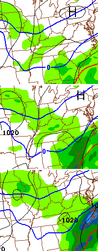
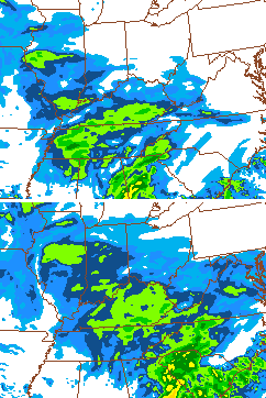
The Hi-Resolution version of the NAM shows a pretty impressive future radar…
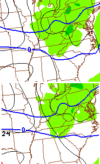
That has the look of a Saturday morning snowfall across much of the region. The NAM is also picking up on the Sunday batch of light snow…
Sorry, but I’ve had my share of winter and am ready for spring. Unfortunately… we have a ways to go before that can happen. Yippee.
Take care.

I love snow, but I’m done. Been out of school/work for a week now. Spring, please.
Thanks Chris. We’ve had the cold but not the snow. So since it is still early February, I can’t help but hope for a good snow before winter is over. But whatever happens, spring is not far away…..maybe. 😉
no harsh winter for us Coffeelady but maybe we can get a little action before its over
Chris you’re whimp
Well i guess us Southern folks can have your sloppy seconds since you have had your share. 😉 Thanks Mr.Bailey
ever heard of beating a dead horse? yup, you are there. we get it. you haven’t had snow. if I could give you the snow and ice we have had just to shut you up I would.
Oh my word Miss Kate I so agree with you. Andy must not have a life, job or friends and it’s no wonder why all he does is whine and complain!
chill out!!# literally
Chill chill! We are all friends here!! Andy has missed out a lot this winter, he deserves a good snow
What would it take to shut you up?
No disclaimer here, sorry.
Bye bye!!!!!
Miss kate needs a chill pill
Back. Off. You are still a newbie and Miss Kate is, well, Miss Kate and has been a citizen of the blog for years.
I’m sorry to disappoint you but I have been reading the blog since he started the first blog that he had before this one.
lol.. telling me back off is so internet gangster haha, Excuse me, didn’t know we need a citizenship to comment here.. haha
hey! this is a club, not a gang! we don’t need no stinking badges!
I agree. We get it Andy…no snow.
I am completely chill. I just don’t see the need to relentlessly moan and groan about how little snow one has. or to continually remind anyone that comments on how much snow they got or how much is coming that they don’t have any. we get it already. but none of us, including the great and powerful Bailey, can change that.
Kate — Goodness, lighten up. Griping and complaining, moaning and groaning and a bit of bragging and sharing around the presence or lack of snow is part of what this site has been about since about 2007 when I first started following it. If one doesn’t like that one can always go some other yard to play.
Guess what Kate, Andy has every right to voice his lack of snow, just as everyone in the northern half of the state has the right to brag about how much snow they have had. You see, by your reasoning, those who have continually gotten snow all winter (some have literally rubbed salt in the wounds of those of us who have had very little) should keep their mouth shut too and that is not the way it works….everyone should have their voice. Enough said.
LOL
Wow things are getting fun. I happen to agree with all of you. Andy has his right to post. Of course others have the right to say they are tired of seeing it. The only person who could say much is CB as it is his blog.
I do know some that used to read the comments section here and because of the negative comments all the time have quite reading. When you see people post about wanting snow only to have the same group post about how it will not happen or some variation of the same thing that does remove the desire to read. And those types of comments do dominate this comments section. Much, much more so compared to when I first started reading here a long time ago. Used to be some fun insights to read into and even some other trained weather people posted. Now there is a lot of wading through the negative. And occasionally the back and forth like this current section.
Anyway, I hope that Andy and his other SE ladies and gentlemen can get a nice snow. Cold with mud just is not exciting. And can make for a long dreary winter. I also hope that all this does not make some quite posting. Love to here about your weather either way.
The next two weeks look menacing. Below normal temps and stormy.
agreed….just don’t tell WHAS-11. They are the complete opposite.
I just finished watching the midday weather on Whas-11. When will some of these MET’s learn? With the pattern we are locked in and with how the models are struggling to play catch up with every single disturbance, (just as CB said eluded to) he proceeds to put up an irresponsible model that shows the entire regions “total” snowfall for the next 10 days, all the way to Feb. 16. The most anyone had in Kentucky or southern Indiana was 3″ for the entire period.
Maybe he will be right. But, I would go with the odds and say, he will not be. Most likely, he will be changing his tune in the next 24-48 hours and most likely will act like he never said it.
I hope everyone realized how lucky we are to have Mr. Bailey, in a time where it seems more and more MET’s are giving lip service and just reading an output of one model that is the flavor of the month, and giving that as their actual forecast. Yes, Chris gives us eye candy models. But, they are never a forecast.
I’m rather disappointed even in a few MET’s who have been very good in past winters. But, this year, they seem to be struggling and going more with the majority, rather than giving their own perspective, even if it IS against the grain. Maybe I’m wrong. It just seems that way.
One thing is for sure…if you are going to tell everyone “NO major storms over the next week”, then you better be 100% sure on that. If you aren’t, you can easily say “there doesn’t seem to be any major storms impacting the region over the next week, but we are watching an area early next week for possible development.” Is it THAT hard?
I am surprised Chris’ Moderation Monster allowed you to post that.
It needed to be said. What can I say…winter weather excites me. haha
Elizabethtown City Police sent out a message for residents that the city is out of salt. A delivery is not expected until the end of Feb. It asked for residents to be patient and drive carefully since the roads here are a mess.
So, no school until March?
If you want a correct forecast you had better not pay attention to anyone but Chris Bailey. He is the best!
Absnowlutely the best! Where would we be without you, CB?
as a longtime reader of CBs back from his wsaz days…im actually in the spine of the mts near Beckley WV …were not snow starved or anything like ive read from alot of people and i understand it bc winter is supposed to equal snow ….we had about 2 inches of snow last night..rds were really slick with the snow/ice and as i put my kids on the school bus , what do i see…chains on the tires..wow ..what a concept …will def cut down on snowdays…and missing school over an inch or too
I am a complete dummy on these models i thought green meant rain and blue snows
Right there with you Willie. I just try to read the blog and all of the expert comments from everyone and try to keep up 🙂
The colors on the Hi-Res NAM simulated radar represent the severity of the precipitation. Blue is less precip, green is more.
The first map shows precipitation, the darker the green, or if blue, is the intensity of the precip. This map usually shows the rain-snow line by the blue line showing the number 0 on it. North of it means snow, and south of it means rain USUALLY but not all the time. (Because of other things like sleet, freezing rain, etc.) The second map DOES NOT show precip type, but only intensity. The blues are light precip, and green is moderate, and yellow is moderate to heavy. And the last map is same as first.
Last night the GFS was showing a Blizzard for Eastern Ky and now this..LOL…Not complaining because we all know how models are..Just find this Map a little humorous..Hopefully it will change back to earlier thoughts..
http://mag.ncep.noaa.gov/data/gfs/12/gfs_namer_159_850_temp_mslp_precip.gif
You never know with this winter. But we can hope.
Note to self: prolonged cold/snow periods make people grumpy
Probably getting their power bills from last month.
I’m ready for spring, but that doesn’t mean I’m done with winter. I’m happy with whatever we’ll get whether it be be cold, snow, warmth, storms, etc. I don’t think I’m the person that could get tired of winter weather, and thunderstorms also, but summer is a different story.
here is a pretty cool breakdown of the winter so far.
http://www.wlky.com/weather/regional-seasonal-snow-totals/-/9367530/24327956/-/q9b0xd/-/index.html
Looking at that you can understand why some snow lovers in southern and seast Ky are so frustrated,
Covington 37 inches
South east 1-3 inches
Wow, location, location, location!
2 hours drive north of snow starved seast 3 feet of snow??
Richmond area, well my backyard anyway, 10 inches.
Leave Andy alone. Sheesh…
“Sorry, but I’ve had my share of winter and am ready for spring.”
Is there a winter weather version of “affluenza”? I’m just 30 miles from WKYT and sitting at about 1/3 received of the snow that was forecasted thus far (9.75″), but there are plenty of people in the area who have received close to nothing over the course of the season so far.
Here’s a crazy idea, how about we keep hoping for more snow for those areas so that everyone gets a nice taste of the action at least once or twice?
Snow-starved folks deserve to see some snow love, but that’s not something that any of us can do anything about! Chris is a weather forecaster, not a weather maker! The incessant whining over the lack of snow in some areas is really not good form, guys. 🙂
here here!
Hopefully these system moving through are over achievers. Would love to see a few more inches on the three still on the ground. Feb will be the same until end of month. Cold and stormy…..
On March 20, at 12:57 P.M., I will be ready for spring. So until then… Bring on the SNOW and COLD!
Amen. 😉
Well I’ll tell you all like my grandson tells me. ( Well Nana it is what it! )
So I’m gonna be happy with what ever.
PS : I do love snow!!!!!
Wonder how many schools will have a spring break this year, atleast the ones that’s been in the Snowey areas??
Knox county and clay county have already canceled sb
Knox is on plan b
For tomorrow the cancelled spring break earlier
yeah found that out about a week or so ago 🙁
Are you a student or teacher?
Radar starting to look a bit interesting.
I think so too! Anyone else have any thoughts. Could that little system in Tennesee swipe through parts of southeast Ky?
Bring on spring!
ok, I have researched all day long and can’t find this radar technology anywhere. If anyone knows, please let me know.
It does a great job of distinguishing between freezing rain, sleet, and snow.
C:\Users\whitesxfan2012\Pictures\BfpxaynCcAAEUYW.png
not really sure that will even show up
http://twitter.com/JeremyKappell
try this….scroll down to Feb. 4th and eventually you will see a radar snap shot. Love the colors.
I like the part where Chris says, “Wait for it … wait for it …” The response should be, “What … do you think I’m Quicken Loans?”
All humor aside … Andy, I for one do feel sorry for you. Keep smiling and stay witty.
Or, Wait for it, wait for it….. the remaining half of the state again- not much (if any) snow for you! 😉 Gotta laugh, since what else is there? Surely not snow.
Chris get back over to our side we love the snow Chris we all need to have a little talk sessions with you…lol we love ya Chris
I am so done with this winter and snow, I never did like winter time and this is making me hate it even more…….:-D
I know what you mean! The pictures and TV shots of the snow are tiring new out 😉 🙂
Me. At least we got a 24 hour wonder. A lot of folks have gotten almost diddly.
Looks like Tennessee is getting snow today.
WBIR Knoxville says “a dusting to a coating” for areas south of I-40 and north of northern Georgia.
Looked outside here in Sevier County and surprised to see a coating on my deck, and still snowing. Sure didn’t expect that.
Well, these are comments that I can show my students tomorrow – NOT!! Can we please just comment on the weather and not people??? Gee whiz!
ever thought of redaction.
they can learn the weather and learn how the legal system operates at the same time
No, but perhaps I can turn it into a social skills lesson! 🙂
I’m a long time resident of southeast KY. Lived in Laurel and Whitley counties from ’81-’03–moving there from Boone county. It’s one of the reason I’ve followed this blog from the beginning, although I’ve just started posting lately. In any event, I can attest in southeast Kentucky, it’s either feast or famine when it comes to snow. I remember many years when we got the lion’s share of snow in the state, and other years where the track of every storm left us with “sloppy seconds” while the north and west were the big winners. Each year is different. I’m sure at some point Andy, Coffeelady, and others missing out now will be bragging about their snow, while others beat the drum of being deprived. Hang on Andy, your day will come. And you know what they say about paybacks. 🙂
Forgot to say…I now live in East Tennessee, and we got 4 inches of snow last week. 🙂 Not braggin’. Well, just a little.