Good Thursday, everyone. A monster of a winter storm continues to roll up the east coast and this is delivering a pounding snow to parts of southeastern Kentucky. As that snowfall winds down, we turn our attention to the next snowfall that rolls across the state on Valentine’s Day. Yep… some snow for all the lovers out there.
Let’s start with the snow we have across eastern and southeastern Kentucky. Some areas in the southeast will be measuring double digit snow amounts before this winds down early this afternoon. Hopefully me fear of power issues won’t come to pass, but that is a lot of wet snow hitting the mountains. Here’s regional radar to track the impressive action…

The system working across the Tennessee Valley on Valentine’s Day is likely to be a fairly widespread snow producer for much of the state. Here’s how the GFS sees it…
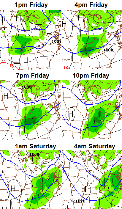
My first impression of this is a 2″-4″ snowfall, but it has the potential to grow into something more. I will get you a first call out later today.
The air behind that could send us into the single digits by Saturday morning. That will be just in time for one more light snow system to swing through by the evening hours. That one could lay down additional accumulations.
We start to break out of this pattern by next week as temps take off by the middle and end of the week. I think it’s only a spring fling and the GFS Ensembles show why…
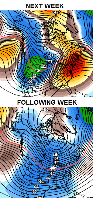 The last week of the month into early March has the look of producing some decent winter systems.
Take care.

Dont have twitter, so cant post any photos. I would love to though probably 8 inches now in Harlan County. Beautiful snow, stuck to everything it fell on. Pretty cool to see the whole mountain side reflecting all the street lights. Still pouring down.
“Fist” calls are awesome.
about an inch in southern Breathitt co. Still light snow showers do not think we will get to 2″ unless back end fills in. Buddy of mine lives in Harlan Co he has a little over 9″ as of 3am. said it was starting to taper off finally. 351 in Perry w/o power mostly in Southern Perry.
Light snow in e. carter co. 30 degrees ….some snow on the roads.
Yep.. It’s hitting us on the spin… Lol
We are getting light snow but so far nothing that looks to accumulate.
As of now it looks more like frost on the steps.Temp is going between 28 and 30 degrees.Wind is blowing a bit at times.I will not be at all disappointed if we get nothing tonight or today since I have appointments and won’t be able to get off my hill if anything sticks.
If we get a Valentine’s Day snow I hope its later in the day on Friday.
Hopefully people will be home safe and sound before anything hits this area.
Looks like anywhere from 9 inches to a foot here. Trees are sagging away down and the power has flashed on and off a couple of times.
*way
6 inches this morning in Raccoon near Pikeville.
As usual, not one flake here. 🙁
Don’t know where the long term model with more cold air came from. According to most long term models, the wicked winter is pretty well over after this weekend. I say bring on spring…
Got a decent ankle biter round 4 inches
Sorry Andy but based on what you’ve had in the past I wouldn’t think you would consider 4 inches an ankle biter.
Still gets just to the ankle so it cant be called anything else lol its still the biggest snow of the season
Andy, surely you are happy with this!
Yahhhh! Very happy for you, Andy! It took all season, but at least this one did not disappoint. It would be nice to get a little more before the season ends.
Andy got snow. Yippee. Just joking I felt your pain over the past two winters on the no snow train. Hopefully it sticks around for you until Friday’s snow and you get snow on snow.
That would be nice
Congrats! We may have you beaten with total snow but you’ve had a bigger single accumulation than we’ve had in Berea this year.
Still snowing in knox county so we may do better than 4″ they may have cancelled the advisory too quickly. Yeah hopefully no major meltdown today and tomorrow before the next one would like to enjoy this one. This is like the snows we used to get here when I was a kid.
I guess we are getting a bit more than I thought in Laurel county.Just saw that schools are closed today.Snow is light but still coming down.The sidewalk and porch has a dusting on them.
Here in the southern end we have well over an inch.
Still snowing has to be at least 6 inches or more.
Snowing nicely here in carter co. Must have almost 2 inches now. No school. Chris said we could get an inch or so. Way to go Chris!
A “knee” biter in Dorton this morning, still snowing and 10 inches in Pike County.
Family in WV is on track for 12″ from this system. The funny thing is this single storm will allow them to beat Berea’s TOTAL snowfall for the season of 11.5″.
Exactly 4 inches here in Carrie of knott county
We have about 4 inches on the ground in Charleston and it’s still coming down hard. WSW has now upped their amounts to 5-7 inches for the area. Roads are the worst they have been all year.
Still snowing in northern Clay County. We got about 2 inches on this end of the county. Anyone out there on the southern end of the county? How much did you get?
Andy glad you got snow. Now if we could just get some here in Somerset it would be nice. Thanks Chris for all you do. Everyone who got snow, be safe and please share pictures! Have a great day everyone.
About 0 inches in Somerset. I don’t want to hear Andy complaining.
A big fat zero huh….Andy is probably smiling this morning. 🙂
We have about an inch here now.Still a fine fog like mist going on.Hoping it moves on out soon.
If you ever see a post from Andy and he isn’t complaining or attempting to be sarcastic then it’s an imposter. 😉
Because of the freeze-thaw cycle, the icicles here at my house are HUGE, probably the biggest icicles I’ve ever seen! One of the 3ft long icicles from the side of my house fell into the ground from a height of about 20ft and stabbed the ground, its about a foot deep into the dirt!!! I measured it diameter and its about 3 inches thick at its base! Can’t even wrap my hand around it.
Around 4 inches in southern McCreary
14″ here in beckley wv …..still pouring ….funny the nws started yesterday morning at 3-5 ..and every update after got higher …2-4 more today
6 inches or better here in the Topmost area of Knott County and still pouring down. LEX 18 had us in the trace-2 inch range….Thanks once again Mr. Chris Bailey!
not sure how much snow we have here in morgan co looks like maybe 2 or 3 inches lot more then what we was suppose to get got a surprise when i got up….
Chris – the Huntington weather folks said Ashland would get some flurries that may stick to some cold spots….we have 2″ and it’s still pouring….you win again!!
Way to go Chris!!! You are the only weatherman in my neck of the woods that predicted northeastern Ky would get the tail end of this system! Woke up to a beautiful 2 inches and still coming down in Raceland!
Very heavy snow coming down once again, I’m guessing another inch or so has fallen in the past hour.
8 inches at Belfry as of 8AM and still snowing pretty hard.
This has been a great winter for Chris. He has nailed just about every system. He called for ice last Sunday while most other mets called for rain only. In fact I think one met guaranteed that it would be rain only. So much for the mets calling this blog a hype machine. Keep up the excellent work, you certainly have earned some recognition this winter.
Almost 7 inches at my mother’s house in Knott Co and still pouring..Snow feel’s wetter as it pick’s back up..Power flickering on an off..Gotta luv it..
We have 4 inches of snow at Denver, ky in johnson county & still snowing hard!
this storm is an over achiever in wayne, wva……..they were calling for an inch or less and we have at least 3 inches and going for four with the snow falling heavily for the past hour and a half and still snowing heavy……i think this storm pulled more westward over night.
The super duper cutoff line must have went right through the county, we only have about an inch.
For the snow storm we weren’t supposed to get, it has been snowing for about two hours or so here in South Ashland. We have maybe two inches but maybe more than that before its over at the rate it is snowing. I am not disappointed. I love the snow!!! It is still falling and from what I see of the radar, we still have a ways to go before it stops. Thanks Chris for all you do. You keep us informed when others don’t. Like I said in one of my past posts…I have followed you from Ashland to Lexington and will keep following. Have a GREAT day!!! God Bless!!!
Definately surprised this morning. I live in Grayson and work in Ashland. 3″ in Grayson when I left. Eciting drive! Its a whiteout in Ashland right now. Turn on our camera Chris!
Dodger says overachiever coming Friday. I LOVE snow on V Day!! Dodger!
Spoke to my father in Brevard NC (western) and he said they received 10 inches of snow.
Incidentally , check out the charlotte webcams! The Main interstates look just awful…….they really must not do much road treating……
http://www.trafficland.com/city/CLT/camera/7205/index.html
Chris you called this one 24 hours before anyone did in WV. NWS and locals still had no clue at 11pm saying dusting in Hunt. and 1-2 in Chas. This morning there is 4-5 in Putnam and 6 or more in Kanawha. No they are calling for the amounts we already have. Easy to do when you can already see it outside. Sorry for the earlier post probably shouldn’t have mentioned names. Just wanted to give you a shout out.
This is very true. Thank you Chris!
I know stupid weather channel said all day yesterday less than an inch here in knox co and we have4″ and still snowing. Chris is the man!
6 inches of snow here and still pouring! It’s a beautiful snow, but depressing! I live a rural mountain road and my driveway is horrible. I couldn’t make it into work this morning! 🙁 I’m so ready for spring. Please bring on warm weather, flower gardening and camping trips! Hope everybody stays warm and safe 🙂
I’m with you Barb…So ready for spring..Seen enough snow to last for the next 2 years….Ready for the barbecue’s and working in the garden..
Yum, love to BBQ.. Love steak, chicken and shrimp veggie kabobs on the grill. Lets not forget hotdogs and burgers. But my favorites are sweet corn, asparagus and grilled zucchini. Yes I’m with you love barbecue’s .
One of my favorites to raise is corn..Probably raised over a hundred dozen of corn last year..A lot of work raising a big garden but well worth it..
my folks raise a big garden every year.. Myself, I only raise tomatoes, peppers, zucchini, and cucumbers. I do have a few fruit trees too 🙂
rhis turned from a weather blog to a food blog. Lol 😉
*This
I agree Barb, now that I have had my big snow, I’m full on ready for Spring! I was ready for it anyway, but love the snow just the same.
How can something be beautiful and depressing at the same time. Plus you got off work. Sounds like a win win to me. 😉
Still hammering down here in Charleston. Radar loop shows the rotation on this thing as it sits right over us. It looks like its not even moving. I’d say we have close to 6 inches on the ground now. Road are terrible they have closed I79 here in Charleston.
Hats off to Chris this winter. Disappointed in snow amounts here in London but he’s been spot on.
Middlesboro ended up with 6″ of the white stuff. 😉
I have 7″ here Brandon. Just shy of the December 8, 2010 surprise 8″ snow but just as beautiful!
Knoxville station had us in the 5-7″ since Monday night. They nailed it pretty dang good for here.
Measuring 3 1/2 inches of snow in Ohio just north of Ashland. The official Weather Service forecast posted on the web at that time was still “Little or no snow accumulation expected.” NWS could not believe the radar returns…but believed the NAM model that showed the snow staying one county to our east. Thank you, upper low!
last night before i went to bed mets were saying dusting to inch and h alf woke up to 7 in and still pouring. can,t wait to here what they say about this.i think mr bailey deserves araise and a bonus
Just measured 13 inches in my front yard.
Measured 8 about an hour ago in Topmost of Knott Co.
NWS in Jackson has us with all rain tomorrow. I think I’ll listen to Mr.Bailey though!
High pressure up near Nova Scotia driving this low more inland up into Maine. Lots of moisture being kicked back over the apps. Reminds me of the 98′ storm. Except not stalling out for a couple days.
Also like the looks of an over achiever coming tomorrow afternoon evening, Bubba your clippers are returning.
Cannot wait for Chris’ next update!
This storm goes to show which mets have the most insight and talet and which computer models have the most accuracy. Congrats to Chris Bailey, the mets at Knoxville tv stations, the NWS Morristown, and the Euro and Canadian models….all of which nailed this storm 4 days out. NWS Jackson was still calling for 1-3″ in my area last night after we already had 4″ on the ground!
Almost 4800 without power in part’s of Eastern Ky according to AEP website..
Talked to my folks a while ago in the Chattanooga/Cleveland TN area. They estimate about seven inches at their place. Mom got a snow day, but dad won’t 😉 . Actually, they say roads are not too bad as it was only barely cold enough to snow, but there are some isolated power failures in the area due to the heavy wet nature of the snow.
Already 38 degrees and some sun in Chattanooga, so melting is already taking place.
Right on the dot of 5 inches here in Carrie of knott county snow looks to be done already getting slushy.
Sure was a bust…By rolo that is..lol..Only joking rolo..
15″ in central WV with heavy snow still falling.
Got about 1 1/2″ to 2″ here in Keavy. Much better than the “toe biters” we been having.
Still snowing in prestonsburg with bout 4 inches on the ground. Ibug I live closer to McDowell and when I left at 8 this morning I measured 7 inches on the ground! Only about a 25 min drive and nearly double the snow!
About 3 inches in South Corbin….Way to nail it Chris.
According to NWS, looks like tomorrow will be too warm for a Valentine’s snow. This morning was nice, though…wasn’t expecting anything, so the snow day was a nice surprise. Any new data on Friday’s snow?? Please post.
when has the nws ever been right? Last night bailey said they needed to upgrade their winter storm areas, short period later they upgraded, i think they wait to see what he says then judge their decisions on his.
as expected, NAM took a 12z jog north. I-64 and points north are in the ballpark for Warning criteria.
http://wxcaster.com/gis-snow-overlays.php3?STATIONID=LVX
NWS is a joke and useless in Jackson.
I believe mainly tomorrow night event. Check chris’ blog
6-7 inches in martin co.. Not sure why people are complaining about the roads.. i live in the head of a holler up a very steep driveway that shoots over the hill if you cant stop at the bottom, When i go off I just drop over in the ditch and let her slide to the bottom then nail the gas before i lose momentum at the bottom to hop out, main rads have about 4 inches on them but its no issue to drive them, Coming back up the drive way i just lock in 4×4, turn off traction control and sling snow all the way to the top.. and before you say I must not have a nice vehicle, i drive a 2013 crew cab f150.. snow is really no issue to drive in if you are not scared of it.
Snow tough guy here. Not everybody has a 4×4 truck/suv, or traction control.
The new NAM and GFS should be coming out or already out within the next hour or so? Curious about the Friday potential of ankle bitter.
Some METS in Louisville are now saying a 2-5 inch snow coming across I-64 tommorrow, sounds like more snow for Frankfort and Lexington areas is on the way before the melt down next week 🙂
NWS stunk it up with this system. Was showing one inch of snow and ended up with four. CB nailed it. How the Jackson NWS cannot have advisories out when Morristown NWS has them out for days directly south of the area is beyond me. C
Almost at 10 inches at Belfry(NE Pike County)and still snowing. Looking at the radar it looks like the snow is about to move out of KY.
We have 11″ in Phelps (far eastern Pike county). I still have power. God is good.
woke up to a great surprise this morn. Flatwoods/Ashland area ended up getting abt 3 inches of snow! You go just a few miles west or North from here and they got nothing, Another day home from school/work!
Still snowing here looks like its about to wrap up.I sure have enjoyed it hubby said it looked to him like we had 8 inches,I dont know haven’t measured.
I am going to go with a 3-6″ swath in areas along I-64 and 20 miles either side of that.
I think banding will play a big part. If you get lucky enough to have the banding happen over your area, then you will be in the 5-6″ range. If not, 3-4″ is still a good bet.
This will be a quick hitting system, but, heavy/wet flakes. Snowfall rates in the banding areas could be over an 1″ an hour easily at times.
Looks good to me. I’m down to 3 inches on the ground in Lawrenceburg. 🙂
I feel sorry for those people that still have faith in local mets or NWS in the Huntington-Ashland area. Boy were they shocked to wake up to snow LOL. CB you are the best! Thank you for all the time and effort you spend to keep us weather weenies informed. You are the only one we go by in this house.
even during the ice storm the other night they were still saying we were not getting it even after we went under the winter storm WARNING! People around here have no idea what is coming if they don’t go else where to get their weather forecast! I only trust Chris! Cant believe anything our local station says!! LOL
Family in Shenandoah Valley VA have anywhere from 12-20 inches and coming down hard! Wow!!