Good afternoon, everyone. As one storm exits the bluegrass state, it’s time to focus on the possibility of another one sweeping in for Valentine’s Day. This has the potential to bring 4″+ snows to some areas and that means we are in Winter Storm Threat mode.
Before we get into that, let’s talk about the storm that’s pulling out of eastern Kentucky. I am very happy for all our snow starved friends that finally got in on the action. You guys have been patient and deserve it. Double digit snow reports were common in those counties along the Virginia border counties. Higher totals managed to sneak a bit farther north into northeastern parts of the state. I pointed toward that possibility with one of my updates yesterday. Overall… I’m happy with how the forecast worked out… especially since I bumped up totals even more last night at 11. 🙂
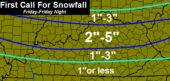
The next system rolls in from the northwest and works across the Tennessee Valley late Friday into Friday night. This will increase in intensity as it does so and that means it could become an overachiever. A swath of heavy snow is likely along and north of the track of this low. Here’s the first call for snowfall…
Pinpointing where that heaviest band will set up is the challenge. The zone could be a little farther north or south than I have it based on exactly where the low passes.
Another light snow maker dives in Saturday night and could put down some accumulations.
Next week will give us a false start to spring. Temps will soar into the 60s and we could have thunderstorms before the week is through. The following week into early March will likely see winter return with one last harsh period.
I will have the latest on tomorrow’s system on WKYT-TV starting at 4pm. I will also have another update later this evening.
Take care.

hello
Hello Rolo!
Got 6.5″ here in east TN overnight. Been a snowy winter in these parts, considering east TN doesn’t usually get that much in an average year.
You do an awesome job, Chris. Professional, thorough, and you usually get it right! 8 inches here in my neck of the woods in Hindman and still coming down!
Just washed my car, so siding with Barb this one. 🙂
“snow starved” Pulaski/Wayne still didn’t get any snow!
Looks like this system is on par with all the others for us….are we just not livin’ right in this area or what. 🙂
So true!! And frustrating! !! Would love to have enough to at least make footprints!!
It has literally snowed a complete circle around us all freaking winter. Its getting old……very old.
Us Wayne Countians can’t get a flake this winter! So over it and ready for spring now.
Hope today’s warmer temps don’t melt all the snow before the next one moves in tomorrow. Like the placement of CB’s now lines. Will move north a bit I am sure. May just get the last 300 lbs of salt off my truck this weekend. Would be nice to get it washed during our short warmup next week. Hopefully NWS sees what Chris has posted and puts out Adviory/Warnings for Southern IN/ Central Ky..
“SNOW LINES”
Thanks for the updates. Carter county can’t turn into Lexington tv if you have a satellite dish. we hear everything that happens in wva like we ever travel to those areas. They give same forecast as the weather channel. Rarely hear kentucky news so depend on you and website for info
YUCK AND DOUBLE YUCK…..:D
What is the rough estimate of timing for these snows tomorrow?
Late morning to afternoon and lasting until the evening or night. The more west, the earlier.
Same ole Same Ole for Pulaski, bring on Spring!
The first mention of “thunder ” of the season! Spring fever is starting to kick in. 😀
I’m starting to think Adair County isn’t going to get a big snow this winter. Hoping these snow totals shift to the south.
It’s unreal how every snow event for Wayne County, KY has been for an inch or less. Then it turns out to be less than less. Was really hoping for a last ditch effort from this next one but again, inch or less that I’m sure will turn out to be a sprinkling of white on the sidewalks. Winter of 13/14 has been a letdown for the lovers of big snows! Oh well, maybe next time! You do a great job Chris! I’ve followed your blog all season long! Next time I’m heading for the Deep South for a snowy winter!! LOL
Crazy to think the Deep South has had more snow than us in Wayne county, but that’s exactly the case! Ugh. Maybe next year. Bring on spring now.
Laurel County still “snow starved,” although the series of 1-2 inchers have been nice to wake up to several times this winter. I suppose the mention of thunderstorms next week may get everyone thinking about severe weather season around the corner…which means SPRING is coming! (Especially for southern Kentucky.) Thanks Chris for all you do… hoping for more talk about Spring and not about the possible last push of winter.(Maybe that will push north, as the trend has been 🙂 Have a great day everyone!
Well, if frankfort even gets the low end totals from this next snow we will be near 25 inches for the winter, not bad in my book!
You guys have done well up north after this AM i am about 7-8 inches for the season
Sounds better, you will top a foot plus before winter is over!
Feels pretty good outside right now. 34* at CVG at last check. Still below normal!
I have the feeling those snow lines are going to move north and totals will be bumped up. Would be par for this winter. 🙁
I am concerned warm air might cut into expected totals, but I always think that. Usually because it usually happens.
Bubba, depending on your surface temps when precip starts will be key. As usual there is alot of bust factor tomorrow temp wise, you really dont want temps to go any higher than the upper 30’s. Once precip falls temps will drop a good 5 degrees 38 degrees is a decent cutoff. If you go above the upper 30’s your chances of a decent accumulation of snow will go down big time. Bottom line will be how far surface temps rise tomorrow. If it starts off as all snow, snow will be falling incredibly hard at times very heavy wet snow.
You must watch Brian Goode’s video blogs all the time. He said exactly that.
Yes he did, a Brian Goode, is not that good, he said the Ice storm would be all rain?
I would have to disagree with you. He does a good job. He does miss some every once in a while. He and Kevin harmed may be two best in Louisville market
Belski was the best that station ever had!
One thing is for sure. The Charleston NWS will wait till it starts to issue any watches or warnings. Even though I can’t watch him on tv, I can follow Chris on here. Beats all of them, hands down in WV.
Looks like Somerset will miss out on the snow……yet again!!! No surprise there!
Same here in Nashville TN. These areas just can’t buy snow.
Yet there has been good snow in just about all directions around these places this winter, including to the south.
My parents near Chattanooga/Cleveland TN got about 7 inches this morning. Have not yet heard from my brother in Cleveland Georgia, but looks like they got roughly 7 inches there as well.
Same with Alabama. Look at Huntsville this morning (up to 6 inches depending on location), Eva (9 inches, Eva is just south of Huntsville/Decatur) and even as far south as Cullman (10 inches).
I’m actually a warm wx person (and I’m getting tired of the bitter cold), but even I’d like to see at least one nice…if brief…snow cover. Otherwise, bring on spring 😀 .
Big gap between the Haves and Have Nots this winter. As we know, cities like Louisville, Lexington, Cincinnati have had above average snowfall….in some cases way above average.
In contrast, Nashville is only 1.4 inches so far this season, well below normal. Memphis is even worse, only 0.3 inch. Yet again, big snows have happened further to the south. Go figure.
Bowling Green KY (where my wife’s parents are, I’m also a WKU grad) is a little better; they are up to 5.3 inches which is relatively close to their season to date average.
I’d like to see that 2-5 line park itself dead over Madison co. Then become a 5-8 line… that’d be just alright with me.
Thanks Chris, we have a total of 11-12″ where I live in Letcher Co. Me and my girls have accomplished our mission of making our snowman for the year. I am now ready for spring!!
50 degrees in London what little snow we got last night is already gone it’s strange when down the road about 10 miles 2 to 4 inches of snow.
Now you know how we felt in knox county when everyone else getting big snows and none here. hopefully your luck will change.
Please no more snow. Enough is enough. You people who want big snows must never have to get out in it.
Oh good grief.
Try moving it for a living. Do it every snow and I love it. If it is going to be below 32 degrees let it snow. If it is going to be above 32 degrees let it be 50 and sunny.
So are you saying you dislike the stuff that makes you money??
Actually every time it’s snowed this year my wife and I have made it to work in our regular FWD Sedans. We wake up and go 45 miles to opposite directions. Exercise caution, allow extra time, and you’ll be alright. No big deal.
Perhaps you need to research how to dress in cold weather?
I hike trails all winter. It’s beautiful, and serene because it keeps the other 99% home bundled in their blankets. As I discovered years ago, Berea hippies can’t take the cold. I also shovel snow for people in temps that they can’t handle as it doesn’t bother me.
we had a little over 2.5″ here is Southern Breathitt Co. Most of it has melted as it is currently 42 degrees here at my house. Roads are clear just wet.
For those of you that are upset of your lack of snowfall Kentucky Power reports nearly 5,000 without power in Eastern Ky. I like snow but I like a good warm house and electric a lot better than a few inches of snow that lasts only a few hours. I am sure our neighbors in Perry, Letcher, Leslie, Pike etc. would agree as well. I am very thankful we ONLY got a little over 2.5″
Rack.
Just because someone likes snow does not mean they like power outages. Silly post.
If anything, the people who want spring are the ones asking for power outages from KY severe weather. 😉
Up to 37 in frankfort, snowpack shrinking some in the direct sun but hanging on good in most areas, I think it’s waiting for reinforcements to arrive tomorrow 🙂
There seems to be a pattern here, with spring like weather taunting us the day before a snowstorm. The snow and ice are finally melting on my driveway in southern Jessamine County.
Whatever happens will happen, no complaints from me about a “bust” or “I told you so/trend is the word”, etc….. 😉
WOW, just read some info that says most of KY hits 70 next week, what a ride we have coming the next few weeks, should be fun!
Hit 40 here in Carrie of knott county with sun out
The snow is almost gone in Knox Co. The power of the sun. Four inch snow overnight almost gone 80 percent gone by 3:00. Oh well, can’t complain, because last night’s snow was an inch more than what we had the entire winter. Now it’s time for our friends on the border to my west to get a little snow. They have not saw much snow at all this winter. I’ve got my snow fix.
There is still some snow laying aroundnot sure where bobt is but this makes at least 10 inched more or less for the season in knox
Not sure where you live in Knox Co., but no where close to ten inches this year in the county seat of Barbourville. 7 inches tops here and about the same where Andy lives and he doesn’t live in the city. Any place that gets quite a bit of sun, the snow is almost gone now. I just looked out back, a place I measured 4 inches this morning and I’m seeing almost all green. Rooftops are completely bare. Of course places that don’t get sun, still have snow, but it’s been a rapid melt since noon today. Can’t deny that.
I live in barbourville. Not trying to argue but there has been at least two different snowfalls of 3″ each as well as a couple of 2″ ones,
http://mag.ncep.noaa.gov/Image.php?fhr=033&image=data%2Fnam%2F18%2Fnam_namer_033_850_temp_mslp_precip.gif&model=nam&area=namer¶m=850_temp_mslp_precip&group=Model+Guidance&imageSize=M
Somebody smarter than I am explain this to me. On the map at the link above I have always been under the impression that the blue line was the 32 degree line, which would make all of that dark green precip snow, right?
Big Papa, you are correct, however I believe models typically under estimate the warm air generated by clipper systems, especially stronger systems such as this one, more than likely warm air will be transported on the southern side of the system, which will undercut snowfall totals in the south..at least thats what I am thinking..I am not a trained met, just a typical weather geek lol…
Thanks, I thought I was going crazy there for a minute. It does look like though on the 18z run the line is further south than it was on the 12z run and the system is much stronger.
This is your freezing line at the surface
http://mag.ncep.noaa.gov/Image.php?image=data%2Fnam%2F18%2Fnam_namer_033_10m_wnd_precip.gif&model=nam&area=namer&storm=&cycle=18¶m=10m_wnd_precip&fhr=033&group=Model+Guidance&imageSize=M&scrollx=0&scrolly=0
Hoping for a good Valentine snow. We still have 5 good inches on the ground here in my part of Cecilia…Today’s temps are melting the icicles and some of the driveway. Which is a good thing.
Mid to upper 40s here with brilliant sunshine in Carrie, funny what difference a few hours makes
Temps near 40 in frankfort with bright sunshine, but the snow snow pack is hanging tough, still several inches everywhere but the sunniest spots!
I guess the NWS us out to lunch on this next event that is less than 24 hour away with no advisories! Sounds like they don’t trust the models again LOL 🙂
My bad the advisories have shown up now!
If you can believe the Nam it show’s a decent hit for much of the whole state..But it’s the Nam..What more are there to say..
The NAM has been pretty good on clipper systems this year. It and the GFS aren’t too far apart either I don’t think.
Hello everyone! It’s sunny here in the Gardenside area of Lexington and my heart is as bright as that sunshine today! 🙂 Sun, we have missed you! LOL! We are sitting at a positively balmy 40 degrees and I can actually see patches of the ground in our yard for the first time in what feels like forever! 🙂 I went to visit family in McCreary Co. yesterday and goodness, did I ever see what you all have talked about in regards to cutoff lines with the snow. Here we are, sick of our snow (just day before yesterday the garbage truck got stuck on the ice on our hill in front of our house – ugh, what a chaotic mess with them trying to get it out all the time missing the various cars parked on the street, etc etc. Sorry. I digress.) Anyways, it felt like I was traveling from Minnesota to Florida or something! LOL! The further south we drove, the more and more ground we saw, then absolutely, positively a big nothing. By the winter’s end, I hope that everyone gets in on some of the white stuff your way, without the loss of electric or frozen pipes, or wrecks on the ice, of course. Personally, I prefer the spring and summer months – I’m a huge flower and garden person – but even I feel that you can’t beat the beauty of a new fallen snow blanketing the earth around you. So pretty and peaceful.
When I talked with my mom today and told her that we still had plenty of snow in our yard in spite of the sun and warm temps, she reminded me of a saying I heard all my life “that snow is laying around waiting on another one”. And here we see that Chris is warning us of yet another storm, so she was right, it is “laying around waiting for another one”!! She is an old “country” woman and she and my daddy lived by a lot of the old country “signs” – the amount of fur on the animals, for instance, being thick on the cattle, meant a bad winter. The hornets building their nests up higher, also meant a bad winter. Things like that. Did anyone else grow up with sayings like that? If so, how many of them turned out correct?
If you have the time, I would love to hear about some of your “weather predicting” sayings! Of course we don’t have to worry about the cattle or the hornets to predict the weather for us as long as we have Chris and this awesome KWC site 🙂 But it’s still fun to hear all those wonderful traditions from the past.
Hope you all are having a great day!
Thx Strummer! Nice to see some other wx related topics on Chris’ site. I’m a city boy from Louisville and other than the wooly worm trick I’ve not seen anyone else post your info-love it, keep it comin’!
I think Monticello has some sort of magical forcefield that keeps snow away from here. We probably haven’t had over an inch all winter. And the time or two that it did snow, it came in the morning and was melted by evening. I absolutely lie snow, but I’ve given up all hopes of a good snow here. Come on springtime!
We (Rich. Va.) finally got a decent amount of snow. No work today; office closed! At home with my hubby, power still on, and lots of food (junk included). I even made some homemade hot chocolate. Round 2 starting up now. What a wonderful day! Thank you God!
LMK out with a WWA for Lexington and Louisville tomorrow. 2-4 inches. They seem particularly concerned about the evening rush hour.
and I think they are underestimating this clipper…
I expect some areas to end up in WSW by tomorrow.
This just feels like the one that is the big over-achiever.
http://wxcaster.com/gis-snow-overlays2.php3?STATIONID=LVX
that new NAM blows up over Kentucky once the low makes its turn east into southern parts of the state.
Wow…if that is true, the band of snow would be much wider than originally thought.
Thats what happened with the last overachieving clipper. Instead of a narrow 1″ band locally 2″, it turned into a widespread 1-3″ band more north than previously thought.
The warm air though. The last system like this was mainly snow for the north and mix rain for south. I can only go by what happened last time and treat the maps as opportunity.
Rain for southern ky, more snow in the mix from mckee/mid jackson co northward.
I would go 3-5″ for Louisville and Lexington. Northeast Kentucky 4-7″ if you believe the NAM that is. If it is still consistent later tonight I would have no problem with these totals.
actually, if you believe the NAM, the 18z is showing 5-8″ for Louisville/ Lex. 🙂
You have to subtract an inch or two at least from the NAM. Notorious for overdoing snow amounts.
So instead of an ankle biter, an arch tickler. Same amount of salt, regardless.
wow! a Valentine’s snow- that would be really cool….
my wife and I were talking about that the other night…seems like we’ve had a few Valentine’s snows over the years.
really happy for all the folks in EKY that got a good SNOW!
I don’t live in Ky , but I have been reading your blog for several years now. I live in Va on the Pike county border and have to say you get my weather right all the time. I don’t even bother with my news stations anymore I just come here. You have had us right this whole winter and sometimes im afraid to look what your forecast is….since I hate snow….lol. You had us at 6-12 for this storm and we got the 12. Thanks for all you do for us even the ones that hate snow……
Well locals and the NWS louisville has Hardin county in the rain/1 inch snow category. Chris has us on the border of the 1-3 and 2-5 inch snow. Guess we will find out soon enough. Ooooo how exciting! 🙂 lol
😉
what is the timing of this snow tomorrow for us in Far North East KY, will it be before we get out of school? We were out today due to getting a BIG surprise this morn, thought we would get abt an inch and we got 3 inches of snow!!!!
Chris south shore ky is not getting any more snow
Hopefully Louisville will get hit good tomorrow. Might be the last decent snow we get this winter. I have been satisfied with the winter but still would’ve liked to have seen a good foot of snow but I can’t complain.
Been out riding ATVs in the mountains of NE Pike County for several hours today with some friends. We measured the snow a couple of times along the trails and the snow measured in between 9-13 inches at different locations. Today was a beautiful day in the EKY mountains, and was a great day to take out the ATVs. Hopefully the rest of the state can get in on the fun with this next system…we have our fair share and hopefully mother nature will spread the wealth.
I love snow too………….But I don’t want anymore……..(LOL)
Another three to five inches in Lexington? Chris…….This time I really HOPE you’re wrong…..At least next week will be warm
I washed my car, so also agree. The power of Barb compels thee! Ankle biters begone!
Yoy guys love snow, you can’t fool Mother Nature!
🙂
Clouds have moved in east frankfort, if these hang out all night and keep temps up, rain may come into play tommorrow and cut snow totals down!
My folks in Chattanooga/Cleveland TN had about seven inches snow this morning, but it’s already mostly melted except for areas hidden from the sun!
Winter Weather Advisory now out for central KY, Louisville and Lexington included. Basically along I-64 and extending north.
Whoops, I see now that CB has a new post about the WWA.
Well
I just love the snow,its beautiful ,and makes the little ones so happy to play in it and build snow men,I love doing that also…lol .it don’t bother me either way we have to accept what the good Lord puts upon us.Have a happy valentines day.