Good evening, gang. A band of very heavy snow is likely to sweep across the bluegrass state on Valentine’s Day. This can lay a smackdown snow on some areas, but pinpointing where that is continues to be the issue. Odds favor this being along the Interstate 64 corridor.
My latest forecast remains unchanged…
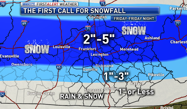
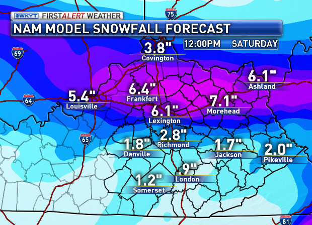
My concern will be for a narrow band of even heavier snowfall showing up somewhere along the way. Similar systems from years past have featured something like that and the NAM has been trying to hone in on that…
We will see how that goes as we get closer. A WINTER WEATHER ADVISORY is already out for parts of the region…
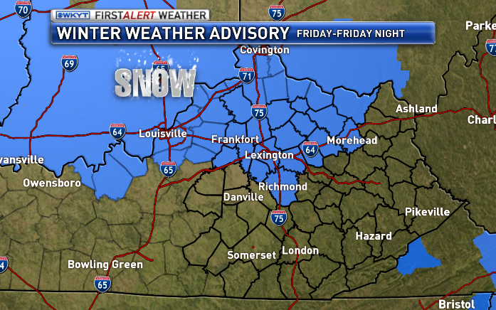
I would think many more counties get added to that before all is said and done.
I will update things later tonight and on WKYT-TV at 11. See ya then.
Take care.

Frankfort looks good on that map, Thanks Chris!
Thanks Chris. My thoughts are being on Spring! I have lived as vicariously as I can through pictures of snow elsewhere. Now I’m dreaming of short sleeve shirts, flip flops and my sunroof open!
you da’ man, Chris!
we appreciate your hard work and skills.
hope we get in the heavy band but it’s all good for this SNOW lover.
Speaking of retro, still no big snow retro love for Richmond and Berea, and places around it. Being spiteful here and hoping for a salt free bust, rather than a another salt crusting mini snow.
TPOBCT!
is there an estimate on when this will get going in the Lexington area? I have finally saved enough pennies to go get my hair did tomorrow night. I hate to cancel if this is going to end up being an overnight snow.
and Chris, two simple words. thank you.
what is the timing of this snow.
It is supposed to start around noon here in Lexington and the road conditions should deteriate as the day and evening progresses.
This weather has been bad. But its still not in the league of 1978.
Drove by the Ohio River today.
river water is still flowing.
Something I find odd. The NWS Asheville issued a winter weather advisory for much of their area affected by snow tonight (not for an actual weather system, but for black ice from refreezing)…..That’s ODD…..I mean, the actual system is over. I guess different regions have different methods? I dunno….I don’t ever remember a winter weather advisory being issued here AFTER the fact, but just a special weather statement or something.
The NWS in Louisville goes by a criteria, but, for example, the NWS in Paducah issues winter weather headlines by impact. Meaning if a quarter of an inch could fall but 100% accumulate on the roads, then a WWA could be issued. But if a couple inches fall and it’s above freezing, then they might not issue one if they don’t think impact will be enough.
I want to say the NWS in Louisville does this as well, but they tend to be a bit reactive instead of proactive. Better to be reactive I say than do nothing.
Like others are asking, what looks to be the timing of this event? During the day, afternoon, or evening?
Temps holding at 35 in frankfort, clouds are keeping temps up, crazy how it was sunny all day and clouds hit at dark?
Temps are forecast for mid 20s for lows, this might be be something to watch if we stay warmer tonight! Could hurt snow chances!
When if ever will a snow not have that middle of the state cut-off? It is that or a diagonal version of it with the pivot point almost always north Madison. The Lexington Richmond difference of 3″ says it all. They are 15 miles apart.
The power of Barb compels thee!
And of course the usual I64 location as option two, which has been very common over the years. I guess why that is option two.
Bubba, I live in Lexington but work in Richmond, the Kentucky river IS the deciding factor. I still have four inches of snow on the ground, where as Richmond is all most snow less on the ground. The last major ice storm Lexington was shut down and after crossing the river, Richmond had almost nothing. A few years later, Richmond got blasted with Ice and Lexington received nothing.
It had a good and bad side 🙂 🙁
Good luck getting someone to admit to the small distance but often large difference in outcomes versus forecast.
Bet on north, east and west and even south s-east, but not mid to south central. Uncanny.
Coffeaddy, I hope you folks in Somerset can pull at least 3″ out of this one. you deserve it and you’re overdue. 🙂
Somerset probably won’t see a single flake…just like all season. I’m just sick of this snow-less winter.
Doubt we see anything down here(Monticello) We’ve not had any snow to speak of this year. Very disappointing and has me more than ready for spring. 🙁
Just saw TG shuck reporting for the weather channel live, now that he lives in New York City I guess, we still love Chris but no hard feelings TG 🙂
Isn’t that where they make the terrible salsa?
Get a rope!
I was expecting the Madison County cut off. If the pattern holds – Lexington, Fankfort, Harrodsburg, Lawrenceburg will get 5 to 8 inches and Richmond / Madison County will get perhaps 2.
As bad as we have it is seems south central KY has had it even less. The historical patterns are freaky weird….
Fence science.
Its a thing.
im 39 years old and I remember SEVERAL WINTERS being ALOT worse than this year. back in the 80s..
Everyone thinks Rolo is the old man of the Blog, I’m 50, your just a spring chicken LOL 🙂
I’ve always thought he was too!
That is dang old in goat years 🙂
Would love to know what Chris thinks of the clouds and south west winds tonight, this next storm has bust written all over it if the warm wins out??
Well its kind of a double edged sword. True while clouds may prevent temps from cooling tonight they will also prevent temps from rising much tomorrow.
Just walked outside to check cloud cover and they have moved out for now, temps starting to drop, 33 now in east frankfort!
Probably bubba clouds. Where they shaped like Darth Vader’s helmet by chance?
Bubba always has a clouded outlook on his weather 🙂
🙂
And they are moving at ludicrous speed! As commanded by Darth Helmet of Spaceballs lore.
Eastern Ky will sit on the sideline’s and wish everyone a good snow..Still have 5 inches on the ground even from today’s warm up…Hope you enjoy…
East Ky Broadcasting, radio, is forecasting 45 degrees tomorrow and rain. Rain and snow mix tomorrow night. Something is wrong here.
Just once I wish Warren Co would get something other than just a dusting!
Rapid melt in the sunny spots today in Knox. Places that didn’t get all day sun still holding on to some snow. I’m okay with that. This time of year if I get snow I would just as soon it not lay a long time. Good luck to you guys in the higher snow range tomorrow. I know some of you have enough snow and want to move on to spring. Wish you could send it down to the Somerset area. I got my fix last night in Knox.
i want to take this time just to thank chris bailey for his countless hours of work that he does not get paid for such as doing this blog…..this has been 1 wicked winter, 1 of which we have not experienced since the early to mid 90’s and sad to say we are not through yet with a month or more to go and he has used his forecasting expertise to keep us informed for all the harsh winter weather we have experienced this winter……he has readers not only in kentucky but in wva, ohio, tenn. just to name a few states…….i am reading and following from wayne, wva just about 20 miles south of huntington, wva……i have done so since his days with wsaz channel 3 in huntington, wva……keep up the great work and you are second to no one in the business….imo…..god bless.
I second that..As someone mention earlier i think Chris deserves a raise and a bonus..Come on WKYT fork it over..
I third it lol.
I second that, toney! I’m in Nashville TN, but despite liking severel of the local tv mets, it’s hard to beat CB!
A reminder for those outside the Lexington tv market. You can still watch Chris via wkyt.com .
PS: toney, you may be only too aware that the same West Liberty KY tornado two years ago later plowed into Wayne County WV near you, an overall path length of nearly 90 miles. Glad that there were no lives lost in WV that grim day.
To show what a wx nerd I can be, I can watch Chris at night via internet live feed. Then only two minutes or so after CB is finished, I can watch WTVF Nashville tv met Ron Howes! Can it get any better than this?!! 😛
Yep, it is what it is and that is the way it is, but this is about as surprising as mint juleps at the Kentucky Derby. From CB’s new tweet:
“There will be one heck of a heavy snow band setting up across the Interstate 64 corridor tomorrow afternoon/evening.”
Why not more of the state like other states? Uncanny- the horizontal or diagonal Kentucky fence. It works out either way, regardless of system type. Other than our most southern of states, our state is the only one with such a split for snow. Not an exaggeration.
Easy to explain 😉
en.wikipedia.org/wiki/Ley_line
LD – That’s interesting.
everyone else in Louisville is calling for more snow totals but WLKY just announced less totals now and storm coming in warmer? confusing
Bailey for president!
Always a bridesmaid…never a bride in London.
going be to warm to see HIGH TOTALS tomm afternoon. sorry but 1-3 tops for anybody.
CB already stated the main action is likely the I64 area. Seems the higher side of the map is more likely there and the opposite the further south you are.
That would be known as the fence.
yea don’t hold ur breathe on a raise for CB..LOL there to tight for that. that said BAILEY salary is healthy already for a Lexington WXMAN..
It is called budget displacement. CB gets a raise and a paid intern is shown the door. CB would not diss an intern. They get the coffee 🙂
The weathermen need to quit including Richmond in the snow forecasts.Whether it is coming from the North or the South,it just never gets here. Maybe an inch but that is about it.
starting to see some flakes here in athens oh temp went from near 40 to 36