Good afternoon, gang. We are now in Winter Storm ALERT mode for the northern half of the state. This is the area that is targeted for the heaviest snowfall through Saturday morning. Areas across the south will fight the initial surge of mix and rain before going over to snow later this evening.
A WINTER STORM WARNING is now out for much of northern Kentucky with a WINTER WEATHER ADVISORY out for areas south of that. Here’s a look…

An area of low pressure will strengthen as it works across the Tennessee border. This will be a very energetic system that will cause a band of heavy snow to break out just north of the track. That band continues to target the Interstate 64 corridor and points north. The prime time for snow will be between 4pm and 2am.
As the low goes by… my concern is for a rapid switch to heavy snow that wraps in behind the storm. If that does happen… higher snow amounts will be realized across the board. That will be something to track on an hour by hour basis. Here’s the final call…
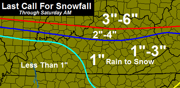
Again… watch the wraparound snow with that low! The bust potential could end up being on the low side for some areas.
Another light snow maker will dive in Saturday evening and night and that will provide us with light accumulations.
I will have the latest on WKYT-TV with live updates throughout the afternoon and evening and starting at 4pm.
Let’s track…

I-75 @ Winchester Road Lexington

I-75 @ Iron Works Pike Lexington

I-75 @ Clays Ferry Bridge South Between Lexington and Richmond

US 60 @ US 127 Frankfort

US 127 @ Frankfort Frankfort

I-75 at MP 36 London

I-71/I-75 at Buttermilk Pike Near Covington

I-64 @ 3rd St. Exit Louisville

Downtown Louisville @ 2nd & Broadway Louisville

I-65 @ 234 Near Bowling Green

Take care.

Thanks Chris. Hope your headache is better.
The fam & I will be at KBA all weekend, LET IT SNOW…
Dodger sad! Looking like a slightly too warm bust in my area. Dodger ready for spring … missed too many this season. 🙁 Dodger!
Looks at the bright side the dodgers will be playing baseball soon 😉
Ironically, this Dodger is a Cardinals fan! Dodger’s blood runs red! Dodger
^Dodger is despicable
There is something wrong with people that always speak of them self in third person.:>{}
LOL at NWS
Why are you laughing at the NWS? The Louisville office has been great this winter season.
Jackson has been also.
Not to take issue with you, but Jackson has been terrible with Wayne County. Going from 1-3 inches this morning to less than an inch in this afternoon’s forecast. last month we were one of two counties not in a wwa, then the next forecast we were upgraded…then by the time the event came we couldn’t make footprints in the snow. I like Jackson in Spring, Summer & Fall, but their winter 4casts are inconsistent in a big way at least in my part of the world. That’s just one man’s opinion that and $3.40 will buy you a tank of gas.
Same here for the snow we just got they said less than inch we got 4-5
NWS Jackson=incompetence
I guess it all depends on where we are. In my yard, Chris has missed most every forecast this season. And I wish I could get a tank of gas for $3.40, maybe for a push mower 😉
Yippee…
Hope you are feeling better, Chris!
Crazy that the sun is out in frankfort but stuff is showing up on radar over us??
Antecedent moisture on radar returns. All that is very high-level moisture which is obviously not making it to the ground. If it’s showing up on radar and there’s sunshine outside it makes me wonder if ice crystals are already starting to form there. *scratches chin* Not implying anything, just making an observation..
Look on the bright side–whatever you get–if it is a trace or 6 inches, it will be gone by next Friday.
How is that the bright side? I want the ground to be snow covered until openning day of Keeneland.
I like this plan!
48 here in knott county gonna crack 50
No sun here in Gtown. All gone and replaced by this thick gray cloudy sky.
Nice verga storm happening now!!!
Not seeing the wrap-around snow that Chris spoke about, the radar trend looks to be sending the best moisture do east thru Indiana and Ohio, I guess northern KY will be the bulls eye again, those folks will be approaching 50 inches if this storm verifies for them!
The low is going to intensify later today and into the evening. That is when the heavier snow bands will develop. Can’t go by what the radar is showing now, this thing is going to pop right over us.
Hope your right, would hate to see this one underachieve after looking so promising!
Louisville right on line. Think will be interesting but worried just little too warm
The warm air has me wondering also, here in frankfort it’s 40?
Per Chris’s tweet, we should just call interstate 64 the Bubba Expressway.
I like it.
15z RAP still shows heaviest snow just north of Louisville. The Metro itself still looking at 1-2″; however, Friday rush hour could be impacted if snow falls heavy enough.
could be local high water issues S CENTRAL/SE KY
Like I said earlier it comes down to surface temps right now surface temps are going to bust the snow totals watch and see. Northern Ky southern Indiana and Ohio will get a nice thumping but im not all convinced the I-64 corridor will see anymore than a sloppy inch maybe two. Louisville sitting at 39 degrees even with evaporational cooling it will be hard pressed to get down to 32. It will get well below freezing but looks like that will happen after the real good moisture has left. Unless there is some crazy dynamic cooling that is going to take place im sticking to my guns on this one.
I agree, I’ll bet the 2-4 inch line is pushed further north of I-64, warm is winning in central KY, heck the sun still out in frankfort with temps in the low 40s, 1-2 inch might be a stretch!
I’m not giving in on this one, Prelude, lol…
Although, good call on temps. I figured 37 tops. It is now 39.
Have to stick with my 4″ prediction though, or I would look like a MET (haha).
Come on, a little weather humor.
If the low wraps up enough like Chris says this could SURPRIZE us with heavier snow??
Another storm where one area gets few inches and 15 miles away may have 3 times as much. There has been so many of those this year
Thunderstorm or sleet on radar in western KY?
Dodger sorry to report BIG underachiever in west KY so far! 🙁 Rain and temps in upper 30s! Once again, too warm!
WHHHHYYYY can’t Wayne/Pulaski get any snow?
Because the new Florida is Southern KY I feel your frustrations.
We are currently sitting at 43 at my house. I don’t see us getting very much snow unless the temperatures drops dramatically.
Because I have nothing better to do on this so far snowless snow day and because we really need one, I present the Kentucky Weather Center Lexicon…all in good fun and feel free to add to the list…
32 Degree Rule- Temps at 32 and below equals dry air wins. Temps at 33 degrees and above equals a moist atmosphere.
Andy Rose- Lives in perhaps the unluckiest place on Earth when it comes to snowfall. When it does snow, it melts within 24 hours while Central and Northern Kentucky keep their snow pack for 14 days.
Chris Bailey- Head Weather Weenie (See Weather Weenie).
Chris Mercer- King of the Weather Trivia.
Coffelady- Perhaps the nicest person on the internet. Makes everyone smile on a cold and rainy day.
Darth Bubba- Perhaps the most entertaining commenter at KWC. Is the gatekeeper of Fencetucky (See Fencetucky below). Rumor has it he has a steep driveway which isn’t fun to shovel. Appears to have had more salt accumulation than snow accumulation.
Drought- A common visitor to Kentucky during the late summer months. Is especially fond of showing up at the homes of Todd and KellyinLouisville, even during abnormally wet years.
Dry Air- Something we never have in summer but an abundance of in winter. This is especially so during snow events. (See Virga).
Euro- European weather model that has been the most reliable over the past several years. Famous for nailing the track of Hurricane Sandy a week out when all other models were out to lunch.
GFS- American weather model that is notoriously awful during winter. In a cruel twist, is quite accurate when it comes to predicting ice storms. Is the Holy Grail to the National Weather Service.
Ice Storms- The bane of all residents of Kentucky. Just the mention of the word freezing rain brings shivers to every KWC commenter.
Model Mayhem- The common conflicting weather forecasts from the various weather models. When in doubt, ignore the GFS and NAM and go with a blend of the Canadian and Euro.
National Weather Service Jackson- Always late to the game when it comes to winter advisories. Worships the GFS.
National Weather Service Louisville- Perhaps the most conservative weather office in the country. Continues to worship the GFS and despite incredible controversy and the wrath of both Chris Bailey and John Belski, insists that the official thermometers at both Louisville and Lexington are accurate.
Rain to Snow Event- Forecast calls for precipitation beginning as rain before changing to snow. Forecast typically calls for 1-3 inches of snow. In reality, the changeover never happens and the moisture is gone before the cold air catches up.
Rodger in Dodger- Refers to self in the third person. Dodger!
Rolocoaster- The official forecast of one Rolo of Clay County. Known to go from Old Skool to just rain and back again in the span of just 4 minutes. Does not believe in spell check.
Salt- Used to melt snow and ice on area roads. The snow to salt ratio in Kentucky is generally on the 1 to 3 range. For every inch of snow, 3 inches of salt will be used.
Snowdome- The invisible but very effective dome that typically covers the entire state of Kentucky during the winter months. For some reason, the dome has shifted south this winter as Central and Northern Kentucky have done quite well on snow. Northern edge of the dome is believed to be along the Kentucky River in Richmond. Darth Bubba is just inside the dome but can can see snow on the other side. The strongest part of the dome is believed to be over the home of one Andy Rose.
Torch- The official temperature forecast for January 2014 from Bryant. The month ended up being one of the coldest in decades.
Virga- The common radar event in which radar returns show heavy precipitation (especially snow) falling over a particular area when in reality, nothing is falling. Never occurs when the temperature is above 33 degrees.
Weather Weenies- The readers of Kentucky Weather Center.
Everyone in the southern half of Madison county officially changed our astrological sign to Virga or WarmAries many winters ago.
Great read, you forgot dry slots, which form mainly during ky snowstorms 🙂
🙂
Probably the greatest, insightful post in the history of this blog… I have no retort.
Nope, it is probably one of the greatest most insightful posts of any blog.
Lol.
one of the best post ever on this site.
Wow, that took a lot of work to put all that together! Fun reading!
That rocks……
Bravo!!!!
Probably one of the best posts ever on the blog!!! Made me laugh out loud, multiple times.
maybe this post can go on the sidebar, we can refer newbies to it for reference.
If Bailey has a glossary plug-in for this site we should start with this and could add to it over time. Brilliant!!
Your lexicon needs it’s own page. Required reading for newbies.
Excellent read! I’ve been a fan of this blog for about 3 years now and although I don’t know many of you or comment very often, I’ve gotten a feel for your personality or weather situation from your comments. You wrote a very accurate reflection of their personalities and the weather anomalies that occur in KY.
That was awesome! Good job
Wow! I cracked up like heck! Lol, It’s true, this is not one of, but THE BEST comment I have seen in this blog! We should refer this comment to CB to have it on the side bar like Jen said, that’d be so funny.
Brilliant!!
Great post, Kim!
You, too, Kelly! 😉
Definitely, by far, the most entertaining post I have ever read on this site! I will think of this off and on all night and start laughing out of no where like a loony person!
Add mine to the list of praise. So funny and true!
Now casting here….Verga on radar nothing hitting ground or falling that I can see. Only looks ot be a couple hours of precip for Louisville. We will be lucky to get an inch out of this. Bust here in the metro…..looks like Southern, IN / Northern Ky will be the true winners once again.
Have to agree, any rain (and looks like there definitely will be) will cut down totals quite a bit, and this system looks to scoot by very quickly. Hoping the heavy precip developing on the leading edge right now can cool us down a little quicker, but doesn’t look great at this point.
I wonder if much of this storm will become virga in central kentucky as the sun is shining strongly. Rather have virga than rain!
Sticking with the original thoughts. In relation to the map, I64 and north are likely to see the higher ranges for their area. Start dropping to the lower range, especially south of Lexington on down.
The wraparound is intriguing though, but CB is very aware for some bust potential, south of 64. Hence the word is in his post. CB is both a good met dude and skilled in the fine art of posts 🙂
Honestly radar does not look impressive at all. Seems to be trending even further north than most models predicted.
Yes, but the kids of Fayette county and others would like to thank their leaders for the extra time off school today 😉
You can thank the chaos of kids in Alabama and Georgia from last week for today. Winning!
True. 🙂
It is a well known fact here in central kentucky that early school dismissals have meteorological effects on our weather. The hot, dry air emanating from certain members of the fayette county school board severely limits snowfall potential.
Strange science fact, but true 🙂
For those of you wanting an end to the snow…
i.imgur.com/kDQ0SgK.jpg
Here in Louisviie we have invisible snow falling from the sky.
Bust for Louisville. Starting to think that more and more. So frustrating.
Getting reports now of heavy wet snow in Battlerock and Brandenburg KY.
If it is snowing in those spots that’s a good thing. Both are south of the river and of I-64.
The radar shows both those areas as heavy rain. Hang in there.
41 degrees in Jtown. Storm looks like it has shifted way north. I think if we get an inch here we will be lucky!
Usually you can spot the wraparound stuff CB is talking about but not this time. What gives?
To be honest, I do not feel confident about the 2-5 inches for Lex. I was outside waiting for my kids in shorts and not even cold whatsoever. It is way too warm outside right now for an accumulation like that. I say a less than inch for us here for sure.
starting to snow here in athens
temp is still 36 37 but getting a litte windy
Big Fluffy snowflakes in Corydon IN
Starting to rain in the metro near Iroquois Park. Its actually coming down pretty good now and I can see a flake if I don’t blink.
12z WPC still has I-64 and areas south/north of there under the moderate risk for 4″+. It has the same area in the slight risk for 6″+.
I guess I’m on an island with CB, on this one?
Don’t worry I’m on the island too.
Yes, but CB built in an escape dinghy to float to safety. The material for the dinghy are a wide snow range map and the seeded word, “bust”. 😉
I told ya since yesterday that the surface temps would bust this forecast
I still think it won’t be a bust 🙂
If you listened to Chris, the NWS forecast discussion, or watched the models you would know that the storm is behaving as predicted. It is suppose to moving in and then intensify right on top of is. Don’t worry, the snow will come later this evening so please stop crying and whining. If it doesn’t happen you can, but please wait till the storm has a chance to do what is predicted.
Please do not post reason 😉 The drama is what keeps the blog alive 🙂
Bwahaha! Good lord you made me spit my orange spice tea right there.I am definitely a Bubba fan. 🙂
Kind of true though 😉
That’s what made it so funny. 🙂
Thank you.
Moisture falling from the sky now in Louisville
in the form of rain sleet and snow.
I will glady eat crow on here if I’m wrong.
But, I’m am still in camp Bailey. Just as I post this, I see this storm growing on the radar…oh, wait a minute. What’s that in Illinois starting to for as well? I think that is the wrap around starting to build that CB talked about.
Have faith snow lovers. After all, it’s heart day.
For=form
Was about to post the same thing regarding the wrap around band. Just now switched from mostly rain in J’town to a healthy mix of big flakes and rain as well. Storm does look nice on radar, and NWS said the low should slow a bit as it interacts with the trough. Chris is usually pretty dead on so I’m hoping that when it does go to all snow we make up for the rain with the snowfall rate.
picking up now here in athens ohio temp slowly falling and they bumped up the snow totals
47 in lewis county right now.
The weather channel just posted a pic and it’s got lex in the rain mix
notice sum giving possible excuses out there now as far as LOWER totals than they have had. u can talk bout wraparound all u want but once it keeps moving east that’s it. rain will control 80 percent of tonites system. I stick to my 1-3 from north of scott co. sorry.
Wraparound or no wraparound, that radar has grown and slowed down.
FYI: snowing big flakes in NE Louisville and along I-64 in Louisville.
Temp was 40.7 an hour ago. It has dropped to 37.4 in last 20 minutes.
Snowing now in Shelbyville, too.
I love it when CB holds his ground and wins out.
I know it is late for model watching but 18z NAM still shows this thing really ramping up right over central KY.
The minority may just win this one.
If anything, at least CB doesn’t change his forecast 4 times in 15 hours like some.
I won’t name any names. But, they are out there in TV land lol.
I know MM on 32 had mostly rain to snow many days ago for this event. He didn’t fall for the banana in the tailpipe.
I never changed mine either i stuck to my guns. I said surface temps would be key
True, but the short term models like the High Resolution Rapid Refresh are fairly accurate. It shows hour by hour runs out to 18 hours.
Models have been awful with surface temps. The reason why I felt like this would be a primarily rain sloppy mix yesterday was temps got into the lower 40’s yesterday, last night temps did not fall as low as mets were thinking and something told me that temps had to get into the lower to mid 20’s this morning for this to be a dominant 2-4 inch snow event. Main concern this morning was the filter sunshine and that was able to get temps to around 41 before precip hit. I said earlier this morning temps would hit between 40-42. This late in the winter season the sun angle gets stronger. I had my doubts last night if the strong cloud deck would get here before sunrise.
Mike S whats it doing in Valley Station? I see some yellows showing up on radar in your neck of the woods
54 here in Carrie of knott co
Wsw now here in greenup
I think southern Madison County ends up with the Dolly Parton snow forecast today…a big bust, like Chris says.
Ruh roh! I think you have unwittingly created a new term for a weather bust. And by that standard, south of Lexington is one big Dollywood! Dollywood gets snow though, but that is not important right now 🙂
Kelly in Louisville, best post ever…a MUST for the blog side bar…I have read this blog for years, never comment, like you, I feel I know the ones that do comment, you nailed it…great job, thanks for the laugh.
Radar looks decent but nothing falling in east frankfort at the moment!
Roger says we all need to wake up to the FACT that models go too far south with storms. Geez! Dodger
Why do I wonder that Roger’s favorite “food groups” are biscuits, mustard and fried taters? 🙂
picking up now temp has dropped like a rock down to 33 now
Rain/Snow mix falling here. At times it looks like it’s trying to go to all snow and other times it looks like all rain.
Look at that sweet rain coming for Lexington. Wash away the snow and bring on spring… Bailey knew what he was doing with “bust potential”
If needed, the dinghy is ready to set sail!
you are rolling today Bubba! Must be excited about a long weekend! lol
No snow is no fun, so might as well have it other ways 🙂
Every forecast for Berea has a high bust potential, be it snow or rain. Our dome is strong.
Just started a fine snow in the big city Of Owenton. Here we go again NKY
Looks like we have gone to all rain in Shelbyville.
It is literally all rain south of I-64 and all snow north of it.
I am at work in Shelbyville and the rain is winning out with a temp of 39. At my house in NE Lou, the temp is 35 and nothing but snow.
34.5°………heavy snow in Worthington Hills. Starting to stick.
I am so glad I live near I-71 and not I-64
Down to 33.8° NE Lou.
It’s been snowing in my area of Louisville, the northeastern section, for about an hour now. The temperature is still 35-36 degrees so nothing is sticking and the back end of the precipitation is not too far away. It just got too warm ahead of the storm for much to happen.
Winter storm warning now out for area of WV. We had 5 inches this morning. At 3 there is nothing but the shoved piles left. Temps near 50 and the sun shining brightly.Predicted high today was 37. I am hopeful of more snow. But this had bust written all over it.
With all that rain and the big donut hole I see on the radar, it could be a snow bust for Central KY, and with that, and baseball spring training starting up, I am now in full-blown Spring mode
Raining in frankfort, Chris still calling for 2-4 inches here, so no reason to panic!
Rain is winning in Hikes Point.
Well Winter has returned Back to normal.
For example Hoping that a low Backside Will over perform
The temperature is dropping. Down to 37 but still light rain falling; no snow or sleet. The air above is at or below freezing. It will still take a little more time for this to affect surface. After sunset, look out. Transition to all snow will begin affecting pavement, especially heavier bursts.
Mike, it depends on what part of the city you are at. Out area has transitioned to all snow for almost an hour now.
Right. I live in the southwest part of the county where it’s all rain, not even a hint of snow yet. But colder air is working in from north to south.
All rain here in Jtown. Close to 265 and a few miles south of 64.
The majority of that would had Melted.
At least Mother Nature Is washing Our vehicles For free.
In southern jefferson county and been all rain. Would have probably had 1.5″ by now. 15 miles and all the difference
Westport Road off 265 has been all snow.
Like I said…I-64 is truly the cutoff.
The story of the winter
I know… move to Shelbyville Rd and points north, lol
I wish. I’m a mile North of 64 in Frankfort, all RAIN so far.
I’ve had 0.09″ rain. With a wet snow consistency, we would have over an inch of snow by now.
Down to 37 in frankfort, temps are falling but not rapidly, light rain still falling!
925mb reading at freezing literally across the Ohio River from Louisville. 850 mb reading is at least -2 degrees Celsius. That’s why snow has mixed in with the rain.
Temperature in my area of Lexington is sitting at a steady 42 degrees and has been since I got home from work at noon (after they called off schools and canceled our pm preschool sessions). I think this has been a blessedly snowy winter, but I just don’t see this one…
Mix just started falling in downtown Lexington.
This storm better really get cranking or even southern indiana want get much. It looks like moisture is not to far west of Louisville. I thought this thing was suppose to intensify
Well I guess all that road pre-treatment Lexington put down is going down the drain.
Rain snow line about 15 miles north of frankfort, just heard from a friend driving north toward Owen Co. And it’s snowing heavy at the Owen Franklin co line! He said temp was 33 their!
Jefferson County in Louisville expecting from 1 to over 4″. Quite a diversity.
Temperature at 36 in Valley Station. Still all rain.
I believe once the temperature cools to 35, we’ll see snow mixing in here. Basically, within an hour we should start transitioning. But, snow won’t be sticking very much until after sundown.
Still in 50s and sunny here in knott co
Cold rain, cold rain, cold rain…if that. Actually, at 47 degrees here, it’ll be a warm rain, warm rain, warm rain.
It has been all rain in St. Matthews in Louisville. Oh Mr. Bust, how I love thee.
All rain on the west side of town too. Looks like some flakes trying to get busy. Buster!!!
The snow line in Louisville has been funky.
The all snow area is from Hurstbourne Pkwy east and north of Shelbyville Rd.
If you are on Westport Rd/ brownsboro/ Pewee Valley, you are sitting pretty. Goshen, Prospect, Springhurst, Worthington Hills, Forest Spring, Anchorage, areas all snow. The rest of Louisville RAIN!
Can’t complain though. Had a lot of snow in my area. I’ll give winter a C. Would be a B+ but too cold.
Haha…I’m ok with the cold.
I give it a B+.
It’s a bust for Louisville. All rain here. Maybe a lucky few in the east end will see 1-2”.
Points north of river to see nice snow. Northwest shift!!, ha ha
CB might be getting provisions ready for the Dinghy. For a three hour tour, a three hour tour.
Looks like the first round Here in L
ouisville will end in rain.
Raindrops beginning to mix with snow in Valley Station. Temp at 35-36 still.
We probably wont get much snow here.Its still 50 degrees but the wind is really picking up the last hour or so.Should be raining soon.
Channel 12 Louisville just said less than 1 inch from Louisville thru frankfort area???
Never heard of channel 12 Louisville.
WLVK, what’s Jay say and Belski!
Even dark green areas are virga for Berea thus far going by Accusuck Radar. Do they need more hamsters to run that thing?
Just upgraded from a WWA to Winter Storm Warning here in Culloden, WV. Earlier the NWS forecast was for 2″ to 4″ and they just upped amounts to 4″ and 6″. Looks like they agree with Chris for the River Cities in West Virginia.
Sorry but here in Fayette County this is looking like a Dolly Parton. Thank goodness my son got home from the bus stop before it started raining! ; )
Temp down to 35 in frankfort and still raining, must not be as cold aloft as they thought earlier, should be atleast some mix at that temp??
anybody that fell for this snow is a non weather follower. just sayin RAY CHARLES could saw this..
You’re annoying
once again ill say HIGH WA.TER is going be worse than any snow
In Kentucky we should name our storms that bust since not enough actual winter storms to name
Valentine Heartbreaker
Until we have an actual major winter storm, all of them might as well be called No Show Jones as far as I’m concerned.
Well here in Louisville We really cannot complain very few snow bust this year.
Actually I’m looking forward to the warm week ahead.
Is Tennessee stealing our moisture, looks heavy down that way, much lighter returns around central KY??
Unless it resembles roadkill on the satellite feed, I think we’re safe from them consuming our moisture.
4 to 5 inches of snow still on the ground here with rain coming, could we see some flooding?
not in central KY so…
Really? I’ve still got a cold Kentucky rain coming down with temps in the mid 30’s and a snowpack on the ground. I also live in Central KY!
Mercer, I swear I will buy you a Snow Pack charm for your Pandora bracelet, if you’ll stop reminding about having a snow pack. 😉
LD: Don’t worry–it will be gone soon. Maybe even tonight!
Total bust in West KY. Too much warm air and snow stayed north of I-64!! Even systems coming in from the northwest bring too much warm air to our area. 🙁 I’m done with missing every freagin’ system. Bring on spring!
You are in Henderson and have had snow on the ground how many days now? Tired of missing every system? Had a good snow followed up by ice which just left today. Winter has been pretty good to us here in WKY
Still all rain here with heavy snow just off to our north.
Still raining in Jtown off Taylorsville Rd.. Crazy how close the cutoff point is just a few miles north. Not worried about a bust, we’ve had plenty and plenty of snow and at least no ice this time! I am ready for Spring!!!!!
Thanks for all your hard work CB!!!!!
Westport rd/ 265 heavy snow!
Wow…just got home from work.
The cutoff of rain to all snow is just two miles south of our house.
All snow here. It is sticking now that the temp is 33 and sun is setting.
I like how everyone is already calling this a bust….CB said heaviest snow between 11pm-2am
Please disperse. There is nothing to see here.
That’s Rolos line 😉
Snow in Louisville is a good sign for frankfort and Lexington areas!
Better move more south, or for mets, this will be known by many as the St. Valentines Day Metsacre. Dolly Parton made that word up for me.
Hahaha!!! St Valentines Day Metsacare. That was awesome. 2 pts. To you.
I wonder if there is an opening at a station in Cincinnati. CB has nailed their forecast all winter.
I’ve noticed that too, areas north, north east, and north west of Lex he’s been having a much better degree of accuracy than even just 10 minutes south of the station.
All snow here in Oldham County. Playing out just as forecast. Probably 1-1.5 inches so far. Secondary roads snow covered. For those that like to throw the bust word around, it would be nice if you were more specific as to what you are referring to. What is happening versus what you anticipated (and why/where you came up with your expectation). Thanks
Well when you can clearly see on Chris Bailey’s map or read NWS discussions or listen to local mets and all say 2-4” or even some 3-6” inches it is a bust. No snow only rain here in my part of Louisville. 97.5% of us experienced the same thing. Congratulations to you for getting snow.
Chris had Louisville in the 2-4 range, NWS said 1-4. With precipation shield closing in, not looking like your part of the metro will make those totals. Other parts will hit lower range of totals. So, bust for your part but not others. That’s why it’s interesting to hear the specifics of these bust calls. I think so people just like to say bust (that’s two for me!). I would accept your congrats but your a Card fan (just kidding). I would just as soon as not had any because now I don’t get to see my grandson and I don’t want to deal with it traveling to the big game tomorrow!!!
As far as Lexington goes,if you want to say that missing snow is a bust,then I hope it is. I have slipped fell way too many times this winter. I am so ready for warmer weather.
35 and heavy rain in frankfort, seems temps have stopped dropping and our snow chances are going down the drain, pun intended!
Yep. 35 and a nice steady rain in Lawrenceburg.
Snowing like crazy in northern Scott county. The cut off is Delaplain Rd. For now…hard to see the flakes are so big!!!
Temps have come up a degree in frankfort, go figure, the low is not in Tennessee it is just south of Etown per NWS, much further north track is why nCentral Ky is getting a rain event with te dreaded backside dusting tonight 🙁
Per CB’s Twitter, I’m sure among the thousands of bad horror movies on Netflix, one of them has to have a killer named “Comma Head”.
So far all rain. Unless the temps fall quickly this will be a busted forecast in Lawrenceburg.
What is this sorcery you humans call “SNOW”??!
even now, at 7 PM just rain sprinkles here. I appreciate reading comments from all of you, informative and silly. I’ll love your observations more when severe weather season begins.
Around 2.5 inches in Boone County so far!
One of the Mets here in Lexington was justifying his forecast by saying it was snowing 400 feet in the air. For some reason, that really made me laugh.