Good Friday evening and Happy Valentine’s Day. The rain is creating a worst-case scenario for road conditions this evening and overnight. It’s washing away the remnant salt and pre-treatment and that water will freeze as temps drop into the low and mid teens. Throw in accumulating snow on top of that and BAM… dangerous travel conditions will develop.
My thoughts on the snow have not changed. I know everyone gets worked up and ready to jump ship at the drop of a hat, but that’s not how things should work. As our low strengthens, it will pull the snow line rapidly southeastward this evening. A comma head of heavy snow will develop across northern and central Kentucky then sweep eastward tonight.
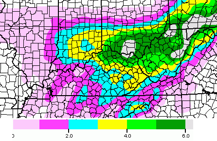
The GFS seems to be picking up on this well and reflects this with it’s latest snowfall forecast…
 That is very similar to the forecast I have out, so I will roll with it.
I also want to throw a word of caution out there about the radars. They won’t pick on on the rain/snow lines very well with this type a setup. That said, let’s track…

I-75 @ Winchester Road Lexington

I-75 @ Iron Works Pike Lexington

I-75 @ Clays Ferry Bridge South Between Lexington and Richmond

US 60 @ US 127 Frankfort

US 127 @ Frankfort Frankfort

I-75 at MP 36 London

I-71/I-75 at Buttermilk Pike Near Covington

I-64 @ 3rd St. Exit Louisville

Downtown Louisville @ 2nd & Broadway Louisville

I-65 @ 234 Near Bowling Green

Take care.

The meteorological way to say “bust” haha.
.if that comma dont develop then major bust
Ummmmm… NO
I hope your right, u are my fav met. Just pickin on ya
Tryin’ to play it off there, I see…
No not at all, he is my fav met and i hope he is right, but as it looks it will be a bust forecast and I’m sure he’ll be willing to admit if it is….
Nobody puts baby in a corner!
Well, maybe sometimes me, but that’s it.
ban plz…..
I second that ban
The back edge of precip entering Louisville and moving east fast, all do respect to Chris but frankfort area doubtful will get 1 inch, the comma head will Probably form east of I-75, so parts of east KY will do ok with that!
Thanks Chris! Your the best! I guess we are on the low side again.
Back edge of precip is almost to Louisville and we are still all rain here. There better be a giant comma pop up out of nowhere if we get 2-4″.
No dinghy then?
34 in frankfort and nothing but pure rain, this is another rain overachiever! Might change to snow but more than inch would be EPIC
😉
35 in Lawrenceburg. I cannot believe schools dismissed early here today! The roads are better now than they have been since last Monday!
They fell for the forecast hook, line and sinker!
Rain and 33 in frankfort, this might be the worst bust of the winter?
Not calling out METS, they were just going by the computer generated info!
Ever been an administrator responsible for 1200+ high schoolers-some new and inexperienced drivers, faculty and staff? No? then consider the weight of a faulty decision that ends up in mayhem, injury or death. Been there and done that…err on the side of caution!!!
Understand, but no snow was even near KY at the time of these early releases?
We didn’t even have school in Jefferson County and we are always one of the few that don’t close at the drop of a hat. At this point I won’t get out for summer break till July 4th.
Well the good news is that we will probably not hit the mid teens for lows tonight.
I wanted a good snow from this but I’m going to try and look on the bright side….less snow to melt and turn my yard into a muddy mess this upcoming week. Dogs plus mud equals a lot of paw wiping when they come in.
So you saying the rain we are receiving now and going to receive next week isn’t going to muddy up the yard.
Sorry just really frustrated at the time being.
Yeah, I didn’t think that through. It’s going to be a mess next week. This would have been a pretty good snow had the temps cooperated. Oh well.
This has to be the biggest BUST for Louisville in a long long time. Just six hours ago everyone talkin about 1″ plus an hour snowfall rates. I know some of the metro got in on some of the fun, but for what we where expecting to what we got is BUST city. Hope the comma head shows up for the rest of Kentucky.
This is NOT a dig at CB. No one controls Mother Nature.
This just proves once again how the models cannot hit a snow forecast just a few hours before it happens in this part if the world, it is simply crazy how other parts of the country seem to always get what’s predicted days in advance but here that never happens!
Nice call on the snow day for JCPS huh?
I don’t recall anyone saying anything about warm air or rain anywhere near the metro. Crazy how nothing but snow was predicted and we ended up with all rain.
I told you so lol
You mean Brian Goode told him so. That was the info you gave us…almost word for word.
But Brian did say there would be a bust factor in N. Central KY depending on temperatures…and he was right.
Sorry E-Town Ky read previous post i said this since yesterday morning and stuck to my guns BG did say about surface temps being key i agreed however nobody said it would get to 41 degrees today for a hi temp i did and gave my reasoning behind why i thought it would. I said from the beginning that the I-64 corridor would not get anywhere close to 2-4 inches. Also said it was a bad move to cancel school.
Bust in Lawrenceburg as well. I really doubt we see 1 inch of snow . The NWS had the changeover time earlier than now. 35 and raining—we might see some flurries overnight but if we get more than 1 inch, it will be EPIC!
🙂
Happy Valentine’s Day to Chris and all my fellow Weather Weenies.Just got back from Dinner.Chris it is raining now in Pikeville.I hope your Migraine is gone.It does look to be a bad night to be out so we took in a earlier dinner.Everyone stay safe and Happy Valentine’s Day!!!!!
Comma Head starting his swath of dis-struction on radar right now over Louisville. Given what day it is, the kill rate is going to be high!
http://youtu.be/avas-u4od6w
Check yo calendar…
Friday the 14th lol
lol…smh.
Alright, if you’re going to be anal about it…
http://youtu.be/IuY7GsM6tvE
The main divergence (OK, bust) in N. Central KY/S Ind. has been the QPF. I got 95% snow but probably only 1.75-2 inches of accumulation QPF was supposed to be .35-.5 range. So far only about .2, and will only receive at most .05 more.That’s why low end totals at most are looking likely.
33.2 in frankfort and rain, might see freezing rain at this point, where did all this warm air aloft come from, I thought it would start to snow while above freezing??
We’ve gone to all snow here
I really think this is a bust storm. No comma head to speak of for Lex and vicinity…precip is ending in Louisville and BG. I’m not that disappointed though. Bring on the 60’s and 70’s!
And no offense to the local mets, can’t win them all…
All rain all afternoon here in Hardin county. It does look like temps are crashing just west of my back door…bad news is the precip will be gone soon. Im now hearing little clicks on my window so a lil sleet?
I have been a longtime follower and love this site. Yet I have never commented. But I have been surprised by the level of ‘error’ both during the day and now this eve with the rain. At appox. 8pm the temp at the airport in lex was 37 and dewpoint was 35. Now I have been a weather weenie since a child and I know that temp cannot go below the dewpoint ‘on its own’ …..there has to be an influx of cold air and a moderate/decent one at that from the looks of things.
I am NOT complaining and was so glad to see Chris back in KY but I guess I felt the need to just put in my two cents this eve cause every hour that goes by i get a bit more confused, a bit more ‘tickled’ in a way, and just have to think what in the world went so so wrong today – and i am speaking of forecasts from all over, not this site….cause odds are this site is closer to reality that some of the others around here but this has been a bigggg ole miss from all angels i think
I guess Prelude was correct. I never discounted what he was saying. but I made the mistake at looking at the radar return this morning.
it look like the colder air was going to win
32.8 in frankfort still raining, maybe an inch of snow if we can get this warm layer away in the next hour or so, if not deck duster, that’s ok been a pretty good winter, bring on some warm stuff, that beats cold rain any day!
Stick a fork in it…carve it up…throw in a side of mud…
looks like we will run out of moisture before we get to the cold. that is honkey dorey with me. maybe this will wash away the remaining 2 inches of ice on my back deck.
“honkey dorey”
Living in central KY, this cracks me up. Sincerely, thank you.
🙂
Chris sounds ready to throw in the towel on this winter and I’m with him, golf, fishing, warm sun on my face sounds good, Chris has did a great job this winter no matter what the outcome tonight, hang in their ole buddy you deserve some down time 🙂
This is one of the few storms that will be a total bust in this area. Not Chris’ fault. I don’t think any model or any forecast had it above freezing this late into the evening.
I did, but am a true believer of the Torch and treat all that doubt as “Naysayers!”. 😉 A little tribute to John Travolta in the so bad is good, “Devil’s Rain”.
Bubba–keep the Torch on your side of the river. First time I’ve had a busted forecast this bad in a long time. Although it is amusing to watch the temp drop into the 20’s now that the precipitation is exiting.
The 33 degree rule is science.
Another laughable forecast here. I knew 4 hours ago it wasn’t going to snow……good gracious it was near 50 when it started raining, it dropped to 39 & has now been going up in temp!!
It has happened before. I can remember a few times with people talking temperatures and radar and no snow. Wake up and we have 2-3 inches. Not saying I think it will or will not happen here.
Ban Plz…don’t nobody wanna hear all dat junk. get cho own blog den holla at me.
The magic number must be 32.5, snow mixing in frankfort finally, now lets see that back edge develop and we might be in business?
It was, at first forecasted to be all snow along and north of I-65. Then mets started saying it may mix with rain at first but should quickly change over to snow. Then yesterday, they said rain over to snow. Today in reality? Rain, with rain changing to snow around 10pm. Dusting up to an inch along I-65 corridor. Some freezing rain is possible.
I-64, obviously! Seems like I don’t know my roads!
Wait until after the system has moved out completely to render your judgement, that’s all CB is asking.
Final prediction vs. actual results AFTER the conclusion of the event. If that comparison doesn’t work out tomorrow, then have at it on here. If it does work out, sing the praises. It really is that simple, so I’m baffled as to why this is so hard for some of you to grasp.
Most appear to be nowcasting, as in nothing appears to be happening right now. This is correct for most so far, and even nowcasters in the I64 area appear to not be getting much yet.
Yep, it could happen, but the flow from the west does not appear to be in sync with cold air. The ever present 33 degree rule might apply here.
That said, if it gets in the teens and not much wind, it will be slick and not worth driving anywhere later tonight. Even without much or any snow.
That is probably what is going to end up happening.it has been raining steady here for a good while with a few flakes mixed in at times.Still very warm at 40 degrees but wind chill is dropping the real few to around 30.
If it actually makes it into the teens tonight and freezes all this water that laying on the road ways they will be skating rinks even with no snow at all.
Rationalizing their behavior based on the percentage chance they’re correct or CB is correct isn’t going to work. It doesn’t matter what the outcome is an hour before, right in the middle, or an hour before the end. You. Have. To. Wait. Until. It’s. Over.
If I could give you a checkmark, I would. Good post.
I don’t know, it is close to 9PM and 39 degrees in south Lexington and north Richmond. We might need to get the dinghy ready after all. CB can be Skipper and I can be Gilligan 🙂 Not seeing how we get much of anything, but been saying that since yesterday, due to temperature. Warm Air is the begotten son of the Torch!
If they drop salt and the rain washes the stuff away, I will call it a win! Even the salt trucks at our local road & highways station are parked and waiting for rain to stop. All sitting with yellow lights on and idling.
It’s 40.4 degrees at the Lincoln County mesonet site & we may have 45 minutes of precipitation left. Sorry, shows over here.
I live in WV. There were several clues which led me to be skeptical of this storm. First our low last night was only 31, supposed to be 24. Today high of 49 was 12 degrees higher than predicted. Then checking the radar this morning and seeing the rain into southern Illinois. I had a feeling it was moving more north and we were doomed to another 35 degree rainstorm and then the dreaded wrap around dusting.
I agree Mark, but why can’t the mets see this stuff. It was 50 here today!
Made it up to 53 degrees here today.We are down to 40 now so I suppose it can still drop a lot overnight.
Raining here at my house.
I find it humorous that CB’s naysayers jump on the bandwagon when his forecast for their town isn’t 100% correct, but when he nails a forecast they are nowhere to be seen. Why even come to this site and waste your time commenting if everything you post takes a shot at CB?
That seems to be a little bit of a loose summation, but folks are not picking on CB. IF it is a bust (if), all the mets missed this and ditto for the models. IF it misses, another case where the models appear to not regress and “learn” from the warm air factor.
Still a lot of night left and CB said less than an hour ago he was sticking with his final call. He is the met and none of us are, so nowcasting be darned and let us see what happens! 🙂 …………… Oops! I need to get my wife’s Valentines dinner ready. Candles, fireplace, dinner, Barry White CD ready 🙂 Check!
Later taters!
I Agree Big Papa!! We may not see any snow here in NE Kentucky (Lawrence), but that’s not CBz fault. He goes by the data and interprets it. Just like my last snow. ALL of the local forecasters (Huntington area) said maybe a dusting at most an inch, while CB stuck with his guns and was right about the storm, EXCEPT, we got more than 4 in. we got 6 to 7 in. ! Don’t hate, just appreciate his effort and dedication!
well said, Big Papa!
If this ends up being a bust, I’m really not disappointed……….Why?
A) We’ve had plenty of snow & cold here.
B) Even if we did get 4 inches or more, next week is going to be warm so it will be gone anyway….If we get good snow, I prefer it follow with cold and stay cold…….
true word.
I will not be sad if we don’t see the snow. I am ready to start prepping for the garden. I can’t wait for fresh greens!
Turn off the lights the snow party is over….. Again,..
Stop that.Don’t give up so easily.It’s still early.
A mini blizzard going on Here in Louisville Blowing wind And snow. too bad the low is not moving more north. it could have been a backside overachiever.
Snowing moderate in Frankfort, starting to stick on elevated surfaces, the comma head might be developing right over shelbyville and frankfort area, I-75 east will get decent totals!
Yeah it’s snowing decent here in Louisville right now
If you guys can get a quick changeover You might be able to pick up around 3 inches.
A nice 33 degree rain in Lawrenceburg. At least it might wash some of the salt away!
The band forming just east of Louisville may get quite a few to the low end advisory levels predicted. I’m sitting at about 2.5 inches now, and will probably meet the low end 3-6 guidance for Oldham County. We were included in the WSW area, but did meet the old 2-4 citeria for WSW, so not going to beat anyone up.
Thanks Chris for your hard work and dedication to this blog. Sometimes I wonder why you bother, especially since everyone knows better than you anyway. 🙂 But I for one am thankful that you do.
snow mixing with the rain in Lextown.
nasty out on this Valentine’s night….
thanks Chris for all you do!
If you look at future cast on the radar it is showing snow coming behind all this that has went through later tonight and colder temps then.I wouldn’t say its a bust just yet.Still got quiet a few hours to go.
Personally I don’t care if I see no more snow until next winter.But if it comes it does and nothing we can do about it.May as well make the best of it.Once tornado season revs up I suspect this will look mild in comparison to what we will need to be concerned about.
NOTHING TO SEE HERE. move along. 2-5 inches aint happening.
fact is BAILEY the best in biz, and being a weatherman in winter is a bad job. its only job u can be wrong and still have a job.. I THURSDAY said warm air would bust this forcast… even a blind squirrel finds a nut ever now and then.
Well is is right a heck of a lot more than he is wrong.Even when he misses its usually not by much.I like the fact that he takes the time to post his reasoning as to why he thinks it will happen,etc.If he does miss it somewhat he comes back and tells us what happened.I have read here quiet awhile but never posted till lately.I would say its about as accurate as one would find.I think a lot of people forget that he isn’t obligated to tell us anything other than at the news site.So all of this is just an added bonus to all of us that are interested.
I think its great and its appreciated by many.
So I hear snow is mixing with the rain in the north side of Lextown. Still don’t see a flake just yet here in the south side, but I’m sure it should be here in several minutes.
Maybe the warm air with this storm is a sign of things to come. Perhaps next week we may reach 80 degrees here in Lexington!
Bailey……you’re the man!! Better than the rest. Cold rain, hoping for snow.
Gee..From sarcasm to jubilation..All in a matter of minutes…lol
This might bust in some places but not all, frankfort getting a good snow at the moment if we get an inch that is the low range 1-4 that was predicted!
Sorry Rolo but Chris said it could bust south!
Snowing in Lawrenceburg but not sticking. Don’t even have a deck duster yet. Maybe squeeze 1 inch out of this? I agree low end of the forecast.
Hats off to Prelude for hitting this forecast. I will admit I was off my game this time around.
With that being said, my neck of the woods (NE Lou), has 2.5″ of fresh wet snow. We are right on the Jeff/Oldham Co. Line. So, this helps. It is still singing snowing…just at a lighter pace.
This puts NE Louisville at 27.2″ for the winter. So, no complaining from me!
Snow is coming down here at a pretty good rate and quickly accumulating.
Chris –
I noticed WKYT has a nice webcam showing a large field in the hamburg area….It would be cool if you could link that cam when you post cams, I hate the clays ferry cam….
I really wish we had a better cam for London too.
i hate that cam too, but it shows the crazy difference in snow sometimes. just 15 minutes up the road on Iron Works can sometimes be a difference of no snow here at Clay’s Ferry to a couple of inches there. that has always fascinated me.
Snow now mixed with the rain here in south Lex.
Here’s the thing. You post 2-4 inches and intimate that may be low. If you forecast 2 that doesn’t get buzz going. If you forecast 1 inch then you can’t put school administrators “on notice.” They don’t dismiss early and there’s no buzz. This almost blind allegiance to the models reminds me of the old joke that ends “are you going to believe me or your eyes.” NWS L’ville has pretty much given up on this but just doesn’t want to say it yet. Bring on spring. Easier to forecast rain, t-storms and even tornadoes than snow in central KY.
I’m no met but I am observant. Yesterday I predicted all rain for Madison county and snow for Fayette county and points north. Based solely on what nearly always happens regardless of the forecast. I don’t know why this event would have been any different…
Thanks CB for another spot-on forecast! I left the north side of Lexington at 5:20 and it was 37 degrees and raining. After crossing 460, the temp dropped to 35 and the rain changed to a wet mix. By the time we crossed Hwy 62 at Leesburg, it had changed to all snow. When we arrived home at about 6, it had been snowing steadily for a while and the melted areas were getting covered up again. We got the horses up and their wet blankets off and all the ground had been recovered with snow. At least 2″ of new accumulation has fallen btw Sadieville and Cynthiana since we arrived home and it’s still snowing like mad. No forecast is perfect, but for those of us who depend on an accurate forecast to care for our livestock trust CB more than anyone else. I know when I check his forecast if I need to bring up my horses, put on their waterproof sheets, or bundle them up in their warmest blankets and neck covers. I can’t afford huge vet bills, so I need to know how to keep them warm, dry and healthy. I also need to know when the mud monster arrives so I can get hay out while the ground is still frozen and not total slop. I grew up in the north, and forecasting up there is easy — it blows in MN and sucks in IN, so wind and cold are predictable. Here in KY, only CB knows what’s going to happen, so I keep checking. Keep up the great job and keep popping the Advil. (I knew this front arrived when my stopped splitting open.)
Thanks and Happy Valentine’s day all!
Very nice post Monica! Kudos to you and thank you CB for providing this blog for us weather weenies. I depend greatly on your insight as well,since I travel a lot. I know you do not get paid for doing this and it is done by sacrificing whatever spare time you might have available. You the best.
“Again… watch the wraparound snow with that low! The bust potential could end up being on the low side for some areas.”
Guess not.
Now all snow in Lex. Though not accumulating at all and it’s snowing lightly. The backside of precip. is just about here. We’d be lucky to get a dusting here.
Got a deck duster in Lawrenceburg. No shoveling required. With the precip moving out, I would call this snowfall at best a trace–perhaps a few tenths of an inch. I live about 8 miles south of I-64–so if the I-64 corridor was the dividing line, this snowfall must have been well north of I-64.
Pouring the snow here in greenup
Officially ready for spring. Hope next weeks warm up lasts until next winter. Oh yeah they need to throw all the models in the trash and go old school on forecasting.
Agree models are useless I know the weather better then a model
I would just like to second that Bailey is the best in the biz. If he’s going to get it wrong, everyone is going to get it wrong. Fact is when you see temps head above 40 around here its always going to be a bust. It was surprising with snow on the ground that it got that warm. I hope the next cold spell is a bust and spring is here. Cya next winter.
Well–despite this miss on the snow, I’m not into Spring Fever mode yet. It is just Mid-February. I can hold off on mowing, severe weather etc. for quite a while. How about some days with sun and highs in the 40’s and 50’s? Sounds good to me.
Actually, until the clouds moved in, today was beautiful….almost 50 & sunny skies. My kind of weather!
I wish it had hit 50 here. I think 39 or so was as high as I saw–still the warmest day in almost 2 weeks.
Heavy snow in central WV accumulating on everything. It also hit 50 degrees today after over a foot of snowfall yesterday.
LOL. Chris just mentioned and showed the DOME over Madison county! Snow must hate BubbaG!
On WKYT of course…
It is as real and settled science. People thought I was crazy eight years ago when I was walking around with a cardboard sign. Hah! Whose crazy now?! Hmmmmm?
I’m a good driver.
When is the comma going to form? Waiting and hoping!
The comma is dead on arrival or maybe missing in action. There’s just no chance, no chance at all.
Snowing in Ashland KY now.
Interesting that this winter will end up (barring a major snow/cold outbreak in Lexington) as only the 3rd coldest/snowiest in the past 5 years. Everyone has been screaming about how cold it has been, but that is not true. We have had an a very cold January and beginning to February but December was mild and relatively snowless. Looks like the 2nd half of February will be the same. That being said, I think the winters of 2010 and 2011 were underrated. 2010 was one of the 10 snowiest calendar years in Lexington history thanks to a Top 10 snowiest February and December! Also those winters were the two consecutive snowiest and coldest since 1978 and 1979.
Channel surfed Lex newscasts and the anchors all talked about the “winter storm” in Lexington! Love those live shots of rainy Man O War at Hamburg. How can they do this with a straight face? And I wonder how many restaurants had cancelled Valentine’s reservations because of this forecast?
It’s all about grabbing viewers with “catastrophic” & “crippling” headlines. The sad thing is, it works. No matter how many busted forecasts, people keep watching, because, well there’s another “storm of the century” lurking…..
Sadly, This.
The comma is there..don’t you notice the snow barely moving and kinda wrapping up in a circle
The comma busted. Period.
K bud
^Wow! Amazing!
-Duck Dodger
i wonDa if this weaTher has any effect on da herrington Lake Monsta? I seen one carp looKin fish musta bin ova 38 ft long witta nose like a allygator.
Accuweather finally dropped their 1-3 inches of snow call for Lex and now posts rain for Wed-Thu in its place. Looks like back to the drawing board with those models. Radar showing warm air east of Lex pushing rain all the way up to the Ohio River. Didn’t see that forecast anywhere.
A lot of people talk dome, but we folks in Madison Co. not only have the on the ground proof but we also sometimes can catch glimpses of it on radar.
Don’t judge the asymmetrical shape, we went with the low bid contractors.
http://imgur.com/dis9EGq
Enjoy the snow central and eastern KY. So glad the forecast busted in the Louisville area. Really I am. Bring on the Spring (the other B.O.T.S.).
This system was not a game changer.
no matter how much it snowed it was going to melt away by mid week.
Brian Coniglio, a meteorologist with the National Weather Service, said the snow totals were lower than expected due to higher than expected temperatures.
……. That again is as surprising mint juleps at the Kentucky Derby 😉
A good carpenter never blames his tools.
…measure twice…saw once…
Just over an inch here in East Morehead… Pouring snow… Radar shows rain? Hasn’t been raining for over an hour. I’m thinking we’ll have the forecasted 2-4.. Maybe on the low side… Maybe not… But not a bust here (wish it had been)..
Well its blowing like crazy here and light snow even though none is showing on the radar for this area.Temp is still about the same.But it looks like snow is starting to show up in wrap around bands to the northwest that will come across us later tonight.I don’t think this is over yet.
Can someone give us a geography lesson: Which counties are in central KY, i.e how far west, north, east and south of Lex is central KY?
Where I grew up (Madisonville) I considered Bowling Green and E-town to be Central KY. Paducah was Western Kentucky 🙂 When I moved to Lexington in 1996 I was shocked to hear the locals call it Central KY. I always had thought of Lexington as the Eastern part of Kentucky. I think it is subjective dependent upon where your live.
This is a good question and I don’t know of a definitive answer.
http://geology.com/state-map/maps/kentucky-county-map.gif
As a quick reference, I always just pick the counties surrounding Fayette Co. and a couple on the outside of those as you go around in a circle-ish pattern (like Garrad and Mercer).
Technically, or “geographically” speaking, the center of Kentucky is in Marion County–but a lot of the folks in Lexington do call it central KY. I tend to think of Bowling Green as more west-central.
Louisville–northwestern
Covington–northern
Pikeville–eastern
Somerset–southern
Lexington–central
Paducah–western
lol *shrug*
Have about a quarter of an inch here on the south side of Lex and still coming down.
Well, if this does bust for most, the movie tribute will be:
The St Valentines Day “Metsacre”, starring Dolly Parton and Rolo.
In 3D!
Seriously, what is wrong with you?
It’s just Bubba being Bubba. Nothing any of us can do except play Nickelback to drown him out hah. 😉
They hit it all wrong with the temperatures, even Chris did. Here in Morehead we had mostly rain until about maybe an hour ago. According to the radar its almost moved out so more than likely we might get an inch instead of the 3-5 they were giving. Basically, it was too warm and most areas got rain which all forecasts missed. It was a bust.
Why are you complaining then?
NWS takes frankfort out of the advisory and guess what, a nice little band of snow starts developing on top of us LOL 🙂
Same here in Lawrenceburg with much lower temps. Down to 23–whatever falls will stick. Still waiting for my wife to get home from work in Lexington.
Chris’s forecast is on point, Snow has been falling in Lex near Hamburg since 10pm. Half inch so far, and heavy snow falling now. The radar showing nothing. Wish some people could be blocked, it’s silly really. Winter weather is extremely hard to forecast. It is nice to discuss and chat about, however when the comments become mean and harsh make me want to stop reading. I previously worked in the biz in GA, and FL and it is a little easier, somewhat, CB gives his time and dedication to this blog and people disrespect, but those have no clue…Those who have had education in meteorology and are in the biz know otherwise.
…barely a dusting at all in eastern Jefferson Co…was hoping for so much more. The county schools even called off school for the day fear of the impending winter storm was supposed to develop. Come the usual dismissal time, it was only rain they would have needed to contend with. I am still pinning my hopes on the coming of the Coma Head.
Heavy snow in frankfort, roads are bad!
Same In Lawrenceburg. Why drop the advisory when we are finally seeing accumulating snow? Makes no sense to me.
If I were Chris and I read some of these posts, I wouldn’t want to do the blog any more. BUT, please don’t take it away Chris. Some people are disrespectful and wanna-be meteorologists. The rest of us really appreciate your hard work and the time that this blog takes away from your family. Thank you from the bottom of my heart for keeping us up to date on the weather. You are the BEST!
4.8″ of snow at CVG tonight will push us over 40.0″ for the season. I live about 15 miles east of the airport and looks like about the same amount of snow fell here. I had to drive 10 miles in the stuff, but fortunately there weren’t many folks out on the roads.
Chris is not trying to grab headlines by scaring people. What a foolish and ignorant comment to make.
Who is that comment for?
Snow totals may be a bust, but overall impact to roads and driving conditions are the same. Winter weather advisory or travel advisory for overnight period still stands.