Good Saturday to one and all. Snow will be winding down across central and eastern Kentucky early today as frigid temps return. After one more light snow maker rolls in tonight… it’s full steam ahead toward a taste of spring for next week.
Our Valentine’s Day storm slowed down on us and that allowed for some warmer air to shoot into areas south of Interstate 64. That kept the rain train rolling longer than I thought and that really hurt my forecast for some of those areas. Northern Ky worked out well… but that has been the snow king all winter, so that’s not a surprise.
For those of you who missed it, the snow really kicked into high gear across the Lexington metro just after midnight. A quick inch or two with 30mph winds caused major travel troubles as roads quickly became snow covered. Here’s a snippet of road conditions around 2 this morning…

One more light snow maker swings in here tonight and Sunday morning…
This will come after a day in the 20s with a gusty wind making it feel much colder. Some leftover flurries will be around on Sunday with highs in the 30s.
This leads us into a milder Monday with thermometers in the 40s and the chance for showers. That will be the beginning of a much milder week that will feature temperatures working into the 60s before the week is over. We may also see showers and thunderstorms roaming about the region by the end of the week. Check out this setup…
 Can we get some strong storms from that by Thursday? I guess we will wait and see.
Anyway… I am ready for spring, but next week will be a false start to spring. The following week will bring the return of winter and the pattern has a rather ugly look to it into early March. That does not make for a happy weatherdude.
Have a great Saturday and take care.

You still have a high batting average, but that big precipitation hole you showed over Richmond on TV tonight kind of hurt 😉
Figured you would like that. 😉
Isn’t a high batting average in baseball in the 35% to 40% area?
Usually above .300
You all know what I meant. Stop trying to be subversive 😉
My only solace is CB showed irrefutable evidence of the D word. This is as significant as a “real” live video of bigfoot! 🙂
Yes – everything is once again WHITE in Lexington……Unfortunately…..
If march looks to make our head weather weanie upset, he must see cold/ winter for first part of March. March 1st starts spring weather season for him. I’m glad we got chris here for tv weather. We need the best if severe weather season is half as bad as march 2012 storm.
Still snowing lightly here and the wind is gusting.Temp has dropped to 22 degrees and it feels very cold.Just checked and we have a good dusting that is covering everything.The snow hasn’t showed on the radar all night.Its been light but steady.
The snow is so bright and it sparkles,an icy look.Didn’t really think we would get this much.I was hoping this would be the end of winter but tornado season worries me greatly this year.Seems like I have had heat going since late October.A nice calm day would be so great.
Just went outside to check the weather and it is very cold.The wind is still blowing.We have a thin layer of ice under a thin layer of snow.The snow is frozen hard so can’t really sweep it off.Extremely slick.
Half inch tops in SE Lexington. So was it only because the system slowed down (and what causes that?) or did the track also take a more northerly path than was forecast? Or did one cause the other?
Truly trying to understand how high temperatures yesterday were so under estimated by all the models and why after that was observed forecasts weren’t changed in response? The NWS and local mets all “stuck to their guns” on snowfall amounts in the face of the nowcasting going on right up until the moisture was almost gone.
Chris I’ve learned a lot from this site this winter. Thanks for taking the time to do this.
Allen…that’s crazy! I’m on the NW side of Lexington and easily received 2″! Crazy cutoff!
That cutoff must’ve Been sharp! Here in south central lex we have almost an inch.
I’m in the Masterson Station area… I would guess that we are just below or right at the 2″ mark… maybe 1 3/4″ if I account for the blowing… My parents live in the Hamburg area. We had been all snow for 45 minutes or so last night on this side of town before they saw their first flake! Crazy!
Exactly! I heard it was now pure snow last night in Lexington (but on the north side), I looked out my window and not a flake in sight. It didn’t take ’till about an hour later until us in the south side turned to all snow! Crazy, that rain/snow line was moving so slowly.
If I round up, we got .5″ 🙂
Light Snow falling in Pikeville.Thanks Chris for all you do.
Good two inches in Olive Hill and still snowing very lightly. Glad we didn’t get any more. Power lines are all sagging.. Heavy stuff!! Thanks Chris for all you do!!!
only ended up getting abt an inch here! still snowing slightly and 22 deg.
Deck duster here in Carrie of knott county, no complaints from me I’m in spring mode
beautiful coating of snow in Lextown ( maybe and inch?)…flurries still drifting around.
Spring and 60s sounds good for this snow lover but yeah, I’d welcome another round come March if we can get a nice SNOW!
thanks Chris.
go Big Blue!!!
Light snow falling now in knox co
Just look at the ironworks weather cam and the winchester rd weather cam. Look at the difference! Here in northwest Lex is definitely over an inch…..possibly 2 but not sure………just guessing……
currently upslope flow squeezing out decent moderate snow across Leslie county…at least 1-2 inches coating everything
Please stop snowing..Looking at radar this just blossomed like crazy….Snowing hard to..
Snow is really coming down now.
CVG picked up 4.8″ of snow last night. This brings our seasonal total in Northern KY to a staggering 42.8″ which is 27″ above normal. 🙂
What an outstanding winter in NKY! 🙂
Congrats on getting ALL the snow I’ve missed. As “fun” as this winter’s been for cold and snow tracking, it’s been equally frustrating for all the snow I’ve MISSED. Yesterday was another prime example as the temp ticked up to 37 degrees — as Chris mentioned more warm air got involved — and we had RAIN after having a 2-4″ forecast from the NWS. It’s hard to believe but this snow lover is about done with it. If the late Feb/early March is bringing more near misses, then let’s get on with spring!
🙁 Keep on! Just another point building a case for a North Kentucky and South Kentucky. 🙂
Them North people are takin’ ar’ snow!
Roads are snow covered AGAIN…Goes another salt truck AGAIN..Almost 2 inches laying atop what was left yesterday and still coming down AGAIN..
2 inches of salt ? 😉 just kidding
Oh that’s what i meant…2 inches of salt laying on 2 inches of salt..lol..Mother natures wash job last night will be no good for today..
not here either as we got yet ANOTHER coating about 9 or so
Woke up to a couple inches here south of Lex. I was in the 1-3 inch range on Chris’ snow map, so he hit it dead-on again. The Chicken Littles last night doubting Chris must feel stupid, again.
i think they were doubting his 1st Last call maybe not his Last Last Call
Not sure what that means, but I got what was forecast back on Thurs night.
Pouring the snow in Bell County! Everything is covered!!!
Still snowing here in Leslie County. Would love to start planning the spring garden. Hard to be inspired with white ground. White on grey with grey on white. Want some warm yellows and greens. Patience is a virtue.
Beautiful snowy morning in Berea with some flurries still coming down. Our accumulation is close enough to 1″ that we’ll call it just that. Our minimum forecast amount was 1″, so this is a successful forecast for our area. Berea total since Oct 24th reaches 12.5″.
However, this was more pleasing to see than the snow…
“Our Valentine’s Day storm slowed down on us and that allowed for some warmer air to shoot into areas south of Interstate 64. That kept the rain train rolling longer than I thought and that really hurt my forecast for some of those areas.”
A brief explanation and oops statement after a generally unsuccessful forecast (though correct for any 1″ min areas). Before the chief met days, CB used to do this years ago every time something went sideways and I’m glad to see it return. He took his mistakes to heart and subsequently wore it on his sleeve, which is why I became interested in the first place back on the original blog on WKYT. Thank you, Chris Bailey.
Not that he ever really was not humble, but I generally agree here.
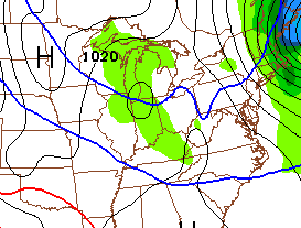
Well, he did kick us Richmond folks while we were down. That map graphic of the circular like hole over our great city (The Gateway to the South and Protector from the North) was kicking us while we were down. 🙁
Well played, CB! 🙂
Thankfully it has stopped now and the sun is peaking through..I measured 1 1/2 inches..This was in a 30 minute timespan..Really wild there for a moment..Imagine if one could get a snow for 12 hrs like that..
Versailles was lucky to get 1/2 an inch. Wouldn’t be so bad if it weren’t for the fact that a week or so ago we were looking for 5-10 inches that panned out exactly like last night. The models seem to struggle with temps as the moisture was certainly there.
So after the first week of March,are we expecting spring weather then? Unlike last year? Wasn’t sure if anyone knew. I am so ready for Spring and warmer weather.
I haven’t posted on here in the last week or so, but as always, I’m very appreciative of Chris’ efforts. We received a lovely 7″ snow here in Harlan County on Wednesday night/Thursday morning, and it’s pouring snow again as I type this. Weren’t we supposed to be under a Winter Weather Advisory this morning?
I hope Coffeelady and others who haven’t seen much snow this season get their turn before winter is over.
Everything is snow covered here again this morning, and it’s still snowing. It’s very pretty. I am so ready for an early spring, but I am enjoying this pretty snow too. (As long as my electricity doesn’t go off). 🙂
Still snowing lightly here in OH. Ringing out every bit if moisture it possibly can. Loving it!!!
Come on Spring 🙂
Now that is uncalled for. Well, not really. Seems that even snow lovers are calling for it.
To bad next week could be a false start to an early spring. Seems that weather.com has a nice warm week coming up only to return us to 34 for the high the following Monday. Seems to follow with Chris and his false start. For once I hope they are way off. My driveway did not near completely thaw yesterday and was slushy on top and still solid enough on the bottom. Froze back up last night to make a nice ice block and then the snow hit late and put a good layer on that.
What’s that I see out there in the upper Midwest??? Looks like it’s headed our way..
Probably the little clipper that is supposed to get in here tonight..
Appreciate your work Chris. Looking forward to the false start. Is going to be nice for some warm days. And to bad it is spring that is false starting. Spring is apparently going to see a flag thrown and be set back 5 yards (winter should of had a flag for unnecessary roughness and holding instead). . No wonder winter is able to make a comeback. Spring needs to hold winter to a 3 and out next time and then put this thing away. Time for baseball. And Spring better not be bringing the heat (big heavy rain) and throw a pick 6 (inches plus of snow) or some other big event (think ice). Spring needs to watch its back side for a safety blitz. Nothing like raining it down only to have the defense sneak in with a cold hard shot of smack down.
NWS Louisville discussion saying severe weather possible with the warm up next week.
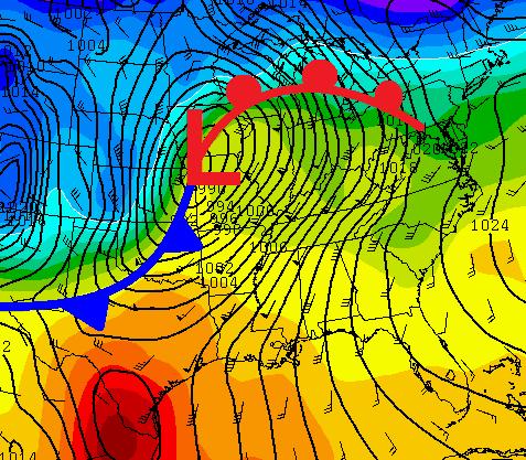
Here’s a good graphic of where the low actually went and where the models had forecasted it to go. http://www.crh.noaa.gov/news/display_cmsstory.php?wfo=ind&storyid=100474&source=0
Wow, I litterally came here to post a comment of exactly the same link you put. You beat me to it! lol
About 1 inch of snow fell east frankfort, so the very low end of the 2-4 that was forecast, but that’s fine snow on the ground for 2 weeks straight is enough, ready for the warm up!
I got about 1/2 inch in Lawrenceburg. Enough to cover up the spots where the sun had melted some of the snowpack. 2 weeks ago today it was in the 60’s–and the snow began falling on February 2. I can’t remember the last time we had snow on the ground for half of a month. Pretty impressive run. My utility bill will appreciate the warm-up!
Had about 2 inches of snow upon an inch of ice, all the rain last night really has created an ice pack underneath the snow in Southern Pike County this morning, still snowing a little.
We had a skiff of snow this morning, and the car doors were froze shut, the snow lover in me keeps hoping…
If I did not have to put kids through college, I would have enough money to go on a vacation to a snow mecca: Covington Kentucky 🙂 You know, hang around and be cool. Mingle with our northern snow aristocracy. Be one with the snow.