Good Saturday afternoon, gang. Another round of light snow is on the way to the region overnight as a weak system dives in from the northwest. This can lay down light accumulations before we begin to focus on a active weather week ahead.
The band of light snow will arrive by late evening into the wee hours of the morning. The greatest concentration will be across central and eastern Kentucky where a coating to an inch will be possible. This may cause slick spots to develop by Sunday morning.
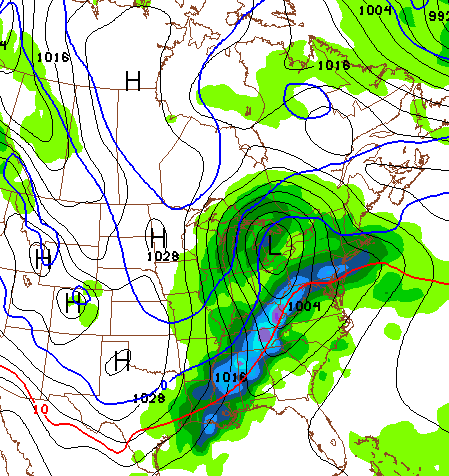
Regional radar will help track the action…

The week ahead will feature milder air and several systems rolling across the region. Temps will slowly warm through the 40s.. the 50s and may hit the 60s by the second half of the week. That’s when we have to be on guard for thunderstorms blowing up. That looks to be true on Thursday then again next weekend as old man winter fights back…
A pattern like that could lead to some strong thunderstorms as temps go from much above normal to well below normal in just a few days…

There is still some winter left in the tank for the last week of the month into early March. Can we just go ahead and throw up the white flag of surrender?
Take care.

Thanks for the update. I wonder if this pattern will be like February and March of 1996–a wild pattern for sure. It hit 80 in Lexington in late February (the all-time record high for February) after having been -10 earlier that month. A 90 degree swing in one month! Then in March we had two fairly good sized snow storms and a day with a high in the teens.
No surrender.
We the noble and humble people of South Kentucky, declare a snow armistice with the snow greedy people of North Kentucky. You have taken the white magic away from us for far too long. Have a heart.
Would you guys like to buy some snow shovels and sleds from us, for pennies on the dollar? Fair trade is a sign that we can all get along. 🙂
I’d love a shovel! Mine broke 2 storms and the stores here look at me like I’m an irresponsible pagan as they say “We’re sold out”
I bought an extra shovel for the expected big snow a few weeks ago. That one panned out like yesterday too 😉
Already raised that flag Chris. May have to keep it up as Spring comes on. With our luck it will be a rough Spring storm season.
Unfortunately, there is some potential for severe t-storms late next week. Potential being the key word, as it’s way too early to get a good grip on things.
Still, the European and GFS models are hinting at this chance of severe wx. Over at the Storm Prediction Center website, their Forecast Discussion is already talking about these chances late next week.
Regardless of what happens next week, this is a good time to get ready for the spring severe wx season. Including reviewing tornado safety rules, making sure wx alert radios and other early warning devices are working properly, etc.
The NWS is always looking for storm spotter to join their network. Even with the increase in technology such as dual-pol radar, there is still a need for “ground truth” to further confirm tornadoes and other threats in order for the NWS to convey more urgent warnings.
test
another test
CB, great site, but you really need to adjust KWC’s posting auto-mod as it is way overkill at times.
Unable to post about upcoming storm s p o t t e r clases.
Look up SkyWarn via your local NWS office website
I would think a flood threat will arise for areas with lots of snowpack on the ground this week if large thunderstorms and heavy rains show up late week??
I wondered about that as well. I would say the ground will remain frozen for several more days leading to run-off issues.
Indeed, the Northern Indiana office of the NWS is advising their area about this very issue. Of course, they have more cold and much more snow pack. Ft Wayne to date is having their second snowiest winter on record!
Still, parts of southeastern KY did get about a foot of snow recently. And CVG airport in northern KY has had about double their normal seasonal snowfall.
We shall fight in the streets,we shall fight in the hills even with a salt shortage..We shall never surrender…We shall..Okay i give up..
Last night as I was leaving Krogers with supplies for the upcoming swath of snow 🙁 I noticed something I haven’t seen in several years. A snow pile in the parking lot. At some point and time we must have gotten enough snow in Versailles that they had to have a snow plow come in and move it around. There weren’t many but I saw one pile that was at least 3 feet tall.
Maybe next week WalMart will stock sleds again in their Central KY stores.
Walmart bases stocking policies on actual demand 😉
Tennessee starts their Severe Wx Awareness Week tomorrow.
http://www.srh.noaa.gov/bna/?n=swaw2014
Kentucky and many other states have Severe Wx Awareness Week during the first week of March.
Ridging over East Asia, storm in the Gulf of Alaska, equals a trough in west conus, ridge in east. Zonal flow, low level jet equals snow in north and severe in south around the 23rd.
Dodger is ready for spring. Tired of winter systems that look promising but are loaded with virga, warm air advection, last minute north shifts and cold rain. Dodger!
The trends of Kentucky winter weather all rolled up in one comment. Amen!
Local news here in charleston says this past January was the coldest since 1978. My electric bill confirms that
It’s that global warming thing.
Pretty nice looking band of snow on radar coming from southern Illinois, wonder how much is reaching the ground? Verga storm tonight maybe??
No green or pink that is a good sign. Could it overachieve? Very light, but with colder temps could still cause travel issues.
What is snow? ;). Haven’t seen a decent one in so long I forgot what it looks like. Thanks Chris for all you do. Whether it snows or not, you are still the best there is in these parts.
Uh oh! Even a slight tiny bit of a hint of sarcasm from Coffelady means it really has been a winter snow bummer.
Has anyone ever noticed her username is not coffeelady, but it’s coffeady? Out of the year and a half I’ve been following this blog, I never noticed that until now.
LOL 🙂
Very true! Lol
Hey coffee…I had 9″ here in southern tn…I think Pulaski co. Is snow drought city..lol
Hi Tim, my folks near Chattanooga/Cleveland TN (of course just southwest from you) got about seven inches. But it sure started melting fast, though.
blizzardtim had to move to southern TN to get more snow. He got an inch or two more in TN than his old home in Knox Co. got on the year. Congratulation. Who would know that you need to go south to get more snow. Only in Kentucky no doubt.
Dude, don’t rub salt in Coffeady’s wounds….nicest lady on this site. She wouldn’t do that to you.
Yet another test
SkyWarn
Irving Kentucky
See this link about SkyWarn
http://ow.ly/i/4By1v
This is best I can do. When I combine all this info about SkyWarn, my posts are blocked for some unknown reason 🙁 .
KET
Monday, February 17, 10 pm
Severe Weather: Staying Safe
10 pm EST
My backyard holds water even though I live on a hill. I have more ice than Sochi now. It’s really deep and I could luge if I had one. It’s gonna take more than a day or two of 60’s to melt it.
hey, I always read ‘coffeelady’ in my mind’s eye, also! LOL…I enjoy all of the input by everyone, and count on Chris as my weather guy!! Ready for Spring…
No surrender until London, KY gets a foot of snow!!!!
So about that band of snow?
Like all the rest it will either A. Be virga B. all move to the north or C. Both
MORE SNOW TONITE THAN WE SAW YESTERDAY FOR 90 PERCENT OF THE peeps.. uk!!!!! blueeeeeeeeeeeee
Rain ate it for the last one and dry air might eat some of this one. The radar shows it over some of us, but nothing hitting the ground so far.
free to a good home….. loads and loads of lewis co. snow. Enough already!
Snowing better right now in Greensburg than it has all Winter!!! We might get an inch or better out of this. Had less than 5 inches all Winter.
Lay off of ‘Coffelady”…she’s a sweetie!
BTW: LOVE the big ol’ “Donut Hole” around Nelson Co/Bardstown…and yeah….I’m a “Debbie-Downer”….I’m gonna go find Bubba…we can build a “fence”….?! ;0
Snowing VERY lightly in Lex. I can see isolated flakes surviving from the dry air aloft. Now that the atmosphere is starting to saturate, that band of snow to the west should drop its full potential. (That is, if it doesn’t dissapate before it gets here)
I still can’t believe it’s only FEB 15th at this point…….This winter has been so long I feel like it should be Derby day by now…..
Jeepers. Would be nice if the coach who is the mature adult would not be a baby to refs and cause a four point momentum killer. The team played hard too. Free throws though are a potenially “fatal” flaw going down the stretch.
Agree, fouls kill ya, we made Florida look good tonight by just being young and Dumb! These Cats are not going to dance much in March!
Hate loosing to a football school that owns us at that sport!
Geez….ANOTHER “donut”….??!! I hate to say it, but I am throwing in the white towel that I wipe my dogs’ muddy paws off with when they come in from the skanky little toe-bitin’ snow’s we’ve had lately.. (has it been 5 yrs. already???!!)
We have a good ground covering now, ironically more than we had this morning…
Nice little snow shower falling in frankfort, another deck duster then bring on the warm up, had enough of winter for one year!
Snowing heavy in lex, currently have about a quarter of an inch and still one more band to go.
Israel… we’ve got another good hit on this side of town… not a flake in the air now, but it definitely left it’s mark… A bit over an inch…
When I left for from campus after the game for my ride home the roads were clear… Once I rode into Meadowthorpe the roads started to become covered. By the time I got into Masterson, everything was covered! It was a rad ride home!