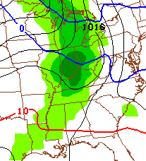
Good Sunday to one and all. A fresh covering of snow is blanketing much of central and eastern Kentucky to start our Sunday. This is all part of a winter that seems like it will never end… until now. Changes continue to show up for the week ahead and this may give some folks a case of spring fever. Though, I’m not as impressed as I once was with this warm up.
As mentioned, today starts with another light snowfall. Some areas may come in with more than an inch of fresh powder and roads may be snow covered early. I have your usual cast of tracking toys…

I-75 @ Winchester Road Lexington

I-75 @ Iron Works Pike Lexington

I-75 @ Clays Ferry Bridge South Between Lexington and Richmond

US 60 @ US 127 Frankfort

US 127 @ Frankfort Frankfort

I-75 at MP 36 London

I-71/I-75 at Buttermilk Pike Near Covington

I-64 @ 3rd St. Exit Louisville

Downtown Louisville @ 2nd & Broadway Louisville

I-65 @ 234 Near Bowling Green

The milder weather of the next week gets started on Monday as temps rise all the way into the balmy 40s. This gets tempered by a round of chilly rain rolling across the state late in the day…
Tuesday looks to be a better day with some sun and temps in the upper 40s. Another weak system may knock temps down again by Wednesday.
If you’re looking for a nice surge of spring temps, it looks to come Thursday. That’s when thermometers make a run toward 60 degrees on a gusty southwesterly wind. This will be ahead of a cold front that sweeps in Thursday night and Friday with a round of showers and thunderstorms…
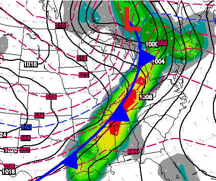
Colder air follows that and this starts the ball rolling back into a wintry pattern for the final week of February into early March.
More on all this coming later today. Have a good one and take care.

tx cb
I have no idea what the ground looks like without a blanket of snow.
I have no idea what the ground looks like with a blanket of snow. My deck has a bit on it this morning and my niece in Oak Ridge TN ( south of here) got two inches overnight. Oh well whatever.
Thanks for the update Chris . Have a great Sunday everyone.
Hmmmm. It seems it might take just a little nudge to get Cof over to the Dark Side 😉
Such an addition from the Good Side of the Force would make the Dark Side unstoppable….. Jar Jar, I have a job for you!
Surely people did not think something so bad as Jar Jar was not on the Dark Side. Makes complete sense.
Since Wednesday I have had about 15 inches of snow, a soaking rain that has turned all that into about 4 inches of snow and 2 inches of solid ice. It will take several days of warm temps to melt this away.
This winter has at least been pretty. Not simply cold and gray/brown. Chris, I don’t know what my family or I would do without your weather wisdom, thsnks. Does anyone know how long we have had snow on the ground?
I woke up to a fresh white snow this morning too. This was on top of snow we already had. I agree that it’s pretty, but I would love some 70 degree weather. 🙂
I wonder if this is it? Winter is over? Next will be will warm but what happens after that? I wonder if in mid feb we’re pretty much done with winter? Seems everyone seems to think it’s pretty much over…….I dunno though……things can still happen up through April……I guess we will see.
Winter IS NOT over yet. I think we will still see a couple of decent snow systems gliding by until mid March possibly, though I don’t think were gonna have winter-like temps until april or may like last year. I hope I’m wrong and winter doesn’t come back at all.
It wasn’t to bad last year i had my garden out 2 weeks before Easter
Not frost wise, but sweater weather lasted until near the end of April with highs in the 50s and 60s with lows in the 30s also.
Almost a freeze on April 25 and a low of 33°, but that was here in lex.
I agree with Israel. May not have been a late frost last year but temps ran well below normal up into May. One of the coolest springs I can remember.
I guess March being so cold made it seem a lot worse. Usually you start getting some decent days, but last year average highs were almost 10 degrees cooler.
Balmy 42 here in my part of knott county.
SPC giving an outlook for severe weather for Thursday over parts of western Kentucky, so ready for thunderstorms and warm weather, this has been a rough winter, even C.B. has said he is ready for warm weather and I would have to agree!!
Today has been the 14th day of 2″ or more snow on the ground in Lexington, that’s 2 weeks straight! 21 out of the last 26 days has featured a least a trace of snow on the ground, that’s 81% of the days. If you want to count within the last month, 23 out of 30 days has had snow on the ground (77%)
And lastly, 11 out of the last 14 days has had at least a trace of snow falling from the sky. (79%)
according to the cams he has posted theres no 2 inches on the ground in lexington today….chalk today up in the trace category, the piles in walmart parking lot dont count
North side of town (Iron works pike cam) has around 3″ of snow while south and east lex (Winchester cam) has a trace.
It’s very different around the city depending on where you go. (My place has ~1.5″)
Besides, the official reading for snow depth is at 7am at the
Bluegras Airport, they measured 2″. (Had to comment into tiny fragments to put whole comment)
Frankfort has had snow on the ground for 14 days in a row, glad to see it go this week, sounds like a short warmup coming then possible more snow, 22-24 inches total for the winter in east Frankfort!
don’t know why but it is snowing here in Athens Ohio still have about 6″s on the ground still