Good Monday to one and all. We have arrived at the week that we’ve talked about having a warmer feel to it. While that is technically true, it won’t be anything to really write home about and it looks to be rather brief. Old Man Winter is not done with us and his return looks to be sooner rather than later.
This milder week starts with showers increasing from west to east later today into this evening. Remember my rule of thumb… any warm up that starts with rain is likely to be short lived. Here’s regional radar to follow the drops…

The beginning of all this could be in the form of frozen stuff in the north. For much of the eveng… This will be a cold rain with temps in the low and middle 40s.
Your Tuesday and Wednesday look pretty good with a mix of sun and clouds and seasonal temps in the 40s.
That brings us to Thursday and what is likely to be the warmest day in a while. Readings should surge toward 60 or better on a gusty southwesterly wind. All of this is ahead of a strong cold front that swings in here Thursday night with a line of showers and thunderstorms. Some of these storms may be strong and that is certainly something for us to watch for. Check out the possible transition from strong storms to flakes in a matter of hours…
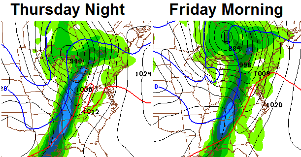
Winter comes fighting back in behind this front and there is an increasing signal for a rather harsh period of winter weather for the final week of February into early March. The pattern is likely to feature additional accumulating snows to go along with VERY cold shots of air.
Does this mean spring will be AWOL for all of March? The CFS March forecast certainly does not look very “springy”…

That shows a much colder than normal month across much of the country. Personally, I think the pattern breaks warm around the middle of the month.
Have a great day and take care.

It must be a bad feeling to be consistently 10-20 degrees off on temps.
Hopefully you aren’t referring to Mr. Bailey as he’s the most consistently accurate meteorologist in the state.
Everybody has been off on temps though some worse than others its just Maw nature
I wish cb would put a broader stmt out on temps rather than a general one like “it’s going to be seasonal temps in the 40s”; here in se ky we will hit 60s tues and wed and will flirt with 70 on thu. we are still part of KY last time I checked, unless we got took over by TN and didn’t know it 🙁
Sometimes i wonder if we had lol
I agree but it’s not only temps that is consistently off.
Both you and Beth are wrong.
I am ready for a warm up.But it looks as if we will be back in cold mode soon enough.Likely going to be cold or at least very cool throughout March.Its the low 20s here this morning but I suppose that is a big improvement compared to zero or below.This has been a very long, stressful and depressing winter.Thanks for hanging in for all this time giving us updates
18 deg here this morn! after yesterdays snow we have hit the 30 inch mark for snow this winter in my area! WOW! We have had snow on the ground for weeks!!!!!!!!!!!!
Please dont be a repeat of March 2013, where average highs were 10 degrees below normal. Im tired of just going to work and sitting in the house when I get home, because it’s too cold outside. Sunshine and warmth just makes for a better day. Don’t want a climate with six months of cold weather and that’s what this year has been.
Get used to it as it could be the norm for the next decade. Weather runs in cycles and we are heading into a cold one.
You are right about March of 2013 being cold. It was 2.3 degrees colder (on average in Lexington) than December of 2012. I am sure that hasn’t happened very often.
At least CB sees the pattern breaking the middle of the month. Last year it stayed cold all the way to the end. Anything in the low 50s was a good day even though average highs are 60 here in the southern part of the state. I guess we will just have to ride it out.
Thank you Chris for answering my question from yesterday evenings post about your thoughts on the March temperature outlook. Although someone kindly answered my question for you,and said anyone that could predict what the weather will do past a week must be dreaming. I guess they have not been following you closely, because you have been spot on when it comes to predicting a time frame as to when it would break warmer or colder. Thanks for your response and all you do. God bless…..
rember way back at the first of november when bailey was talking about how we havent had no sub -zero temps since the late 90s and said that we would see sub-zero temps sometime by the middle of winter.how many mets did you here say that they all were saying average winter with no big deal cold.do you reacken that was a lucky guess ?i believe that was what ruffled a lot of mets feathers when bailey called for all this sub-zero weather before winter even started.hehe he smoked them
all depends on what you call average. Before the mid 90’s nobody would have been calling this a “Brutal” winter
If winter ended today, this would be the 3rd coldest winter since 1979.
but it hasn’t
The rain tonight should start the meltdown here in frankfort, it will be strange not to see snow on the ground in a few days!