Good Monday afternoon. Rain is pushing into the state this afternoon and evening as a winter storm passes to our north. This is the beginning of a super active week of weather that can bring severe thunderstorms and snow our way.
Speaking of thunder… we may hear a rumble of thunder in some areas this afternoon and evening. Colder air will briefly filter in behind this system and I can even see a touch of snowflake action later tonight in the north and east.
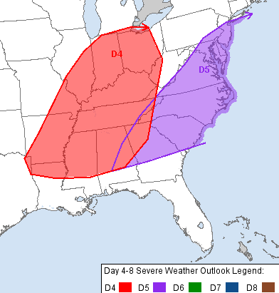
Temps begin to warm by the middle of the week ahead of a potent storm system works from the plains toward the Great Lakes. This will drag a strong cold front across the state and may lead to a line of strong and severe thunderstorms rolling in. The Storm Prediction Center has the entire state in the severe weather risk for Thursday…
 That setup may wind up being similar to the outbreak we had just before Christmas. Wind, wind and more wind may be the primary threat. Temps will drop some 30-40 degrees in a matter of a few hours and we may go from severe storms to snow during that time.
This will introduce winter back into the mix and we will likely have snow threats that follow for the final week of the month into early March.
Enjoy the rest of your day and take care.

Dodger says ride that weather like a thoroughbred! It’s the wild swings that can bring big snows! Dodger
Think I’m gonna change my plans for Thursday evening. Wednesday sounds much better. Thanks for the update.
WOW, the way it sounded last week we going to have a extended period of warmer weather, now that seems to be fading, frankfort is about one good snow away from 30 plus inches for the winter, sounds like me might get their!
I believe early last week Chris said to beware anyone talking of an extended warm up…like most other mets were doing at the time.
We might bust 12″ for the year and Andy might sadly bust 1.2″.
Compared to Frankfort- big fish, little fish, tiny fish. Andy might have got more than 1.2″ but the sense of scale is still there.
Hey Chris 🙂
Down here in the south we have 59* and sunny skies…was able to get outside and walk some today…I absolutely love this weather!!!!!!!
Thanks so much 🙂 🙂 🙂
That must be nice all Louisville could muster was 40 degrees and the rain has moved in not real sure the temps will get any higher in north central ky
Only got to 38 in NE Lou.
Currently 37…cold miserable rain.
Forecast high was 48? Oops
yep partly sunny and 56 here in London …… feels even warmer – I guess I am used to the bitter cold
Nashville TN went from 29 this morning 🙁 to the current 63 degrees 😛 . Love it!
There has been so much persistant cold wx that it didn’t occur to me until later that my work colleagues and I could have had lunch outside in our informal picnic area, although it has been a bit breezy.
38 in frankfort, ready for something warmer!
So glad I found out about Chris Bailey! Love your forecasts they are “spot on”. Looks like Old Man Winter just won’t back it in! He has been brutal this year!
oops typo meant “pack ” it in.
Temps pushing 60 here in Carrie of knott county nice sunshine out
What does AWOL mean in CB’s last post?
“Does this mean spring will be AWOL for all of March? The CFS March forecast certainly does not look very ‘springy’…”
It’s short for Absent WithOut Leave. A military term, here I believe it means ‘nowhere to be found’.
Thunder and lightning with a gully washer in L-metro. I apparently have ice in my gutters as they are overflowing all over the place.
NWS in Paducah not mentioning any snow behind the front Thurs/Fri and shows temps in the 50s on Friday. Should be interesting.
Thunder in Frankfort with some heavy rain moving in, strange to here thunder with lots of snow still hanging around!
My predicted high of 47 in Lex for today has busted! Already at 48 according to the mesonet.
I don’t see how a one degree difference is a “bust”. Anything four degrees or less is a pretty good forecast I think.
Thanks for the updates Chris.
Hope all this spring does not feature a bunch of these back and forth warm/cold. When these are strong enough you run the risk of severe. Like the tornado here that was followed by snow. Spring needs to come on strong and stick around. I will even bake some cookies and provide milk (I know Santa is not the only one who likes it). Come on spring.
Today was a nasty day in Central Kentucky. Didn’t get to 45 or so until the rain moved in–and now back down to 40. Still below average for the day. The warm-up has not impressed me thus far.
Still around 50 here in knott co at 930 pm
with severe and strong storms possible , it will be a good time to check to see if your weather radios are in proper working order, and on the correct frequency.
handheld radio is fully charged , and ready to relay any storm damage if any . im not a storm spotter, but a ham operator, that will relay messages net control if severe weather net is going .