Good Tuesday, folks. Today is shaping up to be one of the nicest weather days we’ve had across Kentucky since the fall. Many folks will want to get out and trade the cabin fever for a case of spring fever. This walk on the mild side may also produce some wild stuff later in the week. That’s when we will have to watch for the potential for strong or severe storms.
Let’s start with the good stuff and that’s the weather of today. Highs will hit the low and mid 50s for many areas under a partly sunny sky. Winds will be a little gusty, but nothing we can’t handle.
A fast moving disturbance will scoot across the state tonight and may bring a few showers in. This will knock the temps down a few degrees for Wednesday as the sunshine returns.
Thursday is when we have to keep a close eye on the evolution of a storm system in the plains. That will deepen and work toward the Great Lakes. Ahead of it, temps will surge into 60s on a gusty southwesterly wind that may top 35mph at times. Instability will increase throughout the day and that may help get a potent line of storms to develop to our west. That line would come racing eastward late in the day into Thursday night.
This could lead to a severe weather threat for a lot of people…
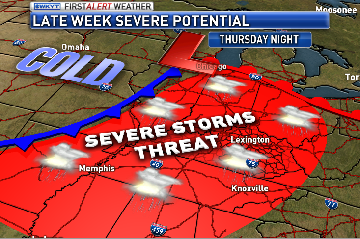 Damaging winds would be the main player with any line that sweeps eastward across our region. That is something to keep a close eye on.
The temps take a dive behind this boundary…
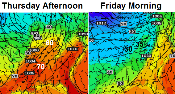 It’s possible for some areas to go from severe storms to snowflakes in just a couple of hours Friday morning.
The cold air then bleeds in over the coming weekend, but should really settle in next week. Check out a familiar look to the pattern…
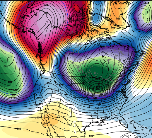
That is a very cold map that can lead to several snow threats next week into the first week of March. There is a decent signal for some kind of big winter storm in the eastern US during this time.
Take care.

Yesterdays 12z run of ECMWF (Euro) showed an arctic blast again with sub-zero temps as close as Indianapolis. Single digits and teens for us. Curious what this mornings 0z and this afternoons 12z will show. Winter time is running out, by the time you know it, BAM, its sunny and 70° out in a few weeks (hopefully)
I’ll take this–it is actually above freezing this morning in Lawrenceburg (barely at 33–but still, an improvement). Lexington’s temp yesterday ended up as “normal” on the 2nd day all month that did.
Going to be a nice couple days it seems. Can’t wait for squall lines to snow though. Severe weather season has got to be better than last year. I think we only had a few mean storms that moved through Lou metro last year.
that’s a good thing
Actual low temperatures above freezing? What a concept.
Once Spring fever hits this week and the first little flowers start to peek through the ground, it will be really hard to return to Winter. Can you folks on the Ohio River put up “Do Not Enter” signs at the border to keep the cold air away?
Sorry. Living in Cincy and working in NKY, spring and warmth can’t come soon enough! Let the thaw at least begin!
Today will be nice but I think some folks has forgot it got up to 60 in frankfort on February 1st and melted the snow we had at that time, then Feb 2nd snowstorm started this long stretch of cold and snow until today!
This morning i do my usual routine let my Rottweiler and my shih-tzu out they run outside as normal then i witness both of them completely slip and fall. I said to myself thats odd my thermometer read 35 degrees. So i put my slippers on start walking to the driveway and then I proceed to slip and fall. So then both my dogs ran over to me and in the process of them running over to me they slip and fall right on top of me nothing like a 110 lb Rottweiler landing on my stomach as my shih tzu licks my face. So I collect my myself gingerly shuffle back into my house with the dogs sit in the couch and say what the h*** is going on!?! Well come to find out as I turn on the news that Louisville county wide turned into a skating ring even though air temps were well above freezing ground temps were not!! So the rain we got with the melting of the snow and the clear sky’s and calm winds that developed caused black ice county wide. Parts of the Gene Snyder had to be shutdown in spots till the salt trucks were able to be dispersed. If someone had a video camera in Louisville probably could of won ten thousand dollars by just filming the slideoffs and fender benders and accidents on what not to do when driving on black ice.
Ten thousand dollars by submitting to America’s Funniest Video’s that is
Something seems so odd and unique this morning. Ground temps (and temps just above ground level) are still below freezing and there ice all over my lawn from last nights rain. Frost on cars and lawn, black ice all over the streets. How much weirder can it get?
Even when air temps were above freezing we still managed somehow to get a unexpected black ice event to unfold.
Very disrespectful on mother nature’s part completely took me my dogs and alot of other people off guard this morning.
words of wisdom from Kramer
http://www.youtube.com/watch?v=OLB2-RNv2w8
Cincinnati had black ice as well, along with all the rural areas where the snow pack has been place I am sure. Hope this is not evident tomorrow as well.
ahhhh … already sunny and 42 in London …. can we hit 60 today ? this weather will be just like the song by meat loaf “paradise by the dashboard lights”
It’s already mid to upper 40s here in knott co I’m gonna guess well into 60s today
Will need to watch upcoming storms. Temperature swings like the ones predicted to come could spin up a monster storm somewhere in the Midwestern or Eastern US.
The snow in my yard in frankfort is more like snowcone ice, it is taking a licking but keeps on sticking, sunshine should get rid of the sunny spot stuff but shaded areas doubtful its going anywhere until Thursdays 60s and thunderstorms!
already 51 here so 60s are a sure bet
Hard to believe this was the second coldest January on record here in West Virginia. 2nd only to 1977. We had an average temp of 24 degrees. I’m ready for spring