Good Tuesday afternoon. We have a hyper active weather pattern across the region and this is kicking into high gear this week. With a big temperature swing and a strong storm system on the way… severe thunderstorms are becoming more likely later in the week.
First off… let’s give it up to weather out there today. Enjoy it!
A fast moving system brings showers into the area later tonight into Wednesday morning. Temps will be down a few degrees on Wednesday as the sun moves back in by the afternoon hours.
Thursday into Thursday night is taking on the look of a severe weather outbreak across our region. A powerful storm cranks in the plains states and rides into the western Great Lakes. That drags a cold front across the state and we’re likely to see a damaging wind producing line of storms along it. A few tornadoes can’t be ruled out.
The Storm Prediction Center is hitting the threat pretty hard from 3 days out…
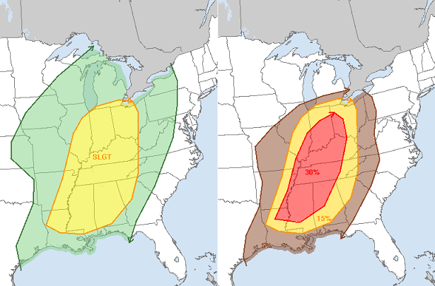
Non-thunderstorm winds may gust to 40mph as our storm cranks. With such a windy system, a soggy ground and weakened trees from the recent ice storm… we could be looking at issues from trees.
Colder air comes slamming in behind this, but we don’t really see it get cold until later in the weekend when a arctic front swings in. That may have a wave of low pressure along it Sunday morning…
 Again, winter is coming back next week and looks to hang around for the better part of March. Snow chances look common over the next few weeks.
Take care.

SO TIRED OF SNOW!! The END!
I can take the snow and cold better then severe weather I say keep the snow until May then go straight to fall keep those tornadoes away I know it’s just my dream…lol
My thoughts exactly!
No thanks I want warm weather.
This snow lover and his snow loving friend will be in Lexington through Sunday……..it might be our only hope for snow since it’s non existent in Bowling Green. Those tired of the snow can take it for the team right?
Sun feels great in frankfort, one good thing about going thru a extremely cold spell, it doesn’t have to get very warm to feel great!
Did Mother Nature think all the black ice would be funny today?? I had heard about the black ice but didn’t get out until 10am when it was already 45 degrees outside, so thought I wouldn’t have to worry about it. Wrong! Trying to get up the hill on the narrow country road in front of my house was a real effort, then it was time to slide down the other side. This was the slickest it has been all winter. Even the horses were moving slowly in the pasture today as the field had areas that were solid ice and very slick.
Thanks Chris. Thursday looks interesting to say the least. Hope the severe stuff fizzles out. As for more snow chances, I am nearly positive that southern KY will miss that too. We will get the cold though….and the cold rain. But today is absolutely gorgeous! Hope everyone gets a chance to get out and enjoy some of it. Have a great Tuesday, everyone!
The predicted high for today in Lexington is 53° by the NWS. It’s 52° and it’s only 1pm. Hoping we could keep warming up quick and try to make a shot at 60° today! That’d be nice.
Looks like we could be into a pretty stormy Thursday. Warmer than expected temps with a strong cold front. Going to be a windy rainy day. Enjoy these next two days as March could be a record cold month.
It was ten degrees below for avg high last year. If it’s colder than that I want no part of it. May have to head south until June.
Whats the opposite of the torch? We need to have a name for very cold weather and tell bryant it will not be a blowtorch march.
How about The Freezer?
Ice Gun
http://comicsroots.webs.com/mr.%20freeze%203.jpg
Looking at the NOAA 8-14 day outlook shows ky very cold but dry also, if its going to be cold might as well bring the snow, but will have to wait and see if the moisture hides from this next cold spell?
I agree wholeheartedly…if it has to be cold, it might as well snow. I hate dreary rainy days. At least with the snow, you have something pretty to look at and its peaceful!!! So I am with you Todd!!!
You used to be my favorite forecaster CB until you said that winter was hanging around most of March 😉 . Another year that winter just doesn’t want to leave when it’s supposed to. 🙁
As cold as last March was it wasn’t even a Top 10 coldest March in Lexington or Louisville. And in fact, it was 10 degrees warmer than the coldest March ever–1960. I didn’t enjoy it either–but it could have been worse! 🙂
“A few tornadoes can’t be ruled out.”
“It’s possible for some areas to go from severe storms to snowflakes in just a couple of hours Friday morning.”
Sadly, that sounds awful and familiar. Read that second quote. Then when I hit the first quote in the next update I actually had chills. Do not know why but I just feel really worried about this setup. Hope it comes to nothing much and everyone is safe.
Very interesting contrast again between CB and Lou. local MET’s…
MM on WLK just said he expected some strong storms on Thursday, but nothing severe. He definitely never brought up the T word or the trees being vulnerable.
He also downplayed any big arctic outbreak. The lowest high temp he had for Louisville through next Tuesday was 39 (almost 40). He also had temps in the low 50’s Sat. and upper 40’s Sunday. Not one mention of snow being a possibility.
All winter they have been late to the party, Chris always is best at seeing the cold before others slowly Nowcast as it gets closer!
And that surprises you how?
not a bit….just frustrating how meh so many of the MET’s seem to be in Louisville.
Good thing they don’t hire based purely on personality. 🙂
NOT liking your last two sentences, Chris. I’m okay with another winter blast that lasts a week, but not all of March! You are right way more often than not, but sorry, I hope you are dead wrong this time. 😉
been stuck at 59 for an hour in London; I feel like i’m at horseshoe casino waiting for 3 flaming 7s to line up!! come on 60
Maybe we’ll get snow again on St. Patrick’s Day this year. Wouldn’t that be something? 🙁
some of the the wet, large and amazing snows have happened in March…never count Winter down and out until, hummm…maybe July!
Dr. Forbes of TWC has central and western KY up to a 4 on his torcon scale for thursdays event, for those not familiar with this, it means a 40% chance of a tornado within 50 miles of that area, lets hope that doesn’t keep increasing!
WLKY is general seems to downplay everything. Even the great Belski isn’t the same since going there.
I was just saying the same thing to someone a few days ago about Belski.
We have all loved him for so long. But, I think it is Jay’s policy to have EVERYONE on the same page, which means HIS page, lol.
Belski doesn’t have free range to interpret the ever changing data, as he once did at Wave-3. I feel Brian Goode is a younger Belski over at Wave-3. I like him, and Lauren Jones the most at Wave, and I also like Lauren’s husband (Jude) at Fox-41, and Monte Webb over at Whas-11.
Chris Bailey is still #1, though!
Belski still has his blog. Brian Goode I like. He tries to keep us all informed on what may or may not happen with his video blogs. Jude Redfield is far superior to Marc Weinberg. Monte is alright.
Maybe west KY will FINALLY see some snow this season. We have mostly missed the January and February snows and it’s been more than frustrating 🙁 Have seen big late season snows in the past so we’ll see.
How do you know it’s been a COLD winter? When we get black ice because roads are colder than the air temperature. That was the case this morning!
I suggest u don’t get spring fever because there a OLD SCHOOL a comin before it is over! remember 1987????????????? yea that’s what im seeing something it that range….
Now Rolo I’m tired of waiting for that old school just keep it cold so we keep that severe weather away
I’d much rather have some warm weather so that it will be nice to go outside and enjoy nature again. And you can’t grow a garden in cold weather either.
Weeeeeeeeee!
Atleast frankfort has had one middle schooler, 6 inches at one time 😉
You better be twirling your fingers around your ears when doing that 😉
And in about 3 minutes…..sorry folks nothing to see here. Typical nonsense.
To me it’s not worth four more weeks of cold weather to get an old school storm. Now if it wanted to get here next week and warm up after I would be ok.
59 in Lawrenceburg after a low of 29. Most of the snow is gone–first time I’ve seen this much ground since early on February 2nd. The Versailles Road/New Circle interchange was actually shut down for a while this morning (around 7:00) due to black ice. I noticed a ton of salt on the ramp when I came through at 7:15, so it must have been slick in spots.
Chris Jackson is giving 50’s for fri and sat what’s going on with that
Dodger says Bailey out on a limb with snow predictions this weekend. No one else mentioning that. Dodger thinks Bailey kinda likes the view from that limb! 🙂
Duck Dodger say Dodger despicable.
Chris please tell me this is not a set up like we had march 2 2012
Not March 2. You never know what may happen though. That’s why you need to be always prepared for the worst.
Well, no one predicted this! Pretty healthy storm here in Versailles, complete with lightning & high winds. A medium-sized (30 ft) tree in the backyard came down, hope this isn’t a preview of Thursday. Bring back the snow!