Good Wednesday, everyone. Our active weather pattern rolls on as a weak system moves out early today, making room for a stronger one on Thursday. That will bring the chance for severe thunderstorms into the region. All of this will lead us back into a very wintry pattern for the rest of the month into early March.
Our early morning showers and thunderstorms will give way to afternoon sunshine as temps warm toward 50 in the north and low and mid 50s in the south.
The action starts on Thursday as winds begin to crank and temps surge. Gusts of 40mph will be possible during the day as thermometers hit the 60s. A 70 is possible if we get enough sunshine. That sunshine will also increase instability ahead of this powerhouse of a cold front…
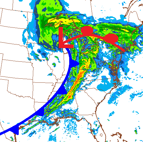
That squall line of thunderstorms racing eastward across the state will have the potential to produce damaging winds. Isolated tornadoes will also be possible.
As mentioned… a lot of our trees were damaged by the recent ice storm and our ground is thawing out and fairly soggy. That could mean an increased risk of damage from trees.
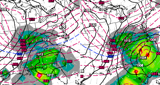
Colder air quickly filters in behind that front for Friday as skies clear. A arctic front arrives late this weekend and may produce some flakes before the weekend is over. This will set us up for a very wintry pattern and we will need to watch the Monday-Wednesday period for a potential winter storm across the eastern part of the country.
The European Model has been sniffing this out and does show it impacting the bluegrass state…
 You have a lot of winter left to go before true spring arrives. I will update the severe threat later today. Take care.

Good little thunderstorm here in Winchester at the moment, thundering, lightening and very windy.
Setting at 54 in Carrie this morning don’t have to warm much to get in the mid and upper 50s today
It was 35 here and a thunderstorm but wkyt was saying it was 54 silly weather….
The air has a “spring-like” feel this morning. 48 degrees in Lawrenceburg with some humidity thrown in.
I agree, 52° in Lex and a dew point of 50 certainly makes feel springy, almost summery.
Wow, I’ve never seen forecasted temps so far off. In Lex, the NWS forecasted low just 24 hours ago (yesterday morning) for today was 38° and it is 53°, does anyone know why so off? That’s gotta be one of the biggest busts I’ve seen. Shouldn’t we easily reach 60° today then? Even CB’s forecast of high to mid 50’s is busted/in jeapordy, because its in the upper 50’s in southern ky, at 7am!
All the mets have had a time with the warm sari this year, been several 15-20 degree temp busts down here in knott co
Air, darn typo
Computer models have been complete garbage with surface temps either been to warm or to cold.
Thanks, Chris. Boy what a way to get woke up this morning! A big clap of thunder that sounded like an explosion made me sit straight up in the bed about 4AM. It was so loud, it shook the whole house! The rain started then and I went back to sleep but that one was close!
I do not look forward to severe weather tomorrow. Hope that the sun stays hidden, as much as we all want to see it.
Chris, I know you will be keeping a close eye on everything, so I just want to say thank you in advance. Have a great Wednesday, everyone!
Forgot to say that we have partly cloudy skies this morning and the temp is already at 54 degrees.
the glacier finally has melted in frankfort, a couple little spots in shaded areas, a new one might start next week the way Chris is sounding??
The rain and storms last night turned the snow brown!!!!….oh wait…that’s the ground. It’s been so long since I’ve seen it I almost forgot what it looked like….
For anyone who cares, Dr. G has increased tomorrow’s TORCON to 4 for west and central KY. Again, that’s for anyone who cares.
TorCon still seems kinda low though, if it goes to a 5 or 6 then it would be time to worry, I agree with C.B. looks mainly like a straight line wind event!!
Think I’ll pop the tops on the Vette & cruise this afternoon, before I get my winter coat back out.
Congrats on the powerball win…
You’d be amazed what you can get a decent used ‘vette for, if that’s your thing.
Temp low 50s in frankfort but a howling wind is making today not all that nice, go away wind!
There were doppler radar indicated tornado warnings early this morning for a few counties in East Tennessee. I don’t think any tornadoes actually touched down though. It was ironic though because today is Tennessee’s tornado safety day and this whole week is Tennessee’s severe weather awareness week.