Good afternoon, everyone. Today is a typical late March day with gusty winds and pleasant temps. Tomorrow, we will hit the fast forward button toward late April with temps nearing 70 and the threat for severe thunderstorms.
The first item up for business will be the potential the another round of late night showers and thunderstorms rolling in. This action will be ahead of a warm front that swings northward across the state. The Hi Res NAM future radar for tomorrow morning…
Skies behind this warm front will clear up and temps will take off. We could hit 70 before the afternoon is through. Wind gusts of 40mph or higher will also be possible during the day.
As this is happening… an area of low pressure is deepening and working from the plains into the western Great Lakes. Instability is being drawn northward ahead of this storm and trailing cold front. That will help ignite rounds of strong and severe storms in western Kentucky during the afternoon. That action will likely congeal into a squall line that races eastward through the evening. Here’s the timing from the Hi Res NAM future radar…
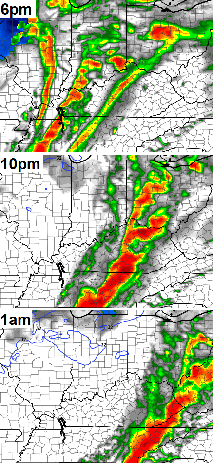
That bad boy looks to be rolling quickly eastward across Kentucky and is likely to contain damaging winds. A few tornado spin ups will also be possible.
I will have the latest on the severe weather threat on WKYT-TV starting at 4pm. I should also have another update coming your way this evening.
Take care.

Something tells me we are rapidly becoming the New Tornado Alley.
SPC updated Day 2 outlook
Slight Risk across most of the Commonwealth.
Hatched areas for I-65 corridor west – significant severe weather expected.
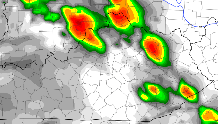
To expand the hatched area part of this. “Hatched area: 10% or greater probability of signigicant severe weather within 25 miles of a point (SPC). This is the SPC’s representation of the hatched area over the western half of Kentucky for this event.
The hatched area covers western KY and northwestern TN.
As CB touched on, strong damaging winds will be the threat with the highest risk.
If there is some good news, the tornado threat will be relatively low and isolated, as it looks at this time that there will be limited shear. Somwhat less of a large hail threat as well.
Not that we should let our guard down.
You all can keep Spring, and all the storms/tornado threats. I’ll keep winter and summer.
From NWS Jackson
A STRONG COLD FRONT WILL MOVE THROUGH KENTUCKY LATE IN THE DAY THURSDAY. THIS WILL LIKELY DEVELOP A LINE OF THUNDERSTORMS AS IT PROGRESSES EAST. A FEW OF THESE STORMS COULD BECOME SEVERE WITH DAMAGING WIND GUSTS AS THE MAIN THREAT. HOWEVER…THERE IS ALSO A SMALL RISK OF A TORNADO OR TWO WITH THIS LINE OF STORMS. THE PRIMARY THREAT FOR SEVERE WEATHER WILL BE FROM 7 PM THROUGH 2 AM ACROSS EAST KENTUCKY. THE STORMS WILL ALSO BRING BRIEF HEAVY RAINS THAT COULD LEAD TO HIGH WATER ISSUES…ESPECIALLY IN LOCATIONS THAT HAVE
RECENTLY LOST THEIR SNOW PACK. IN ADDITION TO THE SEVERE THREAT… GUSTY WINDS OUTSIDE OF ANY STORM…ARE EXPECTED THROUGH THE DAY THURSDAY AND DURING THE NIGHT. SOUTHWEST TO WEST WINDS WILL LIKELY GUST AS HIGH AS 40 MPH AT TIMES THURSDAY AND THURSDAY NIGHT. NOW IS
THE TIME TO PREPARE FOR THIS EARLY TASTE OF SPRING SEASON SEVERE WEATHER.
um…great…
I know people on here are not high on the WKYT weather app, but it keeps changing like every 2 hrs. Now not showing as cold, was showing snow on 2/25, but now sunny ???????
All weather apps are computer automated, including the WKYT app.
65 and sunny here in knott county, real day out
Better than fake! 🙂
Saturated ground + more rain + high winds = trees uprooting. Not good.
Thank you for keeping us informed. Looking like tomorrow night might be rough. Really do not like when this stuff comes through late as I like to be awake and will stay up. Guess I will be staying up late tomorrow.
Me too I do not like these kinds of storms.
Can someone PLEASE tell me what time this is supposed to start ? I am driving to ST. LOUIS tomorrow. What time is it supposed to hit central KY and how fast will this system be traveling approx ?
It appears to be close to the I-65 corridor around Lu-metro at or about 9:00 pm.
Thank you Ssssoooooooo much
NWS says not much happening next week cooler but no winter storms??
Is it me? Or does it seem like the Louisville mets are downplaying the severe weather for tomorrow? So,makes me think it will be worse than what they are saying. Usually they predict doom and gloom and nothing happens. This time they are being cautious so expect the worst.
Beautiful 70 degrees in Knoxville after severe thunderstorm warning and tornado warning this morning. Couldn’t ask for a more beautiful day. Hope this continues.
The sound of rain this morning was just wonderful. Spring is just around the corner.
I did not appreciate getting woke up at 3am another benefit of snow over storms is that snow is quieter. 😉
I have to admit this warmer weather is great, if this next cool down does not happen that would be great, come on spring, without the tornados though??