Good Wednesday evening. Thursday has all the makings of a very active weather day across the bluegrass state with high winds and severe thunderstorms. A Wind Advisory is already out for much of the state through early Friday as wind gusts will top out at greater than 40mph.
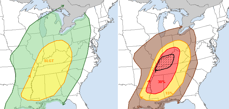
The latest update from the Storm Prediction Center continues with the slight risk, but shows an elevated severe weather potential for central and western Kentucky…
A squall line of thunderstorms will likely develop across western Kentucky and roll eastward during the evening hours. We will need to keep a close eye on the possibility of a few storms going up ahead of this line. That’s something the latest Hi-Res NAM simulated radar is showing tomorrow evening…
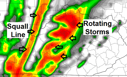
If those storms to go up ahead of the line… a few tornadoes would be possible. That is certainly not a given, but it’s something we will have to keep an eye on. Regardless… the squall line can produce damaging winds as it rolls to the east.
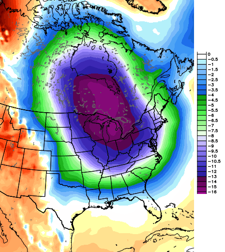
On a different note… winter is coming back and may come back in a big way. How about a late February and early March version of the Polar Vortex? That is being suggested by most of the medium range models and would mean a prolonged period of much colder than normal weather around here. Look at a 5 day average temperature departure in Celsius…
 Winter… Is… Not… Over!
Take care.

Thanks for the update Chris, I guess tomorrow is the main focus at the moment since it could get dangerous around KY, anything winter like I think we will handle just fine since, one more big early march thumping of snow and officially I’m done!
Thanks Chris. Hope severe weather stays away from everyone.
why do these things almost always come through here at night?!
thanks for the heads up, Chris. I will be prepared.
I was wondering the same thing.
Unfortunately, winter time severe t-storms/tornadoes are indeed relatively common at night in our area (click this NWS Paducah link) and this NOAA/NWS link for more info.
All the more reason for weather alert radios, wx alerts via internet, or other early warning systems (or a combination of these for redundancy) to use while you sleep.
Winter — I’m over you.
Thanks Chris, your very appreciated!
As long as the polar vortex comes with a ton of snow I’m all for it.
I 2nd that….
Agree, all though if it stays cold most of march that will lessen the chance for early blooming trees to get damage from to much warm to soon then damaging freezing weather later!
Go home winter, you’re drunk.
I wonder how many Severe Thunderstorm or Tornado Watches the Storm Prediction Center has had to issue thus far in 2014? Not many, if any I would guess. Looks like we will find out tomorrow!
Looks like 8 total from what I can gather, 7 were issued on Jan 11th, and the latest was Feb 12th.
I notice the night thing is more common too….
But it has happened during the day a few times. I distinctly remember how black the sky got to the west in the middle of the afternoon a few times from severe thunderstorms to the west or northwest. I had never seen a sky that black until I moved here..Creepy as ……….