Good Sunday, everyone. Before we start things out… let’s have a big round of applause for the weather we had on Saturday.
 The minion in the middle looks like me enjoying a rare day off. No… really, he does.
Things begin to change today as a strong cold front works across the state. This will set up one heck of a temperature gradient from north to south early in the afternoon. Temps may range from the 60s in the south to the 30s in the far north. The cold air quickly wins the battle as the cold front drops southward.
This front is likely to contain a band of light snow behind it this evening and overnight.

My sentiments exactly. This band of light snow will be more prominent across the north and east and COULD have just enough juice for a small accumulation. That will be something for us to watch on an hour by hour basis as the front swings through. Your regional radar should help you along…

Much colder air sweeps in behind this front as a familiar pattern takes hold. It’s one that will feature a blocking ridge across Alaska and the Polar Vortex displaced toward the northern tier of states…
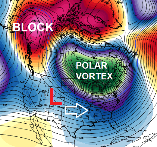
Areas of low pressure will be sliding in from the west. Some of these will be rather week, but a few will try to really ramp up. We will need to watch one arriving by the middle of the week and another coming next weekend.
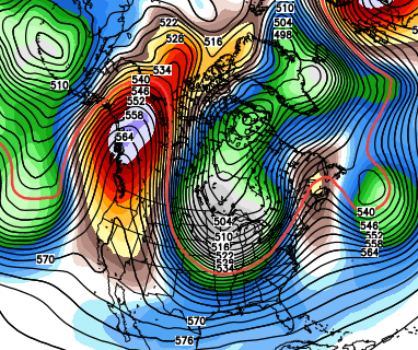
Looking a little farther down the road… check out the GFS Ensembles for March 19th…
If I could find another minion GIF to go with that, I would. Unfortunately, they are all G-rated. 🙂 If we don’t have some fun with this pattern, we may go crazy waiting for spring.
I will update things later today. Take care.

Thanks for the update Chris and that bottom minion hit it for me.
Thanks Chris for all you do. I am so dreading more cold weather. I’m ready for spring and getting the boat out and fishing . come on Spring!
I’m out on the March winter stuff….maybe a half day of winter after March 1st, but it’s way too strong sunshine to let winter grab hold…It’s over after this week til next year 😛
Not seeing much chance for decent snow. Since warm air during the main part of winter found a way to cut into snow, seems it will win out even easier and more common the closer to spring.
Bringeth Springeth.
Referring of course to the usual “neglected” areas.
Well I hoping the forecast had changed but I guess we are stuck with it.Been so stressed dealing with all the winter weather that I have spent most my time sleeping when we got a break.Missing out on the majority of the sunshine but I suppose I can look at it as getting ready for the next round.Thanks Chris.
lololol
Lowest level of maximum sunspot activity in centuries….inversion of earth’s magnetic field…we need more study of this. Last I read ytrue north had made it’s way to northern Greenland and some suggest this is first stage of complete mag reversal of planet which happens every 300k years or so and is 300k overdue.
One silver lining–the colder weather tends to minimize severe weather chances. Looks like it might be a quieter March for severe weather than it is sometimes.
As it was last year, due to the unusually cool weather pattern.
I was hoping with the cold winter that March would turn out better. Last year the winter was kind of mild, so I thought the cold March was just averaging things out. Guess not, since this year it has been cold all winter. Hating this forecast. Wasn’t hoping for a blow torch March, just wanting average and looks well below two years in a row. Blahhh.
I’m about to consider starting an advocacy group to ban Canadian exports to the US. They can keep that nonsense – over it.
Thanks Chris. Lol
There is one instance above where I believe “weak” should be used instead of “week”. Love the minions!
Nice post Chris…..I am as giddy as the upper minion about the chances for more snow. Winter runs until March 20th, let winter have its time. After that bring on spring and then summer. Fishing and swimming sound really nice.
I do agree. Seems people complained about winter not happening way before the actual start to winter and now the same is happening with spring. Enjoy the seasons.
I would just settle for average. Not being greedy and wanting 70s and sun everyday. Average high temps for southern KY this time of year is 50+ degrees. I would be more than happy with that. Just don’t want 30s all the time in a month that is supposed to be 50s. I enjoy going outside for a walk, washing the vehicles, working in the landscape etc… Much more comfortable if we could at least get close to average.
It’s funny that we can’t get a credible forecast for 7 days out, yet looking at March 19 GFS. NOBODY knows what the weather is going to do 4 weeks from now. I wound bet a shiny new dime it is warmer in late March than late February though. Lol. Some stretch huh?
Last year the average high temp in March was 0.7 degrees higher than February. Not hoping for a repeat.
The models on the GFS and Euro are trending colder and bring back more/multiple shots of cold and snow. Both even are showing us….. gulp… going below zero, IN MARCH! That is extremely unlikely but the fact that a models shows it in March tells you the potential this pattern has. I was reading the forecast discussion NWS Duluth, MN and they were saying the coldest airma-ss across the whole northern hemisphere and probably the entire world (because its summer down there) will be coming through central/southern Canada and could come to the US bringing record breaking cold in late Feb/ March.
The minion on the left looks like Jim Caldwell, the middle one Chris, the one on the right Micah. 😉
What happens on March 19th?
Winter officially ends 🙂
Funny I was looking at the radar And soon as the moisture reaches the Ohio River it turns to rain.
An absolutely beautiful day here in Perry Co.——temps in the ’60’s and not a cloud in the sky……yet! I’m gonna’ go out and soak up the sunshine while I’m getting in some firewood to prepare for the coming cold weather.
Chris that is such a cute post.I love the graphics. 62 here a beautiful day.Back to the Race.
Anyone in the area actually have snow reaching the ground?
Chris, you made my day by adding those minions to your update. Very funny!