Good Monday to one and all. Winter came back with a vengeance last night with a band of snow that was the heaviest I’ve seen in forever. This is part of the master weather plan that Old Man Winter has for the region as we roll through the rest of the month and into March.
Temps today will run from the mid and upper 30s in the north to the 40-45 degree range in the west and south. Skies will be partly sunny.
After today… This becomes a pattern loaded with energy cutting from west to east to our south. Severe possible snow makers will be on the menu over the next few weeks. The first one arrives later Tuesday into early Wednesday…
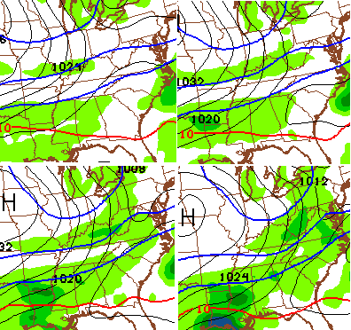 That would be a decent round of snow that could cause travel issues by Wednesday morning. Maybe some snow days? Check out those cold temps coming in behind the snow. Readings Wednesday may not get out of the low 20s for highs.
The next system may bring a round of snow our way by Friday with a more important system possible over the weekend and into early next week. Things could get very interesting before all is said and done.
If you want a depressing look of the pattern ahead, take a look at the CFS temperature anomaly forecast for the next 45 days…
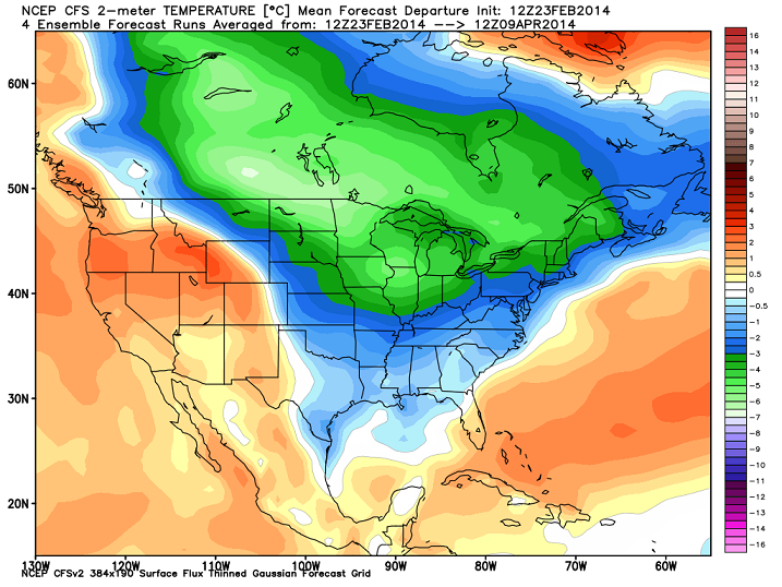
Two things about that map… the numbers are in Celsius and it goes through April 9TH! That’s right… I said APRIL 9TH. As I said… it’s the winter that just won’t stop!
Enjoy the day and take care.

I think I am going to stop reading the blog until mid May lol too depressing. I am ready for thunderstorms! No one hurt or property damaged before I get jumped for liking severe weather lol 🙂
Not meaning anything toward you chelle because I know you don’t want anyone hurt or anything like that but the tornado that hit west liberty in 2012 has make me scared to death of a thunderstorm if you ever have to see what a tornado can do you will never want to ever see a thunderstorm I had always see damages of a tornado on TV or something but seeing it first hand I can’t tell you how helpless it makes u feel to see your town totally wipe out with then a few minute is just unbelievable I only knew 2 of the 7 people that lost there lives that day it’s a nightmare I don’t ever want to go through again…..
They are terrible and nothing you can do.I saw the one that hit East Bernstadt hanging in the sky as it went to the north of my house that day.Don’t think I have ever seen a sky so black.Hoping it wouldn’t come on down but a few minutes later I heard sirens and as the news came out it got worse and worse.My neighbor lost two family members in that one.The devastation from a tornado is just unbelievable.
Yea it didn’t hit where I live we here it behind our house but seeing what those things can do is just unbelievable it took our whole town
I understand you fear and respect of tornados but on a positive note it is very unlikely the same area will be hit again by a major tornado anytime soon, in frankfort the last bad one hit in April 1974, yes it can happen but odds are against any one area getting hit mutiple times in this part of the world!
Not in Moore, Oklahoma. They’ve been hit in 1998, 1999, 2003, 2010 and 2013. Probably moore tornadoes have hit in previous years, but can’t find much info. Other than Oklahoma, its EXTREMELY rare to get hit more than once outside of central tornado alley.
Yep, my point exactly, lots of people are scarred by the 2012 storm, but frankfort is a larger city in area than most of the towns that got hit that year and it has been 40 years since this area has been hit! maybe a couple small F0 isolated storms but nothing major since 74!
Did a quick check.
True, Kentucky had about two dozen tornadoes that wild day of April 3 1974. Including almost a dozen F4s like the one at Frankfort. Including the infamous F5 at Brandenburg, which was bad even for an F5. Again, all this in only one day.
But after April 3 1974, Kentucky did not record another F4 until 1992. No F5s/EF5s have happened in KY before or after 1974. This of course doesn’t mean we can let our guard down. But we can have a little comfort on how relatively rare the stronger tornadoes are for our area.
I am so sorry for what you had to go through and your loss. I grew up in Texas, so I know all about it 🙁
Chelle I know that night will stay with me forever just seeing how so many people lost everything they had and the lives that was lost I will never forget that feeling the days that follow seeing everything gone and I can’t watch the video that they have of that tornado because it’s still so fresh in my mind our town gone people stuff everywhere personal stuff in trees u know that tornado didn’t take my home but you don’t have to lose stuff for it to really effect you
Overall I guess it isn’t to bad.I am trying to remind myself of those hot summer days when its pushing 100 and how much I would enjoy this cool weather during those times.
Seems like we are either roasting or freezing half to death anymore.Rarely just a nice day with no heat nor AC needed.
Thanks Chris.
I know I’m in the minority, but I don’t mind it. Winter is my favorite season and as far as I’m concerned, it can be Winter until Fall rolls back around. I dread Summer and the heat it brings. I’ll take 10 degrees for a high any day of the week over 100 degrees with 95% humidity…
“Welcome to Summer in Louisville, where the air’s so thick you can chew it!”
I know, I know… If I don’t like the heat and humidity, I should move somewhere else. If packing up my entire life and relocating were that easy, I’d do it.
I totally agree with everything in this post.
Same here.
I hate the summer hot and humidity too…….but I hate the extreme cold too. I like 30s at night and 50s during the day. That’s perfect……
I want spring, but really don’t want storms. Chris Bailey, I have to confess something. I DVR’d your winter forecast back on November 20th just because I wanted go back and look at it. I am amazed again. It is spot on. As you know I have been a fan since you started at WKYT so long ago. I also just want to thank you and the WKYT weather team for keeping us up to the minute on severe storms. I spent most of the night in my basement last Thursday with you on the tv. Again Thank you.
Yea this weather dude knows his stuff….
I’ve got to move south when I retire. I like a few snows, but don’t like winter hangin on for an extra month or two. I would just take average which is 50 degrees right now. I’m tired of being in the house. It’s just work and back in the house. Would much rather have it work, maybe a walk outside in decent weather, and then to the house. Lol
not really buying in on this winter extension …. for London the average temp for March is around 57/58, forecasts for the first two weeks of March are temps averaging 51 …….. a sunny day in the 50s is still spring feeling days; you don’t want to jump from 30/40s to 70/80s … not good on trees, soil, vegetables ….
Hate to tell you this Jim rather your buying into or not temps will be well below average for a pretty long stretch thats pretty much a given. As much as i hate saying it you might as well get use to it.
well if the normal is 58 for my area, but it only gets to 52, wow I can live with that – I was saying I was buying in on the winter staying around … I sure hope people don’t take what cb says to be gospel …. nobody, and I mean nobody can get weather right around here past 7 days, and good lord he’s been so far on temps it’s comical. BTW if/when the gulf jet stream decides to kick into high gear then we will have extremely warm temps in KY, and it could happen anytime ……..
Let it snow, let it snow, let it snow. It has been mentioned here before. Some of our biggest snows have came in March. They just might stick around longer than a day with the colder temps that are being forecast.
Thanks for the update CB. Looking forward to March.
True, but for a lot of us, that can now be rounded to two decades since it has happened. Heck, a large area of the state still has not got past a few inch event, yet alone a big event. Well, unless ice of course.
Seems just cookie cut the winter so far and the ones before it- The areas of the state that got snow will have a shot and the ones that do not… not so much.
BubbaG up until this year I felt your pain. Snowless winters are as bad a cool summers when you have a pool and like the water temps in the high 80’s to low 90’s. Winters are not what they used to be here in Ky and large snow events middle and late March are not real trend busters. May the force be with you and 2015 bring a winter to remember. If you can stand to wait that long.
Didn’t get any flakes here in knott co
NWS starting to align with CB’s thinking about Tuesday night, as well as the upcoming weekend. As my 7 year old says, “If it won’t snow 10 inches, then it should be 80 degrees.”
March of 2008 saw a 14-16″ snowfall (with blizzard warnings!) in Northern Kentucky, so its not been that long for us at least. I think it also nailed Louisville but can’t remember.
We are sitting somewhere around 44″ of snow for this winter up in this part of the state, its been pretty awesome if you are a snow and winter lover like me. LOL I did enjoy losing the icy glaciers last week though, that was getting old and dangerous to walk on. We of course still have big piles of snow remaining at the edge of parking lots that never totally melted.
It’s amazing what a difference a One hour drive up I-75 has on snow totals, Frankfort has about 20 inches less than your area, but the starved folks in southeast ky are sitting with just a few inches?
And stranger yet, Knoxville has 11.9 inches so far this snow year while even Chattanooga has 8.4.
Go figure.
You’re right, Kris…March ’08, we here in Bardstown got around a foot (give or take) of heavy wet snow. I have pix of me & the new Keeshond puppy I’d gotten for Valentine’s Day out in it, along w/ our Border Terrier! If I remember correctly, I think we got that big one on the weekend of March 8th or somewhere in there, and I don’t think they were predicting it to be that much, at least around HERE?! Think most came during the day on Sat., because I have pic’s of little fat Keesha trying to plow her way thru the backyard and all you can see is her little curled-up “piggy-tail” she had @ the time!
I was about to graduate from WKU in March 2008. That was one of the few good snows Bowling Green ever got while I was a WKU student.
But this was also shortly after the Feb 2008 “Super Tuesday” tornado outbreak inwhich KY and TN were hard hit, including just southeast of Bowling Green.
I also graduated from WKU in 2008 and I drove up to Louisville while we it was snowing. It was during our spring break.
My part of Richmond has had 10 to 12 inches of snow this year total. Largest single snowfall I have seen in my 9 years though, 6 entire inches at once, did occur this winter. Lexington and F’frt has had about double that amount. Crazy. Even worse is south central KY with almost none. Crazier…
Next time I yell “Blowtorch,” someone smack me. Please.
LOL 🙂
You even said blowtorch will come in March 100%, so far (at least the first week or so of March) looks very cold.
You have to be the biggest jinx on here in history (next to Rolo), for the weather lovers.
Basically, Bryant is to Spring, as Rolo is to Winter.
Congrats! 🙂
You said at the time that you were following some other folks who were saying Blowtorch warmth for January. If I were those other folks, I’d be studying up because they’re missing some weather mojo.
You need to come on here prognosticating record cold and snow.
Nice day out today sun and 40 feels good to me
I first thought the 45 thing was a typo. I thought surely he meant 4-5 days. Then I scrolled down. If the Barren River region doesn’t get a good snow soon and everyone north and south of us does…. I’m really gonna cry. I want one good 6 to 8 inch snow. Can you do anything about that?
You could rent a snow maker and place it on the roof of your house. Alah…instant snow….
January was the 4th hottest January on record for planet earth….
On mans calendar anyway?
“On record”
True Todd, but what else can we go by? The science that they use to determine Earth’s historical climate could be used. It does show a lot of very warm and very cold periods. But, that same science seems to point at this current situation being very uncharacteristic in many ways.
Why do we need to go by anything, lets just say the world globally is in a warmer period, lets not try to predict what happens down the road when we clearly don’t have a clue! Models can’t tell me what it is going to do next week much less in the years to come?
Next Sun – Mon Night will be very interesting to watch the models over the next several days. Wundermap/Weatherundergound extended forecast for LaGrange Ky is Sun 40% chance of snow…Sun Night periods of snow 3-5 inches Low 24…….Monday Periods of snow 5-8 inches 34 degrees….Monday Night Snow 1-3 inches low 16…..WOW wouldn’t that be a dream come true….
funny, for London, the same site has Sunday cloudy 49 and Monday, rain and 52
This will be one of them Fence storms…Areas near the Ohio River North will see the rain/snow line. Areas south of the river mainly rain with warmer temps. Seems to be a strong system so we will have a northwest movemet. All of Ky and Southern In will be rain. Snow further north into Indiana is my current thought. GFS precip has most of Ky with 1-2 inches Sun-Mon Night.
I hope you’re right, actually. I’m tired of these fence situations that threaten to turn into ice storms. Seems central KY has been on the rain/snow line for most of the storms this winter.
With Richmond being mainly the rain line 😉
Not an altogether bad day for late February. Sunny, temps approaching 40 in Lexington (high should top out 38-40). That’s only (8-10 degrees below normal). Looks like four chances for snow the next 7 days–carrying us through the first few days of March. At least it is something to track.
Marc Weinberg on the 4pm news said this weekend is definately something to watch.
OLD SCHOOL is coming before MARCH is over… anybody remember 1987 in SE KY??? YEA I THOUGHT SO..
The Rolo that cried “old school” LOL
Don’t discourage! If no Rolo, some of us have nothing but the usual misses. The Rolocoaster is better than no ride at all. Sleigh riding is not exactly a common event for ankle biters and rain areas like us 😉 Might as well ride the Rolocoaster. Weeeeeeeeeee!
not for Ky you will change your mind as always
I do, Spring Break. Had a soccer tournament in Pigeon Forge and it was canceled due to 2+ feet of snow, Gatlinburg was closed due to 3 feet of snow. That was late March early April!!
I had to go north in Lex early this morning, so I decided to look for some of what this “heaviest snow band even seen by CB” left behind. Someone must have been hiding it very well a it wasn’t anywhere that I could see around the I-75 corridor.
Sleet and rain in Berea last night, but zero snowflakes.
My husband heard from a reliable weather source that there might be a “chance” of ice this weekend. Nooooooo! We already have school until June 10th!!