Good Tuesday everyone. The weather continues to be all about three things… winter, winter and… winter. Light snow will be sweeping across the state later tonight and will usher in some very cold air into the region. That cold will hang tough well into March and is likely to be joined by additional rounds of snow.
Today will start with some snowflakes flying across parts of northern Kentucky. We could even see some minor accumulations for a few spots. Skies will become partly sunny for much of the day with highs in the 30s. Clouds will quickly scoot in later this afternoon into the evening.
Our band of light snow will streak from west to east and should be able to put down light accumulations. This will generally be an inch or less for many areas, but eastern Kentucky could see a bit more. Regional radar will show whatever is out there…

Temps coming in behind the light snow will be VERY cold. Readings by Wednesday morning will range from the high single digits to low teens. Gusty winds will make it feel colder than that. Check out the Wind Chill numbers from the GFS for tomorrow morning…
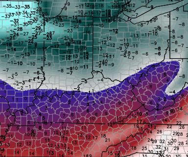
That’s right… below zero wind chill temperatures are very possible for several areas. Highs tomorrow will struggle to get out of the low 20s.
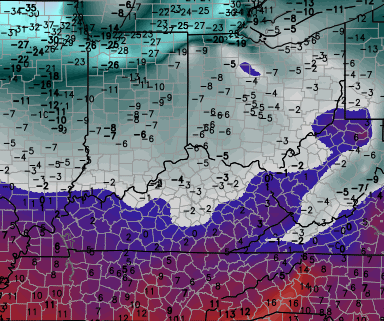
Another shot of cold arrives Thursday night and may send temps back into the single digits by Friday morning. Wind chill numbers are forecast to be even colder…
 This will lead us into another light snow chance for Friday night and early Saturday. A bigger storm will likely follow that up by late in the weekend into early next week. This is one that can bring some nasty stuff to much of our region.
I will have another update later today. Take care.

Nasty stuff as in ice? (Seeing as to how I don’t view 10 inches of snow as nasty)
Exactly, describing something as “nasty stuff” isn’t helpful in the least. If this system has an ice potential then clearly state it. I’m not really understanding the reasoning behind being purposely vague.
Sometimes MET word usage seems biased and thus misleading. A hot sunny day isn’t always gorgeous and a cold winter day isnt always nasty.It is my biggest annoyance with weather coverage. I like a ten inch snowfall. It falls under gorgeous for me, not nasty. The same with every type of weather actually. It is all gorgeous, except for high humidity. A hot and humid summer is just uncomfortable and thus the word nasty might be more appropriate there.
He is not being purposely vague. A discerning mind knows this.
Sunday/Monday storm likely to be mainly liquid.
Frozen liquid
Beau also said its too far out to call 🙂
If your in SE KY its never to far out to call all liquid 😉
We are both in WKY
I think SE ky will see a good period of accumulating snow. Intensification over the mountains is certain.
Congrats on your acceptance letter..I’m sure you will make a outstanding MET..
Thanks!
Yes, it’s very far off to say exactly what type of precip the late weekend storm will be. But as of now, about all signs point to just plain rain with some back side freezing rain and snow. Storms almost always trend north, that’s why I think Central and South KY would be ok. But don’t hold on to my word as I could be completely wrong.
I agree on that. Especially the stronger lows that phase. Ohio river north snow/sleet…Ohio river south plain rain….I am still holding out on the bubba buster……or ROLO old school storm. Here in Lou we have received our quota of snow for the season. Would love to see more!
In Louisville im thinking if it snows another inch Louisville will be in the top 20 snowiest winters. That looks real achievable with the system tonight and Friday night. If it doesn’t happen tonight I think Louisville will get that on Friday.
I am thinking another 3 to 4 inches for most since 77-78…Now we are talking. Heck lets just go all in and say we get another 12-20 before March is over. All time snowiest…It is Possible!!!!
SnowGloater! Boo! 🙂
so it is safe to say that saying winter will stick around till April 9th is too far also — comparing apples to apples
I think its safe to say that winter will hang around till at the very least mid March if not most of March. Thats not to say we wont have some nice days thrown in here and there. On average March looks to average below normal temp wise. That doesnt mean with every system were talking snow gotta take into consideration the average high temp now is 51 and by the end of March average high temp upper 50’s and if temps are 10 to 15 degrees below normal your still looking at a cold rain more than you are wintery precip.
33 in knott county this morning
Thanks, Chris. Speaking as someone from the snow starved southern part of KY, I wish we could get a big snow. I mean, if its gonna be cold, might as well be snowing, right? Either way, time will tell. as for the overnight and tomorrow morning snow chances, we will likely get that, since it is calling for an inch or less. those are usually a given for us. 😉
Thanks for all you do Chris. I hope everyone gets to go out and enjoy today. Have a great Tuesday, everyone!
On this Sunday/Monday storm somebody is going to get blasted. There looks to be a tight temp gradient from temps possibly near 60 to temps ranging in the lower 30’s from north to south. Key thing is how far the cold front sags into the commonwealth and where it stalls out and the actual track of the low. The southern jet will get involved so there will be gulf moisture with this storm. To many scenarios that can play out. Could be all rain for KY to snow freezing rain sleet and plain rain depending on where your at. Gut feeling would be southern and central Indiana/Ohio extreme northern KY could as of now being looking at a real legitimate shot of a nasty ice storm. With accumulating snow on the northern edge. General rule of thumb usually not always these sort of systems trend north cant really see why this system would be any different as of now.
The temp gradiant on the current GFS is something else. Looks likes peeps along and north of the OHIO River will get the brunt of the Wintery Precip. NorthWest shift WILL happen. Hope that the cold air is stronger and more east before this storm hits. Something to watch. Seems most mets around the country are going torwards a more cold March for the Midwest. Just doesn’t break down below the river.
As usual the I-64 corridor will more than likely be the battle ground if the storm trends further south than my thought process.Im still thinking the battleground will be further north but wouldn’t shock me the least bit if it was the I-64 corridor.
Tim Hedrick in Cincinnati is saying it may start off as accumulating snow Sunday night, and end as rain. He also said this forecast is so far out, that it could easily change.
Last thing look for the models to be fighting with each other on what will happen the mets might not get a good handle on this storm till Saturday evening/Sunday morning.
I’m SO tired of the cold weather! I can’t wait until summer so that I can complain about it being too hot! 🙂
This little snow tonight just looks like a salt maker for the roads, south of I-64 looks to have a chance at 1 inch. Lexington probably is in this zone tonight! Deck duster probably most areas!
Ready for spring, tired of toe biters!
So, you have 22-24 inches of snow this year, and you are still complaining?
If it’s all rain. I’m fine with that. If it’s snow. I’m fine with that too. Sleet is cool. Just no ice storm please 🙂 I just wish this winter would be over because I feel like it’s lasted an entire year. It’s crawling by. I hope the summer is cool though. That would be nice.
Give me upper 70’s low 80’s with low humidity I’ll be a happy camper wishful thinking I know
Last summer was very wet and cooler, so I expect hotter and dryer this summer!
OLD SCHOOL 1987 COMING!!! get jur POPCORN READY!!!!
Now that is what I am talking about….It is in the air. Someone within 100 miles of central ky is going to get OLD SCHOOL…
Same ole rolo bringing false hopes and let downs 😉
I have a different word for it, but children read this blog. 😉
It is interesting to see the temperature difference in Bowling Green and Louisville and Lexington. It is almost like South-Central Kentucky is in a totally different climate zone than North-Central Kentucky.
Weekend system looking like rain statewide with temps in the 40s and 50s, frozen stuff will be in Indiana, Ohio!
what a SURPRIZE right!
Todd you cant go by just one model run its going to change 15,000 times between now and Saturday night
The trend of the winter would say this will be rain when the larger storms come our way, would have to do something different from the trends to be a large snow in central KY! But we shall see I guess?
I think we know the answer already 😉 Just as long as the ice stays away, I am good with rain. For people perhaps wishing for ice instead, you are real sick and need a hug.
Watch for common words: Mix, rain, sharp cut-off, verga, WAA, Taco Tuesday. You know the drill.
Can someone tell me when you talk about I 64 corridor what area that is? Yes I know dumb question but I truly do not know what that means as far as where that is….If I knew then I might would understand more when I read Chris’s blog and the rest of your all’s posts. Thanks in advance!!!
Draw a line from St. Louis to Huntington WV and you have the I64 Corridor…Hope this helps!!!!
Would that include Ashland KY?
Doesn’t I-64 go right through Ashland?
I64 is not more than 15 minutes from where I live.
I64 path?! I would never have thought that! 😉 🙂
For snow lovers, a heart felt 🙁
WWAdvisory
A QUICK MOVING BOUNDARY WILL MOVE ACROSS EASTERN KY TONIGHT…WITH COLDER ARCTIC AIR USHERING INTO THE REGION. THIS WILL PRODUCE A QUICK HIT OF ONE TO THREE INCHES OF SNOW IN MOST PLACES. WITH TEMPERATURES EXPECTED TO DROP INTO THE TEENS AND LOW 20S ACROSS THE
ADVISORY AREA…SNOW WILL STICK TO ANY UNTREATED SURFACES…AND POTENTIALLY TO TREATED SURFACES AS WELL
Never fear, people that do not want snow! Come to the protector from snow and stay in Berea or Richmond! For shear spectacle, watch on the Richmond side of the Kentucky river as it snows on the other side, yet nary a flake on the south side.
Hey, even CB has backed it up with snow accumulation & radar maps- It’s science! 🙂 😉
I will back Bubba up on that…
The Louisville office is just calling for around 1 inch, didn’t realize that was enough for a WWA?
We usually get a NSA: No Snow Advisory
🙂
Lookout Bubba this Sunday, now I’m hearing that dreaded ICE word!
If the ice rain line is Lex/Rich, we get the rain. if the Snow/Ice line is Lex/Rich. We get the ice, but rarely the snow line side.
Yeah, I was kind of wondering that too. Pavement temps are pretty high so I don’t think we’ll have to worry about snow sticking that much to the roads. I can see a special weather statement being issued for this but a winter weather advisory?
I believe the air temp is supposed to around 20 when the snow is falling so whatever falls will stick pretty much on contact–I think the advisory is more for the impact on the morning commute than actual snow totals.
Maybe Overachiever tonight, NWS Jackson has some spots getting 2-4 in eastern KY?
I need about 8 inches for the rest of the snow season to reach 30 here for the first time since 1995-1996. An inch or two tonight, and one good storm in March and there it is. I hope Jackson is onto something.
Frankfort is at about 22-24 inches for the winter depending which backyard your in, but that would something to reach 30 inches or better!
Not quite sure of the reasoning behind a WWA, even for the morning commute. Whatever happened to Travel Advisories that used to be issued for nuisance level snows?
I’d not encourage anyone to get “excited” about the late weekend storm. Despite the cold high to the north, it will go north and 99% of KY will get rain. Sorry, I’m in western Kentucky and we’ve missed more snow this winter than Dale Jr. has fans. Tired of the flopping models and ready for spring!
I wouldn’t downplay it just yey.
OLD SCHOOL coming before MARCH is over!!! remember 1987?????
Yes ROLO! You have said this 1 million times already lol. I hope your right, (I dont think so)
1998 is the last time frankfort had a double digit snowfall at one time, 16 years, now that’s old school!
I remember the last time you said that and the next day said nothing to see here
The boy who cried old school.
Weeeeeeeeeeeee!
My students have enjoyed getting outside these last 2 days. I told them that the next few days will be TOO cold! Let’s just hope we don’t miss any more days of school.
Anybody have any guesses on delays or cancellations on school tomorrow in northeastern KY?
Seems like the forecast tonight in the advisory areas have been built not to bust with all the dusting to 2 inch chatter, big impact spread 2 inches vs a dusting!
That is called auto pilot 😉