Good evening, folks. Another round of light snow is on the way to the bluegrass state tonight and could cause some travel issues. I’m not expecting a lot of snow, but what falls will likely be enough for some cancellations and delays Wednesday morning.
Here’s a breakdown:
– Light snow develops late this evening and ramps up into the wee hours of the morning. This will zip across the region and be pushing out of eastern Ky shortly after daybreak.
– With the expected cold temps… roads may become slick and even snow covered for a time. A Winter Weather Advisory is out for much of central and eastern Kentucky tonight…

– Snowfall totals won’t be that impressive, but an inch or two will be possible for some with locally higher amounts in the east…

– Speaking of the cold… temps by morning will hit the high single digits in the north and mid teens in the south. Gusty winds will give us wind chill readings below zero for the northern half of the state and single digits in the south.
– The rest of your Wednesday looks good, but it will be COLD. Highs will range from 20-25 degrees with wind chill numbers in the single digits at times.
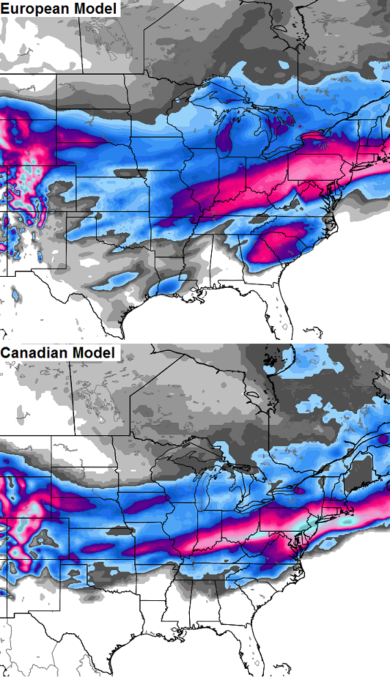
If we look at the next 10 days, we find a couple of the more reliable models putting the worst of the winter weather right on top of our region…
The winter that keeps on keepin’ on!
Take care.

This winter is like the Energizer Bunny!
WWAs all around us and we are still being left out. So for us it’s the winter that never got started. Everyone be careful tonight and in the morning. Have a great evening.
WWA just means the roads will be salty for us Coffeelady
No need to even waste the salt on this round. Haven said that, no salt or other pre-treatment has been applied to roads here.
Looks like the extreme southern parts of Laurel County gets left out once again! According to the future map’s, if correct, looks like Somerset, Barboursville, London, Keavy, and Corbin is all going to go without snow again. So yeah I agree, this has been one wimpy winter! The winter that has not arrived!
Holy potential! But probably, like always, will not pan out. What we do need to watch is that snow in Georgia! That is another possible winter storm AFTER the Sun/Mon storm. If so, that baby could strengthen and move North and West in our favor across TN valley into KY.
Radar looks to be slowly filling in to the west and heading straight for central and eastern KY, Lets hope for a old fashion overchiever?
Yea, I’m up for a few a inches.
Don’t be distracted by the big area of of snow over Kentucky on the EURO – check out the bit around South Carolina… That’s our eye candy!
That’s what I’m thinking also, that could trend north and west in our favor. But that’s IF that storm even forms after the sun/mon one.
Yup!
That would be funny if it wasn’t true. Oh well it’s still funny haha
With tonight’s action, Lexington will only need one more good storm to make this the snowiest season since 1995-1996. Louisville would have the snowiest since 1977-1978. Covington has similar numbers. Kentucky hasn’t born the brunt of this winter (that has been reserved for the Upper Midwest) but I-64 has sure been the dividing line. I sit very close to I-64 and have had much more snow than folks 20-30 miles south of me.
Well…. Richmond and southern adjacent areas are on the verge of the wimpiest snow totals for multiple years in recorded history! I made that up, but probably not too far off for being accurate. Such is the curse of the south side of the fence.
With all the snow to the north, only 1.4 inches here in Nashville (normal average about 10 inches a year). Less than an inch in Memphis (yearly average about 5). As others have mentioned, areas around Somerset and London KY have have had very little snow as well.
Yet strangely the snow picks up as you go even further south and east. Knoxville (11.9 inches so far for the snow season), Chattanooga (8.4), Huntsville (5.2), Birmingham (5.1) and Atlanta (5 inches even) are all above normal for snow.
Lexington had officially 27 inches in 2010. It’s the ninth snowiest winter all time. 1909 is tenth. So you’d be break some records if what your saying panned out.
And 2010-2011 was the snowiest winter in lexington since 1978
That’s winter from Dec.-March 1st
Well, that’s what I’ve always been “witchy” about, Chris….I live in Bardstown, and I KNOW for fact (it’s all you hear??!) is ppl in the Ville area a-gripin’ & a-moanin’ & a-groanin’ about how “WE NEVER GET ANY SNOW HERE???!”……(put the little baby-ish, whiney voice into effect…) And…it’s like I’ve said here before, like anyone paid attention….?! In Dec. ’04, while everyone within about 17 miles+ to the North/NE of me got a foot of SNOW…?!…We down here had to put up with a freakin’ ICE STORM! I could go on, but I digress….. I mean, sure, we have had SOME “toe-biter’s”, as I like to call them, in recent years (counting this winter, thus far…) but looks like the Ville/S. IN. are the big winners this year, yet again, even if they don’t think so?! Wanna bet y’all get snow this coming Sun/Mon storm, and WE get ICE??! 😉
Yes I”ll take that bet all day long. Louisville will not get snow as a matter of fact I think most of ky will get rain to be quite honest. The Sunday/Monday storm will be a doozy for southern and central Indiana and Ohio. I really think that most of KY gets away in good shape.
I said that earlier this afternoon that KY will be all rain this weekend and was quickly told that I should not jump on the latest model runs!
TRENDS of the big ticket items in KY this winter has been mostly rain, extreme northern ky has done well with these storms but 90% of KY has not with the stronger lows pulling warm air north!
Todd, not jumping on any model runs models will be jumping back and forth all week long. To me getting late into the winter season longer days higher sun angle I just don’t believe the Euro or Canadian as of now.
I don’t believe the Euro is all snow for Kentucky. From what I’ve heard, the Euro model accumulation maps count any frozen precip as snow (including freezing rain and sleet). Just today Lville’s Brian Goode mentioned on his video that the latest Euro run put a lot of Kentucky in the ice zone.
One good thing about the expected cold wx the next few weeks is that it could delay the start of the spring severe wx season a bit.
But when spring finally does arrive, there are some predictions for a rather active severe wx season.
With this in mind, there are some upcoming SkyWarn courses being offered for storm spotters. For example, if you are in or near western Kentucky, NWS Paducah has Skywarn courses scheduled for March 1 in Evansville IN and March 4 in Mayfield KY.
http://www.crh.noaa.gov/pah/?n=spottertraining
NWS offices in Nashville, Louisville, Morristown TN, Jackson KY and Wilmington OH also have upcoming Skywarn courses, both traditional and online. Check out their websites for more details.
Not good to be in the sweet spot this early. Going to be all rain south of Ohio River and sleet freezing rain and snow to the north. Although it is really interesting to have these systems roll through this late in winter.
atmosphere is saturated…
starting to snow in Louisville.
Surprised CB didn’t put up his traffic cams. 🙂
You know how crazy that’d be if that Euro model run were to pan out? how about a foot of snow from Lexington and temps approaching -10 degrees! That would easily set all-time March records. The lowest temp in March ever recorded in Lex was -2 twice in 1960. Hey, I’m just a messenger/interpreter and in no way am I saying that will happen. Odds are definitely against it.
Snowing in frankfort at a decent rate 🙂 overachiever??
I’m so over winter!
March 20th is officially spring, so enjoy your snow Barb!
All is good!
We will complain about the heat soon enough!
So am I! I hope there is not another flake falls in all of Kentucky after tonight. Northern half of the state has had their share and the folks who haven’t had a decent snow this year aren’t gonna get it anyway. 11″ here and I’m satisfied with that. Bring Spring!
looks like a BIG PART of the forcasted area will miss out on the snow tonite as it set up north of most..
Story of our lives this winter
I thought the snows were intensfying over our area and sinking southward?
Dodger is seeing a little snow tonight! He loves driving in it! Hoping for more snow Sun/Mon. Dodger!