Good Wednesday, everyone. We have had a heck of a winter across the bluegrass state and it shows no signs of letting up as we roll into March. We have the several shots of winter weather coming at us over the next few weeks. My worry is one or two of these shots develops into a full blown storm. One of those could come Sunday into Monday.
Let’s start with where we are now…
A quick-hitting band of light snow is rolling through the state early this morning and will be to our east shortly after sunup. This will leave behind some slick travel, so slow down and take it easy. It’s the temps taking center stage with readings hitting the high single digits and low teens to start the day for some. Gusty winds will knock the feel like temps down to 0 or below at times.
Afternoon highs will stay in the 20s under mainly sunny skies. Those same winds will make it feel even colder.
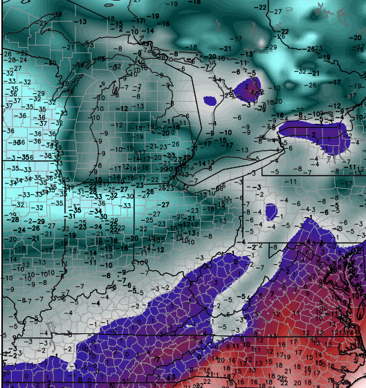
Another reinforcing shot of cold blows into town late Thursday and this could take several thermometers into the single digits for the final day of February. Check out the wind chill forecast for Friday morning…

That will be followed by a quick shot of light snow that tries to roll into town by Friday evening…
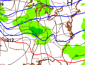
That can lay down some light accumulations into Saturday morning. The storm that comes behind this one continues to get my attention. While the likely track of this storm is yet to be determined, the pattern argues for it to go just to our east. If that happens, it puts Kentucky in a zone of some nasty wintry weather.
Guess what follows that up? Another blast of arctic air that can give us additional below zero wind chills…
 Welcome to March!
Enjoy the day and take care.

Great job as always!
I think I’m just going to go back into hibernation for a few more weeks. Somebody wake me up when it gets warmer.
Sounds like us that like snow need to be rooting for the Euro. NWS in Louisville mentions if it was correct we would see significant snow. Of course they are going with the GFS which brings a mix or rain. Just something to watch in the next 5 days.
Well I am okay with these temps and even if a little bit of snow comes I won’t mind.I don’t do well in heat so a choice of the cooler temps or the 90s and I will take this any day.What I didn’t care for was the single digit temps for what seemed like forever and endless days below freezing.Will be nice if the winds don’t blow to much today.
If you prefer 20s over 90s that is extreme.
The snow is coming down in Pikeville.Chris as always you were right on the money.
Deck duster in knott co
I think this .5″ smackdown gets us past 12″ for the winter. Winning!
1-2″ forecasted, received only 1/2″ also here in Berea. This puts us at 12″ exactly but that includes all the way back to the first snow accumulation in October. Several times Richmond has received slightly more than Berea, so over the winter I’d say this would put you at least 1 to 2″ above us.
Actual vs. forecasted percentage drops to 37.3% for the season.
“some slick travel” Under sold it for once.
http://www.twitter.com/lexwrecks
this puts us at 31 inches for the winter here in Flatwoods in Greenup Co! We have missed 13 days this winter so far and that is a lot for our city school (Russell Ind). we are on a 2 hr delay today hoping we don’t miss any more they have already taken 3 days of our spring break to help make up the days we have missed. I Love snow but I am ready for Spring Break!!!!!
not so much as a flurry
Andy we got a flurry in London …. I think it was flurry, although I did hear ducks flying over, so it might not have been snow 🙁
spoke to Chas in London she said roads are starting to cover
nothing on mine near town, buses still going full blast, laurel co hasn’t delayed or called school off.
If there is anyone out there looking at the models and thinking Ky is going to get snow Sun/Mon the you all have NOT been following the trends this winter. Every BIG storm that has come out of the south has shown most of Ky in the sweet spot 5-7 days out. Up until a couple days before to that matter. Once it arrives in the upper air network it always shifts to the North and west only to bring Ky cold rain. Unless this is a freak of nature storm, Ky will see just the same.
Cold Kentucky Rain. I am still holding out hope for a west side apps low that bring all of Ky an Old School, Bubba Buster, Trend Busting snow storm.
Preach it
“Cold Kentucky Rain” sounds like a great name for a bourbon, as well as “Bubba Buster”
London is forecasted Sunday to get 60 degree and thunderstorms and what really chaps me is this was never mentioned only thing that wants to get talked about it is winter and snow …. a met from Knoxville mentioned it last night about sun-mon being stormy in SE KY ….. it gets old being left out in state you live in.
Bjenks, I agree with your statement to a point. Yesterday I was thinking the same as you but there is something I was overlooking that the models seem as of now to be catching on to. With each front that moves on in one today and another Friday night what looks to be happening is its actually pushing the track of the low for the weekend further and further south. If you remember a couple of weeks ago with the storm that hit Alabama Georgia and moved up into the Carolinas the only reason why that storm stay south was because of the strong artic high we had over on top of us. The fronts that were getting now are not nearly as strong but strong enough to possibly keep the actual track of the low more to the south. To be quite honest if this does come to fruition I really dont think were looking at a major snow event but more a major icing event for parts of KY. Im still skeptical but I see this being a big rain event for some and a big ice event for other’s.
Very good points to ponder! The earlier season storms had the southeast ridge in place kicking lows north to the lakes. Winter in March is nothing like the winter in Jan early Feb. Atmosphere going through changes throwing arctic air on top of that change is not good. Icing is a good bet for much of Ky if this low stays south. I am still holding out on the trends and say the fence lies somewhere along the Ohio River.
I agree the battleground looks to be the Ohio River wouldn’t be surprised either way to see wintery precip maybe from as far south as Hardin Co and points north or to see the wintery precip never get south of the I-64 corridors either way whoever gets the wintery precip especially the freezing rain aspect looks to get one heck of a ice storm.
May have got .5 of an inch here in knott co
Same here snowed all around knox co. Ready for springtime!
Got about 2 inches here outside of charleston. Still snowing at a good clip. Schools are closed and roads are pretty slick
Not even a flurry in Middlesboro.
Thanks Chris. It snowed here this morning for about 5-6 minutes and the deck got covered and the ground was getting white in spots. And then we saw blue skies. Cloudy again now with some snow flying at the moment. I had to laugh when I saw the snow map last night. Winter weather advisories all around Pulaski County. I can’t figure out how it can do that and miss us every time. Talk about a dome! 😉 ah well, whatever it does will be alright. There is always next winter for us in the southern part of the state. Have a great Wednesday everyone!
Forecasts for Sun/Mon are trending colder for central KY. That doesn’t bode well. 🙁
This time yesterday, Accuweather was calling for rain Sunday through Monday night with temperatures well above freezing (were calling for 60 on Monday). Now they’re calling for rain with highs in the mid-upper 40s and lows around or below freezing. Weather Underground’s forecasts have decreased similarly and they’re now calling for a wintry mix with nighttime temps well below freezing.
You just wait, central Kentucky is going to get nailed with another ice storm.
No!!!!!!!!!!!!!!!!!!!!
I think parts of Kentucky will see a ice storm.
Looks like all rain for seky, no thanks on ice
I’ve never seen it take this many little snowfalls to add up to Lexington’s official winter total of 19.3 inches. I’ve had about 22 in Lawrenceburg. On Wave3 last night Brian Goode said that the winter weather advisory was the 17th of the winter for the Louisville metro! 17 systems equals 22 inches of snow! Now that is some ankle biting at its best.
Less than a half inch in east frankfort last night, another round of salt and toe nail biters are very old now, go big ole man winter or go home please, atleast until next December!
here is my silver lining moment for this ankle biter. there is not 2 inches of ICE under this dusting! I think Lexington needs to do an average snowfall for the county. there is no way the same amount has fallen at the airport than what we have had at Clays Ferry. not even close.
Couple of things…
I’m getting some reports from friends in the Lexington area of major disruptions on the streets and roads in the area due to last night’s snow.
For this weekend’s event, interesting takes from the local mets up here in Cincy. One guy last night thought it would be rain on Sunday followed by a mix Monday morning. His colleague this morning, looking at the same models but newer data said everything but “ice storm” for Sunday. Obviously these are NOT forecasts at this point and it is worth keeping an eye on.
Where you from Shawon? I’m from Cincy. I know John Gumm, local12, is saying it is definitely one to watch and looks to be nasty. That was this morning. Which stations do you watch?
Cincinnati looks prime as of now for a significant ice storm.
Say it isn’t so! Anything but ice.
Has anyone done an analysis on the frequency of significant ice events in KY? Growing up in central KY, I don’t remember any ice storms as a kid. I remember plenty of snow days but I don’t remember any winter storms where trees were destroyed and power was knocked out. You’d occasionally see ice storm footage in the news but they were always in another state somewhere.
First ice storm I remember was when I was in the mid-90s when I was a student at UK. Since then, it seems we’ve had a significant ice event every couple years. A few of which have been doozies (2003 comes to mind).
Have ice storms in KY (and central KY in particular) become more frequent in the last 20 years?
Wow Jimmie you put a twist on what BubbaG, myself and a few others here have been saying for a couple years. Ky has not had old school snows over the last 15 to 20 years. Plenty of opportunities only that come in the way of rain or freezing rain. Also plenty of ankle biters. Very few storms that dump 4-6 inch amounts. Higher totals only during freak storms. I hope we can get a freak storm over the next few weeks. I
A dusting to maybe .25″ here in Mercer Co. These crazy cold temps are sooo depressing. Praying this is the last hit we’re going to get and my pipes don’t bust again. I’m a snow lover but can do without the sub-zero temps. If this is the new norm for KY I’m moving.
Snowing again in Clay County! Big flakes!!!
Just watched a weather channel winter weather specialist show a computer model with this weekend storm tracking the low through Tennessee but it still had most of KY as just cold rain, really, I thought that was the perfect track for heavy snow here??
It is thats why I absolutely refuse to watch twc. TWC needs to concentrate and focus more on weather than what reality stupid show they will be signing in the future corporate America at its best. MTV use to be all music video’s now its all reality shows same with VH-1 & CMT. TWC is just a weather channel version of reality tv irrelevant garbage.
Certainly worth watching what may happen later on..Euro last night rather bullish for a lot of snow except SE Ky..Ice is the word for today..
Weatherunderground is saying rain, sleet, freezing rain Sunday and Sunday night. All snow with 3-5″ on Monday. This is for NKY.
I’ll take rain or snow. I do not want any more ice.
Sun sure got more power this time of year, even with the cold most snow has disappeared
Yep, only shady spots will keep toe biters around this time of year, sun is getting stronger every day now!
So tired of snow & cold. Would be fine with me to never see another flake of snow.