Good Wednesday evening. Here’s hoping you guys are enjoying the clear and cold weather we have out there right now. The cold weather continues to be dominant and shows no signs of letting up as we roll into March. The “winter’s over” bunch will keep telling you there is nothing to see here. They’ve been saying it since November… Why would they stop now? 😉
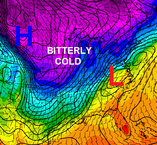
Around here, we make it about the weather and how it may impact you. The next system that may have a big impact on this region comes Sunday into Monday. This potential winter storm may bring snow, ice and rain to the bluegrass state during this time. It’s a rather potent setup with arctic cold temps diving in from the northwest as low pressure passes just to our south and east.
The GFS and European Models aren’t too far apart with where the low tracks by Monday morning…
GFS
European Model…
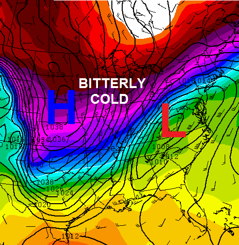 A blast of bitterly cold air will follow that up for the middle of next week and could deliver one heck of a shot of cold air for the heart of winter, let alone March.
Yep… nothing to see here. 😉
Take care.

Noticed the snow and ice have a friend on board now as rain rears its head. This is the norm for the “big” systems in ky….as they get closer it usually becomes more of a rain event due to the “dome” effect, I guess. Temps usually come in warmer than forecast, again, the “dome” effect. Long way out, but think this one drops the ball and becomes more rain than winter precip.
Ok, so explain this dome please. Something aliens brought in from outer space and put over Kentucky just to p**s you guys off each winter by keeping frozen water from falling from the sky? lol
Space aliens is as good an explanation as any for this meteorological fact known as the dome. By the way do insets tba little irritability in your post?
Do I detect a little irritability
I’m actually from eastern KY, but do follow the “dome” conspiracy theory.
Thanks Chris! We have not gotten much snow, but please no ice!
Thanks Chris, looks like we should be ready for everything including the Kitchen sink.
Thanks Chris. Sounds like I need to keep my long johns ready! Would wish for snow if we manage to get frozen precip in southern KY out of this, but the wY our winter has been it will probably be a cold rain. Only time will tell. But I can guarantee we will get the cold! ;). Have a great evening, all. Thanks again Chris.
I’m offering up a pair of flipflops and a fruity drink, with a little umbrella in it, on the sacrificial alter, in hopes of appeasing the goddess of spring, so she will banish this winter weather till November. Who’s with me?
Count me in…!
I’m with you Lori.
Coming soon to a blog near you.
Very curious to see what the models will say a few days from now. Anyone that says the models are completely worthless, doesn’t know the complexity of our atmosphere. Without the models, forget a 2 day forecast, let alone 7 days. No, the models are not perfect, and there are times where they bust BIG TIME. Without models, we would only be able to make a forecast 1 day out, if at all. Models shouldn’t be used as a forecast, but as tool to make a forecast. Many people think it’s easy to make a forecast by just looking at the sky and not use any technology. Models are terrible with these types of systems, they’re very sensitive temperature-wise, but it’s a BIG leap in the advancement of technology to even know this system will come at all than the “dusting of (whatever, I forgot.)” That came by complete surprise, now n’ days, that would’ve been on the models for several days.
1998. and i agree. this gives us a heads up that something is on its way. and to be weather aware. i know that the hubs and i will be getting more wood together for next week. and if the system is all rain? then we will have it prepared for the next one.
I disagree with you. The infamous dusting storm was actually a rain to freezing rain to snow with a dusting. John Belski was looking over the data (paper graphs) that the NWS provided. Showed a nice little ice storm to little or no snow. He checked out at around Six in the evening with that forecast. At around 1230 that night he received a call from the station that it was pouring snow in Louisville and headed back to work. This was preceeded by some of the coldest weather Louisville has ever had. They new a few days in advance that a storm was coming. Even without models.
That was 1994 wasnt it?
We really dont need anymore winter rains around here
The usually forecasted combination of the models put Laurel County and points east and south in a lovely cold rain. Well, let’s just get this over with.
I’m done with winter. I’m hoping this one tracks further north and west than the models are predicting. I’ve already had enough tree damage this year from ice.
If ice storms are going to become the new winter norm around here I think it might make sense to move to a house with no mature trees. Cooling bills might be higher in the summer but at least I won’t cringe each time I see a model run that predicts a rain/freeze line draped across the area.
These forecast models use CURRENT and PAST data to make predictions. It’s really that simple, they’re just plugging and chugging. Why do they always change? Because the current data is always changing, therefore, past data is always accumulating.
Think of it this way. Things like aircraft, vehicles on a highway, and even the flap of bird’s wings effect and change the weather. There is NO WAY for those things to be calculated and plugged into a formula. That’s why there is so much inconsistency from day to day.
We should look at these forecast computer images with less attention to specific details… Basically what I’m saying.
Yes, but there appears to be no regressive correction of models for when they bust quite regularly as far as outlooks, and a lot of times even the day of the event for snow chances.
Why is there no review of the very frequent outlook model misses and modifications of the models over time?
I feel for CB. He makes the best out of the stuff he gets, but the models are HORRIBLE for snow estimates.
Not much direction on the said event, which likely means CB is not sure about things and could fall as anything. What happened to the light snow for Fri/Sat? No mention now.
Just showed it on air. 😉
🙂
Why did the temp go UP 1 degree in the last hour??
We sure miss you in Putnam County,WV!! Thanks for still including us.