Good afternoon, everyone. I continue to focus on the late weekend and early next week winter storm potential. A messy mix of snow, freezing rain, sleet and rain continue to be likely across the state from Sunday into Monday. This may result in significant accumulations of ice and snow for some areas.
Here’s my first look at the areas with the greatest threat of seeing an extended period of winter weather…
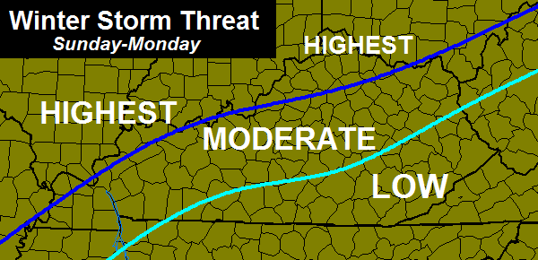
This is still 3 days away and a lot can change as we get closer. I will be updating this potential on WKYT-TV starting at 4pm.
Until then… think rain and take care. #teamrain

This should have been the winter forecast ;). Nice to see the consistency at least ya know what to expect
Have generator, fear NO ICE
Amen Brother…I laugh in the face of a good ice storm..But unfortunately i”m in the low risk area..Maybe the GFS will continue to go SE..Do like a good ice maker..
Reverse psychology???
the theme of winter for us being in the low risk area
#teamsnow…and lots of it!
#teamice..and lots of it..A little more SE please..
http://meteocentre.com/models/get_accum.php?mod=gemglb&run=00&type=ZR&hi=000&hf=120&lang=en&map=na
Good stay north.
But wish no bad luck to any
I am not happy with this. #noice
I can’t access that map at work, it’s blocked bc of the word “models”
seriously?
THINK RAIN!!!
Earlier in the season I used that for a little reverse psychology!
I hear you Chris! I know deep down you want this to be in the all frozen veriety.
Can’t help but “think rain” down here in my neck of the woods but it’ll sure be interesting for folks up a bit north.
smart money Mr Ryan
For me winter can go till the middle of March. Even when it starts to warm up in late march and April it’s not like your going swimming at the lake or anything like that. Until then a true winter lover says bring on the snow.
My better half (wife) is a snow lover/skier, but Nashville has received less than two inches snow this winter. While I like warm wx, even I would not mind one nice snow – but no ice – since we have had little snow here, and for my wife’s sake.
They say marriage is about compromise 😉 .
Not looking forward to a Ice storm chance, hopefully warm air hangs tough and keeps most of us in rain, several inches of snow would be great but that seems less likely with this type of setup!
Chris, I see where you have a long weekend and are hoping for rain. I have a suggestion head for the Hunt/Chas area of WV. This area has been the king of the 35 degree heavy rainstorms this Winter. And this is looking like more of the same. By the way we would love to have you back.
IN LIKE A LION OUT LIKE A LAMB
Thats what I want to see here in E KY
This appears to be a perfect track for major snow storm for Louisville. This is track we always root for but all we can get is freezing rain. So frustrating. We better hope we get sleet, fr rain, and snow because that may be only thing that prevents full out ice storm
Or heavy rain!!
Think Rain!!!
Unfortunately, I don’t think Louisville will get all rain.
Load the salt.
Seems ice is way more likely to be the main player.
The main player for me Sat/Sun looks to be all snow. Will be in Indianapolis until Sun afternoon/evening. Should be a very interesting ride home.
Thanks Chris. Once again it looks like southern Ky is in for a cold rain event. You folks that are sick of snow can come down here. Our good snow chances are about like trying to build an igloo on the sun! ;). That being said, I wish NO ice on anyone. Have a great afternoon everyone.
Setup has been same all winter! South of KY river -rain, maybe a little ice, ohio river -snow, maybe some ice.
I wish somehow it would drop south bring all ky snow!
In this case, probably a good thing.
Well well well…looks like The Euro has went more south following the trend of the GFS..Big Big snow for half of Ky…Maybe that’s put me in the ice age..Bring it on..
That half of the state does that include west liberty?
Just by looking at the snow map looks like west liberty is right on the line for over a foot or 5 inches..This is starting to get real interesting..
Readyforsnow what does it look like for Corydon IN i know you can’t be exact but i am trying to decide if we should break out the generator.
Don’t think i would worry the more north you are for Freezing rain..Probably all snow..However it should be monitored closely since were still 3-4 days out..
As Chris has stated, lots can change in 3 days, model runs in KY that favor large amounts of snow are usually fools gold!
Yep..Lot’s can change but so far things are changing in our favor..
We are do for a shift in our favor!
Thanks I don’t want ice snow great but no ice please
Plain rain, not freezing rain, would be fine with me!
Things will change as we get closer, but right now, all the local Ville met’s are pointing towards the ice/snow going from Ohio River NORTH, everyone else getting rain…Does anyone else here think that our Wx forecasting tactics in recent years have deteriorated, for lack of a better term??! No offense to CB-I still think he’s fantastic, along w/ a cpl others, but it just seems that, yrs. ago, they could predict storms a few days out, NOW, it’s more of a “wait & see”/”Now-Casting” type thing…in other words, just wait until that day, get your butt outta bed, look out the window/door every 30 minutes!??!
Winter storms in KY seem to be carbon copies, agree with everything you said!
Well, Todd…I’ve lived in Bardstown/Nelson Co. all my life….in ’04, we got the ICE, while everyone about 12 miles+ to the North got all of a foot or more of snow….no power,(came on just in time to cook the big Bird for x-mas dinner!) ,no cable for about 12 days….In March ’08, I think around the 8th or so(not sure??!) we got a heavy wet 10-12″…(I got pictures of me and our Border Terrier & new Keeshond puppy in it!) one weekend….’09, we were slammed, but didn’t lose elec…cable sux around here, apparently!!!? LOL! (Main Cable TV line & elec ran right behind out house then…I’ve since moved..no trees around!!! YAY!) (But I DID manage to break my collarbone during that mess….after the ice melted, our yard was a muddy mess, no thanks to my dogs, and I slipped on mud…ugggghhhh!!)
I am beginning to feel like Bubba….we have had a few “toe/ankle-biters” here this year, but nothing I wanna get orgasmic about…..I will take an ice storm….(believe it or not, I’m that weird!)
The Canadian model shows freezing rain into Nashville..A little over 1/2 inch and keeps moving eastward from yesterday’s run’s….Now i Know everyone don’t like the Z word but will gladly take what you don’t want..Hopefully winter goes out with a big explosion..
What is the Z word and can you post the maps please?
Can’t post maps..If i knew how to crop out the source i would..Most people refer to freezing rain ZR..
gotcha thank you for the explanation.
Explosion as in power transformers no thanks 😉
wow, more heavy snow for northern Kentucky, including the Louisville area. Who would have thought that?
Doubtful Louisville gets heavy snow, maybe ICE!
Covington probably will get heavy snow, they have only got 45 inches this year so they need more 😉
ANNNNDDDD…If I hear one more person from the Ville whine & moan and say “We NEVER get any SNOW??!!!”- I will personally hunt them down with a sharp icicle….
how about Barbourville i’m sure me and Bobt will whine some and maybe moan
Unfortunately you’re probaby right.
Two more inches and we break the record from the winter of ’77-’78!
Sadly it might be ice that gets you there.
Surprised the louisville peeps not barking about the lastest Euro run..A weenie run for sure..As someone famous once said..”Give me ice or give me nothing”..Ka Boom..
Having internet issues all day stupid att uverse anyways whats the latest Euro saying?
Be thankful you don’t have windstream. They can do fulfill their contract to cable companies that leach off their lines but they can’t serve their customers. I feel your pain on a afternoon-midnight basis
Perhaps I can post Spring cold/snow stats beginning March 1 to those who say “this is the coldest winter ever.” Well, compared to 2012 and 2013, I agree. However, the records say the coldest and snowiest winter since 2011! Perception is not always reality.
I really appreciate your devotion to keeping us informed. I do not want any more winter. I am thinking rain along with you!
Until the trend is broke I bet the farm that seky gets rain with a lil back end winter stuff at most. How bout those temps today around 40 here in knott co. Models have had a time with temps
Guess I’ll be grocery shopping on Saturday. We are definitely looking into alternative heat sources over the summer!
18z NAM looks to join in the fun with sleet and freezing rain.
Here’s the latest Euro if anyone’s interested..Found on another site..
http://i.imgur.com/YQ97z2W.jpg
Now don’t go jumping off bridges or do anything foolish..Sure it will change..
Thats not happening. Thats a garbage run by the Euro and not realistic.
I hope it doesnt get too bad in louisville!
High temps busted on the high side of the forecast today. Both WKYT and the NWS had upper 20’s for Lexington. Official high was 35! I’d like to see someone explain why such an extreme difference?
And no blaming the thermometer at BG airport. Even the mesonet sight had Lexington into the 30’s.
And this a bad thing why?
If you routinely follow the temp forecasts for the coming day, you’ll notice large disparities (e.g. +/- 6 degrees min) more often than you’d think. I’ve asked directly a couple of times for an explanation but haven’t found one yet. The odd thing is that it happens for both warmer and colder air, but usually limited to the Oct to March window.
Me some there had 38 I hit 40 30 was given for a high. Curious to see tomorrow, giving mid 30 a I look for 40s here in knott co
Mesonet darn smart phone
Low dew points. The drier the air, the easier it is to warm up. The air is drier than expected, therefore bringing warmer temps than expected. Air is REALLY dry, that’s why a SWS was issued for elevated wildfire risk. Dew point is -2°F in Lexington! Widespread 20% humidities across KY.
Why didn’t the models and forecasts pick up on the low dewpoints? I’m wondering how the models can be so far off in a 12-hour period??
why pick on today there have been many days that everybody busted on temps this winter
I had not seen a 7 degree difference all winter. I was surprised by that one.
i have seen several 7+ degree differences
Yep, feb 1st it was suppose to be mid 30s in frankfort, ended up near 60!
Some were even calling for 20’s! 30-40° bust! Probably the biggest bust I have ever seen.
18z GFS is just not budging if anything takes the wintery precip further south giving most of KY a significant winter storm. Im surprised to see the models not flip flopping nearly as much as I thought they would by now.
The warmer air will push in and it will be a rain event. Models won’t pick this up like the big bust of a few Fridays ago. WSW turned into a soggy day. But I’ll take rain or 10+ inches of snow. No ice please.
I hope it sits tight or moves farther north….that keeps my area out of any ice potential.