Good Thursday evening. As we get closer to the weekend, it’s full steam ahead toward a winter storm impacting the bluegrass state. The prime time for the nasty potential looks to be Sunday night into Monday.
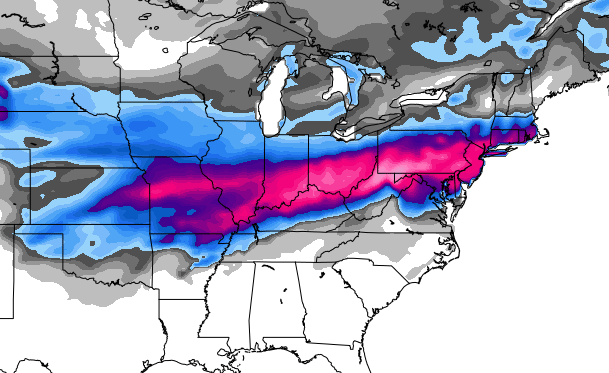
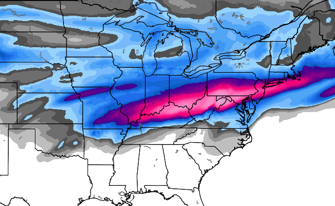
There’s nothing more I can add to the setup… you have my thoughts on it from earlier. The models are slowly coming into agreement on where the axis of wintry weather sets up. Take a look…
GFS
European…
European Ensembles…
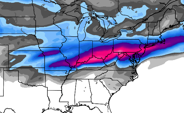
Freezing rain, sleet snow and rain are all possible across the state with the highest chance of wintry weather in the areas I highlighted earlier today.
Just because the models agree today doesn’t mean they will do the same tomorrow. Anyone else on the #teamrain train with me? 🙂
Take care.

Thanks for the update.
Yes might as well get on board because we probably won’t see anything else but rain rest of winter.
Nice agreement between the operational and Ensembles…Look’s like this is gonna happen..Now just 100 more miles south..Hey what’s 100 mile’s between friend’s..
Dodger says same folks – not KY – will get the white from another southern storm. Same old, same old. Dodger ready for spring!
Dodger!
chris, just because you are tired of the snow and winter weather doesn’t mean every one else is……go #team snow……good luck, my friend.
The same works in reverse…..
Go team snow.
Let is snow!
Thanks Chris. Here’s hoping that we either all get snow or none of us do. As I said before, ah well there’s always next winter. ;). Have a great evening all and GO CATS!!!
I think you meant Go Cards!
I’m all in with you Chris! #teamrain all the way. Anything but ice!!!!!
Does the pink mean ice or just heaviest precip?
You’d better be pulling for cold air instead or we’ll be looking at a major ice storm.
Louisville will be a mixed mess. Cincinnati will get hammered.
Team rain was here long before now that has been SE KY motto for a long time.
I’be had more than enough 34 degree cold rainstorms here in Huntington WV. Looks like I will have deal more again. As I said before Chris if you want rain come to WV.
Just wonder how much the above map’s are sleet/freezing rain/snow..Got a feeling this is gonna be a bad one for people in louisville/northern ky..These over running event’s can be a disaster sometimes..
sad that in 2014 on a thurs night no one can forecast what the weather will be 3 nights from now because the models can’t make up their minds.
Yup…I said earlier…whatever happened to when several yrs. ago, you could get a forecast at LEAST around 2-3 days out, and it would be pretty much 95% correct? NOW, you basically have to just get your butt outta bed, open the door for the dogs or look out a window and say, “Hmm…little cloudy….did I just see a snowflake, or was that a raindrop? Mighta been bird-doody…ah, well, I’ll check again in 20 minutes!”…That seems to be what most Met’s are doing any more?! 🙁
Would someone post what the colors mean on this map?
I trust the trends more than any model.
I definitely DON’T want ice!!!
Cold rain is miserable…
But I do so miss the deep snows of the 70’s…
It’s no big issue when there’s just a little ice. Usually no power issues. This can sometimes be a thing of beauty, especially if the sun is shining on the trees. Even better when the road remain just wet. So not all ice storms are horrific.
But still hard to understand how one can want an ice storm.
Even many winter lovers would much rather have snow or sleet than ice. An inch of ice is much more dangerous and destructive than a foot + of snow.
Weather Prediction Center now showing the worst of the ice storm just north of the Ohio River, especially in Cincinnati.
Of course, things can and often do change this far out in time.
I will certainly get on the rain train. No more snow, thank you. And please, no ice either.
#Teamsnow
#TeamSNOW!
The Hogs are 100% with free throws and the Kitty Cats barely 50%… at HOME. They are as bad at free throws as the models are outlooking snow around here.
They are GOOD kids, but not a very good basketball team.
Spot on! And the fibe of Bobby Knight in Rupp doing the game for ESPN meant we were doomed!
Young and Dumb team, sweet 16 might be a stretch with this bunch???
Like our winter weather in central KY, I treat this team as the Unforecastables. They match up poorly with teams that challenge them and have better guard play.
Ouch! Loosing to the hogs twice in one year hurts, but it is what it is, Cal might need to rethink this send my best players to the NBA crap, UK fans could care less about the millionaires club!
Not to many will go this year, but two that might stay are the ones we probably would want to go.
I think this team should get the Shaqille O’Neal free-throw trophy. they will go as far this year as they make free throws.
too
Hoping for rain
Snow it is
I think CB is in model overdrive mode to forget about tonight. Meow.
You are correct, sir!
Outside of a drought situation, it’s truly a sad day when people are asking for rain, yet I am as well! lol
I’ve had my fill of ice. We just had an ice event not 4 weeks ago and now we have another, even bigger storm threatening. This is nuts.
How many times in the last decade has a storm system left someone in this region with 0.5″… 0.75″… 1″… of freezing rain? 8? 10? 15? I wonder how it compares to other regions?
Mostly rsin for lexington southward. Northern ky will see winter weather, as usual. To be such a cold winter, we’ve had our fair share of rain outta systems, not as much snow, in southern/ eastern ky . Too late for a good snow this season, maybe next year.
I’m with coffeelady, we want snow down here! No ice!
Coffeady, is her actual name?
C.B. said on WKYT earlier that some of the models are showing less rain so that means he may adjust his first call map tomorrow and push everything further south, I’d like the snow but I would definitely choose rain over ice any day!!
This looking better and better (frozen over liquid) IMBY by the hour! Me likey!
I really wish the models would stop trending more towards snow. Why? Because I want snow and favorable models 3 days out are a bad sign as they always waffle and flip as the storm moves closer. Not a meteorological observation, just personal experience.
When the models are this far out, they literally play out both extremes of the equation before they settle in and fine tune their own forecasts. That’s why one day you see warm solution, then a cold one. It’s usually some blend of that by the time everything is sampled. That’s why they waffle so much.
Louisville wins,UK loses. It was a good day.