Good Friday afternoon. Your friendly weatherdude has a day off from TV duties as what was supposed to be the start of a 4 day weekend. That’s not going to happen thanks to our developing winter storm that sweeps in for Sunday and Monday.
The models continue to trend colder and farther south with the track of our storm system. That places most of the state in line for a major winter storm. Significant amounts of Sleet, Freezing Rain and Snow are showing up on the NAM and GFS models. Check it out:
NAM
GFS

If either of those two models verify… that would be a major winter storm for most of the bluegrass state. The ice potential with this is ugly. Let’s hope the sleet signal wins out over freezing rain. Sleet doesn’t do a lot of harm… it just bounces around.
While we look at these two models… it is worth noting the Canadian Model looks very disjointed with this storm. It’s latest run doesn’t bring much in the way of significant winter weather anywhere across the state or region. As of now… it’s a lone wolf and I don’t like models that can’t make friends. 🙂
I will have updates later today. Take care.

Snow train all the way.
thanks for the update Chris, looks like Alot of possibilities on the table, lets hope spring shows up soon after this next storm!
Go Canadian!!! lol
Eh?
I will take my rain event much like the past storms we have had this winter
Oh come on Andy old man winter wants to leave you a nice icey parting gift.
i could care less what it does now whether it be rain,ice or snow doesn’t matter
🙂
I just washed my carpets too, because they dry super fast when it’s cold and dry out and the heat is on inside……..Now watch it snow ……..
Thanks for the update. Last significant Ice Storm in March for KY was in 1994. We had had many major snow storms in early March–2008, 1993, and others come to mind.
Surely no one is wanting an ice strom. Hoping for just rain. So done with winter. Hate snow.
I hope these models keep trending farther south with the snow. I am so tired of 34 degree rainstorms in the Huntington WV area. We have a Winter Storm Watch right now. But I have a feeling it will change to a Flood Watch by the time the precip starts given the trend this Winter. I would love one decent snow (not an ankle biter) before Spring starts. All aboard the snow train.
Wait for the north trend. It usually starts trending back further north 2 days before the event. Models usually go through a crisis 3 to 4 days out and start shifting south. That has been the pattern this winter. I hope I am wrong and Huntington can get mostly all sleet/snow. It is a long shot but hey, weather be crazy man. Need a big event otherwise this will be a close to normal winter with a few days here and there being extremely cold.
Good news….it is 2 days out now 🙂
Alright! Hope this holds, would be great to get a real snow here for once, like 6-8 inches!!!!! BOTS!!!
Thanks, Chris. I am hoping for the models to keep trending southward, and give everyone a good snow. this looks like the best chance southern KY will have to get one…if not, I will deal with colkd rain. Do not wish an ice storm on anyone. So for me, I am on the let it snow train, but if it looks like ice, I will punch my ticket for the rain train.. (you know on a trip you sometimes have to change trains, or planes.) 😉 Will be interesting to see your thoughts later today and tomorrow, Chris. Thanks for all you do. Everyone have a great Friday afternoon! I am going to enjoy the sunshine and slightly warmer temps while I can!
Thank you Coffeelady for the snow wishes.
What happened to coffeady, you fixed coffeelady now?
Great info! Thanks for the update!
If storm system is stronger then expected will more cold air get pulled into it? Is that the trend we are seeing. I know sometimes when storm strengthens it moves northwest. Will that happen?
Yes!!
The storm will not be doing a NW shift this time around with the H pressure system keeping the phasing Low to the south and east of us.
Just accept the fact you will be making the big bucks Sunday night/ Monday Bjenks.
Also, I would be more interested in the models underplaying the cold air aloft, more than the WAA this time, also.
This has the potential to be a record books March storm.
It’s interesting that the Canadian model is poo-pooing the storm system while the other models have it turning into a significant event.
Our winter storms are like a box of chocolates, you never know what your gonna get 😉
http://mag.ncep.noaa.gov/NCOMAGWEB/appcontroller/data/gfs/12/gfs_namer_072_10m_wnd_precip.gif
http://mag.ncep.noaa.gov/NCOMAGWEB/appcontroller/data/nam/12/nam_namer_072_10m_wnd_precip.gif
It could be same bad stuff for some
I wish the maps/models came with a time frame of when it might start. Hard to decide whether or not to cancel plans without a time frame.
And here come the WSW…
Wsw for seky seems a bit drastic, must be low on their milk and bread sales
far… way back in the depths of the wonder bread bakery, sits a red phone.
WOW, the NWS goes from conservative this morning to full blown watches statewide, hopefully frankfort gets more snow than Ice now since southern KY is in the watch also??
Good sign for me, although I don’t want a big snow storm it’s obviously better than a whole bunch of ice.
I just hope the QPF numbers bust. #teamdryslot
One more biggie and I’m in full blown spring mode, but the long range 8-14 day maps say cold weather is here for a while!
When is this thing supposed to arrive? It makes a big difference to me if it arrives during the day or late evening on Sunday. Got to make a trip from Columbus, OH back home to Lexington on Sunday and need to know if I’ll beat the wintry weather or not.
You’re in trouble!
You should definitely look into changing your plans, or at least having an alternate plan ready if the forecast remains the same through Saturday. While it may not turn to wintry precip in Lexington until Sunday afternoon, further north will begin as snow/ice. I’d imagine Southern Ohio would be fairly treacherous by late Sunday morning.
May have another system to track next weekend..Looking kind of interesting..First thing’s first though..
When was the last time the entire state of KY was under a winter storm watch at he same time??
Looks ominous on that NOAA map!
Big update from the NWS Louisville on the storm, out with their first call of snow/ice accumulations and timing. http://www.crh.noaa.gov/images/lmk/pdf/briefing/Winter28Feb14-FriPMbrief.pdf
Honestly, that is still quite conservative when matching their forecast with the other models.
Maybe, the NWS will be correct. There is just so much qpf to work with, the numbers they are spitting out are quite low. We shall see if tomorrow afternoon the NWS ups their totals.
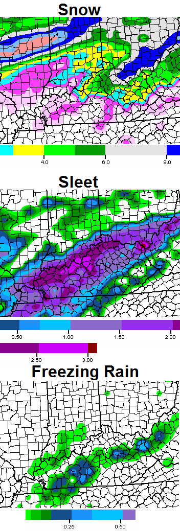
They didn’t even address the possible significant sleet accumulations. Just snow and ice. But, 4-6″ of snow is what they are going with for the biggest amounts across south central/southern Indiana? And 1-3″ of light snow for south of the river with .25″ of ice?
To me that is conservative.
Sleet doesn’t accumulate very well. I remember 2009 I think? The last ice storm. It poured sleet for HOURS, and it hardly accumulated before it finally changed to frzR. I hope it’s either snow or sleet and not frzR
We had 5″ of sleet in Louisville during that Christmas 2004 storm. It was crazy!
Did you see the qpf for sleet posted, though? Some areas as high as 3″, including Louisville. The potential is signifigant enough to mention accumulation possibilities.
I’m standing firm on it being a primarly rain event in seky, past trends and warmer then forecasted temps all week is the only models I need