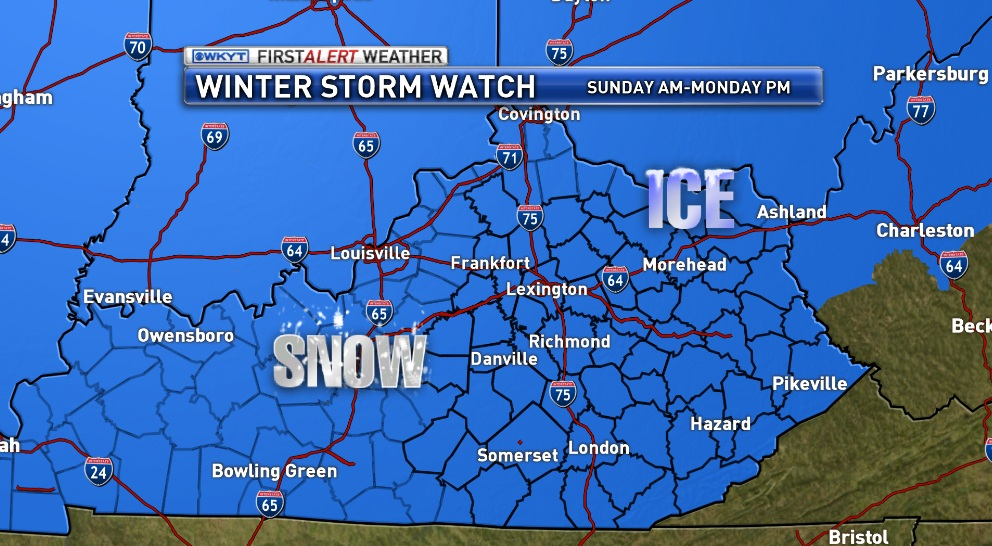
Good afternoon… again. A WINTER STORM WATCH has now been issued for the entire state for Sunday and Monday. Significant accumulations of freezing rain, sleet and snow will be likely during this time. Here’s a look at the watch…
In addition to the potential for ice and snow… gusty winds of 30mph and arctic temps will make things even worse. This has the potential to get quite nasty into Sunday night and Monday.
I want to continue to review the latest data before putting out a first call map. That should come later this evening as I continue to enjoy a nice, relaxing day off from work. Did your sarcasm detector pick up on anything just then? If not… it needs some work. 😉
Take care.

Thanks for all you do Chris!
Thanks Chris for all your hard work. All of us teachers are tired of the snow too. At this rate we wil be in school forever. Thanks again.
Thank You, Chris, for all the updates and keeping us informed.
Low 40s turned into to high 40s and 50 in seky Several days in a row the models have busted on temps. 7-8 degrees can mean a lot in a setup like this
Don’t panic……….
If it isn’t meant to be, it won’t happen…….but it will in Lexington, because I washed my carpets…….Just like it rains after you wash your car, so I’m pretty frea king confident that it will be a mess here.
looking forward to Chris first call maps, NWS seems to be underplaying totals on their update, models are showing much more juice than their forecasting at this time!
Agreed…their totals don’t match qpf output.
ROLOTOLD u in last post thT IT WOULD TREND sSE!!
So will this be an OLDSKOOL storm for ky? 😉
every storm is an old school if you ask rolo
Lol, I know right
Im on #teamrain with you Chris. This winter has outlasted its welcome and I yearn for warm convertible driving weather.
Thanks, Chris, for keeping us updated! Save those days off for Keeneland in April!!
Krogers will be rocking the next couple days, who is hungry for milk and bread??
I told Bailey when he was TEamrain karma Would get him because he a WINTER WEATHER lover deep down. kisten we had a MANY MARCH with bad winter weather.. 1987 it came a MONSTER end march first april..
I have NO idea what you are trying to say and one of the jobs in my career has been language translation and interpretation.
well you must not be too good at your job..lol
Well…I did run across a dialect or two that I had no clue about. LOL
Remember that one well…Believe Hazard may still hold the Record for most snowfall..I remember measuring 22 inches if i’m not mistaken..Power was off about a week..Ah,the good ole days..
We measured 36 inches of snow from that April storm, temperature stayed around 35 degrees and it snowed pancake size flakes.
In early April of that year we had over 30 inches of snow here in the Hazard area. I rember seeing those yellow forsythia bushes blooming and totally weighted to the ground with snow. I found several dead bluebirds around my house which had already arrived to nest and had apparently starved to death during that snowstorm. Had it been a bit colder, the snow depth would have been even greater. It snowed for two or three days before it even began to lay on because the ground was so warm.
Already seeing Kentucky Power checking lines here in Johnson County.
Weather Prediction Center at this time has the worst part of the ice storm from roughly Memphis to about Franklin KY/Gallatin TN to about Berea KY. Too close to me here in Nashville for comfort.
Almost said that ice is for the birds, but actually not even the birds deserve it 😉 .
I’m in Berea. Thanks TennMark! 🙂
This storm has a whole lot of disrespect written all over it. Looks to be a very disrespectful storm.
If the significant icing comes to fruition, power will go out for several days, especially here in E. KY! I pray more snow than ice will fall. Thanks Chris for being right on top of things as usual!!
fact is OLD SCHOOL coming!!! this will be the BIG ONE!!!
Chris,
You are NEVER off work. You are always keeping track of what is going on and what lays ahead.
That is why you are the “MAN”, my man….
Thanks for all you do. It is always above and beyond!!
Charlie
The Nam is on Steroid’s today..Look out power lines sunday night..
Bubba is silent today, he must be building his Ice shelter?
You are awesome to us, Chris Bailey!
I still believe the trend of this Winter will show itself again. Snow will fall just north of the Ohio River. Cincinnati and Columbus big snow winners again. Huntington WV another 34 degree rainstorm. Then the dreaded wraparound dusting. Been that way with every big storm this year. I just hope for once this year, we break that pattern and move the snow south.
Thanks Chris! Your the best! go team snow train!
I hope you are right Rolo; and by the way I understood every word you said.
For some odd reason, I do not feel good about this storm…. Go #teamrain!
Everything just keeps on creeping to the Southeast…It’s like that movie “The Fog”…Hopefully tomorrow Mets will have a better grip on things..Would like to beat the crowd at piggly wiggly if ice is still a player..
Why no mention of rain?
Chris You cannot complainEd about the traffic your blog is receiving this year.
This is your Super Bowl year You cannot leave the field.
There will be plenty of time For R&R Later this year.
thanks for your time and dedication.
the best weather blog in the state of Kentucky.
Just hope you do not Age Like calapari or Obama.
TWC mets are saying areas of Missouri will have thunderstorms with freezing rain, wonder if that’s possible in KY?