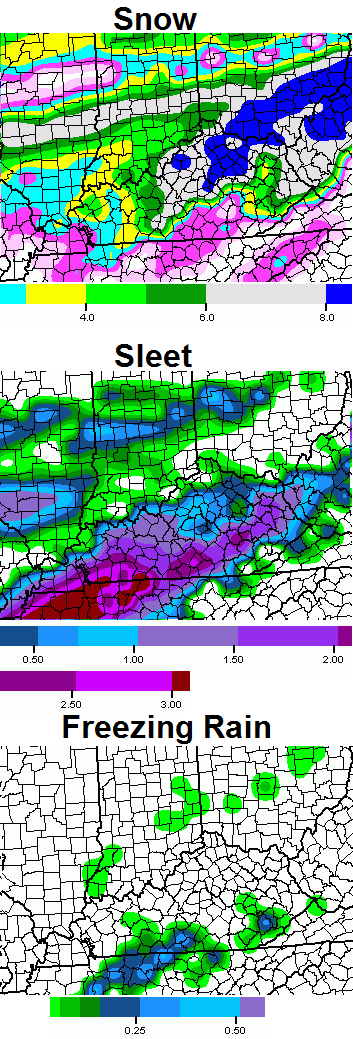
Good Friday evening. The latest run of the NAM shows a lot more snow and sleet than freezing rain. Here’s a look…
That would be a best case scenario, because freezing rain is the last thing anyone wants. I will try to get your first call out later this evening. I need to squeeze in some me time at some point. 🙂
On a side note… thanks for all you guys do. Our weather community continues to grow and February was the busiest month in this site’s history. Well over 2 million hits for the month and our server is still holding together. Try not to break it this weekend. 🙂
Take care.

Dang Chris, You jump on the rain train and we might get a Blizzard! I like the reverse jinx. LOL!!!
Kentucky hasn’t had a significant ice storm in March since 1994. We’ve had significant snow storms in March in 1996, 2008, and 2012. Hopefully we continue the 20-year streak of no significant ice storms in March.
2004 Ice storm was awful here in Lex
Might have been 2003
That was awful–February 16-17 of 2003. I was thinking about March ice storms in particular–
It was February 1994. And at least here in Southern Ky it was the worst Ice Storm we ever had, about 3 inches of ice.
– Kentucky: The south-central and
southeast sections of the state were
hardest hit. Ice accumulated to over
7 cm in some locations. Over 190,000
customers were without electricity at
some point, with power not restored
for over a week in some locations.
Kentucky also reported 150 injuries
for the event–the only state to
officially report a significant number
of injuries. Damage estimates were
placed at over $50 million for the
state.
courtesy of National Climatic Data Center
I remember it well. I was in my second year of college and I lived close enough to walk. The snow was up to my knees almost and it finally got so bad the college closed down for at least a week.
Make no promise…lol
This looks to be the biggest snow of the year.
For some areas, that is not hard to do 😉
Thanks for all you do CB! Appreciate all of the updates and accurate information. I am a teacher/wife/mom, so I know about the need for ‘me’ time. Enjoy! :o) Hoping for a couple more days here of snowball fights, snowman building, and sledding !
Henry from accuweather has Kentucky only in 1-3 inches lol
I would rather have 10+ inches of snow than .25 inches of ice/freezing rain!!
I need to wait 18 more hours before the NAM is going to make any sense of this, which may not happen at all. Models short circuit when dealing with Kentucky.
Well, good thing I didn’t have anything planned for Fayette County’s Spring Break. 50 bucks on it getting cancelled after this event.
No, thank you for all you do. Without you, I would not be able to predict snow days for the school I attend. 🙂
Let’s hope this things continues to trend south! I’m really hoping the ‘donut hole’ regions (south central KY, middle TN) can have a decent storm. Shut out so many times this winter.
Why is rain no longer being mentioned?
Rain isn’t news worthy. …
depends on where you live
and how much
Very true!
Or the trend is telling them mainly frozen stuff for the event and the main rain is the kind that freezes on contact. That, or they simply forgot to mention rain 😉
NWS has Frankfort getting 2″ of snow.
Anyone wanna guess on amounts for Berea?
If you keep track of forecasts vs. actual, and not just random perceptions, you know that Berea bets on the min or below for every forecast and we win that bet.
So it was written, so it has been, and so it shall ever be.
Just took a glance at the GFS..Could be wrong but looks like it Shifted more south..Keeps this up we will have sunny skies for sunday-monday..lol
i heard 1 met say that it shows 1 inch of freezing rain from the forgotten land of Laurel County south to TN border
If this were a three section totem poll of priority for our area and mainly frozen stuff, our luck would be:
Ice
Sleet
Snow
That is one Ugly totem pole.
Probably a Tn met cause nobody else will discuss our area.
nope it was a KY met
SE KY is the redheaded step children of KY
I can see sleet really cut into any totals for a lot folks like one of the previous events that was supposed to be the biggest since 98 (for a lot of areas). Remember from last month? It turned out to be mainly sleet for most of us. That is FINE rather than ice, so not complaining.
Ice I will complain about.
Agree, sleet may kill totals like it did in the promising snow storm, Bubba buster, Andy satisfier, Dome buster, OLDSKOOL, etc, etc, etc last month.
Really? The last “event” we were in the 4″to8″ range and received a dusting of sleet (that’s being generous), no freezing rain (thankfully), and a lot of rain. How exactly did sleet lower our snow totals when we received so very little of it?
To each his own, that storm put down an inch of sleet and 4 inches of snow in lex. It was on the ground for 14 days.
Thanks for your dedication to the cause. I enjoy your blog
I’m glad people are realizing this is the best source for Kentucky weather info, but I would love a March where all we get is sunshine and sprinkles and I didn’t feel the need to check this site as soon as an update is posted. No offense Weather Dude.
I agree. CB updates this site more than any met in the state. Some local sites don’t update for 12-24 hours. I check this site many times a day throughout the year. CB tells it like it is and it’s fun to armchair forecast.
The low is still off the coast of Cali. Wake me up when it comes ashore.
Really, This.
KARMA Itold Bailey, in a bad winter it will be rough thru MARCH.. and if ur a winter luver u cant jump ship, no matter what time of year of year it is..
I told the blog that OLD SCHOOL CIRCA 1987 was very possible in MARCH.
I see 12 incheds plus from RICHMOND north right now. 6-10 for rest. that right now as well as sleet in the S/SE. if it keeps trending south lookout.
I see mainly sleet for a lot of us and you see snow. As long as nobody mainly sees ice, we are good- whatever it is 🙂
Warm air always tends to bust things up around Kentucky, so I stick with the trend for now. Ice is the concern for now. WAA is a bad acronym.
I dont see “old school” here in Bell, Whitley, Knox, McCreary, Harlan, and the southern half of Laurel and Pulaski counties. Mostly rain, possibly some freezing rain mixed with sleet. Topped off by some back end snow showers…little to no accumulation. Looks like northern half of Laurel, Pulaski and north have a decent shot of accumulating frozen precip. Of course this could change but I doubt it will move farther south.
I see nothing for now that makes this any different from our other events that make Kentucky the fence. Cold air and warm air battle until the moisture is mainly gone. North of 64 has a shot, but sleet/ice/rain the further south of that.
That is unless it moves more south, but we had a similar event go mainly sleet, thanks to warm air. The more the moisture draws up, the more it would appear warm air defines the fence and gives a good snow to the north. So far, it has done this every time. Why stop now?
Will be interesting to see CBs take.
As I have said since early in the week. The trend will win. Ohio River North is sweet for snow/sleet…Ky 90% Rain…. Freezing rain is real possible Ohio River to the Parkways.
keep toking rolo
I’m standing firm on mostly rain in seky
Have been in DC all week and now in Nashville. Suppose to head back Sunday mid morning. What is the timing of all this? WW
The NAM if verifies would give Frankfort a 6-10 inch snow, that would be a good way to finish out winter!
The NAM says Bam?
looks like nam has much warmer temps. looks like all rain below ohio river temps near 50 on sat
huh?
Yes Tim thank you for that its suppose to be near 50 on Saturday. The winter storm is not till late Sunday evening through Monday morning.
Through Monday evening I believe
The cold air won’t get in here until after the LP has moved off to the east and north a bit. You’re right about the temps on saturday but if we get any frozen precip it’ll be sunday/monday
Seems reasonable right now, since you are accounting for the mix 🙂 As long as not mainly ice 🙁
Mainly sleet will be a win! Folks here should have stopped doubting warm air impact over KY a long time ago.
it was bar talk i heard sorry
no sorry they are calling for 4+of snow and 1/4+ of ice here .no good
I’ve got a first call for snowfall and a precip type animation from the NAM on my blog if anyone wants to check that out click my name (CKY/EKY).
Looks to me like sleet will steal the show here in SEKY. I don’t think we will have much of a problem with freezing rain but time will tell…
Yet again, the sleet/frzg rain stuff is sensitive! Will change every run til the storm is here
Nice Blog.
I posted in your post above about your map. In summary: Warm air will probably not be denied for most of us. It will take a purtee’ good rationale by CB to convince me otherwise. That said, CB has not had much luck with bigger systems in regards to central/south central KY. The models betray him more than not.
For now, seems a big snow for most of us is as likely as the Kitty Cats improving their free throw percentage 😉 ….. 🙁
Agree 100%. The majority of our *snow* totals here in SEKY will be dependent on any back end moisture that sticks around after the front moves through.
You GoTchu a nice lil blog dare bud. Lookin good brudda…
its will be a wilder ride
I have a question if we get to 55-60 Sunday here in SeKy,how would it be possible to have a winter Storm with Snow/Ice/Sleet that night or next morning?
A very strong Artic Front is moving in
After the most of the moisture is gone 😉
why not it happen throughout the winter in Denver.
I hope the southward trend continues but I am still skeptical that rain will not win out in the Huntington Area. Once it warms up here it is really hard to root the warm air out. Seems we get down to 34 and stop dropping.
WOW! You think it’s hard to forecast here in this winter storm for our area?!?!? This I probably a piece of cake than trying to forecast in Kansas City at the moment. Their discussion is INSANE! I really recommend you guys read this, I have never read a discussion of a winter storm this complex! I would say more, but you guys do the reading and see for yourself. (Caution: High usage of weather geek language, you may or may not understand.)
http://forecast.weather.gov/product.php?site=NWS&issuedby=EAX&product=AFD&format=CI&version=1&glossary=1
not sure what all of that meant, but frontogenesis is my new favorite word.
Yep, Phil Collins sung for them too.
http://www.youtube.com/watch?v=YkADj0TPrJA
OMG. that’s hilarious.
“Most known chemical treatments will simply be ineffective” preceded by detailing the items to have in your car when you are stuck on the road and the breakdown of what all the possibilities are. Great read. I like reading the similar ones from nws lmk but this one had some great wording!
so just out of curiosity what does the coolest weather dude do during his “me time”?
Dreams about you.
It is Like a cold front That meet a warm front.
Knowing Chris I would say look at computer models 😉
LOL!! I was thinking the same thing. you think he has an alarm set for when the new models run?
Probably!
The NAM in its longer range sucks. It’s all over the place
What do you mean?
Looks like the second wave is stronger…3rd wave is our baby..Got a feeling it’s gonna be a jaw dropper..
New NAM is slightly colder and juicier so far
Good, now if tomorrow’s runs can shift the heavy snow to south KY, then wait for the last minute northwest jog and BAM, CKY gets hammered.
NAM 0z is pretty much consistent with 18z. The LP is shifted southward ever so slightly and the precip shield is about the same..
Does that mean for snow for west liberty or less?
That run was a head scratcher to me..Looked like the low tracked through Eastern Ky on the 500 maps..Still amped up but not as strong imo..
Man i would hate to be a met right now..lol
Currently rethinking my career choice. LOL
If the model’s has a hard time trying to figure out what’s in store imagine being a Met and trying to figure out the Model’s..Believe you’re right though in the tick south..
OK guys, give me your best guesses here.. What’s it looking like for NE KY, from Morehead- Ashland? If you say ice I’ll have to hunt you down 😉
Would not want to even guess..In other words i have no clue..Guess this is why Bailey makes the big bucks..Will say i did not like the Nam run..GFS and Euro should be interesting..
What was wrong with nam run
Dodger having fun watching the board go nuts while Mr Bailey needs a break. It’s been a long winter! Dodger!
Nothing like having a night off and getting sick. That’s the luck I have this winter. Am trying to look over the latest data to get you guys another update in a bit. It might be short and to the point until I can actually stand to get around food again.
hope you feel better soon
OH NO!! rest. this one will knock you out. took my whole family down in one week.
Go to bed and relax…Weather can wait…
You need some rest Mr. Bailey, you have big updates to do before the storm hits. Hope you get better, no need for a big ol’ update tonight.
Dude, don’t worry about updates tonight. They can wait. Go get some rest. You’re going to be a busy Met the next few days…
So sorry you are sick. Hoping for a speedy recovery. I have seen a lot of that in the clinic the last ten days.
Chris I hate that you re sick you just wear yourself out for your bloggers get some rest that’s the one thing we can’t have is you being sick…
wow! ton of comments…this coming storm sounds serious.
get better soon Chris and enjoy your time off.
The GFS should be running right now. has any of our experts seen anything note worthy.
Well, this whole storm system has a little of everything in store for Ky. Glad I am not a professional trying to figure this one out.
Feel better, Chris! The weather will still be here tomorrow! You need to rest!
The main part of this winter storm is still off the coast of California, tommorrow will tell much more about the track of this thing, could still flop either way I think, south east or north west shift could happen????
futher south it is..
That’s what I heard
You know how much farther south?