Good afternoon, gang. We continue to deal with a fantastic period of March weather here in the bluegrass state. This will really get a serious case of spring fever going over the next few days. We may hit 70 by Tuesday with mostly sunny skies. Then… reality smacks us in the face! Winter comes back in a big way.
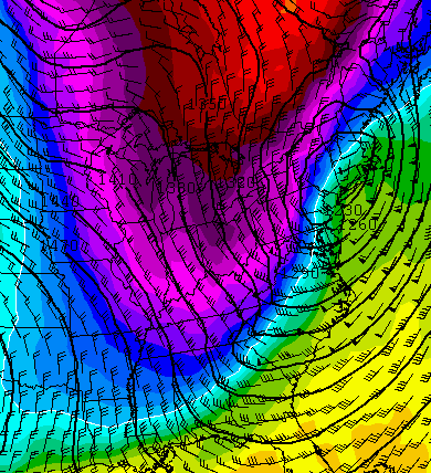
A storm crosses the region on Wednesday with a 30-40 degree temperature drop with 30mph wind gusts. Rain will change to snow from west to east and some light accumulations look possible. Check out the shot of cold coming in behind this storm…
 Wednesday night thermometer readings will drop into the teens for most of the region…
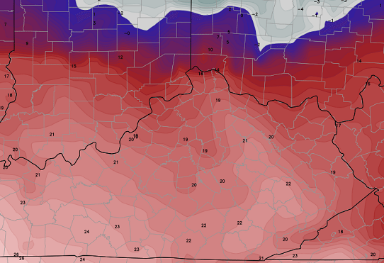
Throw in gusty winds and wind chill readings in the single digits will be likely into Thursday morning. That will be followed up by sunny skies on Thursday with highs in the 30s.
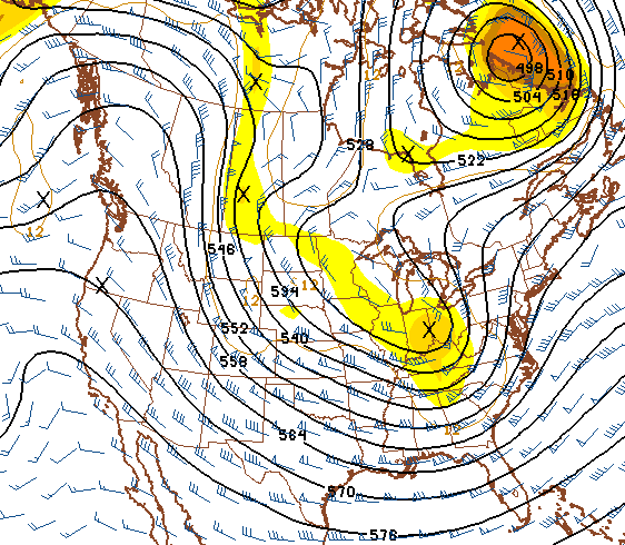
Friday will see a nice warm up with highs back in the 50s. We could push 60 into early Saturday ahead of the nest storm that threatens the area. That one looks interesting for next Sunday into Saint Patrick’s Day.
The pattern that follows that up is also interesting…
I wish I could say we’ve seen the last of snow on the ground… But, I can’t. At this rate… flakes in early April wouldn’t surprise me.
After all that… enjoy the rest of the day and take care.

All I can say is spring cannot come soon enough tied of all the cold weather.
Tired not tied.
LD this was a reply to you, but new post came up now.
Like a lot of others have, just imagine the big bucks they could have by releasing the data out to the public with advertisements. I’d rather access models for free and be annoyed with ads than to pay like most other people.
The US should really step up its game in forecasting. That contract with IBM is killing us, it was not a good idea. I just really hope they get out of the contract, I do not want to wait 4 years until a upgrade.
To anyone who would like to know what I’m talking about http://tinyurl.com/k5dz3c5
So, it may not only be the computers that are relatively antiquated. The models themselves may also be an issue. For example, it’s said the GFS is somewhat outdated compared to the Euro (even if GFS and Euro have somewhat different “sweetspots” in forecasting into the future).
The FIM model (click here) is currently under development as a possible successor to the GFS.
Looking forward to spring and severe weather season? Me too. Check out the birthday cake that was made for me: http://ekywx.files.wordpress.com/2014/03/1622184_1429797737266640_918667316_n.jpg
LOL
Cool cake!!! Although hopefully that was more of a generic copy of a miscellaneous hook echo and not from, say, the West Liberty tornado or any other infamous twister. Nevertheless, hope you have many more happy birthdays!
I believe it’s a signature they found on google from a storm in Oklahoma a few years ago. I thought it was cool too!
While we’re on this note, NWS Jackson KY is conducting more SkyWarn courses in east KY.
http://www.crh.noaa.gov/jkl/?n=spotter
NWS offices at Louisville, Nashville, Paducah, Morristown TN, Wilmington Ohio (their jurisdiction covers parts of northern KY) are also offering SkyWarn courses in their coverage areas. At least at this time NWS Charleston WV (which covers parts of east KY) has no SkyWarn courses scheduled at this time, but IIRC you can go to a course handled by another NWS office and still get credit.
Thanks Chris. Hope these next two systems come and go and let a more spring like pattern settle in. It is getting toward mid March now and time to start the early outdoor gardening. Not fun trying to do that at 30 degrees. Did notice earlier today that the trees are starting to get some buds on them. Hope they don’t get killed out by the cold. Have a great Sunday evening all.
Wow. Snow chances in April? I must be living right. I love the give and take of spring. Sunny, clear days give way straight into rain and snow and then flip back again. It’s wonderful.