Good Monday, everyone. Spring is doing its thing out there today and will kick into high gear by Tuesday. While we are all in full blown spring fever mode, it’s Old Man Winter who is looking to crash back into town. We have a long way to go before we can full break out of the nasty winter pattern.
Temps today will warm into the low and middle 60s for most of the state under mostly sunny skies. 70 is a good bet for many on Tuesday as clouds stream in during the afternoon. Those clouds are ahead of a strong storm system that rolls across the state on Wednesday.
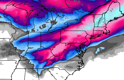
This will cause our temps to CRASH. A 30-40 degree temperature drop will be likely as winds gust to 30mph. Heavy rain will change to snow quickly from northwest to southeast…
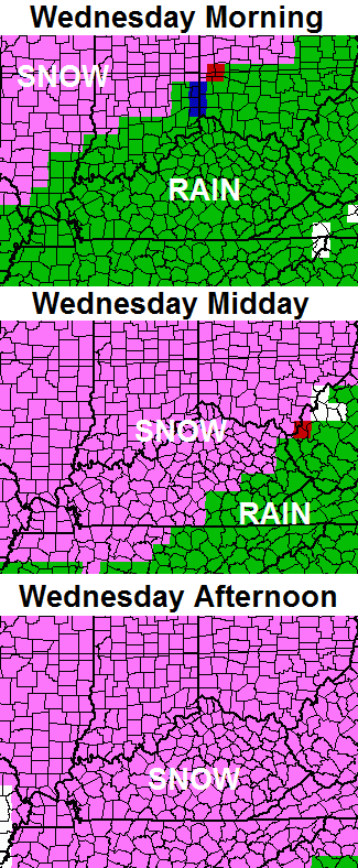
Light accumulations will be possible into Wednesday night as flurries continue. Lows by Thursday morning reach the teens in many cases. Gusty winds will make it feel even colder than that.
Thursday will see a cold sun returning with highs in the 30s.
After a nice mild up for Friday and Saturday… another storm system tries to bring a blast of winter our way…
There could be another wintry weather maker coming in behind that later next week. FOR FUN… the European Model has a lot of winter precipitation for a lot of people over the next week…
Yep… it’s the winter that will NOT end!!
Take care.

When do you see us breaking out of this pattern Chris?
Chris hasn’t said anything, not even a hint as to when we’ll break out of this pattern. He did say flakes may still be flying in April though. (Eeek!)
That doesn’t sound good Israel. I don’t want to go straight into summer. Ugghh
he’s not said anything because he don’t know — nobody knows – weather forecast are good only about 4-5 days out and that’s pushing it. Back in Feb he thought all of March would be wintry – I live in London and we are 10 days into March and we’ve had 7 days above the normal temp of 54, plus looking at temps in the 70s …. I think so far that is pretty much a typical spring March.
Maybe in London–Lexington is running 7 degrees below normal so far for the month.
but thats always been the case the land of the forgotten has a different climate than the rest of KY thats why it rains when the forecast is for snow and temps are 10 degrees above forecast as well
Where is blog policeman, Jeff Hamlin? I can’t believe he let you by with that comment.
From what I’ve read elsewhere, possible severe event around the equinox (still waiting for a yea-or-nay mention on here), cold air breaks down for good after and then an extended period of severe weather possibility during the first two weeks in April.
I love this pattern.
It’s totally possible to have snow flakes in April. I remember some a few years back on Easter. I have an elderly family member with a late March birthday, and she has seen snow on her birthday several times.
Good thing is that the warmer days seem to be outnumbering the cold ones. Last year, up until the end of March, pretty much every day was below average. I will take a cold day once or twice a week. That is typical March weather.
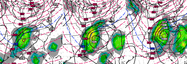
NAM hi res simulated radar shows some storms embedded with the warm side of this storm for Central and East Kentucky.
Also, it’s interesting that this system continues to slightly trend north even though there is not much reason for it to. If you look to the south of the LP, there is nothing blocking it! No high pressure to keep it from cutting south. Also, there is so much pressure to the north of this storm with the cold air in place.
I think this one may be modeled too far north. Even if it isn’t, the cold air will certainly come in faster than a lightning bolt with all that pressure.
In theory, though.
The main thing steering this thing north is the strength of the LP alone. I’ve seen stronger ones cut below cold air blocks.
But yeah, I’m not saying this one WILL cut south just because of the lack of blocking.. Just an observation.
Yea, I’m pretty sure it’ll play out like that too. But what causes the models to steer it too far north, just a model error?
This pattern is here to stay for a while. Not saying it is going to snow in June, but the shots of cold air will be prominent throughtout the spring and summer. This may be our new norm for several years to come. Weather runs in long cycles. The new cycle is somewhat of a mini ice age with cooler temps for all.
contrary reports on a “new” norm ….. el nino typically brings warmer winters
http://www.foxnews.com/us/2014/03/06/forecasters-expect-el-nino-ocean-warming-this-year-may-provide-relief-for-us/
Wouldn’t mind some shots of cooler air in the summer.
I am with you. Although I have a pool and if the water does not heat up no one swims and that can be a big waste of money. I don’t think it ever got above 80 degrees last summer. Not that 80 degrees is cold, it is just that 90 degree pool water feels much better during the evening/night time swims.
I saw where on this date in 1960 Kentucky got over 24 inches of snow which caused buildings to collapse. I guess that’s what Rolodex means when he says old school.
Meant rolo dam iphone
Rolodex is about right. that fool has multiple personalities…
Thanks Chris. Looks like we are going to get teased with spring like we did with winter for a bit. Hopefully, we will get through this and get some better weather by the first day of spring. Also, do you think we could possibly trick the dogwoods into blooming while it is cool already and get that out of the way as well? Probably not, but its a nice thought.
For you people who are believers of old sayings, it did thunder in February, so that means it will frost in May. (Happened last year.) In any event, today and tomorrow look wonderful so I am going to make the best of them. Have a great Monday, everyone! Thanks again Chris, for all you do.
I’m like Jim seems pretty normal to me
Expecially here in SE ky. Not much snow
This year a little ice storm that did nt cause
Any problems . And a few warm days here
and there And a few cold days here an there
It’s march an anything can happen. I’ve seen
It snow in April an May before good thing about
That it melts fast
This March is nothing like last March. We are having lots of nice dry days in between systems now. Last year was bone cold the whole month. Right now we’re getting a weeks worth of sunshine in between these big systems. What more can you ask for?
I see buds on a lot of trees and plants just waiting to burst when the time comes. Already flies and bugs are coming out of hibernation. Clocks already forward an hour. Warm days about outnumbering cold days by a little. Already meteorlogical spring. Astronomical spring starts next Thursday. Guys, we still have cold days left but true spring is coming soon! Hopefully we dont get 6 inches of snow in May like it did in May 20 1894.
I don’t know–even yesterday was below normal for this time of year for Bowling Green, Louisville, and Lexington. The month is running 7 degrees or more below normal. Compare this to March of 2012!
That seven degrees below normal is mostly caused by those two days in the 20s for highs in central KY. One day it only got to 21 for the high. For a comparison standpoint, March 2013 only had two days above 50 at this point, in the same time frame 2014 has produced 5 days above 50 in Central KY. I’m liking 2014 month of March a whole lot better. From my perspective anything above 50 degrees is good.
As Ryan touched on earlier, a few thunderstorms may be possible just ahead the cold front. Perhaps at most an isolated damaging wind threat.
My in-laws in Bowling Green report that the snow/sleet/ice are finally gone, save for a few sheltered piles where the sun can’t reach. Bwg had had relatively little snow until a week ago, but now Bwg is up to 10.1 inches snow since last fall. Yet go the short distance to down here in Nashville, we’re still 1.5!
Hit 68 here in Carrie of knott co today
Thanks Chris.
I could handle a mega March snow but today sure was nice.
As for late snow etc., I can recall a Derby party several years back, it spit snow and ice…