Good Tuesday everyone. Old Man Winter isn’t going to go quietly into the night. We have a wild setup on tap as we head into the middle of the week. It’s one that will bring another shot of cold and snow our way. To make matters worse… this isn’t going to be our last round from the old man.
That makes today’s weather that much better. Highs will hit the upper 60s to low 70s on a gusty southwesterly wind. Get out and enjoy!!
Things change tonight as low pressure works into the state from the west. This low will bring heavy rain and a few thunderstorms in here overnight and early Wednesday. Temps ahead of this storm will be well into the 50s. Then… the bottom falls out.
The low works to our east and temps drop through the 40s… the 30s and into the upper 20s by early evening. Rain will change to a period of snow that takes us into Wednesday evening. Some light accumulations will be possible during this time.
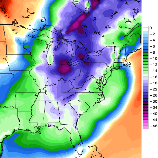
Temps will drop into the teens to start us out on Thursday. Gusty winds will make it feel 0 or below at times. Wow!! Highs later in the day will stay in the 30s with partly sunny skies. Check out how far below normal those temps will be…
Friday and Saturday will feature highs in the upper 40s to low 50s as winds continue to be gusty. Those gusty winds are ahead of another storm that looks to crank up later Sunday into Monday. The European Model has a rather threatening look…
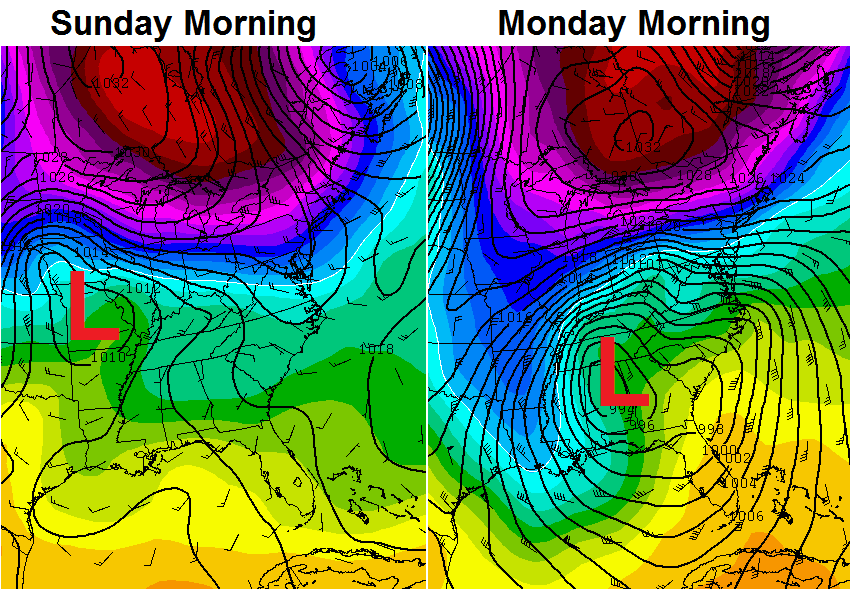 Rain? Snow? A combination of the two? We will figure all that mess out as we get closer. If we can get that storm to stay separate from the main stream, it could just hang around the deep south and not have a huge impact on our weather. I doubt that happens. Why? I’m supposed to have another 4 day weekend.
Enjoy today’s nice weather and take care.

I’m sorry your 4 day weekends keep getting messed up, Chris. Maybe there is something to it, though? As a snow lover, I suggest you try and take more 4 day or even 5 day weekends next season LOL.
If you look on my blog (click my name) I have an animation of the NAM sim radar and it shows three lines of storms popping up on the warm side of this storm. As of now, looks like NEKY has the best shot of seeing some gusty storms and maybe an isolated severe wind event.
I’m gonna enjoy this weather today, I hope you all do to – it’s gonna be fantastic out.
LOL, Chris! We’ll keep our fingers crossed that you get that 4 day weekend!!
We need a good half inch or so of rain to wash away the salt and get rid of the snow piles once and for all.
We DON’T need more snow on top of that to bring more salt and snow piles.
Interesting. You can see the trends and how warm periods are starting to become stronger and longer. These are the climate graphs for Lexington. These graphs are great for seeing trends, and cold/warm periods and precipitation.
http://ow.ly/i/4ReAE/original http://ow.ly/i/4ReB5/original
I agree, it is clearly a warming trend but all we hear about is the “winter that will not end.” The average high for the last 22 days (going back to MID-FEBRUARY) has been 50 (counting today). It is also forecast to be 50 or above 7 out of the next 9 days. I call that spring and wonderful.
It is the winter that will not end. Sorry you have a skewed view of it all.
I am really sorry that an optimistic and positive view of actual facts is considered by those in the media as “skewed.”
Thanks Chris. Next winter you need to plan those weekends when we are all wanting snow! Hopefully you will get this one and it won’t get nasty. ( and I have beachfront property in Tennessee to sell, too.) ;). Enjoy today, everyone. Make it a great day!
Man, I’m ready for spring! (And I hope you get to enjoy your 4-day weekend, too!) Thank you for your hard work! 🙂
I can handle a cold day threw in between multiple warm days, typical march weather