Good Thursday to one and all. This is a good looking, but a cold feeling day across the commonwealth of Kentucky. We do have a warm up coming our way over the next couple of days. In true Kentucky fashion… it won’t last long. We could see another round of rain and snow coming late this weekend. Yippee.
Highs today will warm into the mid and upper 30s across central and eastern Kentucky and into the 40s in the west and far south. We will see a nice rebound in temps for our Friday as readings head toward the 60 degree mark on a gusty wind blowing. Skies will be mainly sunny.
Saturday will find a cold front sagging into the area. This will fire up a shower or two as the day wears on as temps hang around in the 50s for highs.
That same front will bring colder air in here on Sunday as low pressure develops to our south and heads toward the Carolinas. The Canadian Model is similar to recent runs of the European Model and shows rain and snow for the region…
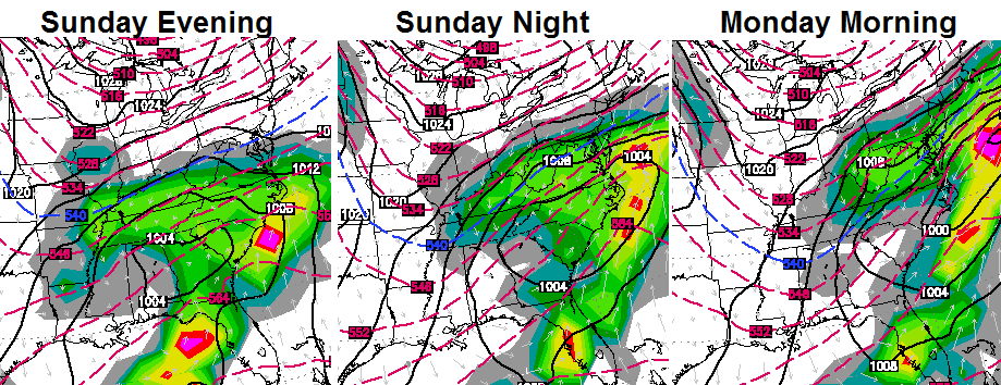
That is something we will need to keep a close eye on in the coming days.
Another system is going to try to dive into the region from the northwest by the middle of next week… 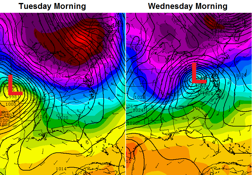 Yep… the hits just keep on coming!
Have a great day and take care.

Thanks Chris, but lets hope these next storms trend north like the one today, a couple cold shots here and their is fine but significant winter weather looks doubtful from here on out!
Typical March weather. Really cold Winter weather is pretty well over. Expect rain next week.
27 here in Carrie of knott county models once again over play cold air
only got down to 28 in London, was supposed to be in the teens …. didn’t happen, about like the snow — nothing ….. rains from here on, say goodbye to this winter, thank goodness cause I am tired of it.
ECMWF ensembles sure look pretty right now. I smell a nice warm up towards the end of this month.
19 in Lawrenceburg, KY right now. Looks like 20 in Frankfort and 21 in Lexington. Temp will probably drop another degree or two before sunrise.
22 deg this morn at my house with a good dusting of snow!
1-2 inches of snow at Dorton in Southern Pike County. Roads were slick and snow covered.
March data through yesterday March 12:
Normal average temperature: 42.6
2014 Average: 39.3
2013 Average: 38.8
2012 Average: 46.0
End of Month Data:
Normal Average Temperature: 45.5
2014 Average: ?
2013 Average: 39.5
2012 Average: 56.3
what area is that for ?? curios, cause London is way above average so far for March …. avg is 47.10, but currently our avg is 56.08 …. the avg of 39.3 seems awful cold since we haven’t had that many days
Jim Jones it looks like you’re looking at the average high temp not the average temp.
That is for Lexington and the average of highs AND lows combined, not just highs.
Like Israel said, that is factoring both high and low temps for the year. Average highs in Fayette are running about 5 degrees more than at this time last year and that is factoring in a 21 degree day high for 2014, which would skew the results quite a bit. March 2014 has already produced 7 out of 12 days with 50+ degree highs (Fayette). At the same point in 2013 only 3 days greater than 50. Pretty typical spring weather compared to last year.
To be more clear. I’m referring to the month of March and not 2014 as a whole.
What light dusting we had here was melted by 10 am sun is real powerful this time of year
I hear the winter lady singing goodby
And I smell spring in the air.
A very light and dusty snow here in Russell Ky- so light it blew away and is already gone.
If I’m gonna get snow, this type ain’t bad 🙂
Hey bring it on…..I am so tired of Summer’s hanging on or beginning soon. You know like 100+F in early September and 90s well into Sept? I am happy to see Winter finally do the same. I can live without the oven this place has become in Summer for the most part. I remember summers in the 1960’s that were pleasant with nice puffy clouds and playing baseball all day long with no problems. Our summers have become unbearable for the most part since the 1980’s. Some here and there that were nice but not many. Winter you are welcome as long as you want to stay, or at least take some of the wind out of the Spring and Summer sails.
yes. i am in agreement here. i love sommer. i just don’t love living in an oven.
We are heading into a cooler cycle for the next decade or two. Cooler summer and cooler winters will be of the norm.
It is definitely March…I just came in from outside, where it is 25 degrees at my location but it definitely did not feel that cold.
Well. I’ll resign myself to lurk status again, and enjoy the weather as it comes. These storms are welcome. Good continuous moisture and the fronts help keep the heat from getting stupid. Those 80 degree temps can hold off until June or July.
Nope I wouldn’t mind 80s in April at all.
No thanks. 65 and sunny is perfect.
If it could be 65 all day and night I might would take it. One thing I like about summer is that the wardrobe choice pretty much makes it from daylight to dark. This time of year is hard to dress for. Cool mornings, warm evenings and cool nights make it hard on the laundry.
so i’m not the only one. 🙂
That is just your opinion and not fact.
Pretty much living in the wrong state if you want cooler summers. So much water coverage in Kentucky makes it a prime spot for high humidity.
Now it’s Indiana’s turn (next week actually) to have Severe Wx Awareness Week (click here). True, the link is from NWS Wilmington OH; while Ohio has already had their Severe Wx Awareness Week, NWS Wilmington OH covers part of southern Indiana as well as northern Kentucky.
18z nam has anyone gather to look at that for Sunday/Monday!?!