Good Friday, everyone. We have a much milder day in store for the bluegrass state, but the focus of the forecast is on another winter weather maker. That system looks to arrive later this weekend with rain and snow for much of our region. This continues to be part of a pattern that still shows no signs of spring locking in.
High temps today will warm into the upper 50s to low 60s on a gusty wind from the west and southwest. Wind gusts of 40-45mph will be possible. There is a weak front dropping in later tonight into Saturday. That could spit out a shower or two, but Saturday is looking a little better. Winds will be gusty with temps in the 50s for highs.
The fun begins Sunday as cold air bleeds into the state from the north. This happens as low pressure deepens across the deep south and rolls toward the Carolinas…
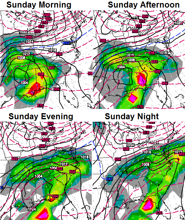 That is likely to bring rain and snow our way on Sunday into early Monday. Some accumulations will be possible… especially Sunday night. It wouldn’t take much correction on the models for this to turn into something bigger. Given I’m supposed to have another 4 day weekend… that’s probably what will happen. 😉
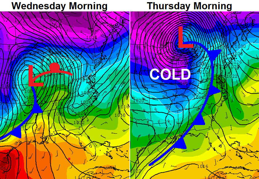
The longer range pattern continues to favor colder than normal temperatures as several systems dive in. The next one comes later Wednesday into Thursday…
 Again… I can find no signs of sustained spring weather through the rest of the month. I know… it stinks.
I will update the late weekend potential later today. Make it a great Friday and take care.

Blah!!! You do realize we’ve been cold & snowy for 6 months!!!! That’s half of a year!! We had snow on Halloween!
I know what you mean. It really bites.
Yep I had heat on a few days in October.I normally love winter time but its really wearing me down this time around.It has also cost a lot more for utility bills than average the last few months.I am looking forward to nicer days.Of course we may jump from this to 6 months of sweltering heat.I think the duration of it all is getting to most people by now.
Still running ten degrees higher for the average highs in March 2014 than last year. I will take it. Nine days 55 degrees and above for March 2014 compared to only three at this point in 2013. Weather is still not great but substantially better than March 2013.
Above numbers are for Southern KY . I think Central KY is running 5+ degrees warmer for March 2014 highs compared to last year.
No it’s not S KY anymore it’s N TN since we don’t exist in the state. I love the stmt no sustained spring for the month — it’s been spring here 11 out of 14 days and no signs of letting up. So to all you forgotten ones from the promise land S and SE KY I say happy spring ! To the rest, good with luck with the joke winter.
Meh!!
NAM has been trending this north an significantly stronger. At first, 18z runs yesterday had Lex in the bull’s eye for 5″, then rhe 0z run trended on/just north of the fence with 8″+ possible. Now today’s 6z has trended even more north bur stronger with 12″+ snow in Indianapolis. Not suprised at all, besided, we’re sick of snow now right? Not me… I’ll take spring or winter!
And the GFS has been trending south.
18z had I-64 and north with 1″. 00z with 2″. Now the new 6z with 3-6″. The 6-8″ line is right above that.
Me too. I’ll take spring or winter now. It makes March fun.
Thanks Chris
The Winter that keeps on giving
Chris,
I think there are a lot of us hoping and praying that you get that 4 day weekend. Thanks for all of your hard work!
Another rain maker for seky
I’ll take it….. I personally don’t care for the white stuff this late. Bring Spring permanently!
GFS has a bit of sleet and freezing rain training over CKY with this 06z run. NWS Jackson actually has ZR in the forecast for many areas on Monday.
What do you think about this system, just some early thoughts? Will it keep tending north like the NAM lately? Is the high pressure in the great lakes going to push this more south than expected?
12z NAM adjusted south, just like the GFS.
Anything could be in play this time of the year.
This is about the same time we got over a foot of heavy wet snow back in 2008 (Louisville).
Pretty much normal here in lily
Cold warm cold warm. That’s how march
Goes here. We have had quite a bit if cold
This winter. But not one snow over ankle
Deep.
Chris ……..
When these events happen, and you’re scheduled for a 4 day weekend, why doesn’t the person scheduled work overtime instead of you having to drop everything and go into the station? Just wondering? Perhaps it’s a contractual thing during severe weather days?
Man. There are more springtime negative Nellies than their wintertime counterparts. These cold shots turn warm quickly. The sun is high in the air and packs quite the punch already. It is spring now already, and the idea we have had six months of winter is maybe a bit on the jaded side. January and February were locked in for sure, but the rest not so much.
Thanks Chris. Looking at a wet weekend and probably a snowy one
foe some. I keep hoping that you get that four day weekend, because that means mostly a rain event, although I feel like we have had our share that to the point that the ground is still saturated in our part of the state. What we need is a few days of dry weather, but from your outlook, I don’t see many of them stringing together, either.
Oh well, it is what it is. Everyone have a great Friday! And GO CATS!
Well, this time 21 years ago, a lot of us were hunkered down (or just coming out to survey the wrath) during the infamous Blizzard of 1993! My, how time flies. I was nine years old. About two feet of wind-driven snow; at the time, my family was in Morristown TN. I and others have already shared our stories and one can do word searches on KWC to find them.
An experience I and others will never forget, to say the least.