Good Friday afternoon, gang. My time is short, but I wanted to drop by for a quick update on the developing winter storm that will bring some nasty our way. This will arrive on Sunday with rain, sleet, freezing rain, snow and any combination of the above.
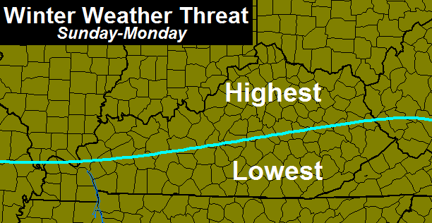
While accumulations of winter weather are a good bet, I’m not going to get too specific at the moment. Here is a general idea of the areas most at risk for winter weather…
That’s not set in stone as there is a ton of energy coming in from the southwest. The models will struggle on whether it comes out in pieces or all at once. They should settle down on a similar solution later tonight and early Saturday morning.
The prime time for winter weather around here will be from late Sunday afternoon through Monday morning.
It is possible for us to go into full blown threat mode later today. This storm has been on our radar for over a week now, so it should come as no surprise to those of you who are regular readers. You knew it was coming the moment I decided on trying to take a 4 day weekend. By the way… I have another 4 day weekend scheduled for the following week. I guess we know what that means. 😉
I will have the latest update on this potential on WKYT-TV starting at 4pm. Take care.

Sure is nice here on the farm today.
More of the same Saturday too ill take it.
The story of winter and now spring
Just when we hoped we had seen the last of the white stuff. And I just washed, waxed my Z71 & not to mention pressure washed the frame.
Please stop scheduling 4 day weekends!!!!
Thanks for all the posts and weather updates.
We appreciate your weather knowledge and accuracy.
That map looks familiar.
Looks like a summary of winter
Easy fix…stop taking 4 day weekends.
I’m starting to not like you, Chris! 🙂
Yea……..Hard to believe this is the anniversary of the 1993 superstorm. I was in western NC at the time……..Craziest snow storm I had ever seen at the time, then I moved here, and we had the feb 98 storm, and I was equally as impressed by that storm…..
Remember the 93 storm very well..unbelievable snowfall here in Leslie County..This storm, 20-30 inches, along with storm in April, 1987 24-32 inches, were the two largest snowfalls I have ever witnessed here in my home county of Leslie.
The biggest “snowstorm” I’ve ever been through was 5″, that was earlier this month. 🙁 I would love to see a snow like that one day…
As a kid in Western North Carolina we had many 2 foot snowstorms, but the best was the blizzard of 93. It dumped over three feet of snow with drifts covering most cars. It was fantastic. The world changed into an alien planet for a week or so. We can only dream of that sort of thing around here I’m afraid.
Yeah, remember that one very well.I’m gonna go out on a limb and say it will never be topped or equaled in my lifetime.
Chris, stop trying to take time off and the winter weather will stop!
Well he** I was hoping this low pressure was going to go way north way south or just fizzle out but nooo the low wants to actually take a track that gives alot of Ky wintery precip who would of thought!?! I guess the silver lining here is whatever wintry precip that possibly does fall won’t last long it is March after all. Last thing why isnt there a wind advisory out????? I think its needed winds are incredibly strong.
I don’t know. In Christian County, the wintry stuff last week hung around all week. It sleeted/Snowed on Sunday and as of last Friday morning, my street still has ice and snow.
Still a few days of winter left! I guess it wants to go out with a bang! I say bring it, but after next week the snow machine has to stop. I am out of salt?
Thanks for the update Chris! Does this mean your four day weekends during the summer will be cold or hot!
Oh brother. Here we go again
Please keep taking 4-day weekends, I not even close to tired of cold/snow. (That doesn’t mean I don’t want spring weather either) NAM has trended south in its most recent run, waiting to see what tonight’s models say, hoping southward trend continues.
Tonight’s 18z – 06z suites will be very interesting. We are right on the fence so it’s probably safe to say that each run will show a different solution for our area.
What are your early thoughts on this?
Chris, still rooting for you…guess that statement means you are nowe NOT taking a four day weekend? Boo on that! Anyway, thanks for the update. I know you will keep us informed. Wow! What wind we are having!
NWS Louisville Three items that may limit snow totals are a warmer layer aloft, perhaps a loss of deeper moisture aloft, and warm ground conditions. If the system is a bit stronger and more warm air aloft is pulled northward, we might be talking about more sleet and perhaps some freezing rain. Also, the ECMWF/NAM/GFS now indicate moisture begins to diminish above 600 or 700 hPa Sunday evening. This would greatly limit ice crystals, leaving a lot of supercooled droplets for possibly a mix of sleet and freezing rain. Additionally, the recent warm temperatures have really warmed the ground temps, which should reduce the snow/frozen precip totals a bit, at least at onset.
NWS Indianapolis NAM SEEMS OVER AGGRESSIVE ON ITS QPF AND HAS BEEN DISCARDED AS AN OUTLIER IN BEING TOO FAR NORTH WITH THE SURFACE LOW. WILL TREND CLOSER TO A EUROPEAN…GFS BLEND.
Summary, NWS Louisville says NAM is probably right but may bust. NWS Indianapolis says NAM too far north and strong and not buying any storm at all.
They rode the warm NAM with the ice storm earlier this winter. It didn’t work out well for that “rain” forecast.
Yeah it didn’t. I honestly will not say anything until tomorrow’s runs/trends. Thanks CB for keeping us updated and all your hard work!