Good Saturday, everyone. A developing winter storm is taking aim at the bluegrass state for Sunday into Sunday night. I almost pulled the trigger to a THREAT, but want to see how the computer model runs of today look. Either way, this looks to be another messy winter weather maker for much of the state.
I will be putting out that infamous first call map around noon today. But, I do want to touch on how the Friday night data was looking. Most of the models seem to be coming into agreement on a colder system with a greater chance for snow, sleet and some freezing rain.
The NAM is the most aggressive in showing significant amounts of frozen precipitation…
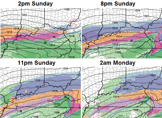
This particular run paints a broad brush of frozen precipitation accumulation across the state…
I still have to iron out the details, but the swath above isn’t too far from the map I put out on Friday.
The first call comes your way around noon today, so be looking for it. There is a better than even chance of upgrading to a THREAT during that time. Lucky us!
Enjoy your nice day and take care.

Wow, even a couple inches of snow would put frankfort around 30 inches for the winter, nothing we can do but just sit back and see what Mother Nature brings, Go Cats!
Lexington already has the 2nd snowiest winter since 1995-1996. We officially need 3.5 to make this the snowiest winter since 1995-1996. I’d say that possibility exists.
Louisville already has the snowiest winter since 1997-1998. They need 4.2 inches to make it the snowiest winter since 1995-1996
Thanks Chris
NAM throws totals way south. I have an animation of the sim radar from the NAM on my blog and you can see it trying to pop the cold air in a bit too soon. The GEM has trended a bit south as well. This will be a busy day for all the weather folks! I’m holding off on a forecast until I get off work around 4-5 this afternoon.
Give me a link to your blog please
Click on his name. That is the link.
My thinking is the NAM is going to far south GFS going to far north split the difference on this one. Either way there is a big bust potential which is just fine with me.
March storms are so fickle.
We could get a dusting on the big bust. We so could get an over achiever with 4-6″.
Obviously, with the month being March, the odds favor #1. Either way, still fun to see how mother nature plays this one out.
I don’t have to look at models to tell you what it will do in seky, same ol song and dance
So southeast ky gets hit hard again this winter…. Man I gotta get prepared for this cold rain storm….. Lol
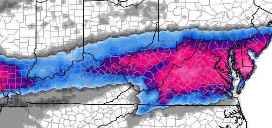
New WPC map for 4 inches or more of snow
http://www.hpc.ncep.noaa.gov/wwd/day2_psnow_gt_04.gif
And here is the one for ice
http://www.hpc.ncep.noaa.gov/wwd/day2_pice_gt_25.gif
And by new….12:54am to be precise. About an hour after CB posted his update.
WDRB is calling for 2-4 inches Louisville area and along Ohio River from Sunday into Monday. Here we go again ……
Shew even IF we get anything, it’s going to be gone quicker than it came down. I love how all the concentration is directed at winter and nobody mentions what a warm week we could be looking at. I’ll just enjoy my spring in the promise land of SE KY.
It is the middle of March. This storm could Buster Brown by the time Sunday gets here.
I would like to study the 12z run of the NAM a bit further. I could not understand the 06z run because there was too much disconnect of the data. 850mb temps between 0 and -4 does not support a complete changeover to snow yet snowfall maps suggest 1-3″ snow for areas along and just south of the Ohio River south into central KY about where the Parkways are located.
In my opinion, if the NAM is going to be the most accurate, it will be the 12z run. Then hopefully, there will be some consistency from run to run after that. But, I’m not counting on it.
NAM stays south at 12z.
Here in Leslie County we have done well with snowfall totals this year, at least 20+ inches for the entire winter..at least 2 storms with 4-7 inches county wide. Several factors enhance our snow totals, prime spot for upslope conditions that maximize snowfall rates, as well as elevation rises to 2,200 feet in the southern end of the county. I wish all of of the snow lovers in southern KY could have enjoyed this winter. 🙂 ….Winter, I believe, still may have some surprises. Here’s hoping that everyone can get a good system to enjoy!
You gotta love snowstorm possibilities with 60 degree weather before and after, March madness at its best! And GO CATS!