Good Saturday afternoon, gang. Our winter storm is on target to blast the bluegrass state Sunday into Sunday night. Rain, snow, sleet, freezing rain and a combination of the 4 will be likely during this time. With so many precipitation types, it’s going to be tough to pinpoint things.
I have put together a first call map, but I’ve kept this one pretty simple because of the complexity of the storm. Given the various precipitation types battling it out and a warm ground, I’m not getting carried away with totals. That could change with updates later today and tonight.
Here’s what I’m thinking…
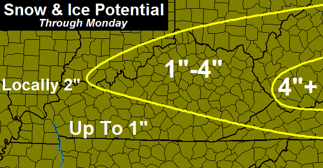
There’s some wiggle room with a storm like this. Totals can certainly go higher if the layer of cold air turns out to be deeper than I think. That would mean more in the way of snow as opposed to a mix. If that layer of cold is thinner… more rain and a mix will be noted.
The prime time for winter weather is from late Sunday afternoon through Monday morning.
If you’re wonder… I’m still on #teamrain. 🙂
I will update things again later this evening. Soak up today and take care.

It might as well snow. The white stuff will melt the next day.
I doubt it Is much of a Pavement sticker.
so I rather watch white falling from the sky. Than cold clear liquid
Temps looks warm for Monday….so is this just a fall and then melt situation?? any chance of a more southern track, like what happened with our last winter weather maker??
Certainly lots of wiggle room. These types of storms are incredibly hard to forecast.
Looks like Nashville’s all-time record single snow event will be safe once again 😉 .
March 14, 1892 – 17 inches
http://www.srh.noaa.gov/ohx/?n=historicalevents
Some more SkyWarn courses coming up, including in Georgetown, Campbellsville, Winchester, Danville as well as Jasper IN.
http://www.crh.noaa.gov/lmk/?n=spottertraining
Ditto for cities like Madisonville, Owensboro, Hopkinsville and Evansville IN.
http://www.crh.noaa.gov/pah/?n=spottertraining
Think Rain!!! #teamrain Go Cards! Be careful you tweaked up Cats!
Storm keeps trending south but weaker. Now NAM has a lousy inch or two “bullseye” around I-64 corridor, from Lexington and east. But dont blink, sometimes these March storms blow up in the matter of hours worth of model runs and all of a sudden we get pounded. (Which I do not think is likely, but you never know) I think this will be the last chance at getting over an inch snowfall for the rest of the season, I finally saw the first tree this spring that is starting to grow leaves, and its noticeable.
The way this winter has been, that is a pretty bold statement (last chance at over an inch), even given the transition to Spring.
Time will tell. 🙂
Short sleeves today coat tommorrow
Then back to the short sleeves. When will it end.
It’s basically been spring here in knott county since March started. Of 15 days we’ve had 10 with 50 degrees or higher. 2 days of what I call cold with highs in low 30s and 3 days in 40s.
The 12z run of the NAM does not offer much help in determining precipitation types except MIX. Perhaps that should be the new acronym for the NAM.
Higher elevations in Kentucky stand the best chance of accumulating snow.
It has not been an extreme month one way or the other. I think by the end of the month, Central Kentucky will average 1-2 degrees below normal with maybe one more shot at significant snow after this one.
One to two inches for Louisville all which will melt upon hitting the warmer ground. Will be nice to see one last snow. I Am ready to landscape and mow. Bring on spring and storms.
Winter weather advisory for far seky seems like a far stretch
Every day next week is in the 50s……..Except Monday.
So whether it’s a bust or over achiever ……it won’t matter, other than people needing to be careful and safe driving during the event itself.
Sweet 70 on the farm
The new 2:40pm WPC snowfall map.
http://www.hpc.ncep.noaa.gov/wwd/day1_psnow_gt_04.gif
http://www.hpc.ncep.noaa.gov/wwd/day2_psnow_gt_04.gif
This is a 64 corridor north storm looks like, still baffled over the winter weather advisory so early for seky
I’ve got a “first call” map up if anyone is interested in looking at that click my name. Still wanting to look over some new data before I commit to a final call.
All rain for Middlesboro is a sure bet and I’m not disappointed in the least. You guys in central KY are more than welcome to keep the snow and ice there. I’m in full blown Spring mode and care for that to be compromised. #teamrain rules!
nothing to see here, to warm for snow anywhere
Now there’s a rolocast that I can get behind.